Arnold's Cove

Last updated

Arnold's Cove
Town
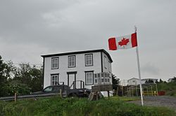
ArnoldsCoveNL DrakeHouse.JPG
Drake House
Arnoldscove.JPG
Canada Newfoundland location map.svg
Red pog.svg
Arnold's Cove
Location of Arnold's Cove in Newfoundland
Coordinates: 47°45′42″N53°58′57″W / 47.76167°N 53.98250°W / 47.76167; -53.98250
Country Flag of Canada (Pantone).svg  Canada
Province Flag of Newfoundland and Labrador.svg  Newfoundland and Labrador
Census division 1
Incorporated1967
Government
  MayorBasil Daley
Area
  Total4.79 km2 (1.85 sq mi)
Population
 (2021) [1]
  Total964
Time zone UTC-3:30 (Newfoundland Time)
  Summer (DST) UTC-2:30 (Newfoundland Daylight)
Area code 709
Highways NL TCH sign.svg Route 1 (TCH)

Arnold's Cove (2016 Population 949 [1] ) is a town on Newfoundland's Avalon Peninsula in the province of Newfoundland and Labrador, Canada. It is in Division 1 on Placentia Bay.

Contents

The name is found in population returns of 1836, and may have been given after the forename of a fisherman. [2] In 1864 there was one family, and by 1893 there was a post office. It was a fishing settlement located approximately two kilometers from the Newfoundland Railway, located 35 miles from Placentia Junction.

It was a Local Improvement District in 1967 and incorporated as a town the same year. It had a population of 100 in 1911 and 1,160 in 1976. It has been a center of economic growth recently, due to its proximity to projects involved with the Hibernia offshore oil platform.

Demographics

Historical populations
Division No. 2, NL
YearPop.±%
2001 1,024    
2006 1,003−2.1%
2011 990−1.3%
2016 949−4.1%
2021 964+1.6%
[3] [1]

In the 2021 Census of Population conducted by Statistics Canada, Arnold's Cove had a population of 964 living in 434 of its 547 total private dwellings, a change of

2016 census [1]
  Population change from 2011    -4.1%  
  Median age    51.3  
  Number of families    290  
  Number of married couples    230  
  Total number of dwellings    537  
  Land Area (km2.)    4.79  
North: Subdivision 1A
West: Come By Chance
Arnold's Cove
East: Subdivision 1A
South: Subdivision 1A

Attractions

Hiking trails

Arnold's Cove is home to three hiking trails [5] varying in length from a 12 km loop to a 2 km there-and-back. Bordeaux Trail is the longest, followed by the Old Cabot Highway to Arthur's Hill Trail with the Otter Rub/War Path Trail being the shortest of the three. All three trails are rated as Moderate or Easy/Moderate.

Lookout points

Two lookout points [5] exist within the town of Arnold's Cove. The Placentia Bay Lookout sits at the top of a hill, providing scenic views westward over Placentia Bay. Ivy's Lookout is small, mostly unmarked, and sits right on the water of Arnold's Cove itself, also looking west. Additionally, the Big Pond Bird Sanctuary, also known as the Arnold's Cove Bird Sanctuary, offers east-facing views of a tidal inlet that is home to local waterfowl.

Historic buildings

The Drake House is a home built in 1890 by George and John Drake in a standard Georgian style. It was awarded Heritage Designation by the Heritage Foundation of Newfoundland and Labrador in 2003. [6]

Religious buildings and cemeteries

Modern Arnold's Cove has four churches and no other listed religious buildings. It also has three cemeteries, two affiliated with the Anglican Church and one with the Salvation Army Church. [7]

See also

Related Research Articles

<span class="mw-page-title-main">Conception Harbour</span> Town in Newfoundland and Labrador, Canada

Conception Harbour is a town on the Avalon Peninsula in Newfoundland and Labrador, Canada. It is in Division 1 on Conception Bay and can be accessed via Newfoundland and Labrador Route 60.

Division No. 1, Subdivision A is an unorganized subdivision on the Avalon Peninsula in Newfoundland and Labrador, Canada. It is in Division No. 1, and lies between Trinity Bay and Placentia Bay.

<span class="mw-page-title-main">Come By Chance, Newfoundland and Labrador</span> Town in Newfoundland and Labrador, Canada

Come By Chance is a town on the isthmus of the Avalon Peninsula in Newfoundland and Labrador, Canada. It is in Division 1 on Placentia Bay.

Clarenville is a town on the east coast of Newfoundland in the province of Newfoundland and Labrador, Canada. Clarenville was incorporated in 1951. It is located in the Shoal Harbour valley, fronting an arm of the Atlantic Ocean called Random Sound.

<span class="mw-page-title-main">Division No. 1, Newfoundland and Labrador</span> Census division in Newfoundland and Labrador, Canada

Division 1, Newfoundland and Labrador is a census division covering the entire Avalon Peninsula including the Isthmus of Avalon of the Canadian province of Newfoundland and Labrador. Like all census divisions in Newfoundland and Labrador, but unlike the census divisions of some other provinces, the division exists only as a statistical division for census data, and is not a political entity.

Upper Island Cove, Newfoundland and Labrador is a town in Newfoundland and Labrador, Canada. It is located in Census Division No. 1 and was incorporated on October 19, 1965. It is located northeast of Bay Roberts. As of 2021, the population is 1,401.

Division No. 8 is a census division on the north coast of the island of Newfoundland in the province of Newfoundland and Labrador, Canada. It has a land area of 9,314.57 km² and had a population of 33,940 at the 2016 census. Its largest communities are the towns of Lewisporte, Springdale, and Twillingate.

<span class="mw-page-title-main">Grates Cove, Newfoundland and Labrador</span> Local service district / designated place in Newfoundland and Labrador, Canada

Grates Cove is a local service district and designated place in the Canadian province of Newfoundland and Labrador. It is the most northerly community on the Avalon Peninsula, located on the tip of the Bay de Verde Peninsula on the island of Newfoundland. Called "the Grates" by John Guy as early as 1612, the origin of the name is unknown.

New Chelsea-New Melbourne-Brownsdale-Sibley's Cove-Lead Cove is a local service district and designated place in the Canadian province of Newfoundland and Labrador.

<span class="mw-page-title-main">Woody Point, Newfoundland and Labrador</span> Town in Newfoundland and Labrador, Canada

Woody Point is a town located in the heart of Gros Morne National Park, on the western coast of Newfoundland. Situated on Bonne Bay, the Town of Woody Point encompasses three areas: Curzon Village, Woody Point and Winterhouse Brook. It has a total population of 244 residents. Woody Point is a Registered Heritage District and has a waterfront with many heritage buildings and four Registered Newfoundland and Labrador Heritage Structures. The community is served by Route 431.

Dover is a small incorporated fishing and lumbering village located in a small cove at the head of Freshwater Bay, Bonavista Bay, Newfoundland, Canada. Settled in the early 1890s it was originally known as Shoal Bay, presumably from its many shallow coves and inlets in the area. From the 1950s to the 1970 Shoal Bay was referred to as Wellington , whereas the local residents called it Dover.

Bay de Verde is an incorporated town in Conception Bay on the northern tip of the Bay de Verde Peninsula of Newfoundland and Labrador, Canada. The first recorded inhabitants at Bay de Verde arrived in 1662. Bay de Verde became an incorporated town in 1950.

<span class="mw-page-title-main">Frenchman's Cove, Newfoundland and Labrador</span> Town in Newfoundland and Labrador, Canada

Frenchman's Cove is a town on the west coast of Burin Peninsula, Newfoundland and Labrador, Canada. It had a population of 159 in the Canada 2021 Census, a drop from 172 in 2011. The town has been inhabited since before 1836, the earliest known documentation about it, when it appeared in the first Newfoundland Census. According to local folklore and tradition, the first settlers were named Cleuetts and were of French origin. The small-boat inshore fishery was the economic mainstay of the area until the late 1800s when did men went work on the schooners operating from Grand Bank. Residents also grew turnips, cabbages, and potatoes, as well as hay for their horses, cattle, sheep, and chickens.

Winterton is a town in the Canadian province of Newfoundland and Labrador. It was originally named Sille Cove or Scilly Cove. In 1912 the town was named Winterton for Sir James Spearman Winter, former Prime Minister of Newfoundland.

<span class="mw-page-title-main">St. Lunaire-Griquet</span> Town in Newfoundland and Labrador, Canada

St. Lunaire-Griquet is a town in the Canadian province of Newfoundland and Labrador. The town is located near the northern tip of the Great Northern Peninsula of Newfoundland. The town had a population of 603 in the Canada 2021 Census.

<span class="mw-page-title-main">Seal Cove, White Bay, Newfoundland and Labrador</span> Town in Newfoundland and Labrador, Canada

Seal Cove is a town in the Canadian province of Newfoundland and Labrador, located on White Bay. The town has had a stable population of just over 300 for more than a decade.

O'Donnells is a local service district and designated place in the Canadian province of Newfoundland and Labrador. It is southeast of Placentia. The first postmistress was Mrs. Theresa M. Hanlon on July 16, 1951. By 1956 there was a population of 244.

Harbour Round is a designated place in the Canadian province of Newfoundland and Labrador. It is east of Baie Verte.

Blaketown is a local service district and designated place in the Canadian province of Newfoundland and Labrador.

Patrick's Cove-Angels Cove is a local service district and designated place in the Canadian province of Newfoundland and Labrador. It is on the Cape Shore of the Avalon Peninsula. The area was first settled by James Coffey in the early 19th century. Coffey had moved to Newfoundland from County Waterford, Ireland to work at Placentia's Saunders and Sweetman firm. Sweetman's firm had sent some of their employees outward from Placentia to start farms in which to supply Sweetman's with produce. Coffey became the first resident of this community.

References

  1. 1 2 3 4 "Census Profile, 2016 Census: Arnold's Cove, Town [Census subdivision], Newfoundland and Labrador". Statistics Canada. 8 February 2017. Retrieved October 20, 2019.
  2. Place Names of Canada. Don Mills: Oxford University Press. 2010. p. 12.
  3. "2006 Community Profiles: Arnold's Cove, NL". Statistics Canada. 13 March 2007. Retrieved October 20, 2019.
  4. "Population and dwelling counts: Canada, provinces and territories, census divisions and census subdivisions (municipalities), Newfoundland and Labrador". Statistics Canada. February 9, 2022. Retrieved March 15, 2022.
  5. 1 2 "Attractions". Town of Arnold's Cove. Retrieved 2022-03-20.
  6. ACHeritage.ca. "Welcome to ACheritage.ca". ACHeritage.ca. Retrieved 2022-03-20.
  7. ACHeritage.ca. "Welcome to ACheritage.ca". ACHeritage.ca. Retrieved 2022-03-20.