
The Great Plains, sometimes simply "the Plains", is a broad expanse of flatland located west of the Mississippi River and east of the Rocky Mountains, much of it covered in prairie, steppe and grassland. It is the southern and main part of the Interior Plains of North America, which also include the tallgrass prairie between the Great Lakes and Appalachian Plateau, and the Taiga Plains and Boreal Plains ecozones in Northern Canada.

Prairies are ecosystems considered part of the temperate grasslands, savannas, and shrublands biome by ecologists, based on similar temperate climates, moderate rainfall, and a composition of grasses, herbs, and shrubs, rather than trees, as the dominant vegetation type. Temperate grassland regions include the Pampas of Argentina, Brazil and Uruguay, and the steppe of Ukraine, Russia and Kazakhstan. Lands typically referred to as "prairie" tend to be in North America. The term encompasses the area referred to as the Interior Lowlands of Canada, the United States, and Mexico, which includes all of the Great Plains as well as the wetter, hillier land to the east.

The Coteau des Prairies is a plateau approximately 200 miles in length and 100 miles in width, rising from the prairie flatlands in eastern South Dakota, southwestern Minnesota, and northwestern Iowa in the United States. The southeast portion of the Coteau comprises one of the distinct regions of Minnesota, known as Buffalo Ridge.

The Cypress Hills are a geographical region of hills in southwestern Saskatchewan and southeastern Alberta, Canada. The hills are part of the Missouri Coteau upland.

The Geography of North Dakota consists of three major geographic regions: in the east is the Red River Valley, west of this, the Missouri Plateau. The southwestern part of North Dakota is covered by the Great Plains, accentuated by the Badlands. There is also much in the way of geology and hydrology.
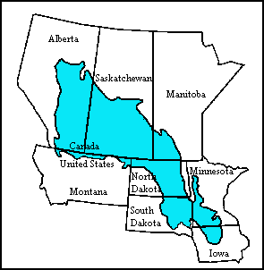
The Prairie Pothole Region is an expansive area of the northern Great Plains that contains thousands of shallow wetlands known as potholes. These potholes are the result of glacier activity in the Wisconsin glaciation, which ended about 10,000 years ago. The decaying ice sheet left behind depressions formed by the uneven deposition of till in ground moraines. These depressions are called potholes, glacial potholes, kettles, or kettle lakes. They fill with water in the spring, creating wetlands, which range in duration from temporary to semi-permanent. The region covers an area of about 800,000 sq. km and expands across three Canadian provinces and five U.S. states. The hydrology of the wetlands is variable, which results in long term productivity and biodiversity. The PPR is a prime spot during breeding and nesting season for millions of migrating waterfowl.
The Drift Prairie is a geographic region of North Dakota and South Dakota.

The geology of Minnesota comprises the rock, minerals, and soils of the U.S. state of Minnesota, including their formation, development, distribution, and condition.

Buffalo Ridge is a large expanse of rolling hills in the southeastern part of the larger Coteau des Prairies. It stands 1,995 feet (608 m) above sea level. The Buffalo Ridge is sixty miles (97 km) long and runs through Lincoln, Pipestone, Murray, Nobles, and Rock counties in the southwest corner of Minnesota.

South Dakota is a state located in the north-central United States. It is usually considered to be in the Midwestern region of the country. The state can generally be divided into three geographic regions: eastern South Dakota, western South Dakota, and the Black Hills. Eastern South Dakota is lower in elevation and higher in precipitation than the western part of the state, and the Black Hills are a low, isolated mountain group in the southwestern corner of the state. Smaller sub-regions in the state include the Coteau des Prairies, Coteau du Missouri, James River Valley, the Dissected Till Plains. Geologic formations in South Dakota range in age from two billion-year-old Precambrian granite in the Black Hills to glacial till deposited over the last few million years. South Dakota is the 17th-largest state in the country.
The geology of Saskatchewan can be divided into two main geological regions, the Precambrian Canadian Shield and the Phanerozoic Western Canadian Sedimentary Basin. Within the Precambrian shield exists the Athabasca sedimentary basin. Meteorite impacts have altered the natural geological formation processes. The prairies were most recently affected by glacial events in the Quaternary period.

Straddling the headwaters of the Minnesota River in west-central Minnesota, Big Stone National Wildlife Refuge is within the heart of the tallgrass prairie's historic range. Today, less than one-percent of tallgrass prairie remains.

Long Lake Wetland Management District encompasses three counties in south-central North Dakota, an area famed for its wealth of waterfowl-producing potholes and native prairie grasslands. Headquarters for the Wetland Management District is located in the Long Lake National Wildlife Refuge office near Moffit, North Dakota, which is about 35 miles southeast of Bismarck. Topographical landforms of the area include Missouri Coteau and Missouri River Slope. Precipitation averages just under 16 inches per year. Approximately 68 percent of the land in the three county area remains virgin sod - native mixed-grass prairie. The dominant land use is cattle grazing. The Coteau wetlands found in the northeastern portion of the Wetland Management District are classic prairie potholes of various sizes and types that are prime duck production habitat. These areas, when wet, are very productive. Soils in this area are generally deep and quite productive. Due to the rolling nature of the landscape on the Coteau, a lot of the land is also characterized as highly erodible. Conversely, many of the wetlands on Missouri River Slope portion of the Wetland Management District are large semi-permanent and permanent alkali wetlands. There are 21 wetland sites on the Missouri River Slope that have a history of periodic avian botulism outbreaks. These areas occasionally present localized problems for significant numbers of migratory birds. Soils on the Missouri River Slope are characteristically shallow with high proportions of sand and gravel. Much of the land is highly erodible. Since 1985, substantial land acreage in the three county area that was once farmed has been retired to Conservation Reserve Program grasslands. The program has assisted in restoring waterfowl populations for many species in the Wetland Management District which exceed the highest level ever recorded since surveys began.

Métis buffalo hunting began on the North American plains in the late 1700s and continued until 1878. The great buffalo hunts were subsistence, political, economic, and military operations for Métis families and communities living in the region. At the height of the buffalo hunt era, there were two major hunt seasons: summer and autumn. These hunts were highly organized, with an elected council to lead the expedition. This made sure the process was fair and all families were well-fed and provided for throughout the year.
The Battle of Grand Coteau or the Battle of Grand Coteau du Missouri was a battle fought between Métis buffalo hunters of Red River and the Sioux in North Dakota between July 13 and 14, 1851. The Métis were victorious. It was the last major battle between the two groups.

The Northern Mixed Grasslands is one of 867 terrestrial ecoregions defined by the World Wide Fund for Nature. This ecoregion includes parts of the Canadian provinces of Alberta, Saskatchewan, and Manitoba, north-central and eastern North Dakota, most of east South Dakota, and north-central Nebraska in the American Great Plains. The United States Environmental Protection Agency (EPA) defines this ecoregion as the Northern Glaciated Plains.

The basin that held Pleistocene Lake Musselshell is in the lower (north-flowing) reach of the river. It is underlain mostly by highly erodible Cretaceous Colorado shale, Montana group sandstone, siltstone and shale, and Hell Creek sandstone and shale. The bedrock is gently folded and affected by local faults and joints. There is a sequence of nine terraces and more than 100 glacial boulders. The terraces are older than the erratics as the erratics rest on the terraces.

Moose Mountain Upland, Moose Mountain Uplands, or commonly Moose Mountain, is a hilly plateau located in the south-east corner of Saskatchewan, Canada that covers an area of about 13,000 square kilometres. The upland rises about 200 metres above the broad, flat prairie which is about 600 metres above sea level. The highest peak is "Moose Mountain" at 830 metres above sea level. The area was named Moose Mountain because of the large number of moose that lived in the area. When it was originally used by fur traders, Métis, and the Indigenous peoples, the plateau was called Montagne a la Bosse, which is French for "The Mountain of The Bump or Knob."

Pipestone Creek is a river in the Souris River watershed. Its flow begins in south-eastern Saskatchewan, just south of the town of Grenfell and travels in a south-eastly direction into Manitoba in the Westman Region where it empties into Oak Lake through the Oak Lake Marsh.


