Antofalla and other Andean volcanoes form because the Nazca Plate is subducting beneath the South American Plate. Antofalla volcano is located in a region with a "basins and ranges" topography, where during the Miocene ranges were uplifted and basins formed through tectonic movement. It sits on a basement formed by Eocene-Miocene sedimentary units over a much older crystalline basement.
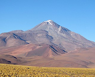
Antofalla is formed by a principal volcano, the 6,409-metre (21,027ft) high Antofalla volcano proper, and a surrounding complex of smaller volcanic systems that are formed by lava flows and pyroclastic material. The whole complex was active between 10.89 and 1.59 million years ago; whether activity occurred in historical time is unclear.
Name
The mountain is first attested in a map of 1900 as Antofaya, although an earlier map in 1632 uses the name Antiofac for the whole region.[2] The name may be derived from anta, anti, antu, which means "metal" (especially "copper") in the indigenous language Quechua.[3] Pedro Armengol Valenzuela hypothesized that the second part of the name is pallay, "collect"; thus the name Antofalla would mean "collection of copper".[4] Another theory is that Antofalla is derived from the Diaguita language.[5]
Antofalla is part of the Central Volcanic Zone of the Andes, which runs along the border between Argentina and Chile[1] and whose main expression occurs in the Western Cordillera.[14] The volcanoes of the Central Volcanic Zone lie at high altitudes, and the volcanic zone spans the countries of Argentina, Bolivia, Chile and Peru.[15] Present-day activity in the Central Volcanic Zone occurs at Lascar and Lastarria,[16] and about 44 centres have been active in the Holocene.[17] Aside from stratovolcanoes, calderas with large ignimbrites are also part of the Central Volcanic Zone; the Altiplano–Puna volcanic complex is a complex of such large calderas.[18]
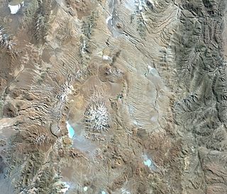
Antofalla is a cluster of stratovolcanoes,[19] with the 6,409-metre (21,027ft) high Antofalla volcano at its centre.[20][1] An altar with a stone pyramid lies on its summit,[21] and the mountains Llullaillaco, Pajonales and Pular can be seen from the top of the mountain.[22]
A number of other centres developed around the main Antofalla volcano, forming a 50-kilometre (31mi) wide volcanic area;[20][1] counterclockwise from the north these are:[10][23]
5,765-metre (18,914ft) high[24] Cerro Patos (with the neighbouring 5,761-metre (18,901ft) high Cerro Ojo de Antofalla[12])
5,704-metre (18,714ft)[25] or 5,783-metre (18,973ft)[26] high Cerro Lila
5,700-metre (18,700ft)[27] or 5,787-metre (18,986ft)[26] high Cerro Cajeros
5,750-metre (18,860ft)[27] or 5,785-metre (18,980ft)[26] high Cerro de la Aguada, also known as Cerro Botijuelas[28]
Cerro Bajo-Cerro Onas
5,656-metre (18,556ft) high[26] Conito de Antofalla.
These volcanic centres overlap with each other,[29] are all much smaller than the main Antofalla volcano and have experienced little erosion. All these volcanoes are formed by lava domes, lava flows and pyroclastic units.[30] Ignimbrites are also found and one of these forms Cerro Onas,[31] while a more recent one occurs in the Quebrada de las Cuevas area.[32] Between Cerro de la Aguada and Cerro Cajeros lies the Cerro la Botijuela obsidian dome.[31] On the western and southwestern side of the complex, some cinder cones can be found,[30] and fissure vents linked to faults cut through the volcanic complex.[33] Finally, a sector collapse deposit and collapse amphitheatre can be observed at Quebrada de las Minas and Quebrada el Volcán.[32] A large scale topographic anomaly surrounds the entire volcanic complex,[34] and seismic tomography has shown the presence of low-velocity anomalies linked to the volcanic group.[35]
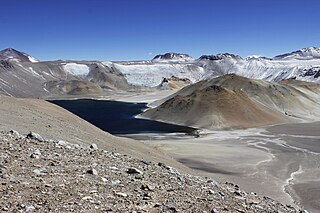
The Salar de Antofalla, one of the largest salt pans in the world,[21] lies southeast of the Antofalla complex.[30] It is one of many salt pans that developed within closed basins of the region and its surface lies at an elevation of 3,340 metres (10,960ft);[36] other such salt pans include Salar Archibarca north-northwest of Antofalla,[37]Salina del Fraile south-southwest and Salar del Rio Grande northwest.[38] There also are several lakes such as Laguna Las Lagunitas on the northeastern foot of Antofalla, Laguna Patos west of Cerro Lila – Cerro Ojo de Antofalla and Laguna Cajeros southwest of Cerro Lila – Cerro Cajeros. Most of the northwestern flank of the main Antofalla volcano drains into the Salar de Archibarca, while the southeastern flank has drainages connecting it to the Salar de Antofalla through the (from northeast to southwest) Quebrada de las Cuevas, Quebrada del Volcan and Quebrada de las Minas; the latter two join before entering the salt pan[12] in a large fan, the Campo del Volcán.[10] Northeast of the Conito de Antofalla, the Rio Antofalla originates and flows southeastward into the Salar de Antofalla[12] in a large alluvial fan, similar to other drainages that enter the Salar de Antofalla.[39] South of Antofalla lies Vega Botijuela,[10] where there are two hot springs.[40] One of them discharges 32°C (90°F) warm water at a rate of 2–4 cubic metres per minute (33–67L/s)[41] from the Botijuela normal fault,[40] has emplaced a 550 metres (1,800ft) wide travertine.[42] There is an artificial man-made pool.[43] Apart from the active springs, at Botijuela there are deposits from inactive springs[44] including a conspicuous travertine cone,[45][46] an extinct geyser. Other warm springs in the area are Vega Antofalla, El Hervidero and Te bén Grande; they may be nourished by thermal waters that ascent on faults.[47]
Geology
Off the western coast of South America, the Nazca Platesubducts beneath the South American Plate[48] at a rate of about 10 centimetres per year (3.9in/year);[49] this subduction is responsible for volcanic activity in the Central Volcanic Zone[18] and elsewhere in the Andes.[48] Volcanism does not occur along the entire length of the subduction zone; north of 15° and south of 28° the subducting plate moves downward at a shallower angle and this is associated with the absence of volcanic activity.[14] Other volcanic zones exist in the Andes, including the Northern Volcanic Zone in Colombia and Ecuador[48] and the Southern Volcanic Zone also in Chile.[50] A furtherourth volcanic zone, the Austral Volcanic Zone, is caused by the subduction of the Antarctic Plate beneath the South American Plate and lies south of the Southern Volcanic Zone.[15]
A fault runs in north–south direction in the western part of the Antofalla complex.[51] Many geologic lineaments control tectonics across the whole region, they direct the ascent of magma and the location of basins; some of these lineaments exist since the Precambrian. One of these lineaments in the region trends north-northeast and separates the Arequipa-Antofallaterrane from the Pampia terrane.[23]
Geologic record
The regional geography developed during the Middle and Late Miocene, when basins and ranges were formed by thrusting and subsidence; the basins were filled with evaporites above older molasse-like material, while the ranges are mainly formed by Paleozoic rocks. Precambrian and Late Cretaceous rocks crop out in the Eastern Cordillera on the eastern margin of the Puna.[52] The tectonic activity decreased about 9 million years ago, with the exception of a brief reactivation less than 4 million years ago. The present-day southern Puna is tectonically quiescent,[53] although fault scarps indicate recent ground movements.[54]
The oldest volcanic activity occurred during the Permian and early Jurassic, and the present-day manifestations consist mainly of lava and pyroclastic material. During the Cenozoic, a number of now inactive volcanoes and ignimbrites, the latter of which typically have volumes of less than 10 cubic kilometres (2.4cumi), erupted in the region.[55] Only less than 15-centimetre (5.9in) thick ignimbrites were deposited during the Eocene-early Miocene, probably from vents in the Coastal Cordillera.[19] During the Eocene, the subduction became shallower, moving volcanism eastward into the main Andes.[1] Volcanic activity dramatically increased during the Miocene, during which large stratovolcanoes and ignimbrites were emplaced; it is often not clear from which centre a given ignimbrite is sourced from.[19] Later volcanic activity was characterized by the emplacement of ignimbrites and of monogenetic volcanoes, which consist of cinder cones and lava flows with small volumes. Some of these cones are partially eroded,[56] other ones have a fresh appearance and these are as little as 200,000 ± 90,000 years old,[57] with even more recent (Holocene) activity possible.[58] While the Miocene phase of high activity was linked to a fast subduction regime, the monogenetic activity may be linked to delamination of the crust beneath the Puna instead[16] as well as with a change in tectonic regime that favoured crustal extension.[59] The transition between the two volcanic phases was characterized by a decrease in volcanic activity.[36]
The Juan Fernández Ridge was subducted in the region between 11–8 million years ago according to Kraemer et al. 1999. This may have generated a flat subduction profile and thus allowed volcanic arc-like volcanism to occur in the region behind the actual volcanic arc.[60]
Local
Antofalla lies in the Salar de Antofalla area[11] of the Argentine Puna, a high plateau located over a thick crust of the Andes. It is a basin and range-like region with volcanoes.[14] Before the Neogene the region was not part of the Andes proper, being located behind the mountain chain, and was integrated into the mountain chain by tectonic movements.[61]
Antofalla together with neighbouring Cerro Archibarca, Cerro Beltrán and Tebenquicho is part of a group of long lived volcanic complexes that developed in the Argentine Puna;[29][19] the first and the last of these lie due north and northeast of Antofalla, respectively.[23] All of them appear to be associated with a lineament known as the Archibarca lineament, which crosses the Andes in northwest–southeast direction,[56] and which additionally includes the Escondidaore occurrence[23] and the volcanoes Llullaillaco, Corrida de Cori and Galán.[1] This lineament may be an area where the crust is unusually weak.[56] Other such lineaments in the Andes are the Calama-Olacapato-El Toro lineament and the Culampajá one.[1]Seismic tomography has found a low-velocity zone under Antofalla, which may be an active magma body.[62]
The terrain beneath the volcano is formed in part by the crystalline basement of Precambrian-Paleozoic ("Antofalla Metamorphites"[63]) age mainly north of the volcano and often interpreted as ophiolite, and by sedimentary units of Eocene-Miocene age that crop out on its southern side and by a conglomerate unit known as the Potrero Grande Formation.[64] Parts of the basement crop out where it have been exposed by erosion, such as in the Rio Antofalla and the Quebrada de las Minas,[64] and more generally in two sectors north and south of the volcano.[38]
Magma genesis appears to involve extensive interactions with the lower crust, a process which at first gave rise to rhyolitic material; later the now heavily altered crust interacted less with newer magmas and thus a more basaltic andesite-andesite-dacite unit developed.[68]
Hydrothermal alteration has occurred on the southeastern flanks of the complex at Quebrada de las Minas and on Antofalla's western flank.[30] Volcanic systems like Antofalla and volcano-plutonic complexes often develop mineral deposits through hydrothermal and epithermal processes; such has also happened at Antofalla, yielding occurrences of gold, lead, silver and zinc. These became targets of mining operations:
The latter three extracted on the eastern side of Antofalla in the old Los Jesuitas mine.[1]
There are ruins of a gold mining settlement close to the town of Antofalla.[21]
A map of 1900 mentions the existence of an Antofaya silver mine on the southeastern side of the complex.[2]
A more recent map showing the existence of a mining site on Quebrada de las Minas.[12]
Mining at Antofalla goes back to 1700 at least,[69] and infrastructure includes mills.[70] Significant ore deposits may exist at the volcano,[64] but their deep burial in the poorly eroded volcanic complex hampers their exploitation.[71]
Climate, vegetation and fauna
Antofalla lies in a region of arid climate, with about 150 millimetres per year (5.9in/year) precipitation, much of it in the form of snow at high elevations. Temperatures change drastically from day to night and vice versa,[72] ranging from −20–40°C (−4–104°F) in the wider region; the climate has been characterized as continental.[8] The region lies between two major climatic regimes, a northerly regime dominated by easterly moisture flows which occur during summer, and a southerly regime where westerlies transport moisture from the west mainly in winter.[73]
Animals in the region include llamas, various rodents and vicuñas, as well as carnivores such as Darwin's rhea, pumas and South American foxes. Human hunters were also active in the region and have left a number of archeological traces, including projectiles[74] and trenches where hunters hid from prey.[75] The extreme climate and scarcity of water restrict human habitation to small areas, however.[8]
Climatological implications
During winter snow covers the peaks; meltwater formed during spring has cut gullies into the mountains.[30] There are not many creeks on Antofalla that carry water year round, although deep ravines with evidence of flash flood activity can be discerned.[32]
The main Antofalla volcano may have been glaciated during the Pleistocene,[30] but this is disputed especially for the lower mountains of the complex.[25] It is likely that in the past, more water was available and led to the deposition of alluvial fans at the margins of basins[32] although there is no evidence that a lake ever formed in the Salar de Antofalla, unlike in other salars farther north.[46] Indeed, the early Holocene was colder and wetter than present-day, and precipitation may have reached 0.5 metres per year (20in/year).[72]
Eruptive history
The Antofalla complex has been active from the Miocene 11 million years ago into the Quaternary and has generated a large variety of volcanic rocks;[1] it is thus considered to be a very long-lived volcano.[76] The subsidiary peaks around Antofalla were all considered to be extinct by Ferdinand von Wolff.[28]
The first phase of volcanic activity occurred between 10.89 and 10.1 million years ago. At that time, eruptions covered the terrain beneath the volcano with ignimbrites of rhyolitic composition.[77] Subsequently, lava flows of mafic[a] to trachydacitic composition were emplaced, in part on top of the earlier ignimbrites.[79] Between 9.09 and 1.59 million years ago activity was continuous and dominated by lava flows of andesitic to dacitic composition, which constructed the main Antofalla volcano and the surrounding vents. Small felsic[b] eruptions generating lava domes and ignimbrites concluded this activity, with the ignimbrite in Quebrada de las Cuevas dated to 1.59 ± 0.08 million years ago.[80] Other volcanic units attributed to this volcanic complex are the Aguas Calientes basalt,[81] the Los Patos ignimbrite[82] of lower Pliocene age[83] and the Tambería Ignimbrite.[84]
Even later, several mafic centres grew southwest and west of the Antofalla complex.[80]Fumarolic activity continues to this day,[85] the existence of geysers was reported in 1962[86] and traces of an extinct geyser such as sinter structures have been found at Botijuelas.[28] There are reports that the main volcano "smoked" occasionally[28] such as in 1901 and 1911[20] and Antofalla is sometimes incorrectly considered the highest active volcano in the world,[87] but the Global Volcanism Program considers the complex as Pleistocene in age,[20] and no clear evidence of Holocene activity is found.[58]
Climbing
Antofalla is a technically simple climb and there are guides in the region. The main Antofalla volcano can be ascended in three days, although the paths are not always easy to reach by vehicle. Low temperatures and high wind are common issues.[21]
Cerro Escorial is a stratovolcano at the border of Argentina and Chile. It is part of the Corrida de Cori volcanic group and its youngest member. A well-preserved 1-kilometre-wide (0.6 mi) crater forms its summit area. Lava flows are found on the Chilean and smaller ones on the Argentinian side, the former reaching as far as 3–4 kilometres (1.9–2.5 mi) from the volcano. One of these is dated 342,000 years ago by argon-argon dating.
Peinado is a stratovolcano in Catamarca Province, Argentina. It consists of a volcanic cone with a summit crater, surrounded at its foot by lava flows erupted from flank vents. It began erupting about 100,000 years ago, with the last eruption about 36,800 years ago. Future eruptions are possible.
Cerro Galán is a caldera in the Catamarca Province of Argentina. It is one of the largest exposed calderas in the world and forms part of the Central Volcanic Zone of the Andes, one of the three volcanic belts found in South America. One of several major caldera systems in the Central Volcanic Zone, the mountain is grouped into the Altiplano–Puna volcanic complex.
La Pacana is a Miocene age caldera in northern Chile's Antofagasta Region. Part of the Central Volcanic Zone of the Andes, it is part of the Altiplano-Puna volcanic complex, a major caldera and silicic ignimbrite volcanic field. This volcanic field is located in remote regions at the Zapaleri tripoint between Chile, Bolivia and Argentina.
Cerro Beltrán is an andesitic-dacitic volcano in the Andes. It erupted andesitic-dacitic lava flows between 14.1 and 7.7 mya. Based on geochemical considerations, the volcano formed from granite and plagioclase bearing, 33–40 kilometres (21–25 mi) thick crust. Part of the volcano was later covered by ignimbrites coming from the Galán caldera eruption.
Cerro Archibarca is a volcano in the Andes, in Salta Province, Argentina. It covers a surface area of 20 square kilometres (7.7 sq mi). Lava flows descend from a conical edifice. It was active 11 million years ago. The youngest deposits are eroded andesites on the northern side.
Corrida de Cori is a mountain range in Argentina and Chile. It consists of several aligned volcanoes, including Cerro Escorial, which exceed 5 kilometres (3.1 mi) in elevation. The range, together with several local volcanoes, forms an alignment that may be controlled by a fault system. The volcanoes erupted mainly andesite and basaltic andesite, they were active in the Plio-Pleistocene with the most recent activity occurring at Cerro Escorial and at a cinder cone east of the range. There are two mines in the area, with a weather station nearby.
Nevados de Pastos Grandes is a Miocene volcanic centre in the Puna, Salta province, Argentina. It is a volcanic complex with several centres named El Queva, Gordo and Azufre. Some minor Pleistocene glaciation has affected the volcanic complex.
Incapillo is a Pleistocene-age caldera in the La Rioja Province of Argentina. It is the southernmost volcanic centre in the Andean Central Volcanic Zone (CVZ) that erupted during the Pleistocene. Incapillo is one of several ignimbrite or caldera systems that, along with 44 active stratovolcanoes, comprise the CVZ.
Laguna Amarga is a caldera and associated ignimbrite in the Andes of northwestern Argentina.
Llullaillaco is a dormant stratovolcano on the border between Argentina and Chile. It lies in the Puna de Atacama, a region of tall volcanic peaks on a high plateau close to the Atacama Desert, one of the driest places in the world. Its maximum elevation is most commonly given as 6723 m, making it the second- or third-highest volcano in the world. Despite its height, it is not clear whether the volcano has any glaciers or merely patches of perennial snow and ice. Between 3700 m and 5000 m elevation there is a sparse plant cover, while at lower altitudes the climate is too dry for plants to grow. A species of mouse on Llullaillaco is the highest-living known vertebrate species.
Luingo is a caldera in the Andes of Argentina. It is located southeast of the Galan caldera. The caldera is not recognizable from satellite images and is associated with the Pucarilla-Cerro Tipillas volcanic complex.
Cerros Bravos-Barros Negros is a volcanic complex in the Maricunga Belt in Chile. This 200-kilometre-long (120 mi) volcanic belt formed during the Oligocene-Miocene west of the Puna; the present-day Central Volcanic Zone lies northeast of the Maricunga Belt.
Negro de Chorrillos is a volcano in the Andes.
Tebenquicho is a volcano in Argentina.
Vicuña Pampa is a volcano in Argentina. It is part of the Central Volcanic Zone of the Andes and is located on the southeastern margin of the Puna plateau. It consists out of a 30 kilometres (19 mi) wide volcanic complex that is constructed by outwards-propagating lava flows. The centre of the complex is carved out by a 18 kilometres (11 mi) wide depression, which was originally interpreted as a caldera but appears to be erosional in origin. It is drained southward by the Rio Vicuña Pampa.
Vilama is a Miocene caldera in Bolivia and Argentina. Straddling the border between the two countries, it is part of the Central Volcanic Zone, one of the four volcanic belts in the Andes. Vilama is remote and forms part of the Altiplano-Puna volcanic complex, a province of large calderas and associated ignimbrites that were active since about 8 million years ago, sometimes in the form of supervolcanoes.
Cerro Tuzgle is a dormant stratovolcano in the Susques Department of Jujuy Province in northwestern Argentina. Tuzgle is a prominent volcano of the back arc of the Andes and lies about 280 kilometres (170 mi) east of the main volcanic arc. Part of the Central Volcanic Zone of the Andes, its summit is 5,486 metres (17,999 ft) above sea level and it grew during different stages over a caldera and lava domes. Some major lava flows emanate from the summit crater, and one confirmed and one possible flank collapse unit as well as an ignimbrite sheet are associated with Tuzgle.
Coranzulí is a Miocene caldera in northern Argentina's Jujuy Province. Part of the Argentine Andes' volcanic segment, it is considered a member of the Central Volcanic Zone (CVZ). At the heart of the CVZ lies the Altiplano-Puna volcanic complex, a group of volcanoes of which Coranzulí is a part: the complex has produced large ignimbrite sheets with a combined volume approaching 15,000 cubic kilometres (3,600 cu mi).
Cerro Panizos is a late Miocene-age shield-shaped volcano spanning the Potosi Department of Bolivia and the Jujuy Province of Argentina. It features two calderas and a group of lava domes. It is part of the Altiplano-Puna volcanic complex (APVC), a group of calderas and associated ignimbrites that erupted during the past ten million years. Cerro Panizos is part of the Central Volcanic Zone (CVZ), a volcanic arc that extends from Peru to Chile which was formed mostly by subduction of the Nazca Plate beneath South America.
↑ Holmer, Nils M. (19 July 2013). "Indian Place Names in South America and the Antilles. II". Names. 8 (4): 207–208. doi:10.1179/nam.1960.8.4.197.
↑ Valenzuela, P. A. (1918). Glosario etimológico de nombres de hombres, animales, plantas, ríos y lugares, y de vocablos incorporados en el lenguaje vulgar: aborígenes de Chile, y de algún otro país americano. (in Spanish). Vol.1. Imprenta universitaria. p.38 – via Google Books.
1 2 3 4 Kay, Suzanne Mahlburg; Coira, Beatriz; Mpodozis, Constantino (2008). "Field trip guide: Neogene evolution of the central Andean Puna plateau and southern Central Volcanic Zone". In Kay; Ramos, Víctor A. (eds.). GSA Field Guide 13: Field Trip Guides to the Backbone of the Americas in the Southern and Central Andes: Ridge Collision, Shallow Subduction, and Plateau Uplift. Vol.13. p.147. doi:10.1130/2008.0013(05). ISBN978-0-8137-0013-7.
1 2 Siebel, Wolfgang; Schnurr, Wolfgang B.W.; Hahne, Knut; Kraemer, Bernhard; Trumbull, Robert B.; van den Bogaard, Paul; Emmermann, Rolf (January 2001). "Geochemistry and isotope systematics of small- to medium-volume Neogene–Quaternary ignimbrites in the southern central Andes: evidence for derivation from andesitic magma sources". Chemical Geology. 171 (3–4): 214. Bibcode:2001ChGeo.171..213S. doi:10.1016/S0009-2541(00)00249-7. ISSN0009-2541.
1 2 3 4 Von Wolff, F (1929). Der Volcanismus II Band: Spezieller Teil 1 Teil Die Neue Welt (Pazifische Erdhalfte) der Pazifische Ozean und Seine Randgebiete (in German). Stuttgart: Ferdinand Enke. p.350.
1 2 Perucca, Laura P.; Moreiras, Stella M. (2009). "Seismic and Volcanic Hazards in Argentina". In Latrubesse, Edgardo (ed.). Natural Hazards and Human-Exacerbated Disasters in Latin America. Developments in Earth Surface Processes. Vol.13. p.291. doi:10.1016/S0928-2025(08)10014-1. ISBN9780444531179.
↑ Lavandaio, Eddy Omar Luis; Catalano, Edmundo (2004). Historia de la Minería Argentina (Report). Argentina Servicio Geológico Minero Argentino Instituto de Geología y Recursos Minerales. p.1. ISSN0328-2325.
↑ Cienfuegos, Francisco Solano Asta-Buruaga y (1899). Diccionario geográfico de la República de Chile (in Spanish). Imp. de F. A. Brockhaus. p.43.
↑ Colqui, Benito S. (1962). "Argentine Glaciology". Antarctic Research: The Matthew Fontaine Maury Memorial Symposium. Geophysical Monograph Series. Vol.7. American Geophysical Union. p.223. doi:10.1029/GM007p0217. ISBN9781118668788.
↑ Molina, Eduardo Gomez; Little, Adrienne V. (1981). "Geoecology of the Andes: The Natural Science Basis for Research Planning". Mountain Research and Development. 1 (2): 115–144. doi:10.2307/3673119. JSTOR3673119.
Sources
de Silva, Shanaka L.; Davidson, Jon P.; Croudace, Ian W.; Escobar, Angel (March 1993). "Volcanological and petrological evolution of Volcan Tata Sabaya, SW Bolivia". Journal of Volcanology and Geothermal Research. 55 (3–4): 305–335. Bibcode:1993JVGR...55..305D. doi:10.1016/0377-0273(93)90043-Q. ISSN0377-0273.
Giovanini Varejão, Filipe; Alonso, Guido E.; Athayde, Gustavo B.; Bahniuk Rumbelsperger, Anelize M.; Cury, Leonardo F. (11 October 2024). "Facies stacking and lateral variability of travertines from the Quaternary Vega Botijuela, Salar de Antofalla Basin, Argentina". Sedimentology. doi:10.1111/sed.13240.
Kraemer, B.; Adelmann, D.; Alten, M.; Schnurr, W.; Erpenstein, K.; Kiefer, E.; van den Bogaard, P.; Görler, K. (March 1999). "Incorporation of the Paleogene foreland into the Neogene Puna plateau: The Salar de Antofalla area, NW Argentina". Journal of South American Earth Sciences. 12 (2): 157–182. Bibcode:1999JSAES..12..157K. doi:10.1016/S0895-9811(99)00012-7. ISSN0895-9811.
Moreno, Enrique (March 2012). "The construction of hunting sceneries: Interactions between humans, animals and landscape in the Antofalla valley, Catamarca, Argentina". Journal of Anthropological Archaeology. 31 (1): 104–117. doi:10.1016/j.jaa.2011.10.006. ISSN0278-4165.
Richards, Jeremy P.; Ullrich, Thomas; Kerrich, Robert (April 2006). "The Late Miocene–Quaternary Antofalla volcanic complex, southern Puna, NW Argentina: Protracted history, diverse petrology, and economic potential". Journal of Volcanology and Geothermal Research. 152 (3–4): 197–239. Bibcode:2006JVGR..152..197R. doi:10.1016/j.jvolgeores.2005.10.006. ISSN0377-0273.
Seggiaro, Raúl E.; Becchio, Raúl; Pereyra, Fernando X.; Martínez, Liliana (2007). "Hoja Geológica 2569-IV Antofalla"(PDF). REPOSITORIO INSTITUCIONAL SEGEMAR (in Spanish). Servicio Geológico Minero Argentino. Retrieved 15 June 2018.
Varejão, Filipe G.; Warren, Lucas V.; Alessandretti, Luciano; Rodrigues, Mariza G.; Ricomini, Claudio; Assine, Mario; Cury, Leonardo F.; Faleiros, Frederico M.; Simões, Marcello G. (October 2022). "Late Permian siliceous hot springs developed on the margin of a restricted epeiric sea: Insights into strata-confined silicification in mixed siliciclastic‑carbonate successions". Palaeogeography, Palaeoclimatology, Palaeoecology. 604: 111213. doi:10.1016/j.palaeo.2022.111213. S2CID251917064.
External links
Biggar, John (2020). The Andes: A Guide for Climbers for Climbers and Skiers. Andes. p.218. ISBN978-0-9536087-6-8.
This page is based on this Wikipedia article Text is available under the CC BY-SA 4.0 license; additional terms may apply. Images, videos and audio are available under their respective licenses.