Borobudur, also transcribed Barabudur, is a 9th-century Mahayana Buddhist temple in Magelang Regency, near the city of Magelang and the town of Muntilan, in Central Java, Indonesia.

Central Java is a province of Indonesia, located in the middle of the island of Java. Its administrative capital is Semarang. It is bordered by West Java in the west, the Indian Ocean and the Special Region of Yogyakarta in the south, East Java in the east, and the Java Sea in the north. It has a total area of 33,750.37 km2, with a population of 36,516,035 at the 2020 Census making it the third-most populous province in both Java and Indonesia after West Java and East Java. The official population estimate in mid-2023 was 37,608,336 The province also includes a number of offshore islands, including the island of Nusakambangan in the south, and the Karimun Jawa Islands in the Java Sea.

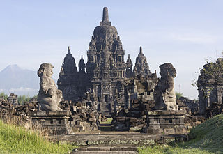
Prambanan is a 9th-century Hindu temple compound in the Special Region of Yogyakarta, in southern Java, Indonesia, dedicated to the Trimūrti, the expression of God as the Creator (Brahma), the Preserver (Vishnu) and the Destroyer (Shiva). The temple compound is located approximately 17 kilometres (11 mi) northeast of the city of Yogyakarta on the boundary between Central Java and Yogyakarta provinces.

Magelang is one of six cities in the Central Java Province of Indonesia that are administratively independent of the regencies in which they lie geographically. Each of these cities is governed by a mayor rather than a bupati. Magelang City covers an area of 18.56 km2 and had a population of 118,227 at the 2010 census and 121,526 at the 2020 census; the official estimate as at mid-2023 was 122,150. It is geographically located in the middle of the Magelang Regency, between Mount Merbabu and Mount Sumbing in the south of the province, and lies 43 km north of Yogyakarta, 15 km north of Mungkid and 75 km south of Semarang, the capital of Central Java.

The Mataram Kingdom ; also known as Medang Kingdom was a Javanese Hindu-Buddhist kingdom that flourished between the 8th and 11th centuries. It was based in Central Java, and later in East Java. Established by King Sanjaya, the kingdom was ruled by the Shailendra dynasty and Ishana dynasty.

The Sanjaya dynasty was a Javanese dynasty which ruled the Mataram Kingdom in Java during the first millennium CE. The dynasty promoted Hinduism on the island.

Yogyakarta is the capital city of the Special Region of Yogyakarta in Indonesia, in the south-central part of the island of Java. As the only Indonesian royal city still ruled by a monarchy, Yogyakarta is regarded as an important centre for classical Javanese fine arts and culture such as ballet, batik textiles, drama, literature, music, poetry, silversmithing, visual arts, and wayang puppetry. Renowned as a centre of Indonesian education, Yogyakarta is home to a large student population and dozens of schools and universities, including Gadjah Mada University, the country's largest institute of higher education and one of its most prestigious.

Sleman Regency is an Indonesian regency on the island of Java. It is located in the north of the Yogyakarta Special Administrative Region, Indonesia, and has an area of 574.82 square kilometres (221.94 sq mi), with a population of 1,093,110 at the 2010 Census and 1,125,804 at the 2020 Census; the official estimate as at mid 2023 was 1,157,292 - comprising 573,760 males and 583,540 females. Its capital is the town of Sleman. The current regent is Kustini Sri Purnomo.

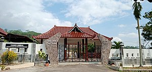
A candi is a Hindu or Buddhist temple in Indonesia, mostly built during the Zaman Hindu-Buddha or "Hindu-Buddhist period" between circa the 4th and 15th centuries.

Kedu Plain, also known as Progo River Valley, is the fertile volcanic plain that lies between the volcanoes Mount Sumbing and Mount Sundoro to the west, and Mount Merbabu and Mount Merapi to the east. It roughly corresponds to the present-day Magelang and Temanggung Regency of Central Java, Indonesia.

Trowulan is an archaeological site in Trowulan Subdistrict, Mojokerto Regency, in the Indonesian province of East Java. It includes approximately 100 square kilometres and has been theorized to be the site of the eponymous capital city of the Majapahit Empire, which is described by Mpu Prapanca in the 14th-century poem Nagarakretagama and in a 15th-century Chinese source. When it was the capital of the Majapahit Empire, the city was known as Wilwatikta, which is a name also synonymous with the empire's name. It was razed during the invasion of Girindrawardhana to defeat Kertabhumi in 1478. After this event Majapahit's capital was moved to Daha (Kediri). The Trowulan Museum includes a collection of artifacts.
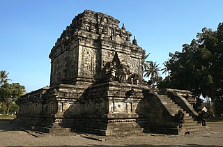
Mendut is a ninth-century Buddhist temple, located in Mendut village, Mungkid sub-district, Magelang Regency, Central Java, Indonesia. The temple is located about three kilometres east of Borobudur. Mendut, Borobudur, and Pawon, all of which are Buddhist temples, are located in one straight line. There is a mutual religious relationship between the three temples, although the exact ritual process is unknown.

Gedong Songo is a group of Hindu temples located near Bandungan, Semarang Regency, in north Central Java, Indonesia. It is variously dated between the 8th and 9th-century. Built around a 1,270 metres (4,170 ft) hill near Mount Ungaran, it consist of five Gedong – two on the east side of the hill, two towards the north and one to the west. These total nine temples, all dedicated to Shiva and Parvati. The Gedong Songo complex is one of 110 sites in central Java with Hindu temple structures or remains, and one of 21 in Semarang area, states Veronique Degroot.
Sewu is an eighth-century Mahayana Buddhist or Hindu located 800 metres north of Prambanan in Central Java, Indonesia. The word for a Hindu or Buddist temple in Indonesian is "candi", hence the common name is "Candi Sewu". Candi Sewu is the second largest Buddhist temple complex in Indonesia; Borobudur is the largest. Sewu predates near the "Loro Jonggrang" temple at Prambanan. Although the complex consists of 249 temples, this Javanese name translates to 'a thousand temples,' which originated from popular local folklore. Archaeologists believe the original name for the temple compound to be Manjusrigrha.

Prambanan Temple Compounds is the World Heritage designation of a group of Hindu temple compounds that lie on the border between Yogyakarta and Central Java, Indonesia. It comprises Prambanan, Lumbung, Bubrah and Sewu temple compounds, all are located within Prambanan Archaeological Park.

Kimpulan is a 9th to 10th century Hindu temple located in the area of Islamic University of Indonesia (UII) library in Kaliurang road, Sleman Regency, Special Region of Yogyakarta, Indonesia. The temple was buried about 5 metres (16 ft) underground. Parts of the temple have been excavated to reveal square andesite stone walls and statues of Ganesha, Nandi, and Lingam-Yoni.

Kewu Plain, also known as Prambanan Plain or Opak River Valley, is a fertile volcanic plain that lies between the Merapi-Merbabu complex in the north, the Bantul lowlands and Sewu karst limestone range in the south, Bengawan Solo river valley in the east, the Progo River in the west, and Kedu Plain on the northwest. It is located within the Yogyakarta Special Region, Sleman Regency, Klaten Regency, and Solo City, Indonesia.

Ngawen is an 8th-century Buddhist temple compound in Magelang Regency, Central Java, Indonesia. Located in Ngawen village, Muntilan sub-district, 6 km (3.7 mi) to the east of Mendut temple or 5 km (3.1 mi) to the south of Muntilan town center. Ngawen temple compound consists of five temples, however, today only one is successfully reconstructed.

Gunung Wukir temple, or Canggal temple, or also known as Shivalinga is a Shivaite Hindu temple dated from the early 8th century, located in Canggal hamlet, Kadiluwih village, Salam subdistrict, Magelang Regency, Central Java, Indonesia. The temple dates to the year 732, making it the first structure attributed to the ancient Mataram kingdom, which ruled Central Java from 732 to around the middle of the tenth century.

The archaeology of Indonesia is the study of the archaeology of the archipelagic realm that today forms the nation of Indonesia, stretching from prehistory through almost two millennia of documented history. The ancient Indonesian archipelago was a geographical maritime bridge between the political and cultural centers of Ancient India and Imperial China, and is notable as a part of ancient Maritime Silk Road.