Graton | |
---|---|
Coordinates: 38°26′15″N122°51′59″W / 38.43750°N 122.86639°W | |
Country | United States |
State | California |
County | Sonoma |
Area | |
• Total | 1.579 sq mi (4.090 km2) |
• Land | 1.579 sq mi (4.090 km2) |
• Water | 0 sq mi (0 km2) 0% |
Elevation | 108 ft (33 m) |
Population (2010) | |
• Total | 1,707 |
• Density | 1,100/sq mi (420/km2) |
Time zone | UTC-8 (PST) |
• Summer (DST) | UTC-7 (PDT) |
ZIP code | 95444 |
Area code | 707 |
FIPS code | 06-30812 |
GNIS feature ID | 1658656 |
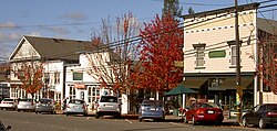
Graton is an unincorporated town and census-designated place (CDP) in west Sonoma County, California, United States. The population was 1,707 at the 2010 census. Graton's ZIP code is 95444. The town also has a culinary reputation attributed to two restaurants in the area. [3]
The town of Graton is roughly 20 miles (32 km) from the California coastline. [4] Graton's agriculture was historically concentrated on apple farming, but like most of rural Sonoma County it now focuses on wine production. [5]
Graton has a total area of 1.58 sq mi (4.1 km2), all land. [6]
Graton is located at the southeastern end of Green Valley, on the east bank of the seasonally flooding Atascadero Creek. The elevation ranges from approximately 85 feet (26 m) above Mean Sea Level (MSL) at Atascadero Creek to 213 feet (65 m) MSL at Oak Grove School.
Graton is noted as lying at the approximate furthest southern and eastern extent of Russian colonization of the Americas. Research on Fort Ross has indicated that several farms were developed inland from the coastal fur trading fort in northwestern Sonoma County. These farms or ranches were used for producing additional food and for agricultural projects conducted by Fort Ross's agronomist Yegor Chernykh. In 1836, a farm was established along Purrington Creek, between what are now the towns of Occidental and Graton. There Chernykh erected barracks and five other structures, and grew vegetables, fruit, wheat, and other grains. Chernykh also developed a large vineyard, introducing what has since become a major crop in the area. [7]
This region experiences warm (but not hot) and dry summers, with no average monthly temperatures above 71.6 °F (22.0 °C). According to the Köppen Climate Classification system, Graton has a warm-summer Mediterranean climate, abbreviated Csb on climate maps. [8]
Climate data for Graton (1991–2020 normals, extremes 1926–present) | |||||||||||||
---|---|---|---|---|---|---|---|---|---|---|---|---|---|
Month | Jan | Feb | Mar | Apr | May | Jun | Jul | Aug | Sep | Oct | Nov | Dec | Year |
Record high °F (°C) | 84 (29) | 88 (31) | 90 (32) | 98 (37) | 103 (39) | 108 (42) | 113 (45) | 108 (42) | 114 (46) | 106 (41) | 92 (33) | 81 (27) | 114 (46) |
Mean maximum °F (°C) | 69.9 (21.1) | 75.8 (24.3) | 80.6 (27.0) | 86.9 (30.5) | 91.0 (32.8) | 98.4 (36.9) | 98.4 (36.9) | 100.4 (38.0) | 100.2 (37.9) | 95.1 (35.1) | 82.5 (28.1) | 70.0 (21.1) | 103.5 (39.7) |
Mean daily maximum °F (°C) | 58.0 (14.4) | 62.3 (16.8) | 65.9 (18.8) | 70.2 (21.2) | 75.2 (24.0) | 81.3 (27.4) | 82.6 (28.1) | 83.8 (28.8) | 83.7 (28.7) | 78.2 (25.7) | 66.8 (19.3) | 57.7 (14.3) | 72.1 (22.3) |
Daily mean °F (°C) | 47.4 (8.6) | 50.2 (10.1) | 52.8 (11.6) | 55.7 (13.2) | 60.4 (15.8) | 64.8 (18.2) | 66.5 (19.2) | 67.1 (19.5) | 65.9 (18.8) | 61.9 (16.6) | 52.8 (11.6) | 46.7 (8.2) | 57.7 (14.3) |
Mean daily minimum °F (°C) | 36.8 (2.7) | 38.0 (3.3) | 39.7 (4.3) | 41.2 (5.1) | 44.5 (6.9) | 48.3 (9.1) | 50.5 (10.3) | 50.3 (10.2) | 48.0 (8.9) | 43.6 (6.4) | 38.7 (3.7) | 35.8 (2.1) | 42.9 (6.1) |
Mean minimum °F (°C) | 26.0 (−3.3) | 27.9 (−2.3) | 30.4 (−0.9) | 32.3 (0.2) | 36.5 (2.5) | 40.1 (4.5) | 42.9 (6.1) | 42.5 (5.8) | 39.1 (3.9) | 33.9 (1.1) | 28.0 (−2.2) | 25.5 (−3.6) | 23.4 (−4.8) |
Record low °F (°C) | 18 (−8) | 17 (−8) | 25 (−4) | 25 (−4) | 29 (−2) | 33 (1) | 38 (3) | 36 (2) | 28 (−2) | 22 (−6) | 22 (−6) | 14 (−10) | 14 (−10) |
Average precipitation inches (mm) | 7.88 (200) | 7.48 (190) | 5.18 (132) | 2.58 (66) | 1.41 (36) | 0.41 (10) | 0.01 (0.25) | 0.06 (1.5) | 0.18 (4.6) | 1.98 (50) | 4.43 (113) | 8.34 (212) | 39.94 (1,014) |
Average precipitation days | 13.2 | 11.8 | 11.1 | 7.3 | 4.1 | 1.5 | 0.4 | 0.8 | 1.5 | 4.2 | 8.8 | 13.2 | 77.9 |
Source: NOAA [9] [10] |
Census | Pop. | Note | %± |
---|---|---|---|
U.S. Decennial Census [11] |
At the 2010 census Graton had a population of 1,707. The population density was 1,080.9 inhabitants per square mile (417.3/km2). The racial makeup of Graton was 1,402 (82.1%) White, 10 (0.6%) African American, 29 (1.7%) Native American, 25 (1.5%) Asian, 3 (0.2%) Pacific Islander, 144 (8.4%) from other races, and 94 (5.5%) from two or more races. Hispanic or Latino of any race were 322 people (18.9%). [12]
The census reported that 99.2% of the population lived in households and 0.8% lived in non-institutionalized group quarters.
There were 680 households, 193 (28.4%) had children under the age of 18 living in them, 304 (44.7%) were opposite-sex married couples living together, 90 (13.2%) had a female householder with no husband present, 19 (2.8%) had a male householder with no wife present. There were 35 (5.1%) unmarried opposite-sex partnerships, and 18 (2.6%) same-sex married couples or partnerships. 188 households (27.6%) were one person and 73 (10.7%) had someone living alone who was 65 or older. The average household size was 2.49. There were 413 families (60.7% of households); the average family size was 3.03.
The age distribution was 343 people (20.1%) under the age of 18, 131 people (7.7%) aged 18 to 24, 352 people (20.6%) aged 25 to 44, 643 people (37.7%) aged 45 to 64, and 238 people (13.9%) who were 65 or older. The median age was 45.9 years. For every 100 females, there were 90.7 males. For every 100 females age 18 and over, there were 86.8 males. The median resident age is 48.2 years, compared to the California average of 36.2 years.
There were 723 housing units at an average density of 457.8 per square mile (176.8/km2), of which 72.2% were owner-occupied and 27.8% were occupied by renters. The homeowner vacancy rate was 0.6%; the rental vacancy rate was 2.6%. 72.0% of the population lived in owner-occupied housing units and 27.2% lived in rental housing units.
The median household income was $83,082 (+70.4% from 2000), and the median family income was $87,641 (+53.9% from 2000). The median per capita income for the CDP was $35,410 (+62.1% from 2000). For comparison, statewide California median per capita income in the 2010 Census was $27,885 (+22.8% from 2000).
At the 2000 census there were 1,815 people, 690 households, and 442 families in the CDP. The population density was 1,162.1 inhabitants per square mile (448.7/km2). There were 706 housing units at an average density of 452.0 per square mile (174.5/km2). The racial makeup of the CDP was 84.35% White, 0.50% African American, 1.49% Native American, 1.10% Asian, 0.06% Pacific Islander, 8.98% from other races, and 3.53% from two or more races. Hispanic or Latino of any race were 19.28%. [6]
Of the 690 households 30.9% had children under the age of 18 living with them, 49.1% were married couples living together, 10.0% had a female householder with no husband present, and 35.9% were non-families. 27.5% of households were one person and 8.8% were one person aged 65 or older. The average household size was 2.60 and the average family size was 3.21.
The age distribution was 24.3% under the age of 18, 8.2% from 18 to 24, 26.0% from 25 to 44, 31.0% from 45 to 64, and 10.5% 65 or older. The median age was 40 years. For every 100 females, there were 97.5 males. For every 100 females age 18 and over, there were 93.8 males.
The median household income was $48,750 and the median family income was $56,944. Males had a median income of $45,179 versus $43,021 for females. The per capita income for the CDP was $21,844. About 4.0% of families and 10.5% of the population were below the poverty line, including 8.1% of those under age 18 and 14.4% of those age 65 or over.
Graton is represented by the following elected officials:
The school districts are Oak Grove Union Elementary School District and West Sonoma County Union High School District. [15]
Fairview is a census-designated place (CDP) in Alameda County, California, United States. It borders on the city of Hayward and the census-designated place of Castro Valley. The population was 11,341 at the 2020 census.
Cobb is a census designated place (CDP) in Lake County, California, United States. Cobb is located 1 mile (1.6 km) northwest of Whispering Pines, at an elevation of 2,631 feet (802 m). The population was 1,778 at the 2010 census, up from 1,638 at the 2000 census.
Valinda is a census-designated place (CDP) in the San Gabriel Valley, in Los Angeles County, California, in the United States. At the 2010 census, the population was 22,822, up from 21,776 at the 2000 census.
West Rancho Dominguez, formerly known as West Compton and also known as East Gardena, is an unincorporated census-designated place (CDP) located in southern Los Angeles County, California. Per the 2020 census, the population was 24,347. The community lies to the west of the city of Compton. The ZIP Codes encompassing the CDP area are 90220 & 90248.
Tamalpais-Homestead Valley is a census-designated place (CDP) in Marin County, California, United States. The population was 11,492 at the 2020 census.
Tomales is a census-designated place (CDP) on State Route 1 in Marin County, California, United States. The population was 187 at the 2020 census.
Lakeview is a census-designated place (CDP) in Riverside County, California, United States. The population was 2,104 at the 2010 census, up from 1,619 at the 2000 census. The community is named for nearby Mystic Lake.
Green Valley is a census-designated place (CDP) located in Solano County, California, United States. It sits in the northeast corner of the San Francisco Bay Area and is located approximately 45 miles (72 km) from Sacramento, approximately 38 miles (61 km) from San Francisco, approximately 32 miles (51 km) from Oakland, less than 15 miles (24 km) from Napa Valley, and less than 15 miles (24 km) from both the Carquinez Bridge and the Benicia Bridge.
Boyes Hot Springs is a census-designated place (CDP) in Sonoma Valley, Sonoma County, California, United States. The population was 6,656 people at the 2010 census. Resorts in Boyes Hot Springs, El Verano, Fetters Hot Springs, and Agua Caliente were popular health retreats for tourists from San Francisco and points beyond until the middle of the 20th century because of the geothermic hot springs that still well up from deep within the Earth.
El Verano is a census-designated place (CDP) in Sonoma Valley, Sonoma County, California, United States. The population was 4,123 at the 2010 census, falling to 3,867 at the 2020 census.
Eldridge is a census-designated place (CDP) in Sonoma County, California, United States. The population was 1,233 at the 2010 census. It is notably the home to the Sonoma Developmental Center, the largest facility serving the needs of persons with developmental disabilities in the state.
Fetters Hot Springs-Agua Caliente is a census-designated place (CDP) in Sonoma Valley, Sonoma County, California, in the United States. As of the 2010 census, the CDP population was 4,144. The name Agua Caliente translates into English, from Spanish, as hot water, referring to the hot springs historically found in the area.
Forestville is a census-designated place (CDP) in Sonoma County, California, United States. It was settled during the late 1860s and was originally spelled Forrestville after one of its founders. The spelling long ago became standardized with one "r". The population was 3,293 at the 2010 census, an increase of nearly 1,000 since the 2000 census.
Glen Ellen is a census-designated place (CDP) in Sonoma Valley, Sonoma County, California, United States. The population was 784 at the 2010 census, down from 992 at the 2000 census. Glen Ellen is the location of Jack London State Historic Park, Sonoma Valley Regional Park, and a former home of Hunter S. Thompson.
Guerneville is an unincorporated community and census-designated place in the Russian River Valley of Sonoma County, California, United States. The town is historically known as a logging community. It was founded by the Guerne family in the 1850s.
Monte Rio is a census-designated place (CDP) in Sonoma County, California along the Russian River near the Pacific Ocean. The town of Guerneville lies northeast of Monte Rio, and Jenner is to the west. The population was 1,152 at the 2010 census, up from 1,104 at the 2000 census. Bohemian Grove is located in Monte Rio.
Occidental is a census-designated place (CDP) in Sonoma County, California, United States. The population was 1,132 at the 2020 census, up from 1,115 at the 2010 census.
Roseland is a neighborhood in Santa Rosa, California. As of the 2010 census, the population was 6,325. Roseland was an unincorporated enclave within the City of Santa Rosa until the area was annexed by Santa Rosa on November 1, 2017.
Temelec is a census-designated place (CDP) in Sonoma County, California, United States. The population was 1,441 at the 2010 census.
Larkfield-Wikiup is a census-designated place unincorporated area in Sonoma County, California, United States. The population was 8,884 at the 2010 census, up from 7,479 at the 2000 census. It comprises the Mark West area between Santa Rosa, Windsor (north), Calistoga (east), and Fulton (west). There are at least four schools within the limits of the CDP, including Cardinal Newman High School, John B. Riebli Elementary School, Mark West Elementary, and San Miguel Elementary schools.