LRT Line 6 (Cavite)

Last updated

LRT Line 6
Overview
StatusProposed [lower-alpha 1]
Owner Light Rail Transit Authority
Locale Cavite
Termini Niog
Governor's Drive
Stations9 [lower-alpha 2]
Service
Type Rapid transit
System Manila Light Rail Transit System
Services5
Rolling stock Electric multiple units
Daily ridership200,000 (2015 estimate)
History
Planned opening2027 (partial)
Technical
Line length23.5 km (14.6 mi) [lower-alpha 3]
Track length47 km (29 mi) [lower-alpha 4]
Number of tracks Double-track
Character Elevated
Track gauge 1,435 mm (4 ft 8+12 in) standard gauge
Minimum radius 50 m (160 ft)
Electrification Overhead line
Operating speed70 km/h (43 mph)
Route map

Contents

BSicon fexhCONTg.svg
BSicon lINTACC-Rq.svg
BSicon fexhKBHFe.svg
BSicon lINTACC-Lq.svg
BSicon exhKBHFa.svg
Niog
ManilaLine1Logo.svg
BSicon exhACC.svg
Bacoor City Hall
BSicon exhACC.svg
San Nicolas
BSicon exhACC.svg
Daang Hari
BSicon exhACC.svg
Alabang
BSicon lGRZaq.svg
BSicon exhSTR+GRZq.svg
BSicon lGRZeq.svg
BSicon exhACC.svg
San Pedro
BSicon exhABZgl.svg
BSicon lhSTRe@gq.svg
BSicon exKDSTeq.svg
San Pedro Depot
BSicon exhACC.svg
La Salle
BSicon exhACC.svg
GMA
BSicon exhKACCe.svg
Governor's Drive

The Light Rail Transit Line 6 is a proposed rapid transit system in Cavite, Philippines. [1] There have been two proposals for the line, with the first one shelved immediately in 2018. [2] Another proposal emerged in 2017 and is currently under review by the National Economic and Development Authority (NEDA).

Background

The province of Cavite is known as a "bedroom community" for those who work in Metro Manila. Over the recent decades, urbanization has been widespread in the country and urban sprawl has been most evident within the Greater Manila Area. The LRT Line 6 aims to provide rail transport options to 45 percent of Cavite's population which are concentrated on the cities of Bacoor, Imus and Dasmariñas. [3]

Early trains in Cavite

Trains belonging to the Manila Railroad Company previously plied the Naic line from Paco station in Manila to Naic station in Naic, Cavite. The commuter rail line was opened in 1909 by the virtue of Insular Government Act No. 1905. [4] It had 19 stations over 44 km (27 mi) of track. There was also a branch line to Cavite City which would have branched off at Noveleta. Some of these trains passed by once towns of Parañaque and Las Piñas in Manila, as well as Bacoor in Cavite. The line ended operation by 1936 and much of the line has been built over in the following decades, such as the expansion of the Nichols Field. Some of the historical right-of-way is now shared between the Colonel Jesus Villamor Air Base and the Ninoy Aquino International Airport. [5] [6]

LRT Line 1 Cavite extension

There were no plans to rebuild a line to Cavite until 2004 when Canadian firm SNC-Lavalin proposed an extension of the existing Line 1 to Cavite. However, the Arroyo administration rejected the study in 2005. [7] In 2012, the LRT Line 1 extension project was announced. It aims to extend the line to Bacoor, Cavite with a target start of construction in 2014 and opening date in mid-2015. [8] However, the bidding process failed and the government repeatedly postponed the project starting in 2013. [9] It was not until 2019 when construction for the LRT Line 1 extension commenced and is currently half-complete as of December 2020. The line in its current form has a targeted partial opening date by 2021 and will be fully-operational by 2024.

First Line 6 proposal

The first mention of a separate LRT Line 6 in Cavite was when then-president Benigno Aquino III approved the construction of the LRT Line 6 in Cavite after a National Economic and Development Authority board meeting on September 6, 2015. [10] The first proposal was described as a 19 km (12 mi) commuter rail line along the route of the Aguinaldo Highway. It will start from Niog station, which is separate from the Line 1 station and the two lines will not share tracks. The next stations will be Tirona, Imus, and Daang Hari stations in Imus; and Salitran, Congressional Avenue, and Governor's Drive in Dasmariñas. [3] This project however was shelved indefinitely in 2018. [2]

Modified Line 6A and 6B+C proposal

In 2018, Villar-led Prime Asset Ventures Inc. came up with an alternative proposal for the said railway line. [11] The new mainline consists of 23.5 km (14.6 mi) long, nine (9) stations, passing through the less congested arterial road of Molino–Paliparan Road, including the large-scale vacant properties in Bacoor and Dasmariñas, Cavite. The new proposal will branch out its railway network in Las Piñas, Muntinlupa, and Parañaque where large-scale subdivisions are situated. As of December 2020, the proposal has passed the stringent qualifications set by the Department of Environment and Natural Resources, prompting to issue an Environmental Compliance Certificate (ECC) on February 7, 2020. [12] The project is now under review by the NEDA-ICC alongside other unsolicited proposals such as the Metro Manila SkyTrain and the MRT Line 10.

Proposed stations

The present Line 6 proposal is 23.5 km (14.6 mi) long, with 9 stations as part of the initial proposal. The main line is so-called Modified Line 6, formerly called Line 6A. It is 23.5 kilometers (14.6 miles) long, starting at Niog station that is connected to the LRT Line 1 Cavite extension and ending at Governor's Drive station. Due to alignment changes, the new Governor's Drive station in Dasmariñas is relocated to Barangay Paliparan, 4.4 kilometers (2.7 miles) east of the original station in Pala-Pala area in Barangay Sampaloc I. [1] There would be also an extension of the line to Tagaytay, although only this section of the line has been presented to the government. [13]

Three stations have been named after locations outside the line's actual right of way: San Pedro, Alabang and GMA. San Pedro being named after the city of San Pedro, Laguna, Alabang after the eponymous barangay in Muntinlupa, and GMA station after the town of General Mariano Alvarez, Cavite. It was however stated in the unsolicited proposal that Alabang Line 6 station is actually located in Barangay Molino IV in Bacoor, while San Pedro will be located in Salawag and GMA in Paliparan IV, both are barangays of Dasmariñas. [1]

NameStructure TypeTransfersLocation
Niog Elevated ManilaLine1Logo.svg Niog Bacoor, Cavite
Bacoor City HallElevatednone
San NicolasEmbankmentAiga bus trans.svg 29  SAMC
Daang HariEmbankmentAiga bus trans.svg 29  SM City Molino
San PedroElevatednone
AlabangEmbankment Dasmariñas, Cavite
La SalleElevated
GMAElevated
Governor's DriveElevatedAiga bus trans.svg 29  Carissa Homes

Expansion

Both the Filipino proponents and the Japanese consultants also included their proposed expanded network to their documents. It includes Line 6B, an airport rail link extension of Line 6 to Ninoy Aquino International Airport; Line 6C, a spur line near the Parañaque–Muntinlupa border; Line 6D, another spur line to Alabang, near the Alabang station of the Philippine National Railways; and the Line 6 extension to Tagaytay. [13] Line 6D is also being developed by the Japanese firm as a separate line. [14] Altogether, the combined line length is at approximately 86 km (53 mi) with a combined track length of around 169 km (105 mi). [1] According to the 2020 Japanese study, the expansion is set to be completed by 2040. [14]

Line 6A Extension

Line 6A was originally planned to expand to Tagaytay near the CaviteBatangas border. Once completed, it will add 18.5 kilometers (11.5 mi) of track to 42 kilometers (26 miles). Tagaytay station will also become the highest point in the Philippine rail network at around 663 m (2,175 ft), higher than the proposed 10 km (6.2 mi) Caraballo Tunnel under the PNR North Long Haul project. [1]

NameStructure TypeTransfersLocation
Governor's DriveElevated 6 Governor's DriveDasmariñas
SilangElevatednone Silang, Cavite
AmadeoElevated Amadeo, Cavite
MendezElevated Mendez, Cavite
TagaytayElevated Tagaytay

Line 6B

Line 6B will run between Ninoy Aquino International Airport in Pasay and San Nicolas Line 6A station in Bacoor, Cavite. The line is 16 kilometers (9.9 miles) long with 10 stations and will have a single track section between NAIA and Sucat Road. [13]

NameStructure TypeTransfersLocation
NAIA Terminal 1Elevated  MMS   NAIA Terminal 1 and 2
Aiga bus trans.svg 23  NAIA Terminal 1
Pasay
SucatElevated 6C Sucat
Aiga bus trans.svg 23  SM City Sucat
Parañaque
CanaynayElevated 6C Canaynay
NagaElevatednone Las Piñas
Daang HariElevated
Alabang-ZapoteElevated
Marcos-AlvarezElevated
ApolloElevated
Queen's RowElevated
San NicolasEmbankment 6 San Nicolas Bacoor, Cavite

Line 6C

Line 6C will run along the right-of-way of Dr. Santos Avenue in Parañaque. A 7.7 km (4.8 mi) 6-station spur of Line 6B, it will split with Line 6B between Canaynay and El Grande stations. While a majority of the area would not have a right-of-way issue for an elevated railway, a two-way ramp leading to the Sucat exit of the Metro Manila Skyway will cause a section of the line leading to Lake Front station to be built as an underpass. [1]

NameStructure TypeTransfersLocation
Sucat (NAIA)Elevated 6B Sucat
Aiga bus trans.svg 23  SM City Sucat
Parañaque
CanaynayElevated 6B Canaynay
El GrandeElevatedAiga bus trans.svg 23  WalterMart Sucat
San AntonioElevatednone
St. JamesElevatedAiga bus trans.svg 23  SM City BF
Lake FrontDepressed Philippine National Railways (PNR).svg  NSCR  Sucat
Aiga bus trans.svg 14  23  25  Sucat
Muntinlupa

Line 6D

Line 6D is connected to Line 6B at Marcos-Alvarez station in Las Piñas. It will be 5 km (3.1 mi) with 4 stations along the Alabang–Zapote Road in Las Piñas and Muntinlupa. This line will have a targeted opening date by 2030. [13]

This branch in particular is also the subject of the Japanese feasibility study published by METI in 2020. Line 6D's Starmall station is located on a vacant lot beside Alabang exit of the South Luzon Expressway. The study also proposed a footbridge connection to the future Alabang station of the North–South Commuter Railway. It is also proposed to be converted into a separate line in the future named the Alabang–Zapote Line. Once this extension is approved, the Alabang–Zapote Line will reach the Cavite Economic Zone in Rosario, Cavite. The total length would also be at 23 kilometers (14 miles). The expansion is targeted to be completed by 2040. [14]

NameStructure TypeTransfersLocation
Marcos AlvarezElevated 6B 
Aiga bus trans.svg 24  SM Southmall
Las Piñas
Town CenterElevatedAiga bus trans.svg 24  Alabang Town Center Muntinlupa
MadrigalElevatednone
StarmallElevated Philippine National Railways (PNR).svg  NSCR  Alabang
Aiga bus trans.svg 14  15  24  25  Alabang

Technical

Rolling stock

The line will use electric multiple units that will be powered through overhead lines, but the type of the rolling stock used remains unspecified. In the 2015 study, Line 6 trains will use 750 V DC electrification, similar to LRT Line 1 as well as some light rail and light rapid transit systems used overseas. The trainsets will also be arranged into a four-car formation reflective of newer-generation light rail vehicles (LRVs) used on Line 1. The use of the term "commuter rail" for the rolling stock made it ambiguous as to whether or not the line will use LRVs or high-capacity trainsets. [15]

In the 2019 proposal, it is also left unspecified as to use LRVs or rapid transit trainsets. An automated guideway transit was also given as an option for Line 6D in the 2020 Japanese study presented by METI. The 2020 study also recommended the use of 4-car trainsets as with the 2015 proposal. The 2020 study also made allowances for coupling two trains into 8-car sets. The maximum passenger capacity of the trainsets is at 300 per car or 1,200 people per set. In comparison, the LRTA 13000 class has a maximum capacity of 1,388 passengers. The use of the AGT, light rail vehicles, or heavy rail trainsets is currently under assessment by NEDA. [14]

Station design

The 2020 study recommends that the line will use island platforms due to its compact size and costs less to construct. The design for the elevated stations will be based on the Yurikamome automated guideway transit system in Tokyo. All elevated stations will feature eki-naka(ja) commercial development. [14] Three stations would be grade-separated by embankment instead of being fully-elevated stations through a viaduct. These are San Nicolas, Daang Hari, and Alabang stations. This is because these stations will be built over private property. [1] Lake Front station of Line 6C will also be built partially underground due to the conflicting pillars of the Metro Manila Skyway Sucat exit ramp. [13] Other than these four stations, the line shall be built with a viaduct.

Line 6 system length

LineStationsLine lengthTrack length
6A923.5 km (14.6 mi)47 km (29 mi)
6A Extension418.5 km (11.5 mi)37 km (23 mi)
6B1016 km (9.9 mi)29 km (18 mi) [lower-alpha 5]
6C67.7 km (4.8 mi) [lower-alpha 6] 15.4 km (9.6 mi)
Alabang–Zapote Line (6D)45 km (3.1 mi)10 km (6.2 mi)
Alabang–Zapote–CEZ Line
(6D Extension)
1518 km (11 mi)36 km (22 mi)
Total4886 km (53 mi)169 km (105 mi)

Notes

  1. The first proposal along the Aguinaldo Highway was cancelled in 2018. A second proposal is currently under review by NEDA.
  2. Up to 48 proposed stations, with only 9 in the main line.
  3. System length is at 86 km (53 mi).
  4. Total track length is at 169 km (105 mi).
  5. An approximated 3 km (1.9 mi) section of the line will be built as single-track.
  6. 2.7 km (1.7 mi) will be shared with line 6B.

Related Research Articles

Cavite Province in Calabarzon, Philippines

Cavite, officially the Province of Cavite, is a province in the Philippines located in the Calabarzon region in Luzon. Located on the southern shores of Manila Bay and southwest of Metro Manila, it is one of the most industrialized and fastest-growing provinces in the Philippines. Its population of 3,678,301 (2015) makes it one of the most populated provinces in the country. Originally agricultural and now a booming bedroom community for ultracongested Metro Manila, its location just north of Taal volcano poses significant risks of ashfall, and debris flows through it into Manila Bay.

South Luzon Expressway Major controlled-access highway in the Philippines

The South Luzon Expressway, formerly known as the South Superhighway (SSH), the Manila South Diversion Road (MSDR), and the Manila South Expressway (MSEX), is a network of two expressways that connects Metro Manila to the provinces of the Calabarzon region on the island of Luzon in the Philippines. The first expressway is a part of Skyway At-Grade, operated jointly by the Skyway Operations and Management Corporation (SOMCO) and SMC Skyway Corporation, running from Makati to Alabang, Muntinlupa. The second expressway, the South Luzon Tollway (SLT) or Alabang–Calamba–Santo Tomas Expressway (ACTEX), is jointly operated by the SMC SLEX, Inc., a joint venture of the Philippine National Construction Corporation and the San Miguel Corporation-backed PT Citra Marga Nusaphala Persada Tbk group of Indonesia via the Manila Toll Expressway Systems, Inc. (MATES), running from Alabang, Muntinlupa to Santo Tomas, Batangas.

Rail transportation in the Philippines Overview of rail transport in the Philippines

Rail transportation in the Philippines is currently used mostly to transport passengers within Metro Manila and the nearby province of Laguna, as well as a commuter service in the Bicol Region. Freight transport services once operated in the country, but these services were halted. However, there are plans to restore old freight services and build new lines.

Manila–Cavite Expressway Road in the Philippines

The Manila–Cavite Expressway, also known as Coastal Road, CAVITEX and R-1 Expressway, is a 14-kilometer-long (8.7 mi) limited-access toll expressway linking Manila to the southern province of Cavite in the Philippines. The entire expressway is designated as Expressway 3 (E3) of the Philippine expressway network and forms part of Radial Road 1 (R-1) of Manila's arterial road network. It is owned and maintained by the Public Estates Authority Tollway Corporation (PEATC), a government corporation and subsidiary of the Public Estates Authority, a government agency under the Office of the President, and is operated by Cavite Infrastructure Corporation, a unit of Philippine-based company Metro Pacific Investments Corporation (MPIC).

EDSA station (LRT)

EDSA station is a station on the Manila Light Rail Transit System Line 1. Like all other stations in the system, EDSA station is above-ground. The station is located on the intersection of Taft Avenue and Epifanio de los Santos Avenue, or EDSA, one of Metro Manila's main thoroughfares. The station was named after EDSA, which in turn is named after Epifanio de los Santos, a noted historian.

Baclaran station

Baclaran station is a station on the Manila Light Rail Transit System Line 1. The station is located on the last stretches of Taft Avenue in Pasay right at the border with Baclaran, Parañaque, and like all other stations on the Line 1, Baclaran terminal is above-ground on viaduct. The terminal is named after the famous shopping district of the same name, which is located on the borders of the cities of Pasay and Parañaque.

LRT Line 1 (Metro Manila) Manila Metro line

The Light Rail Transit Line 1 commonly referred to as LRT Line 1 or LRT-1 is a light rapid transit system line in Metro Manila, Philippines, operated by Light Rail Manila Corporation (LRMC) and owned by the Light Rail Transit Authority (LRTA) as part of the Manila Light Rail Transit System. Currently, the line consists of 20 stations and runs on 19.65 kilometers (12.21 mi) of fully elevated route.

Taft Avenue station

Taft Avenue station is a station on the Manila Metro Rail Transit System Line 3, and is the line's only station in Pasay. The station is located at the corner of Epifanio de los Santos Avenue, or EDSA, one of Metro Manila's main thoroughfares, and Taft Avenue. The station is named after Taft Avenue, which is named after former U.S. President and U.S. Chief Justice William Howard Taft, who served as Governor-General of the Philippines from 1901 to 1903.

Zapote station is an under construction at-grade station on the Manila Light Rail Transit System Line 1. It is part of the Line 1 South Extension Project. The station would be the first Line 1 station outside Metro Manila being located in Bacoor in Cavite. The station will be located near the Zapote Exit Ramp of Manila-Cavite Expressway in Barangay Zapote V (Longos) in Bacoor.

Radial Road 2

Radial Road 2 (R-2), informally known as the R-2 Road, is a network of roads and bridges that all together form the second arterial road of Metro Manila in the Philippines. Spanning some 64.2 kilometers (39.9 mi), it connects the cities and municipalities of Bacoor, Dasmariñas, Imus, Las Piñas, Manila, Parañaque, Pasay, Silang, and Tagaytay in Cavite and Metro Manila.

Niog station is a station under construction on the Manila Light Rail Transit System Line 1 and a proposed station on Line 6. The station will be located on Bacoor Boulevard, about 200 metres away from the intersection with Aguinaldo Highway in Bacoor in Cavite. The closest immediate landmarks to the station are the newly built Hotel Sogo branch which would be right next to the station plot, McDonald's, and St. Dominic Medical Center further down on the corner with Aguinaldo Highway. It is part of the Line 1 South Extension Project, being the final station on the planned extension, while it shall be an intermodal terminal with the Line 6 towards Governor's Drive station.

Dr. Santos Avenue

Dr. Arcadio Santos Avenue or Dr. Santos Avenue, formerly and still referred to as Sucat Road or Parañaque–Sucat Road, is the primary east–west thoroughfare in Parañaque, southern Metro Manila, Philippines. The avenue's western end is in Barangay San Dionisio as the continuation of Ninoy Aquino Avenue. Physically, Ninoy Aquino Avenue connects northbound to NAIA Road in Pasay which, in turn, continues west to Roxas Boulevard back in Parañaque, where it ends. Its eastern end is at the East Service Road, which runs parallel to South Luzon Expressway, in Barangay Sucat, Muntinlupa, where it becomes Meralco Road to service the rest of the route to Sucat railway station.

Alabang–Zapote Road

Alabang–Zapote Road is a four-lane national road which travels east–west through the southern limits of Metro Manila, Philippines. It runs parallel to Dr. Santos Avenue in the north and is named for the two barangays that it links: Alabang in Muntinlupa and Zapote in Las Piñas.

Daang Hari Road in the Philippines

Daang Hari, also known as the Las Piñas–Muntinlupa–Laguna–Cavite Link Road, is a collector road that links southern Metro Manila to the province of Cavite in the Philippines. It begins as a north–south road from Commerce Avenue, just south of the Alabang–Zapote Road running for 5.9 kilometers (3.7 mi) on the boundary of Las Piñas and Muntinlupa. It then runs east–west for about 9.2 kilometers (5.7 mi) from its junction with Daang Reyna, winding through the cities of Bacoor, Imus, Dasmariñas, and General Trias.

PNR Metro Commuter Line Commuter rail line in the Philippines

The PNR Metro Commuter Line is a commuter rail line operated by the Philippine National Railways. It was first inaugurated as the Metro Manila Commuter Service in 1970, and originally served the North Main Line and the South Main Lines, as well as the defunct Carmona and Guadalupe branch lines. Since then, it adopted several names such as Metrotrak and Metrotren, before adopting its present name in the late 2000s. The line is also nicknamed the Orange Line due to its designation in the 1970s.

Index of Metro Manila–related articles Wikipedia index

The following is an alphabetical list of articles related to the Philippine capital region of Metro Manila.

Parañaque Integrated Terminal Exchange Public transport terminal in Manila, Philippines

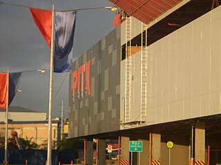
The Parañaque Integrated Terminal Exchange (PITx), formerly called Southwest Integrated Transport System (SWITS), is a public transport terminal in Parañaque, Metro Manila, Philippines. PITx is built and operated by Megawide Construction Corporation and the Department of Transportation (DOTr) under the Philippine government's Public-Private Partnership program.

San Dionisio, Parañaque Barangay in Metro Manila, Philippines

San Dionisio is an administrative division in southern Metro Manila, Philippines. It is a barangay at the southwestern edge of Parañaque and north of its border with Manuyo, Las Piñas. The barangay is centered on the westernmost section of Dr. Santos Avenue where it veers north and parallels Elpidio Quirino Avenue with De Leon Street and Aldana Avenue forming its boundaries with La Huerta and Manuyo Uno respectively. It extends to the east along the San Dionisio River-Villanueva Creek by barangay Moonwalk to the north and along Balong Creek by Manuyo Dos, Las Piñas to the south towards its border with San Isidro. San Dionisio includes a large swath of the C-5 Road South Extension properties in Parañaque including the Amvel Business Park, Avida Sucat and SM City Sucat sites, the Irasan Complex logistics hub, and as well as the area surrounding the Evacom Plaza. It also covers a significant portion of the reclaimed Freedom and Long Islands in the Las Piñas–Parañaque Critical Habitat and Ecotourism Area.

Ninoy Aquino station is a station under construction on the Manila Light Rail Transit System Line 1. It is part of the Line 1 South Extension Project. The station would be built in Ninoy Aquino Avenue in La Huerta, Parañaque.

References

  1. 1 2 3 4 5 6 7 "Project Description for Scoping (Line 6A and 6B/C)" (PDF). eia.emb.gov.ph. Environmental Management Bureau, Department of Environment and Natural Resources. January 31, 2019. Retrieved February 18, 2021.
  2. 1 2 "SBB No. 1-2018". Department of Transportation (Philippines). September 20, 2018. Retrieved December 3, 2018.
  3. 1 2 "LRT Line 6 Project" (PDF). ppp.gov.ph. November 30, 2015. Retrieved February 18, 2021.
  4. "AN ACT GRANTING THE MANILA RAILROAD COMPANY CERTAIN ADDITIONAL CONCESSIONS FOR RAILROAD LINES IN THE ISLAND OF LUZON". Act No. 1905 of May 19, 1909. Philippine Commission.
  5. "Railways of old in Manila and Rizal". www.d0ctrine.com. Retrieved February 18, 2021.
  6. "What if PNR trains reached Naic?". Pariwara. October 13, 2019. Retrieved February 18, 2021.
  7. Valencia, L. B. (September 15, 2004). "LRT1 Extension Expected to Start Construction by 2005". Manila Bulletin.
  8. "Gov't invites investors to bid for LRT-1 extension". Rappler . June 4, 2012. Retrieved February 18, 2021.
  9. Regalado, Cherrie (August 16, 2013). "LRT-1 Cavite extension bidding failed?". Rappler . Retrieved February 18, 2021.
  10. "Aquino OK's 5 big projects". Philippine Daily Inquirer . September 6, 2015. Retrieved February 18, 2021.
  11. "Investment council to decide on 13 unsolicited proposals by 2019 —PPP Center".
  12. "UPDATED LIST OF ENVIRONMENTAL CRITICAL PROJECTS (EPs) WITH ENVIRONMENTAL COMPLIANCE CERTIFICATE (ECC)" (PDF).
  13. 1 2 3 4 5 "LRT6-Executive Summary English" (PDF). Environmental Management Bureau, Department of Environment and Natural Resources. August 15, 2019. Retrieved February 19, 2021.
  14. 1 2 3 4 5 "CAVITE-LAGUNA PUBLIC TRANSPORT MASTER PLAN AND THE PRELIMINARY FEASIBILITY STUDY OF MEDIUM-CAPACITY RAIL SYSTEM IN THE REPUBLIC OF PHILIPPINES" (PDF). Ministry of Economy, Trade and Industry. February 2020. Retrieved February 18, 2021.
  15. "LRT 6 Project Info Memorandum" (PDF). Department of Transportation and Communications. May 2015. Retrieved February 20, 2021.