Al-Hamra, Baysan

Last updated

Contents

Al-Hamra
الحمرا
Etymology: Name of local tribe
Historical map series for the area of al-Hamra, Baysan (1870s).jpg 1870s map
Historical map series for the area of al-Hamra, Baysan (1940s).jpg 1940s map
Historical map series for the area of al-Hamra, Baysan (modern).jpg modern map
Historical map series for the area of al-Hamra, Baysan (1940s with modern overlay).jpg 1940s with modern overlay map
A series of historical maps of the area around Al-Hamra, Baysan (click the buttons)
Mandatory Palestine location map.svg
Red pog.svg
Al-Hamra
Location within Mandatory Palestine
Coordinates: 32°25′40″N35°30′01″E / 32.42778°N 35.50028°E / 32.42778; 35.50028
Palestine grid 196/204
Geopolitical entity Mandatory Palestine
Subdistrict Baysan
Date of depopulationMay 31, 1948
Area
  Total
11,511 [1]   dunams (11.5 km2 or 4.4 sq mi)
Population
 (1945)
  Total
730 [2] [1]

Al-Hamra (Arabic : الحمرا), was a Palestinian Arab village in the District of Baysan. It was located 7.5 kilometres south of Baysan. It was depopulated by the Israeli Army during the 1948 Arab-Israeli War. The village was named after the Bedouin tribe who settled in the village lands centuries ago. [3] The population in 1945 was 730, expanding to 847 in 1948.

In 1945 the village's total land area was recorded as 11,511 dunams, 8,623 of which was Arab owned while 2,153 duname were owned by Jews with the remainder being public property. Al-Hamra was situated 175 meters below sea level. [3]

History

There are archaeological sites located just east of the village that are traced back to the era of the Canaanites, particularly the tells of Abu Kharaj and al-Shuqaf.

Al-Hamra receives its name from the al-Hamra clan, a branch of the al-Suqur ("the Falcons") tribe. According to Walid Khalidi, the al-Hamra clan settled in the area several centuries ago because of its abundant water supplies and fertile soil. The first reference to the village was in 1281 when Qalawun, the Bahri Mamluk sultan, traveled through it on his way to Egypt from Syria. [3] During the rule of Sanjar al-Jawli (Governor of Gaza and much of Palestine from 1311-20 and 1329) he ordered the construction of Khan Salar, a caravansary named after his friend, the former viceroy of the sultanate Emir Salar. [4]

British Mandate era

During the beginning of the 20th-century, al-Hamra's homes were widely scattered and were either permanent adobe brick structures or camel-hair tents. The village's main crops were grain, oranges, olives and vegetables. [3]

In the 1945 statistics, in the British Mandate era, Al-Hamra had a population of 730 Muslims [2] and the total land area was 11,511 dunums. [1] Of this, Arabs used 32 dunams for irrigated areas and plantations, 8,427 was used for cereals, [5] while 733 dunams were uncultivable. [6]

1948, aftermath

No visible structures remained in the village since its depopulation by Israeli forces in 1948. Trees, including fig groves, cacti and grass covered the site when Khalidi visited in the early 1990s. [3]

Related Research Articles

<span class="mw-page-title-main">Arab al-Samniyya</span> Place in Acre, Mandatory Palestine

Arab al-Samniyya, also known as Khirbat al-Suwwana, was a Palestinian village in the Western Galilee that was captured and depopulated by Israel during the 1948 Arab-Israeli war. It was located in the Acre District of the British Mandate of Palestine, 19.5 km northeast of the city of Acre. In 1945 the, village had a population of 200 Arab and a total land area of 1,872 dunums.

<span class="mw-page-title-main">Arab al-'Arida</span> Place in Baysan, Mandatory Palestine

Arab al-'Arida, is a depopulated former Palestinian Arab village and 6 kilometers (3.7 mi) south of the city of Beit She'an.

<span class="mw-page-title-main">Al-Ghazzawiyya</span> Place in Baysan, Mandatory Palestine

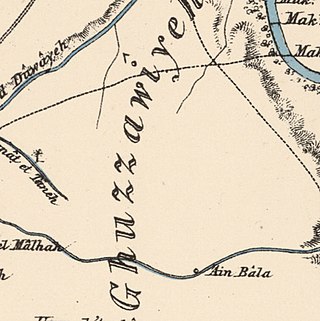
Al-Ghazzawiyya, was a Palestinian village located 2 kilometers east of the city of Bet Shean (Bisan). In 1945, the population was 1,640, 1,020 Arab and 620 Jewish.

<span class="mw-page-title-main">Qumya</span> Village in Baysan, Mandatory Palestine

Qumya, was a Palestinian village of 510 inhabitants when it was depopulated prior to the 1948 Arab-Israeli war.

<span class="mw-page-title-main">Yubla</span> Village in Baysan, Mandatory Palestine

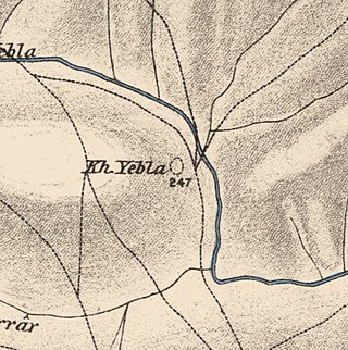
Yubla, was a Palestinian village, located 9 kilometers north of Bisan in present-day Israel. It was depopulated during the 1948 Arab-Israeli war.

<span class="mw-page-title-main">Al-Bira, Baysan</span> Village in Baysan, Mandatory Palestine

Al-Bira, is a depopulated former Palestinian village located 7.5 km north of Baysan. During Operation Gideon, the village was occupied by the Golani Brigade.

<span class="mw-page-title-main">Arab al-Bawati</span> Village in Baysan, Mandatory Palestine

Arab al-Bawati, was a Palestinian Arab village in the District of Baysan. It was depopulated during the 1948 Arab-Israeli War.

<span class="mw-page-title-main">Arab al-Safa</span> Village in Baysan, Mandatory Palestine

Arab al-Safa, was a Palestinian Arab village in the District of Baysan. It was depopulated during the 1948 Arab-Israeli War. It was located 7.5 km south of Baysan.

<span class="mw-page-title-main">Al-Ashrafiyya</span> Place in Baysan, Mandatory Palestine

Al-Ashrafiyya, was a Palestinian Arab village in the District of Baysan. It was depopulated during the 1947–1948 Civil War in Mandatory Palestine. It was located 4.5 km southwest of Baysan.

<span class="mw-page-title-main">Al-Fatur</span> Place in Baysan, Mandatory Palestine

Al-Fatur was a Palestinian Arab village in the District of Baysan. It was depopulated during the 1947–1948 Civil War in Mandatory Palestine on May 12, 1948. It was located 11.5 km south of Baysan. The village was attacked by the Israel Defense Forces as part of Operation Gideon.

<span class="mw-page-title-main">Al-Hamidiyya</span> Place in Baysan, Mandatory Palestine

Al-Hamidiyya, was a Palestinian village in the District of Baysan. It was depopulated by the Jewish militias, precursors of the Israel Defense Forces, during the 1947–1948 Civil War in Mandatory Palestine on May 12, 1948. It was located five kilometres north of Baysan. It was attacked as part of Operation Gideon. The population in 1922 was 193, expanding to 255 in 1948.

<span class="mw-page-title-main">Al-Khunayzir</span> Village in Baysan, Mandatory Palestine

Al-Khunayzir, was a Palestinian Arab village in the District of Baysan. It was depopulated during the 1948 Arab-Israeli War on May 20, 1948.

<span class="mw-page-title-main">Masil al-Jizl</span> Village in Baysan, Mandatory Palestine

Masil al-Jizl was a Palestinian Arab village in the District of Baysan. It was depopulated by the Israel Defense Forces during the Arab-Israeli War. It was attacked and depopulated on May 31, 1948, as part of Operation Gideon.

<span class="mw-page-title-main">Al-Murassas</span> Place in Baysan, Mandatory Palestine

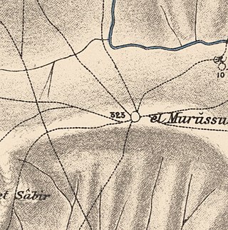
Al-Murassas, was a Palestinian Arab village in the District of Baysan. It was depopulated by the Israel Defense Forces during the 1948 War on May 16, 1948. The village was attacked as part of Operation Gideon.

<span class="mw-page-title-main">Al-Sakhina</span> Place in Baysan, Mandatory Palestine

Al-Sakhina, was a Palestinian Arab village in the District of Baysan. It was located five kilometres west of Baysan on the Jalud River on its way to the Jordan River. It was depopulated by the Israel Defense Forces during the 1947–1948 Civil War in Mandatory Palestine on May 12, 1948, as part of Operation Gideon.

<span class="mw-page-title-main">Al-Samiriyya</span> Village in Baysan, Mandatory Palestine

Al-Samiriyya, was a Palestinian Arab village in the District of Baysan. It was depopulated by the Israel Defense Forces during the 1948 Arab-Israeli War on May 27, 1948, as part of Operation Gideon. It was located 7 km southeast of Baysan.

<span class="mw-page-title-main">Tall al-Shawk</span> Village in Baysan, Mandatory Palestine

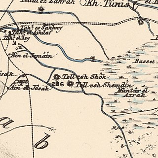
Tall al-Shawk, was a Palestinian village in the District of Baysan. It was depopulated by the Israel Defense Forces during the 1947–1948 Civil War in Mandatory Palestine on May 12, 1948, as part of Operation Gideon. It was located five km west of Baysan between the al-Januna'in River to the north and Wadi al-Jawsaq to the south. The village was built above an ancient archeological site and granite columns remain.

<span class="mw-page-title-main">Al-Tira, Baysan</span> Village in Baysan, Mandatory Palestine

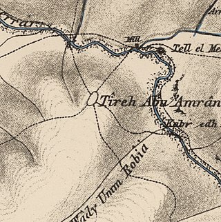
Al-Tira, was a Palestinian Arab village in the District of Baysan. It was depopulated by the Israel Defense Forces during the 1947–48 Civil War in Mandatory Palestine on 15 April 1948 as part of Operation Gideon under the command of Yosef Weitz. It was located 17.5 km north of Baysan overlooking Wadi al-Bira. However, 'Ayn al-Bayda' was the main source of drinking water for al-Tira inhabitants.

<span class="mw-page-title-main">Umm 'Ajra</span> Village in Baysan, Mandatory Palestine

Umm 'Ajra, was a Palestinian Arab village in the District of Baysan. It was depopulated by the Israel Defense Forces during the 1948 Arab-Israeli War on May 31, 1948, as part of Operation Gideon. It was located 4 km south of Baysan and the 'Ayn Umm 'Ajra provided the village with water.

<span class="mw-page-title-main">Zab'a</span> Village in Baysan, Mandatory Palestine

Zab'a, was a Palestinian Arab village in the District of Baysan. It was depopulated by the Israel Defense Forces during the 1947–1948 Civil War in Mandatory Palestine on May 12, 1948, as part of Operation Gideon. It was located 5.5 km northeast of Baysan on Wadi Yubla or Wadi al-'Ashsha.
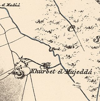
References

  1. 1 2 3 Government of Palestine, Department of Statistics. Village Statistics, April, 1945. Quoted in Hadawi, 1970, p. 43
  2. 1 2 Government of Palestine, Department of Statistics, 1945, p. 6
  3. 1 2 3 4 5 Khalidi, 1992, p. 50
  4. Sharon, 2009, pp. 87-88
  5. Government of Palestine, Department of Statistics. Village Statistics, April, 1945. Quoted in Hadawi, 1970, p. 84
  6. Government of Palestine, Department of Statistics. Village Statistics, April, 1945. Quoted in Hadawi, 1970, p. 134

Bibliography