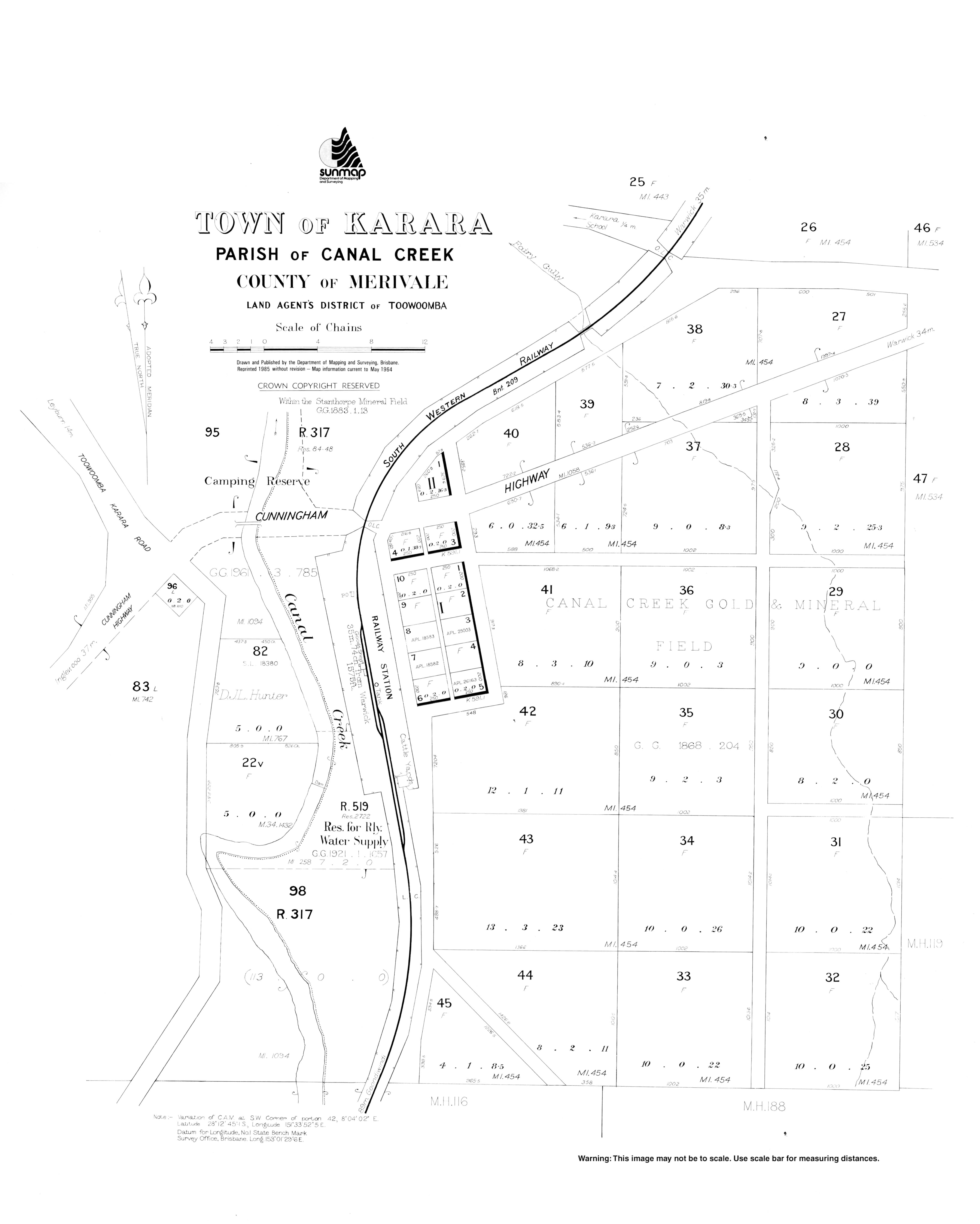
Karara, Queensland

Last updated

Karara
Queensland
KararaStateSchool.JPG
Karara State School
Australia Queensland location map.svg
Red pog.svg
Karara
Coordinates 28°12′29″S151°33′56″E / 28.2080°S 151.5655°E / -28.2080; 151.5655 (Karara (town centre))
Population123 (2016 census) [1]
 • Density0.3483/km2 (0.902/sq mi)
Postcode(s) 4352
Elevation477 m (1,565 ft)
Area353.1 km2 (136.3 sq mi)
Time zone AEST (UTC+10:00)
Location
LGA(s) Southern Downs Region
State electorate(s) Southern Downs
Federal division(s) Maranoa
Localities around Karara:
Stonehenge Leyburn Thanes Creek
Mosquito Creek Karara Thane
Gore Cement Mills Greymare

Karara ( /kərærə/ ) is a rural town and locality in the Southern Downs Region, Queensland, Australia. [2] [3] In the 2016 census, the locality of Karara had a population of 123 people. [1]

Contents

Geography

The town is on the Darling Downs on the Cunningham Highway, 208 kilometres (129 mi) south west of the state capital, Brisbane. The highway passes through the locality from the east to the south-west. The Toowoomba–Karara Road (State Route 48) connects the highway through to the north of the locality to Leyburn and ultimately through to Toowoomba. The South Western railway line passes through the locality roughly parallel and to the north of the highway with the locality served by two railway stations:

Both the line and Karara railway station are no longer in active use. [5]

The Durakai State Forest occupies the southern and eastern areas within the locality; otherwise it is freehold land predominantly used for farming apart from a small urban centre. There are a number of creeks running south to north through the locality which is in the drainage basin of the Condamine River. [5]

History

The name Karara is believed to be an Aboriginal name for Canal Creek. [3]

The South Western railway line from Warwick to Karara was opened in 1904. [6]

Karara State School opened on 20 July 1908. [7] [8]

Karara Post Office opened on 1 July 1927 (a receiving office had been open from 1909) and closed in 1990. [9]

In the 2006 census, Karara and the surrounding area had a population of 140. [10]

In the 2011 census, Karara had a population of 278 people. [11]

In the 2016 census, the locality of Karara had a population of 123 people. [1]

Amenities

The Southern Downs Regional Council operates a mobile library service which visits the Recreation Reserve. [12]

The Karara branch of the Queensland Country Women's Association meets at the Karara Public Hall at 33 School Street. [13]

Education

Karara State School is a government primary (Prep-6) school for boys and girls at Karara School Road ( 28°12′13″S151°33′55″E / 28.2037°S 151.5652°E / -28.2037; 151.5652 (Karara State School) ). [14] [15] In 2017, the school had an enrolment of 5 students with 3 teachers (2 full-time equivalent) and 5 non-teaching staff (1 full-time equivalent). [16] In 2018, the school had an enrolment of 8 students with 2 teachers (1 full-time equivalent) and 5 non-teaching staff (2 full-time equivalent). [17]

There are no secondary schools in Karara. The nearest government secondary schools are Warwick State High School (to Year 12) in Warwick to the east, Inglewood State School (to Year 10) in Inglewood to the south-west, Millmerran State School (to Year 10) in Millmerran to the north-west, Clifton State High School (to Year 12) in Clifton to the north-east, and Allora State School (to Year 10) in Allora to the north-east. [5]

Related Research Articles

<span class="mw-page-title-main">Wallangarra, Queensland</span> Town in Queensland, Australia

Wallangarra is a rural town and locality in the Southern Downs Region, Queensland, Australia on the border with New South Wales. It is the third-most southerly town in Queensland, 258 kilometres (160 mi) south west of Brisbane. Wallangarra is on the Queensland side of the border and Jennings is on the New South Wales side.

<span class="mw-page-title-main">Inglewood, Queensland</span> Town in Queensland, Australia

Inglewood is a rural town and locality in the Goondiwindi Region, Queensland, Australia. In the 2016 census, the locality of Inglewood had a population of 954 people, making Inglewood the second largest town in the Goondiwindi Region.

<span class="mw-page-title-main">Nobby, Queensland</span> Town in Queensland, Australia

Nobby is a rural town and locality on the Darling Downs in the Toowoomba Region, Queensland, Australia. It is located halfway between Toowoomba and Warwick. It is known for its association with Steele Rudd (author) and Sister Elizabeth Kenny.

<span class="mw-page-title-main">Allora, Queensland</span> Town in Queensland, Australia

Allora is a rural town and locality in the Southern Downs Region, Queensland, Australia. In the 2016 census, the locality of Allora had a population of 1,223 people.

<span class="mw-page-title-main">Millmerran, Queensland</span> Town in Queensland, Australia

Millmerran, known as Domville between 1 June 1889 and 16 November 1894, is a town and a locality in the Toowoomba Region, Queensland, Australia. In the 2016 census, the locality of Millmerran had a population of 1,563 people.

<span class="mw-page-title-main">Leyburn, Queensland</span> Town in Queensland, Australia

Leyburn is a rural town in the Southern Downs Region and a locality split between the South Downs Region and the Toowoomba Region in Queensland, Australia. In the 2016 census, Leyburn had a population of 476 people.

<span class="mw-page-title-main">Maryvale, Queensland (Southern Downs Region)</span> Town in Queensland, Australia

Maryvale is a rural town and locality in the Southern Downs Region, Queensland, Australia. In the 2016 census, the locality of Maryvale had a population of 303 people.

<span class="mw-page-title-main">Dalveen, Queensland</span> Town in Queensland, Australia

Dalveen is a town and a locality in the Southern Downs Region, Queensland, Australia. It borders New South Wales. In the 2016 census, Dalveen had a population of 335 people.

<span class="mw-page-title-main">Yangan, Queensland</span> Town in Queensland, Australia

Yangan is a rural town and locality in the Southern Downs Region, Queensland, Australia. In the 2021 census, the locality of Yangan had a population of 404 people.

<span class="mw-page-title-main">Allan, Queensland</span> Suburb of Southern Downs Region, Queensland, Australia

Allan is a rural locality in the Southern Downs Region, Queensland, Australia. It was formerly known as Sandy Creek. In the 2021 census, Allan had a population of 91 people.

<span class="mw-page-title-main">Pampas, Queensland</span> Suburb of Toowoomba Region, Queensland, Australia

Pampas is a rural locality in the Toowoomba Region, Queensland, Australia. In the 2021 census, Pampas had a population of 78 people.

<span class="mw-page-title-main">The Summit, Queensland</span> Town in Queensland, Australia

The Summit is a rural town and locality in the Southern Downs Region, Queensland, Australia. In the 2016 census, the locality of The Summit had a population of 409 people.

<span class="mw-page-title-main">Mount Marshall, Queensland</span> Suburb of Southern Downs Region, Queensland, Australia

Mount Marshall is a rural locality in the Southern Downs Region, Queensland, Australia. In the 2021 census, Mount Marshall had a population of 229 people.

Mosquito Creek is a rural locality in the Goondiwindi Region, Queensland, Australia. In the 2021 census, Mosquito Creek had a population of 8 people.

Glen Aplin is a rural locality in the Southern Downs Region, Queensland, Australia. In the 2021 census, Glen Aplin had a population of 566 people.

<span class="mw-page-title-main">Clintonvale, Queensland</span> Suburb of Southern Downs Region, Queensland, Australia

Clintonvale is a rural locality in the Southern Downs Region, Queensland, Australia. In the 2021 census, Clintonvale had a population of 72 people.

<span class="mw-page-title-main">Thane, Queensland</span> Town in Queensland, Australia

Thane is a rural town and locality in the Southern Downs Region, Queensland, Australia. In the 2016 census, Thane had a population of 27 people.

<span class="mw-page-title-main">Massie, Queensland</span> Suburb of Southern Downs Region, Queensland, Australia

Massie is a rural locality in the Southern Downs Region, Queensland, Australia. In the 2021 census, Massie had a population of 113 people.

<span class="mw-page-title-main">Victoria Hill, Queensland</span> Suburb of Southern Downs Region, Queensland, Australia

Victoria Hill is a rural locality spit between the Southern Downs Region and the Toowoomba Region, both in Queensland, Australia. In the 2021 census, Victoria Hill had a population of 48 people.

<span class="mw-page-title-main">Silverwood, Queensland</span> Suburb of Southern Downs Region, Queensland, Australia

Silverwood is a rural locality in the Southern Downs Region, Queensland, Australia. In the 2021 census, Silverwood had a population of 58 people.

References

  1. 1 2 3 Australian Bureau of Statistics (27 June 2017). "Karara (SSC)". 2016 Census QuickStats. Retrieved 20 October 2018. OOjs UI icon edit-ltr-progressive.svg
  2. "Karara – town in Southern Downs Region (entry 17738)". Queensland Place Names. Queensland Government . Retrieved 14 August 2022.
  3. 1 2 "Karara – locality in Southern Downs Region (entry 45942)". Queensland Place Names. Queensland Government . Retrieved 14 August 2022.
  4. 1 2 "Railway stations and sidings - Queensland". Queensland Open Data. Queensland Government. 2 October 2020. Archived from the original on 5 October 2020. Retrieved 5 October 2020.
  5. 1 2 3 "Queensland Globe". State of Queensland . Retrieved 28 August 2022.
  6. "Southern Downs Region". Queensland Places. Centre for the Government of Queensland, University of Queensland. Retrieved 12 July 2015.[ permanent dead link ]
  7. "Opening and closing dates of Queensland Schools". Queensland Government . Retrieved 12 July 2015.
  8. "Karara SS" . Retrieved 30 January 2017.
  9. Premier Postal History. "Post Office List". Premier Postal Auctions. Retrieved 10 May 2014.
  10. Australian Bureau of Statistics (25 October 2007). "Karara (Warwick Shire) (State Suburb)". 2006 Census QuickStats. Retrieved 19 January 2009.
  11. Australian Bureau of Statistics (31 October 2012). "Karara". 2011 Census QuickStats. Retrieved 12 July 2015. OOjs UI icon edit-ltr-progressive.svg
  12. "Library Details". Southern Downs Regional Council . Archived from the original on 31 January 2018. Retrieved 31 January 2018.
  13. "Branch locations". Queensland Country Women's Association . Archived from the original on 26 December 2018. Retrieved 26 December 2018.
  14. "State and non-state school details". Queensland Government. 9 July 2018. Archived from the original on 21 November 2018. Retrieved 21 November 2018.
  15. "Karara State School". Karara State School. 6 March 2019. Retrieved 28 August 2022.
  16. "ACARA School Profile 2017". Archived from the original on 22 November 2018. Retrieved 22 November 2018.
  17. "ACARA School Profile 2018". Australian Curriculum, Assessment and Reporting Authority . Retrieved 28 January 2020.