Related Research Articles

Thyagaraya Nagar, commonly known as T. Nagar, is a very affluent commercial and residential neighbourhood in Chennai, Tamil Nadu, India. It is surrounded by Nungambakkam in the North, Teynampet in the East, Nandanam in the South-East, C.I.T. Nagar in the South and West Mambalam and Kodambakkam in the West. The stretch between Duraiswamy Road and T. Nagar Bus Stand has some of the costliest real estates in Chennai. It was constructed between 1923 and 1925 by the Madras Presidency government of the Raja of Panagal as a part of town planning activities initiated according to the Madras Town Planning Act of 1920. The town was named after P. Thyagaraya Chetty. The streets, parks and localities in the new neighbourhood were named after important officials in the provincial government.

Kotturpuram, also known as Kottur, is a neighbourhood in Chennai (Madras), Tamil Nadu, India and is situated in the Southern banks of the Adyar River. It is surrounded by Nandanam in the North and North-West, Adyar in the South-East, IIT Chennai and Guindy in the South and Little Mount in the South-West. The neighbourhood is served by Kotturpuram MRTS railway station. Centuries old Hindu temples, such as Perumal Koil and Ponniamman Koil are situated in Kottur.

Kumaran Kundram is a hillrock located at Chromepet, Chennai, Tamilnadu, India. It houses an about 40-year-old temple dedicated to the Hindu God Murugan. The temple can be reached by road from Chromepet en route to Hasthinapuram. The presiding deity is Sri Swaminathaswamy. The presiding deity in Kumaran Kundram is believed to be equivalent to the one in Swamimalai and stands atop the hillock facing north. It can be reached by a flight of about 80 steps.

Velachery is a commercial and residential area in south Chennai, and is the largest commercial centre in south Chennai. It is surrounded by Guindy in the north, IIT Madras in the north-east, Taramani in the east, Perungudi in the south-east, Pallikaranai Wetland in the south, also Madipakkam in the south and south-west, Adambakkam in the west and north-west. The growth of the neighbourhood during the last decade can be cited due to the growth of the IT sector in south Chennai. It acts as an important hub connecting the rapidly growing business-class information technology corridor popularly called the OMR; the more mature and well-connected GST road and the central business districts of the city, which has more relevance to the history of Chennai. Velachery as a whole draws a perfect balance between old and new Chennai and is a phenomenon in terms of growth and development.

Saidapet, also known as Saidai, is a neighbourhood in Chennai, India, situated in the northern banks of the Adyar River and serves as an entry point to Central Chennai. It is surrounded by West Mambalam in the North, C.I.T Nagar in the North-East, Nandanam in the East, Guindy in the South, Jafferkhanpet and Ashok Nagar in the North-West. The Saidapet Court, the only other court of judicature in Chennai city apart from the Madras High Court, and the Saidapet bus depot are located here. Prior to its incorporation in Madras city, Saidapet functioned as the administrative headquarters of Chingleput district. The neighbourhood is served by Saidapet railway station of the Chennai Suburban Railway Network.

Ranganathan Street is a major commercial street in the neighborhood of T. Nagar, located in Chennai, India. It is one of the most crowded streets in Chennai. The street houses several commercial establishments, primarily those involved in the clothing and jewelry industry. It has often been referred to as the most crowded street in Chennai.

West Mambalam is a residential and commercial area in Chennai, India. It is known for its shops, bazaars and Hindu temples. It is bounded by Kodambakkam to the north and Saidapet to the south. T. Nagar and Nandanam stretch all along its eastern frontiers while Ashok Nagar lies to its west. The Ayodhya Mandapam is an important landmark.
Ashok Nagar is a residential locality situated at the southern part of Chennai, Tamil Nadu, India. It was established in 1964. At the heart of this colony, stands the Ashok Pillar. This four lion head stump, resembles the one erected by king Ashoka during the 3rd century BC at Sanchi.
The Chennai Metropolitan Development Authority (CMDA), formerly known as the Madras Metropolitan Development Authority (MMDA), is the nodal planning agency of Chennai in the Indian state of Tamil Nadu. The CMDA administers the Chennai Metropolitan Region, spread over an area of 1,189 km2 (459 sq mi) and covers the districts of Chennai, Thiruvallur, Chengalpattu and Kancheepuram. It was set up for the purposes of planning, co-ordination, supervising, promoting and securing the planned development of the Chennai Metropolitan Area. It coordinates the development activities of the municipal corporations, municipalities and other local authorities.

Panagal Park is a park and a locality in Theagaraya Nagar, Chennai. The park is named after the Raja of Panagal, the Chief Minister of Madras Presidency who created the park. It is an important junction and is the commercial centre of T Nagar.
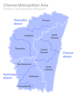
The Greater Chennai Metropolitan Area, or simply the Chennai Metropolitan Area (CMA), is the fourth-most populous metropolitan area in India, the 22nd-most in Asia, and the 40th-most in the world. The CMA consists of the core city of Chennai, which is coterminous with the Chennai district, and its suburbs in Kanchipuram, Chengalpattu, and Thiruvallur districts. The Chennai Metropolitan Development Authority (CMDA) is the nodal agency that handles town planning and development within the metro area. Since 1974, an area encompassing 1,189 km2 around the city has been designated as the CMA and the CMDA has been designated as the authority to plan the growth of the city and the area around it.

Chennai is located at 13.04°N 80.17°E on the southeast coast of India and in the northeast corner of Tamil Nadu. It is located on a flat coastal plain known as the Eastern Coastal Plains. The city has an average elevation of 6 metres (20 ft), its highest point being 60 m (200 ft).
Kasi Viswanatha Temple may refer to:
Kasi Viswanatha Temple is a Hindu temple located in the neighbourhood of West Mambalam in Chennai, India. Dedicated to Siva, the temple is named after the Vishwanatha Temple at Varanasi. Constructed in the 17th century, the temple is also known as "Mahabilva Kshetra".
Madras Kali Bari is a Hindu temple located in the neighbourhood of West Mambalam in Chennai, India. Dedicated to the goddess Kali, the temple is constructed on the lines of the Dakhshineshwar Kali temple near Kolkata by the Bengali community in the city. Within the precincts of the temple, is a meditation hall where bhajans are sung daily. Bengali festivals like Durga Puja and Kali Puja are celebrated with grandeur.

Mambalam Railway Station is one of the railway stations in Chennai, India, on the Chennai Beach–Chengelpet section of the Chennai Suburban Railway Network. It serves the neighbourhoods of West Mambalam and T. Nagar. It is situated between the two neighbourhoods, about 11 km (6.8 mi) from Chennai Beach, and has an elevation of 13 m (43 ft) above sea level.
Chennai remains the chief retail industry and shopping centre in South India, with some of its suburbs serving as exclusive shopping districts. Since the formation of the city in the seventeenth century, George Town remains one of the chief commercial neighbourhood of the city. However, with the centuries passing, the central business district of the city started shifting towards the south of Fort St. George and moving to its present location at Gemini Circle. The city's retail industry is concentrated chiefly in T. Nagar, which is by far the largest shopping district of India, generating more than twice the revenue of Connaught Place in New Delhi or Linking Road in Mumbai, even by conservative estimates.
Ashok Nagar Metro station is a Metro railway station on the Line 2 of the Chennai Metro, which is currently under operation. The station is among the elevated stations coming up along corridor II of the Chennai Metro, Chennai Central–St. Thomas Mount stretch. The station will serve the neighbourhoods of Ashok Nagar and Mambalam.

Kodambakkam is a business and residential neighbourhood in Central Chennai formerly Madras, Tamil Nadu, India. The neighbourhood is served by Kodambakkam railway station of the Chennai Suburban Railway Network. Kodambakkam has a high concentration of film studios and has been known for its status as the hub of the Tamil film industry, lending its name to the industry's monicker Kollywood.
Ambattur division is a revenue division in the Chennai district of Tamil Nadu, India. It comprises the taluks of Ambattur, Aminjikarai, Ayanavaram, Egmore, Maduravoyal and Mambalam.
References
- S. Muthiah, ed. (2008). Madras, Chennai: A 400-year record of the first city of Modern India. 1. Palaniappa Brothers. p. 105.
| Temples |
|
|---|---|
| Churches |
|
| Mosques | |
| Jain temples | |
| Buddhist temples | |
| Gurudwaras | |
| Parsi temples | |