Al-Mazar, Haifa

Last updated

Contents

Al-Mazar
المزار
Village
Historical map series for the area of Al-Mazar, Haifa (1870s).jpg 1870s map
Historical map series for the area of Al-Mazar, Haifa (1940s).jpg 1940s map
Historical map series for the area of Al-Mazar, Haifa (modern).jpg modern map
Historical map series for the area of Al-Mazar, Haifa (1940s with modern overlay).jpg 1940s with modern overlay map
A series of historical maps of the area around Al-Mazar, Haifa (click the buttons)
Mandatory Palestine location map.svg
Red pog.svg
Al-Mazar
Location within Mandatory Palestine
Coordinates: 32°40′56″N34°57′52″E / 32.68222°N 34.96444°E / 32.68222; 34.96444
Palestine grid 147/232
Geopolitical entity Mandatory Palestine
Subdistrict Haifa
Date of depopulationJuly 15, 1948 [1]
Population
 (1945)
  Total
210 [2]
Cause(s) of depopulationMilitary assault by Yishuv forces
Current Localities Ein Carmel

Al-Mazar was a Palestinian Arab village located 4 kilometers (2.5 mi) northeast of al-Sarafand. [3] In 1945, it had a population of 210.

History

The village name Mazar , which is Arabic for "shrine", "a place one visits", was probably meant to commemorate the many people who were killed and buried there in the wars against the Crusaders. [4]

A population list from about 1887 showed that el Mizar had about 85 inhabitants; all Muslims. [5]

British Mandate period

In the British Mandate of Palestine period, in the 1922 census of Palestine ‘’Al Mazar’’ had a population of 134; all Muslims. [6] In the 1931 census, Al-Mazar was counted together with Khirbat Al-Manara, Ijzim and Qumbaza. The total population was 2,160; 88 Christians, 2,082 Muslims, in a total of 442 houses. [7]

In the 1945 statistics the population was 210, all Muslims [2] with a total of 7,976 dunams of land. [8] Of this, 5 dunams were for citrus and bananas, 473 were plantations or irrigable land, 3,750 were for cereals, [9] while 39 dunams were classified built-up, (urban), land. [10]

Al-Mazar (El Mazar) 1932 1:20,000 Atlit 1932.jpg
Al-Mazar (El Mazar) 1932 1:20,000
Al-Mazar (Mazar) 1945 1:20,000 Jaba 1945.jpg
Al-Mazar (Mazar) 1945 1:20,000

1948 and aftermath

The village was first raided by the Israel Forces (IDF) on May 17 during the 1948 Arab-Israeli war, with the aim of "rendering [the village] unworthy of use." [3] The IDF encountered only 10-20 Arabs, who ran away, and the troops proceeded to "burn what could be burned." [3] Within days of the IDF's withdrawal, some of the villagers had returned, Arab militants and civilians. [3] [11] The village was permanently depopulated as a result of another IDF military assault in mid-July 1948. [11] Following the war the area was incorporated into the State of Israel and the kibbutz of Ein Carmel was established partially on al-Mazar's land in 1950.[ citation needed ]

Shaykh Yahia/Ahya shrine

The Maqam (shrine) was located on the lower slopes of a hill. [12] In 1881, E. H. Palmer described the name as possibly coming from St. John of Tyre, who was noted in this direction in 1187. [13] Ahya is also a name for John the Baptist. [14]

The shrine was surveyed by Ronen and Olami in 1964–65. They found a two roomed structure, facing east–west. The eastern room seemed the oldest; it was a domed rectangular room made of kurkar stone, where the surface were coated with plaster containing Byzantine pottery fragments. The western room was built of limestone. [15]

The shrine has now been destroyed, and the area has been converted into orchards. [12]

Related Research Articles

<span class="mw-page-title-main">Al-Nabi Rubin, Acre</span> Place in Acre, Mandatory Palestine

Al-Nabi Rubin, was a Palestinian village located 28 kilometers northeast of Acre. Al-Nabi Rubin students used to attend school in the nearby village of Tarbikha.

<span class="mw-page-title-main">Al-Jura</span> Place in Gaza, Mandatory Palestine

Al-Jura was a Palestinian village that was depopulated during the 1948 Arab-Israeli war, located immediately adjacent to the towns of Ashkelon and the ruins of ancient Ascalon. In 1945, the village had a population of approximately 2,420 mostly Muslim inhabitants. Though defended by the Egyptian Army, al-Jura was nevertheless captured by Israel's Givati Brigade in a November 4, 1948, offensive as part of Operation Yoav.

<span class="mw-page-title-main">Indur</span> Village in Nazareth, Mandatory Palestine

Indur was a Palestinian village, located 10.5 kilometres (6.5 mi) southeast of Nazareth. Its name preserves that of ancient Endor, a Canaanite city state thought to have been located 1 kilometre (0.62 mi) to the northeast. The village was depopulated during the 1948 Arab–Israeli War and its inhabitants became refugees, some of whom were internally displaced. In Israel today, there are a few thousand internally displaced Palestinians who hail from Indur, and continue to demand their right of return.

<span class="mw-page-title-main">Nasir ad-Din, Palestine</span> Village in Tiberias, Mandatory Palestine

Nasir ad-Dīn was a small Palestinian Arab village 3 kilometers (1.9 mi) southwest of Tiberias, on the crest of a slope that overlooks the Sea of Galilee. The village had several springs to the east, south, and southeast. In the 1931 British census 179 people lived there, decreasing to 90 in a 1945 census. Nasir ad-Din and nearby al-Manara were in the same jurisdiction with 4,185 dunams of land, most of which was allocated to cereals.

<span class="mw-page-title-main">Bayt Jiz</span> Place in Ramle, Mandatory Palestine

Bayt Jiz was a Palestinian Arab village situated on undulating land in the western foothills of the Jerusalem heights, 15 kilometers (9.3 mi) southwest of Ramla. In 1945, it had a population of 550. It was occupied by Israeli forces in the 1948 Arab–Israeli War and became depopulated.

<span class="mw-page-title-main">Al-Nabi Yusha'</span> Village in Safad, Mandatory Palestine

Al-Nabi Yusha' was a small Palestinian village in the Galilee situated 17 kilometers to the northeast of Safad, with an elevation of 375 meters above sea level. It became part of the Palestine Mandate under British control from 1923 until 1948, when it was depopulated during the 1948 Arab-Israeli War. The village was surrounded by forest land overlooking the Hula Valley.

<span class="mw-page-title-main">Arab al-Bawati</span> Village in Baysan, Mandatory Palestine

Arab al-Bawati, was a Palestinian Arab village in the District of Baysan. It was depopulated during the 1948 Arab-Israeli War.

<span class="mw-page-title-main">Al-Khunayzir</span> Village in Baysan, Mandatory Palestine

Al-Khunayzir, was a Palestinian Arab village in the District of Baysan. It was depopulated during the 1948 Arab-Israeli War on May 20, 1948.

<span class="mw-page-title-main">Bil'in, Gaza</span> Village in Gaza, Mandatory Palestine

Bil'in was a Palestinian Arab village in the Gaza Subdistrict. It was depopulated by the Israel Defense Forces during the 1948 Arab–Israeli War on July 8, 1948, under Operation An-Far. It was located 39 km northeast of Gaza and the village contained two wells which supplied it with drinking water.

<span class="mw-page-title-main">Khirbat Al-Dumun</span> Place in Haifa, Mandatory Palestine

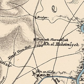
Al-Dumun was a Palestinian Arab village in the Haifa Subdistrict. It was depopulated during the 1947–1948 Civil War in Mandatory Palestine on April 30, 1948. It was located 10.5 km southeast of Haifa.

<span class="mw-page-title-main">Umm ash Shauf</span> Village in Haifa, Mandatory Palestine

Umm al-Shawf or Umm ash Shauf was a Palestinian Arab village located 29.5 km south of Haifa, on the sloping section of Wadi al-Marah. It was depopulated as a result of a military assault between May 12–14, just before the outbreak of the 1948 Arab-Israeli war.

<span class="mw-page-title-main">Al-Qabu</span> Place in Jerusalem, Mandatory Palestine

Al-Qabu was a Palestinian Arab village in the Jerusalem Subdistrict. The name is an Arabic variation of the site's original Roman name, and the ruins of a church there are thought to date to the era of Byzantine or Crusader rule over Palestine.

<span class="mw-page-title-main">Sataf</span> Village in Jerusalem, Mandatory Palestine

Sataf was a Palestinian village in the Jerusalem Subdistrict depopulated during the 1948 Arab–Israeli War. It was located 10 km west of Jerusalem, with Sorek Valley bordering to the east.

<span class="mw-page-title-main">Dayr Abu Salama</span> Village in Ramle, Mandatory Palestine

Dayr Abu Salama was a small Palestinian Arab village in the Ramle Subdistrict, located 8 km northeast of Ramla. It was depopulated during the 1948 Arab–Israeli War on July 13, 1948, in the first phase of Operation Dani.

<span class="mw-page-title-main">Al-'Abisiyya</span> Village in Safad, Mandatory Palestine

Al-'Abisiyya was a Palestinian Arab village in the District of Safad. It was depopulated during the 1948 Arab-Israeli War on May 29, 1948, by The Palmach's First Battalion of Operation Yiftach. It was located 28.5 km northeast of Safad near to the Banyas River which the village relied on for irrigation.

<span class="mw-page-title-main">Ghabbatiyya</span> Village in Safad, Mandatory Palestine

Ghabbatiyya was a Palestinian Arab hamlet in the Safad Subdistrict. It was depopulated during the 1948 Arab-Israeli War on October 30, 1948, under Operation Hiram. It was located 12 km northwest of Safad.

<span class="mw-page-title-main">Al-Shawka al-Tahta</span> Place in Safad, Mandatory Palestine

Al-Shawka al-Tahta was a Palestinian Arab village in the Safad Subdistrict. It was depopulated during the 1947–1948 Civil War in Mandatory Palestine on May 14, 1948, by the Palmach's First Battalion of Operation Yiftach. It was located 31.5 km northeast of Safad.

<span class="mw-page-title-main">Al-Na'ima</span> Place in Safad, Mandatory Palestine

Al-Na'ima was a Palestinian Arab village in the Safad Subdistrict of Mandatory Palestine located 26 kilometres (16 mi) northeast of Safad, near the al-Hula Plain. The settlement was depopulated during the 1947-1948 civil war on May 14, 1948 by the Israeli Palmach's First Battalion as part of Operation Yiftach.

<span class="mw-page-title-main">Al-Qudayriyya</span> Village in Safad, Mandatory Palestine

Al-Qudayriyya was a Palestinian Arab village in the Safad Subdistrict. It was depopulated during the 1947–1948 Civil War in Mandatory Palestine on May 4, 1948, by the Haganah and the Palmach's First Battalion of Operation Matate, a sub-operation of Operation Yiftach. It was located 6.5 km south of Safad, situated 1 km east of Wadi al-'Amud.

<span class="mw-page-title-main">Al-Mazar, Jenin</span> Village in Jenin, Mandatory Palestine

Al-Mazar was a Palestinian Arab village in the District of Jenin. Situated on Mount Gilboa, its history stretched back to the period of Mamluk rule over Palestine. An agricultural village, its villagers traced their ancestry to nomads descended from a Sufi mystic from Jaba', Syria.

References

  1. Morris, 2004, p. xviii, village #169. Also gives cause of depopulation
  2. 1 2 Government of Palestine, Department of Statistics, 1945, p. 14
  3. 1 2 3 4 Morris, 2004, p. 248
  4. Khalidi, 1992, p.178
  5. Schumacher, 1888, p. 178
  6. Barron, 1923, Table XI, Sub-district of Haifa, p. 33
  7. Mills, 1932, p. 91
  8. Government of Palestine, Department of Statistics. Village Statistics, April, 1945. Quoted in Hadawi, 1970, p. 48
  9. Government of Palestine, Department of Statistics. Village Statistics, April, 1945. Quoted in Hadawi, 1970, p. 91
  10. Government of Palestine, Department of Statistics. Village Statistics, April, 1945. Quoted in Hadawi, 1970, p. 141
  11. 1 2 Morris, 2004, p. 438
  12. 1 2 Petersen, 2001, p. 216
  13. de Vogüé, 1860, p. 445; as noted in Palmer, 1881, p. 116
  14. Palmer, 1881, p. 116
  15. Ronen and Olami, 1978, as given in Petersen, 2001, p. 216

Bibliography