
Hatta was a Palestinian Arab village of 1,125 inhabitants that was depopulated after a July 17, 1948 assault by Israeli forces of the Givati Brigade during the 1948 Arab-Israeli war. Following the war the area was incorporated into the State of Israel and Zavdiel and Aluma were established on the land that had belonged to Hatta.

Kudna was a Palestinian Arab village, located 25 kilometers northwest of Hebron.

Ra'na was a village located approximately 26 km northwest of Hebron. It was occupied by the Israeli army during Operation Yo'av in October 1948. It was one of 16 villages in the Hebron district that were depopulated.

Qastina was a Palestinian village, located 38 kilometers northeast of Gaza City. It was ethnically cleansed during the 1948 Arab-Israeli war.

Deir al-Dubban was a small Palestinian village 26 kilometers (16 mi) northwest of Hebron, near the modern village of Luzit, between Jerusalem, and Ashkelon. The village was depopulated in the 1948 Palestine War.

Dimra was a small Arab village located 11 kilometres (6.8 mi) northeast of Gaza City in British Palestine. Ancient remains at the site attest to a long-time human settlement there; during the Mamluk era, the town was the home of the Bani Jabir tribe. It was depopulated during the 1948 Arab–Israeli War, and is now the site of Erez, a kibbutz in Israel.

Dayr Sunayd was a Palestinian Arab village in the Gaza Subdistrict, located 12 kilometers (7.5 mi) northeast of Gaza. Situated at an elevation of 50 meters (160 ft) along the southern coastal plain of Palestine, Deir Sunayd had a total land area of 6,081 dunams. Prior to its depopulation during the 1948 Arab–Israeli War, it had 730 inhabitants in 1945.

Al-Sawafir al-Shamaliyya was a Palestinian Arab village in the Gaza Subdistrict, located 33 kilometers (21 mi) northeast of Gaza situated along the southern coastal plain of Palestine 50 meters (160 ft) above sea level. It was one of three namesake villages, alongside Al-Sawafir al-Sharqiyya and Al-Sawafir al-Gharbiyya.

Summil was a Palestinian Arab village in the Gaza Subdistrict, located 36 kilometers (22 mi) northeast of Gaza. It was situated on a sandy hill in the coastal plain and had a population of 950 in 1945. It was depopulated during the 1948 Arab-Israeli War.

Tall al-Turmus was a Palestinian Arab village in the Gaza Subdistrict, located on a low hill on the coastal plain of Palestine, 38 kilometers (24 mi) northeast of Gaza. In 1945, it had a population of 760 and a land area of 11,508 dunams. The village was depopulated during the 1948 Arab-Israeli War.
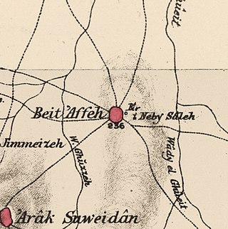
Bayt 'Affa was a Palestinian village in the Gaza Subdistrict. It was depopulated and destroyed during the 1947–48 Civil War in Mandatory Palestine. It was located 29 km (18 mi) northeast of Gaza and Wadi al-Rana ran east of the village.
Hulayqat was a Palestinian Arab village in the Gaza Subdistrict. It was depopulated during the 1947–1948 Civil War in Mandatory Palestine. It was located 20.5 km northeast of Gaza.

Jusayr was a Palestinian Arab village in the Gaza Subdistrict. It was depopulated during the 1948 Arab-Israeli War on July 17, 1948, under Operation Barak or Operation Yo'av. It was located 35 km northeast of Gaza.

Barqusya was a Palestinian Arab village in the Hebron Subdistrict, depopulated in the 1948 Palestine War. It was located 31 km northwest of Hebron.
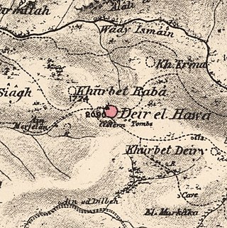
Dayr al-Hawa was a Palestinian Arab village in the Jerusalem Subdistrict. The village was depopulated during the 1948 Arab-Israeli War on October 19, 1948, by the Fourth Battalion of the Har'el Brigade of Operation ha-Har. It was located 18.5 km west of Jerusalem.

Al-Maghar was a Palestinian Arab village in the Ramle Subdistrict of Mandatory Palestine. It was depopulated by the Givati Brigade during Operation Barak on 18 May 1948. It was located 12 km southwest of Ramla, situated north of Wadi al-Maghar.

Al-Mansura was a small Palestinian Arab village in the Ramle Subdistrict, located 10 km south of Ramla. It was depopulated during the 1947–48 Civil War in Mandatory Palestine on April 20, 1948, under Operation Barak.

Al-Mukhayzin was a Palestinian village in the Ramle Subdistrict. It was ethnically cleansed during the Nakba on April 20, 1948, by the Givati Brigade of Operation Har'el. It was located 10 km southwest of Ramla.

Al-Mansura was a Palestinian Arab village in the Tiberias Subdistrict. It was depopulated during the 1947–1948 Civil War in Mandatory Palestine on May 10, 1948. It was located 16 kilometres northwest of Tiberias.

Zikrin, pronounced Dhikrin, was a Palestinian Arab village in the Hebron Subdistrict, depopulated in the 1948 Palestine War. The site is located about 6 kilometres (3.7 mi) northwest of Beit Gubrin and sits at a mean elevation of 212 metres (696 ft) above sea-level, its access somewhat impeded by hedges of buckthorn and cactus. The entire site is dotted with grottoes and caves, and razed structures.
 1870s map
  1940s map
 modern map
  1940s with modern overlay map


