Winnetka is a neighborhood in the west-central San Fernando Valley in the city of Los Angeles. It is a highly ethnically diverse area, both for the city and for Los Angeles County, with a relatively large percentage of Hispanic and Asian people.

Sun Valley is a neighborhood in Los Angeles, California in the San Fernando Valley region. The neighborhood is known for its overall youthful population and moderate racial diversity. There are three recreation centers in Sun Valley, one of which is a historic site. The neighborhood has thirteen public schools — including John H. Francis Polytechnic High School and Sun Valley High School — and four private schools.

The Santa Clarita Valley is part of the upper watershed of the Santa Clara River in Southern California. The valley was part of the 48,612-acre (19,673 ha) Rancho San Francisco Mexican land grant. Located in Los Angeles County, its main population center is the city of Santa Clarita which includes the communities of Canyon Country, Newhall, Saugus, and Valencia. Adjacent unincorporated communities include Castaic, Stevenson Ranch, Val Verde, and the new master planned community of Newhall Ranch.

The Victor Valley is a valley in the Mojave Desert and subregion of the Inland Empire, in San Bernardino County in Southern California.
Ruben F. Salazar Park is a park in East Los Angeles, Los Angeles County, California.

Beverly Drive is a major north-south roadway in Beverly Hills and Los Angeles.

Hidden Valley is a valley in the Santa Monica Mountains, in southeastern Ventura County, Southern California. The Unincorporated community in the valley is a equestrian ranch community with single family houses on 20-acre or more (8.1 ha) parcels of land. Residents rely on wells as the Hidden Valley Municipal Water District does not provide drinking water.

Eaton Canyon is a major canyon beginning at the Eaton Saddle near Mount Markham and San Gabriel Peak in the San Gabriel Mountains in the Angeles National Forest, United States. Its drainage flows into the Rio Hondo river and then into the Los Angeles River. It is named after Judge Benjamin S. Eaton, who lived in the Fair Oaks Ranch House in 1865 not far from Eaton Creek.

The Providence Mountains State Recreation Area is located in the Providence Mountains, within the Mojave National Preserve in San Bernardino County, California. It is also home to the Mitchell Caverns Natural Preserve.
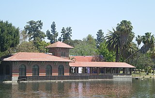
Lincoln Park in Los Angeles, California, was originally created by the City of Los Angeles in 1881 from land donated by John Strother Griffin. It was one of Los Angeles's first parks. It was originally called East Los Angeles Park, then Eastlake Park in 1901. On May 19, 1917, the park was renamed Lincoln Park after Lincoln High School.

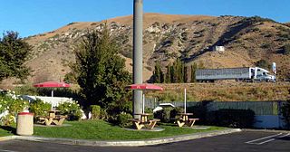
Santa Susana Pass State Historic Park is a California State Park of approximately 680 acres (2.8 km2) located on the boundary between Ventura and Los Angeles counties, between the communities of Chatsworth and Simi Valley. Geologically, the park is located where the Simi Hills meet the Santa Susana Mountains. Here in the western part of the Transverse Ranges, the land is dominated by high, narrow ridges and deep canyons covered with an abundant variety of plant life. The park offers panoramic views of the rugged natural landscape as a striking contrast to the developed communities nearby. The park is also rich in archaeological, historical, and cultural significance.

Marvin Braude Mulholland Gateway Park is a 1,500-acre (6.1 km2) park in the Santa Monica Mountains, with its trailhead at the southern terminus of Reseda Boulevard in Tarzana, Los Angeles, California. The park was named for former Los Angeles City Councilman Marvin Braude, who for more than 30 years led the effort to preserve the Santa Monica Mountains. It is part of the Santa Monica Mountains National Recreation Area.

Our Lady of the Valley is a large Catholic church and school located in the Canoga Park section of Los Angeles, California. It is the oldest parish in the western San Fernando Valley, having been established in 1921. When the parish was established, the western Valley was sparsely populated, and most of the 620 parishioners were involved in agriculture with livestock or walnut and orange groves. At the time of its formation, the parish’s boundaries covered 400 square miles (1,000 km2) from the Pacific Ocean to the south, the Ventura County line to the west, White Oak Avenue to the east, and the Santa Susana Mountains to the north. In the years after World War II, the San Fernando Valley shifted from agriculture to residential communities, and the Catholic population also swelled. The 400 square miles (1,000 km2) served by Our Lady of the Valley were carved up among nine sister parishes. Though its territory has been reduced to four square miles, the parish has grown from 620 parishioners to over 4100 families.
Villa Parke is a neighborhood in Pasadena, California,bordered by Mountain Street to the north, Interstate 210 to the south, Fair Oaks Avenue to the west, and Los Robles Avenue to the east.
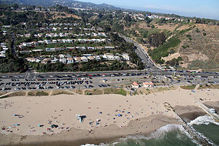
Will Rogers State Beach is a beach park on the Santa Monica Bay, at the Pacific coast of Southern California. Located in Pacific Palisades, the beach is owned by the California Department of Parks and Recreation; however, it is managed and maintained by the Los Angeles County Department of Beaches and Harbors. A section just south of the intersection of Pacific Coast Highway and Entrada Drive is popular within the LGBT community and is therefore considered Los Angeles' unofficial gay beach; this section is often referred to as Ginger Rogers Beach.
Ernest E. Debs Regional Park is a large open space nature reserve and regional park in the Montecito Heights neighborhood of central-northeast Los Angeles, California.
Rancho Los Alamos y Agua Caliente was a 26,626-acre (107.75 km2) Mexican land grant in present day Kern County, California given in 1846 by Governor Pio Pico to Francisco Lopes, Luis Jordan and Vicente Botiller. The name means "Cottonwoods and Hot Springs Ranch" in Spanish. The native riparian Fremont Cotonwood (Populus fremontii) grow around natural springs. Rancho Los Alamos y Agua Caliente lay between two other Mexican Land Grants in the Tehachapi Mountains, Rancho El Tejon and Rancho Castac. The rancho is now a part of the 270,000 acres (1,093 km2) Tejon Ranch.

Turlock Lake State Recreation Area is regional park and recreation area at Turlock Reservoir in Stanislaus County, central California.
Arroyo Calabasas is a 7.0-mile-long (11.3 km) tributary of the Los Angeles River, in the southwestern San Fernando Valley area of Los Angeles County in California.

Robert H. Meyer Memorial State Beach is a state beach of California, located in northern Malibu, Southern California.
The park is part of the Santa Monica Mountains National Recreation Area.