Khirbat al-'Umur

Last updated
Khirbat al-'Umur
خربة العمور
chirbet el-'amur
KhirbatAlUmurFeb182023 03.jpg
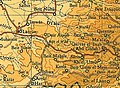
To the left are the remains of the village (in the forest clearing on the spur), above the riverbed. Up the riverbed is the village spring and the villages of Ein Rafa and Ein Nakuba.
Etymology: from Amorite [1]
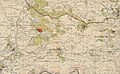
Historical map series for the area of Khirbat al-'Umur (1870s).jpg 1870s map
Historical map series for the area of Khirbat al-'Umur (1940s).jpg 1940s map
Historical map series for the area of Khirbat al-'Umur (modern).jpg modern map
Historical map series for the area of Khirbat al-'Umur (1940s with modern overlay).jpg 1940s with modern overlay map
A series of historical maps of the area around Khirbat al-'Umur (click the buttons)
Mandatory Palestine location map.svg
Red pog.svg
Khirbat al-'Umur
Location within Mandatory Palestine
Coordinates: 31°47′37″N35°05′56″E / 31.79361°N 35.09889°E / 31.79361; 35.09889 Coordinates: 31°47′37″N35°05′56″E / 31.79361°N 35.09889°E / 31.79361; 35.09889
Palestine grid 159/133
Geopolitical entity Mandatory Palestine
Subdistrict Jerusalem
Date of depopulationOctober 21, 1948 [2]
Area
  Total4,163  dunams (4.163 km2 or 1.607 sq mi)
Population
 (1945)
  Total270 [3] [4]
Cause(s) of depopulationMilitary assault by Yishuv forces
Current Localities Giv'at Ye'arim [5]

Khirbat al-'Umur was a Palestinian Arab village in the Jerusalem Subdistrict. It was depopulated during the 1948 Palestine war by the Har'el Brigade during Operation Ha-Har. It was 12 km west of Jerusalem on the Wadi al-Ghadir.

Contents

History

An Ottoman village list from about 1870 showed that chirbet el-'amur had a population of 69, with a total of 13 houses, though the population count included men, only. It also noted that it was located in the District of Beni Malik, south of Abu Ghosh, and east of Saris. [6] [7]

In 1883, the PEF's Survey of Western Palestine (SWP) described El Ammur as "A small hamlet on the slope above a deep valley. There is a fine perennial spring below on the south ('Ain Mahtush). There are olives beneath the village." [8]

British Mandate era

In the 1922 census of Palestine conducted by the British Mandate authorities, Kherbet al-'Amur had a population of 137 Muslims, [9] increasing in the 1931 census to 187 Muslims, in 45 houses. [10]

In the 1945 statistics, the village had a population of 270 Muslims, [3] while the total land area was 4,163 dunams, according to an official land and population survey. [4] Of this, 497 dunams were used for plantations and irrigable land, 1,279 for cereals, [11] while 10 dunams were classified as built-up areas. [12]

1948, aftermath

Khirbat al-'Umur became depopulated on October 21, 1948, after military assault by Yishuv forces. [2]

In 1950, Giv'at Ye'arim was founded on village land. [5]

In 1992, the village site was described: "Stone rubble and window and door frames, partly hidden by wild grass, are scattered across the village site. Many stone terraces are visible. Cactuses grow on the east and north sides of the village site, and almond, olive, fig, and cypress trees grow on the village site itself. The village cemetery, to the south, is covered with dirt and grass but many graves are visible; tombstones stand at the head and foot of each one. The spring of 'Ayn al-'Umur and the stone structure around it can still be seen." [5]

Related Research Articles

<span class="mw-page-title-main">Kawkaba</span> Place in Gaza, Mandatory Palestine

Kawkaba, known to the Crusaders as Coquebel, was a Palestinian Arab village that was occupied by Israel during Operation Yoav during the 1948 Arab-Israeli War, and depopulated.

<span class="mw-page-title-main">Bayt Naqquba</span> Place in Jerusalem, Mandatory Palestine

Bayt Naqquba was a Palestinian village in British Mandate Palestine, located 9.5 kilometers west of Jerusalem, near Abu Ghosh. Before Palmach and Haganah troops occupied the village during Operation Nachshon on April 11, 1948, approximately 300 Palestinian Arabs lived there. After the 1948 Arab–Israeli War, a moshav named Beit Nekofa was founded close to the site by Jewish immigrants from Yugoslavia. In 1962, residents of Bayt Naqubba built a new village named Ein Naqquba, south of Beit Nekofa.

<span class="mw-page-title-main">Bayt Jirja</span> Place in Gaza, Mandatory Palestine

Bayt Jirja was a Palestinian Arab village 15.5 km Northeast of Gaza. In 1931 the village consisted of 115 houses. It was overrun by Israeli forces during operation Yo'av in the 1948 Arab-Israeli war. Bayt Jirja was found depopulated in November 1948, during "clean up sweeps" to expel any partial inhabited villages and destroy village housing to prevent any possible re-occupation in the area. The village was completely destroyed after the occupation and only one tomb remains.

<span class="mw-page-title-main">Kudna</span> Place in Hebron, Mandatory Palestine

Kudna was a Palestinian Arab village, located 25 kilometers northwest of Hebron.

<span class="mw-page-title-main">Artuf</span> Place in Jerusalem, Mandatory Palestine

Artuf was a Palestinian village in the Jerusalem foothills depopulated in 1948. It was situated 21.5 kilometers (13.4 mi) west of Jerusalem on a high plateau, surrounded by plains on the south, east, and west. The village was on a secondary road that linked it to the main road to Jerusalem.

<span class="mw-page-title-main">Shahma</span> Village in Ramle, Mandatory Palestine

Shahma was a Palestinian Arab village located 15 kilometers (9.3 mi) southwest of Ramla. Depopulated on the eve of the 1948 Arab-Israeli war, the village lands today form part of a fenced-in area used by the Israeli Air Force.

<span class="mw-page-title-main">Hulayqat</span> Village in Gaza, Mandatory Palestine

Hulayqat was a Palestinian Arab village in the Gaza Subdistrict. It was depopulated during the 1947–1948 Civil War in Mandatory Palestine. It was located 20.5 km northeast of Gaza.

<span class="mw-page-title-main">Al-Khisas, Gaza</span> Village in Gaza, Mandatory Palestine

Al-Khisas was a Palestinian Arab village located 18.5 kilometers (11.5 mi) northeast of Gaza near the modern city of Ashkelon.

<span class="mw-page-title-main">Barqusya</span> Place in Hebron, Mandatory Palestine

Barqusya was a Palestinian Arab village in the Hebron Subdistrict, depopulated in the 1948 Palestine War. It was located 31 km northwest of Hebron.

<span class="mw-page-title-main">Mughallis</span> Village in Hebron, Mandatory Palestine

Mughallis was a Palestinian Arab village located 30.5 kilometers (19.0 mi) northwest of Hebron. It was depopulated during the 1948 Arab-Israeli War between July 9–10, 1948 as part of Operation An-Far.

<span class="mw-page-title-main">Khirbat Umm Burj</span> Place in Hebron, Mandatory Palestine

Khirbat Umm Burj was a Palestinian Arab village in the Hebron Subdistrict, sometimes designated in modern maps as Burgin. Its ruins are today located within the borders of Israel. It occupied an extensive site, stretching about 30 dunams on the crest of a hill, rising some 430 metres (1,410 ft) above sea level, and commanding a good prospect of the surrounding region. It was depopulated during the 1948 Arab–Israeli War on October 28, 1948, during the third stage of Operation Yo'av under the command of Yigal Allon. The site is located 17 km northwest of Hebron.

<span class="mw-page-title-main">Al-Safiriyya</span> Place in Jaffa, Mandatory Palestine

Al-Safiriyya was a Palestinian Arab village in the Jaffa Subdistrict. It was depopulated during Operation Hametz in the 1948 Palestine War on May 20, 1948. It was located 11 km east of Jaffa, 1.5 km west of Ben Gurion Airport.

<span class="mw-page-title-main">Dayr al-Hawa</span> Place in Jerusalem, Mandatory Palestine

Dayr al-Hawa was a Palestinian Arab village in the Jerusalem Subdistrict. The village was depopulated during the 1948 Arab-Israeli War on October 19, 1948, by the Fourth Battalion of the Har'el Brigade of Operation ha-Har. It was located 18.5 km west of Jerusalem.

<span class="mw-page-title-main">Al-Jura, Jerusalem</span> Place in Jerusalem, Mandatory Palestine

Al-Jura was a Palestinian Arab village in the Jerusalem Subdistrict. It was depopulated during the 1948 Arab-Israeli War on July 11, 1948, under Operation Danny. It was located 8.5 km west of Jerusalem. al-Jura was mostly destroyed with the exception of several deserted houses.

<span class="mw-page-title-main">Khirbat Al-Lawz</span> Place in Jerusalem, Mandatory Palestine

Khirbat Al-Lawz was a Palestinian Arab village in the Jerusalem Subdistrict. It was depopulated during the 1948 Arab-Israeli War on July 13, 1948, by the Har'el Brigade of Operation Dani. It was located 11 km west of Jerusalem, situated north of Wadi al-Sarar.

<span class="mw-page-title-main">Sufla</span> Place in Jerusalem, Mandatory Palestine

Sufla was a Palestinian Arab village in the Jerusalem Subdistrict. It was depopulated during the 1948 Arab–Israeli War on October 19, 1948, by the Sixth Battalion of the Harel Brigade under Operation Ha-Har. It was located 18.5 km west of Jerusalem.

<span class="mw-page-title-main">Al-Barriyya</span> Place in Ramle, Mandatory Palestine

Al-Barriyya was a Palestinian village in the Ramle Subdistrict of Mandatory Palestine. It was depopulated during the 1948 Arab–Israeli War on July 10, 1948, as part of Operation Dani. It was located 5.5 km southeast of Ramla, on the eastern bank of Wadi al-Barriyya.

<span class="mw-page-title-main">Dayr Muhaysin</span> Place in Ramle, Mandatory Palestine

Dayr Muhaysin was a Palestinian village in the Ramle Subdistrict of Mandatory Palestine, located 12 km southeast of Ramla and 4 km west of Latrun. It was depopulated during the 1948 Palestine war.

<span class="mw-page-title-main">Al-Na'ani</span> Place in Ramle, Mandatory Palestine

Al-Na'ani, also called Al-Ni'ana, was a Palestinian Arab village in the Ramle Subdistrict of Mandatory Palestine. It was depopulated during the 1948 Arab–Israeli War on May 14, 1948, by the Givati Brigade during Operation Barak. It was located 6 km south of Ramle.

<span class="mw-page-title-main">Al-Tira, Ramle</span> Place in Ramle, Mandatory Palestine

Al-Tira was a Palestinian village in the Ramle Subdistrict. It was depopulated during the 1948 Arab–Israeli War on July 10, 1948, by the Alexandroni and Armored (Eighth) brigades under Operation Dani. It was located 12 km northeast of Ramla. al-Tira was mostly destroyed with the exception of a few houses survived destruction.

References

  1. Palmer, 1881, pp. 283, 268
  2. 1 2 Morris, 2004, p. xx, village #350. Also gives cause of depopulation, with a "(?)"
  3. 1 2 Department of Statistics, 1945, p. 25
  4. 1 2 Government of Palestine, Department of Statistics. Village Statistics, April, 1945. Quoted in Hadawi, 1970, p. 57
  5. 1 2 3 Khalidi, 1992, p. 321
  6. Socin, 1879, p. 150
  7. Hartmann, 1883, p. 118 also noted 13 houses
  8. Conder and Kitchener, 1883, SWP III, p. 16
  9. Barron, 1923, Table VII, Sub-district of Jerusalem, p. 14
  10. Mills, 1932, p. 44
  11. Government of Palestine, Department of Statistics. Village Statistics, April, 1945. Quoted in Hadawi, 1970, p. 103
  12. Government of Palestine, Department of Statistics. Village Statistics, April, 1945. Quoted in Hadawi, 1970, p. 153

Bibliography