Related Research Articles

The Chickasaw are an Indigenous people of the Southeastern Woodlands, United States. Their traditional territory was in northern Mississippi, northwestern and northern Alabama, western Tennessee and southwestern Kentucky. Their language is classified as a member of the Muskogean language family. In the present day, they are organized as the federally recognized Chickasaw Nation.
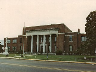
Neshoba County is located in the central part of the U.S. state of Mississippi. As of the 2020 census, the population was 29,087. Its county seat is Philadelphia.

Bogue Chitto is a census-designated place (CDP) situated in Kemper and Neshoba counties, Mississippi. The population was 864 at the 2020 census. It is part of the Mississippi Band of Choctaw Indians Reservation and the population is 93% Choctaw.

The Tombigbee River is a tributary of the Mobile River, approximately 200 mi (325 km) long, in the U.S. states of Mississippi and Alabama. Together with the Alabama, it merges to form the short Mobile River before the latter empties into Mobile Bay on the Gulf of Mexico. The Tombigbee watershed encompasses much of the rural coastal plain of western Alabama and northeastern Mississippi, flowing generally southward. The river provides one of the principal routes of commercial navigation in the southern United States, as it is navigable along much of its length through locks and connected in its upper reaches to the Tennessee River via the Tennessee-Tombigbee Waterway.
The Yazoo were a tribe of the Native American Tunica people historically located along the lower course of the Yazoo River in an area now known as the Mississippi Delta. They were closely related to other Tunica language–speaking peoples, especially the Tunica, Koroa, and possibly the Tioux.
The Mississippi Band of Choctaw Indians is one of three federally recognized tribes of Choctaw people, and the only one in the state of Mississippi. On April 20, 1945, this tribe organized under the Indian Reorganization Act of 1934. Their reservation included lands in Neshoba, Leake, Newton, Scott, Jones, Attala, Kemper, and Winston counties. The Mississippi Choctaw regained stewardship of their mother mound, Nanih Waiya mounds and cave in 2008. The Mississippi Band of Choctaw have declared August 18 as a tribal holiday to celebrate their regaining control of the sacred site. The other two Choctaw groups are the Choctaw Nation of Oklahoma, the third largest tribe in the United States, and the Jena Band of Choctaw Indians, located in Louisiana.
Bogue Chitto is an unincorporated community and census-designated place (CDP) in Lincoln County, Mississippi, United States. As of the 2020 census, it had a population of 437. Bogue Chitto is the only municipal hamlet in the state of Mississippi.
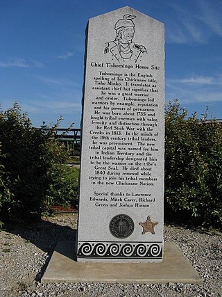
Tishomingo ; was a renowned war chief of the Chickasaw nation in Mississippi.
Bogue Chitto State Park is a Louisiana state park located off Louisiana State Highway 25 south of Franklinton, in Washington Parish. The name Bogue Chitto is from the Choctaw language, bok chito, meaning big creek. Bogue Chitto is a relatively recent addition to the Louisiana State Park system. It opened to the public on August 28, 2010, after a delay of approximately three months.
The 5th Mississippi Infantry Regiment was a regiment of infantry in the Confederate States Army during the American Civil War. The 5th Regiment was composed of volunteer companies from central Mississippi and assembled in the fall of 1861 by Colonel Albert E. Fant. After taking heavy casualties in battles in Georgia and Tennessee, the regiment surrendered in April 1865.

The 1972 United States presidential election in Mississippi was held on November 7, 1972. Incumbent President Nixon won the state of Mississippi with 78.20% of the vote. This was the highest percentage Nixon received in any state in the election.
The Bogue Chitto River is a stream in the U.S. states of Louisiana and Mississippi. It is a tributary of the Pearl River.

Chickasawhay Creek is a stream in the U.S. state of Mississippi. It is a tributary to Okatibbee Creek.

Potterchitto Creek is a stream in the U.S. state of Mississippi. It is a tributary to the Chunky River. Tributaries include Tarlow Creek and Bogue Falema Creek.
Tallabogue Creek is a stream in the U.S. state of Mississippi. It is a tributary to the Chickasawhay River.
Topisaw Creek is a stream in the U.S. state of Mississippi. It is a tributary to Bogue Chitto.
References
Citations
- ↑ "Freelang Ojibwe Dictionary". Archived from the original on 2012-10-11. Retrieved 2011-04-08.
- ↑ "Michigan in Brief: Information About the State of Michigan" (PDF). Michigan.gov. Archived (PDF) from the original on 2006-11-08. Retrieved 2006-11-28.
- ↑ "Mississippi". American Heritage Dictionary . Yourdictionary.com. Archived from the original on February 20, 2007. Retrieved 2007-03-06.
- 1 2 3 4 Baca (2007), p. 4.
- ↑ Baca (2007), p. 25.
- 1 2 3 4 Baca (2007), p. 29.
- ↑ Baca (2007), p. 44.
- 1 2 3 4 Baca (2007), p. 10.
- 1 2 3 4 Baca (2007), p. 62.
- 1 2 3 Baca (2007), p. 84.
- 1 2 3 4 5 Baca (2007), p. 130.
- 1 2 3 4 5 Baca (2007), p. 3.
- 1 2 3 4 Baca (2007), p. 5.
- 1 2 3 4 Baca (2007), p. 8.
- ↑ "Bogue Chitto Creek". Geographic Names Information System . United States Geological Survey, United States Department of the Interior.
- ↑ "Bogue Chitto". Geographic Names Information System . United States Geological Survey, United States Department of the Interior.
- ↑ "Bogue Chitto". Geographic Names Information System . United States Geological Survey, United States Department of the Interior.
- ↑ "Bogue Chitto". Geographic Names Information System . United States Geological Survey, United States Department of the Interior.
- 1 2 3 4 5 6 7 Baca (2007), p. 15.
- 1 2 3 4 Baca (2007), p. 16.
- 1 2 3 4 Baca (2007), p. 17.
- 1 2 3 Baca (2007), p. 18.
- 1 2 3 Baca (2007), p. 20.
- 1 2 3 4 Baca (2007), p. 21.
- 1 2 3 4 Baca (2007), p. 24.
- 1 2 3 4 Baca (2007), p. 27.
- 1 2 3 4 5 6 Baca (2007), p. 30.
- 1 2 3 4 Baca (2007), p. 32.
- 1 2 3 4 5 Baca (2007), p. 33.
- 1 2 3 Baca (2007), p. 34.
- 1 2 3 Baca (2007), p. 35.
- 1 2 3 Baca (2007), p. 38.
- 1 2 3 Baca (2007), p. 40.
- 1 2 3 4 5 6 7 8 Baca (2007), p. 41.
- ↑ Baca (2007), p. 43.
- 1 2 3 Baca (2007), p. 45.
- ↑ Baca (2007), p. 46.
- 1 2 3 4 5 Baca (2007), p. 48.
- 1 2 Baca (2007), p. 49.
- 1 2 3 4 5 Baca (2007), p. 51.
- 1 2 3 Baca (2007), p. 52.
- 1 2 3 4 Baca (2007), p. 54.
- 1 2 3 Baca (2007), p. 55.
- 1 2 3 Baca (2007), p. 59.
- ↑ Baca (2007), p. 59-60.
- ↑ Baca (2007), p. 42.
- 1 2 3 4 Baca (2007), p. 64.
- 1 2 3 Baca (2007), p. 65.
- 1 2 3 4 Baca (2007), p. 70.
- 1 2 3 4 Baca (2007), p. 71.
- 1 2 Baca (2007), p. 74.
- 1 2 3 Baca (2007), p. 76.
- 1 2 3 4 Baca (2007), p. 77.
- 1 2 3 4 5 Baca (2007), p. 78.
- 1 2 3 4 Baca (2007), p. 81.
- 1 2 3 4 Baca (2007), p. 86.
- 1 2 3 4 Baca (2007), p. 89.
- 1 2 3 4 Baca (2007), p. 90.
- 1 2 3 4 5 6 Baca (2007), p. 91.
- 1 2 3 4 5 6 7 Baca (2007), p. 93.
- 1 2 3 Baca (2007), p. 94.
- 1 2 3 4 Baca (2007), p. 96.
- 1 2 3 4 5 6 Baca (2007), p. 97.
- 1 2 3 4 Baca (2007), p. 98.
- 1 2 3 4 Baca (2007), p. 99.
- 1 2 3 4 5 6 Baca (2007), p. 101.
- 1 2 3 Baca (2007), p. 105.
- 1 2 3 4 5 Baca (2007), p. 108.
- 1 2 3 4 Baca (2007), p. 109.
- 1 2 3 4 Baca (2007), p. 110.
- 1 2 Baca (2007), p. 112.
- 1 2 Baca (2007), p. 113.
- 1 2 3 Baca (2007), p. 114.
- 1 2 3 Baca (2007), p. 117.
- 1 2 3 Baca (2007), p. 119.
- 1 2 3 Baca (2007), p. 120.
- 1 2 3 4 Baca (2007), p. 121.
- 1 2 Baca (2007), p. 122.
- 1 2 3 Baca (2007), p. 123.
- 1 2 3 4 Baca (2007), p. 124.
- 1 2 3 4 Baca (2007), p. 125.
- 1 2 3 4 Baca (2007), p. 128.
- 1 2 3 Baca (2007), p. 129.
- 1 2 3 Baca (2007), p. 135.
- 1 2 3 Baca (2007), p. 6.
- 1 2 3 4 5 6 Baca (2007), p. 7.
- 1 2 Baca (2007), p. 100.
- 1 2 3 4 Baca (2007), p. 9.
- 1 2 3 Baca (2007), p. 11.
- ↑ "Boque Falia Creek". Geographic Names Information System . United States Geological Survey, United States Department of the Interior.
- 1 2 Baca (2007), p. 12.
- 1 2 Baca (2007), p. 13.
- 1 2 3 Baca (2007), p. 14.
- 1 2 3 4 Baca (2007), p. 19.
- 1 2 3 Baca (2007), p. 22.
- 1 2 3 4 Baca (2007), p. 23.
- ↑ "Chittobochiah Creek". Geographic Names Information System . United States Geological Survey, United States Department of the Interior.
- ↑ Baca (2007), p. 26.
- 1 2 Baca (2007), p. 28.
- 1 2 Baca (2007), p. 31.
- 1 2 Baca (2007), p. 36.
- 1 2 3 4 Baca (2007), p. 37.
- 1 2 3 Baca (2007), p. 39.
- 1 2 3 Baca (2007), p. 47.
- 1 2 3 Baca (2007), p. 50.
- 1 2 3 Baca (2007), p. 58.
- 1 2 3 4 5 Baca (2007), p. 82.
- 1 2 3 4 Baca (2007), p. 87.
- 1 2 3 Baca (2007), p. 92.
- 1 2 3 Baca (2007), p. 106.
- ↑ Baca (2007), p. 53.
- ↑ Baca (2007), p. 60.
- ↑ Baca (2007), p. 66.
- 1 2 Baca (2007), p. 68.
- 1 2 Baca (2007), p. 69.
- 1 2 Baca (2007), p. 72.
- 1 2 3 Baca (2007), p. 73.
- 1 2 Baca (2007), p. 75.
- 1 2 3 Baca (2007), p. 80.
- 1 2 3 Baca (2007), p. 85.
- 1 2 Baca (2007), p. 88.
- ↑ "Snoody Creek". Geographic Names Information System . United States Geological Survey, United States Department of the Interior.
- ↑ Baca (2007), p. 95.
- 1 2 Baca (2007), p. 102.
- 1 2 3 Baca (2007), p. 103.
- ↑ Baca (2007), p. 104.
- 1 2 Baca (2007), p. 107.
- 1 2 3 4 Baca (2007), p. 111.
- 1 2 3 Baca (2007), p. 115.
- ↑ Baca (2007), p. 127.
- 1 2 3 Baca (2007), p. 131.
- ↑ Baca (2007), p. 132.
- ↑ Baca (2007), p. 133.
- ↑ Baca (2007), p. 134.
- ↑ Baca (2007), p. 136.
Sources
- Baca, Keith (2007). Native American Place Names in Mississippi. Jackson, Mississippi: University Press of Mississippi.
- Bright, William (2004). Native American Placenames of the United States. Norman: University of Oklahoma Press. ISBN 080613576X.