The Citadelle of Quebec,also known as La Citadelle,is an active military installation and the secondary official residence of both the Canadian monarch and the governor general of Canada. It is located atop Cap Diamant,adjoining the Plains of Abraham in Quebec City,Quebec. The citadel contains the oldest military building in Canada,and forms part of the fortifications of Quebec City,which is one of only two cities in North America still surrounded by fortifications,the other being Campeche,Mexico.

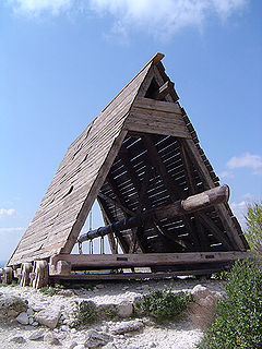
A siege engine is a device that is designed to break or circumvent heavy castle doors,thick city walls and other fortifications in siege warfare. Some are immobile,constructed in place to attack enemy fortifications from a distance,while others have wheels to enable advancing up to the enemy fortification. There are many distinct types,such as siege towers that allow foot soldiers to scale walls and attack the defenders,battering rams that damage walls or gates,and large ranged weapons that attack from a distance by launching projectiles. Some complex siege engines were combinations of these types.

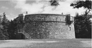
Martello towers,sometimes known simply as Martellos,are small defensive forts that were built across the British Empire during the 19th century,from the time of the French Revolutionary Wars onwards. Most were coastal forts.

Fort Henry National Historic Site is located in Kingston,Ontario,Canada on Point Henry,a strategic,elevated point near the mouth of the Cataraqui River where it flows into the St. Lawrence River at the east end of Lake Ontario. The fort and the point on which the fort was built were named after Henry Hamilton,former Lieutenant-Governor of the Province of Quebec.

Shoreham Redoubt is a historical military defensive structure and scheduled monument at the entrance to Shoreham harbour,at the mouth of the River Adur in West Sussex,England. It was planned in the 1850s during a period of political alarm in the United Kingdom. Construction of the fort was completed in June 1857 at a cost of £11,685. The design is similar to that of Littlehampton Fort,which had been built in 1854.

The Western Heights of Dover are one of the most impressive fortifications in Britain. They comprise a series of forts,strong points and ditches,designed to protect the country from invasion. They were created in the 18th and 19th centuries to augment the existing defences and protect the key port of Dover from both seaward and landward attack;by the start of the 20th century Dover Western Heights was collectively reputed to be the 'strongest and most elaborate' fortification in the country. The Army finally withdrew from the Heights in 1956–61;they are now a local nature reserve.

Eastbourne Redoubt is a circular coastal defence fort at Eastbourne,East Sussex,on the south coast of England. It was built in 1805 as part of the British anti-invasion preparations during the Napoleonic Wars. The building is now owned by the local authority and is open to the public.

Shornemead Fort is a now-disused artillery fort that was built in the 1860s to guard the entrance to the Thames from seaborne attack. Constructed during a period of tension with France,it stands on the south bank of the river at a point where the Thames curves sharply north and west,giving the fort long views up and downriver in both directions. It was the third fort constructed on the site since the 18th century,but its location on marshy ground led to major problems with subsidence. The fort was equipped for a time with a variety of large-calibre artillery guns which were intended to support two other nearby Thamesside forts. However,the extent of the subsidence meant that it became unsafe for the guns to be fired and the fort was disarmed by the early 20th century.

Crownhill Fort is a Royal Commission Fort built in the 1860s in Crownhill as part of Lord Palmerston's ring of land defences for Plymouth. Restored by the Landmark Trust,it is now home to several small businesses,museums,exhibitions and a holiday apartment sleeping up to eight people. The Fort is open to the public on the last Friday of each month and hosts tours for local schools and societies at other times.

Fort Pitt is a Napoleonic era fort on the high ground of the boundary between Chatham and Rochester,Kent.

A caponier is a type of defensive structure in a fortification. Fire from this point could cover the ditch beyond the curtain wall to deter any attempt to storm the wall. The word originates from the French caponnière,meaning "chicken coop".

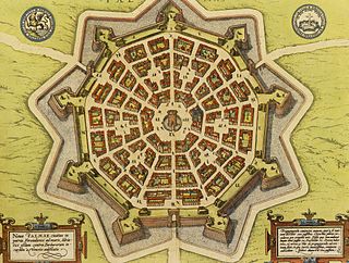
A bastion fort or trace italienne is a fortification in a style that evolved during the early modern period of gunpowder when the cannon came to dominate the battlefield. It was first seen in the mid-fifteenth century in Italy. Some types,especially when combined with ravelins and other outworks,resembled the related star fort of the same era.

The Battlefields Park includes the Plains of Abraham with the nearby and smaller Des Braves park,both within the district of Montcalm in Quebec City,and forms one of the few Canadian national urban parks. Its significance lies in the Battle of the Plains of Abraham (1759) and the Battle of Sainte-Foy,fought six months later on today's Des Braves park.

Fort Wellington National Historic Site is a historic military fortification located on the north shore of the St. Lawrence River at Prescott,Ontario. The military fortification was used by the British Army,and the Canadian militia for most of the 19th century,and by the militia in the 20th century,until 1923,when the property was handed over to the Dominion Parks Commission,the predecessor to Parks Canada. The fort was earlier named a National Historic Site of Canada in January 1920.

Fort Frederick is a historic military building located on Point Frederick on the grounds of the Royal Military College of Canada (RMC) in Kingston,Ontario,Canada. Its construction dates to 1846 and the Oregon boundary dispute. The fort consists of earthworks surrounding a Martello tower. Fort Frederick is included in two separate National Historic Sites of Canada:Kingston Fortifications National Historic Site and the Point Frederick Buildings National Historic Site.

Cathcart Tower is a Martello tower located on Cedar Island in the St. Lawrence River,off the eastern shore of Fort Henry in Kingston,Ontario,Canada. It is one of four such towers built in the 1840s to protect Kingston's harbour and the entrance to the Rideau Canal. The other towers are:Fort Frederick,Shoal Tower,and Murney Tower. Alexander Mackenzie was a foreman on the construction of the Carthcart Tower and later went on to become Canada's second prime minister 1873–1878. It was his work crew whose boat capsized while returning from Cedar Island,drowning 17 men. Hamilton Cove was subsequently renamed Deadman's Bay.

Freshwater Redoubt,also known as Fort Redoubt is an old Palmerston fort built in Freshwater Bay on the western end of the Isle of Wight. Construction work for the fort began in 1855 and was completed in 1856. It was finally sold in 1928 and has now been converted into a private residence.

Shoal Tower,originally known as Victoria Tower,is a Martello tower located in the harbour of Kingston,Ontario,Canada,directly opposite Kingston City Hall. It is one of four such towers built in the 1840s to protect Kingston's harbour and the entrance to the Rideau Canal. Cathcart Tower on Cedar Island,Shoal Tower in the Confederation Basin,Fort Frederick on the grounds of the Royal Military College of Canada,and Murney Tower were part of the same strategic improvements. Although 16 Martello towers were built in Canada,only 11 are still standing,four of them in Kingston.


