History
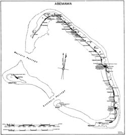
After the taking of Abemama US Navy Seabees The 95th Seabee Naval Construction Battalion landed on Abemama on November 28. The island was taken with minor fighting by the United States Marine Corps that landed on November 24, 1943. [2] The Seabee built a 4,000-foot (1,200 m) long by 150-foot (46 m) wide coral runway for fighter planes. The Apemama Airfield was named, O’Hare Field. The coral-paved runway was completed on December 10, with the first plane landing on December 13. The runway was extended to 6,000 feet (1,800 m) to support bombers by December 21. Later, it was extended to 7,700 feet (2,300 m) and widened to 200 feet (61 m) to support heavy bombers, like the B-29 Superfortress. A 1,950-foot (590 m) sand runway was built for smaller planes. The Seabee built a causeway dock and a coconut log pier so ships could unload supplies and was used for minor repair of Landing Ship, Tanks and small boats and ships. A 12,000-barrel aviation-gasoline tank farm was built. Seabee built with quonset huts: storage depot, a small hospital, a power station, refrigeration storage, offices, mess hall, Seabee camp and workshops. Tents city built for personnel stationed at the port and airfield. Abemama atoll is 15 miles (24 km) long and 6 miles (9.7 km) wide with a protected lagoon. The lagoon offered good fleet anchorage. Local native labor was employed in the initial phase of construction. A workforce of 426 was hired to unload at the beach and supply coconut logs for the pier. There were four bombing raids on the runway during the construction, one Consolidated B-24 Liberator was lost and there was minor damage to the airfield. A low-tide coral quarry was operated for the runway, roads and other uses. The Abemama location provided bombing missions to adjacent Japanese bases in the Gilberts and Marshall Islands. By 1944 the war has moved west to more forward bases. As such most operations at Apamama had moved off the island. Seabee Construction Battalion Maintenance Unit, CBMU 557 maintain the base, for the United States Army Air Forces, until its closure in the fall of 1944. The [3] [1]
Bases were built on two other Gilbert Islands: Naval Base Tarawa and Makin Island.
This page is based on this
Wikipedia article Text is available under the
CC BY-SA 4.0 license; additional terms may apply.
Images, videos and audio are available under their respective licenses.