
Ishwa' was a Palestinian village which was depopulated during the 1948 Arab-Israeli war. The village was located about 20 km west of Jerusalem, on the present location of Eshta'ol. In the 1931 British census of Palestine, Ishwa had a population of 468 in 126 houses. The village was occupied by the Israel Defense Forces (IDF) on July 16, 1948, in Operation Dani by the Harel Brigade. All of its inhabitants fled or were expelled.
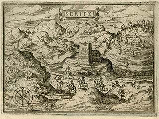
Saris was a Palestinian Arab village that was depopulated during the major offensive launched by the Haganah on 16 April 1948. Called Operation Nachshon, and launched before the British had left Palestine, its objective was to capture villages between Jerusalem and the coastal plain, in order to break to siege of the Jews of Jerusalem.
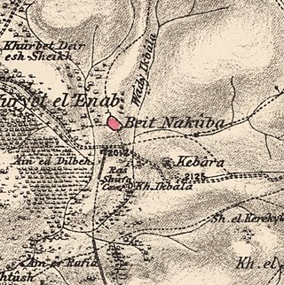
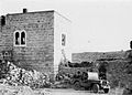
Bayt Naqquba was a Palestinian village in British Mandate Palestine, located 9.5 kilometers west of Jerusalem, near Abu Ghosh. Before Palmach and Haganah troops occupied the village during Operation Nachshon on April 11, 1948, approximately 300 Palestinian Arabs lived there. After the 1948 Arab–Israeli War, a moshav named Beit Nekofa was founded close to the site by Jewish immigrants from Yugoslavia. In 1962, residents of Bayt Naqubba built a new village named Ein Naqquba, south of Beit Nekofa.

Ra'na was a village located approximately 26 km northwest of Hebron. It was occupied by the Israeli army during Operation Yo'av in October 1948. It was one of 16 villages in the Hebron district that were depopulated.
Artuf was a Palestinian village in the Jerusalem foothills depopulated in 1948. It was situated 21.5 kilometers (13.4 mi) west of Jerusalem on a high plateau, surrounded by plains on the south, east, and west. The village was on a secondary road that linked it to the main road to Jerusalem.

Shahma was a Palestinian Arab village located 15 kilometers (9.3 mi) southwest of Ramla. Depopulated on the eve of the 1948 Arab-Israeli war, the village lands today form part of a fenced-in area used by the Israeli Air Force.

Barqusya was a Palestinian Arab village in the Hebron Subdistrict, depopulated in the 1948 Palestine War. It was located 31 km northwest of Hebron.
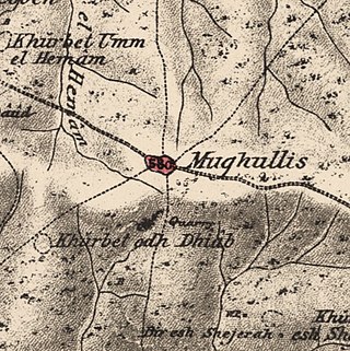
Mughallis was a Palestinian Arab village located 30.5 kilometers (19.0 mi) northwest of Hebron. It was depopulated during the 1948 Arab-Israeli War between July 9–10, 1948 as part of Operation An-Far.

Aqqur was a Palestinian Arab hamlet in the Jerusalem Subdistrict. Founded in the Ottoman period, it had a population of 25 in 1922 and 40 in 1945. It was depopulated during the 1948 Arab-Israeli War on July 13, 1948, under Operation Dani. It was located 14.5 km west of Jerusalem on the Wadi Isma'il, a tributary of the Wadi al-Sarar.
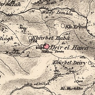
Dayr al-Hawa was a Palestinian Arab village in the Jerusalem Subdistrict. The village was depopulated during the 1948 Arab-Israeli War on October 19, 1948, by the Fourth Battalion of the Har'el Brigade of Operation ha-Har. It was located 18.5 km west of Jerusalem.
Khirbat Al-Lawz was a Palestinian Arab village in the Jerusalem Subdistrict. It was depopulated during the 1948 Arab-Israeli War on July 13, 1948, by the Har'el Brigade of Operation Dani. It was located 11 km west of Jerusalem, situated north of Wadi al-Sarar.

Sufla was a Palestinian Arab village in the Jerusalem Subdistrict. It was depopulated during the 1948 Arab–Israeli War on October 19, 1948, by the Sixth Battalion of the Harel Brigade under Operation Ha-Har. It was located 18.5 km west of Jerusalem.

Khirbat al-'Umur was a Palestinian Arab village in the Jerusalem Subdistrict. It was depopulated during the 1948 Palestine war by the Har'el Brigade during Operation Ha-Har. It was 12 km west of Jerusalem on the Wadi al-Ghadir.

Al-Barriyya was a Palestinian village in the Ramle Subdistrict of Mandatory Palestine. It was depopulated during the 1948 Arab–Israeli War on July 10, 1948, as part of Operation Dani. It was located 5.5 km southeast of Ramla, on the eastern bank of Wadi al-Barriyya.

Dayr Ayyub was a Palestinian Arab village in the Ramle Subdistrict. It was depopulated during the 1947–48 Civil War in Mandatory Palestine on March 6, 1948 by the Givati and Sheva' brigades of Operation Nachshon. It was located 17.5 km southeast of Ramla, situated close to Bab al-Wad. On attack, the village was defended by the Jordanian Army but was mostly destroyed with the exception of a few houses and the village cemetery.

Dayr Tarif was a Palestinian Arab village in the Ramle Subdistrict of Mandatory Palestine. It was depopulated during the 1948 Arab-Israeli War on July 10, 1948.

Al-Haditha was a Palestinian village in the Ramle Subdistrict. It was located 8 km northeast of Ramla, on the bank of Wadi al-Natuf. The site, now known as Tel Hadid, has yielded significant archaeological remains from many periods. Al-Haditha was depopulated during the 1948 Arab-Israeli War on July 12, 1948, under the first stage of Operation Dani.

Al-Qubab was a Palestinian Arab village in the Ramle Subdistrict. It was depopulated in July 1948 during the Operation Dani led by the Yiftach Brigade.
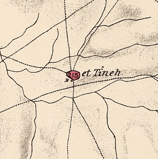
Al-Tina, or Khirbet et-Tineh was a Palestinian Arab village in the Ramle Subdistrict of Mandatory Palestine. The village was located between the Shfela and southern Israeli coastal plain. It was depopulated during the 1948 Arab–Israeli War on July 8, 1948, by the Givati Brigade under Operation An-Far. It was located 20. km south of Ramla. The hill on which the village was built stands today next to the Kiryat Mal'akhi – Yoav railway station and next to Highway 6. Archeological excavations at the site revealed the remains of a Byzantine settlement.

Al-Tira was a Palestinian village in the Ramle Subdistrict. It was depopulated during the 1948 Arab–Israeli War on July 10, 1948, by the Alexandroni and Armored (Eighth) brigades under Operation Dani. It was located 12 km northeast of Ramla. al-Tira was mostly destroyed with the exception of a few houses survived destruction.
 1870s map
  1940s map
 modern map
  1940s with modern overlay map


