Chattahoochee County | |
---|---|
Coordinates: 32°21′N84°47′W / 32.35°N 84.79°W | |
Country | United States |
State | Georgia |
Founded | 1854 |
Named for | Chattahoochee River |
Seat | Cusseta |
Largest city | Cusseta |
Area | |
• Total | 251 sq mi (650 km2) |
• Land | 249 sq mi (640 km2) |
• Water | 2.4 sq mi (6 km2) 1.0% |
Population (2020) | |
• Total | 9,565 |
• Density | 38/sq mi (15/km2) |
Time zone | UTC−5 (Eastern) |
• Summer (DST) | UTC−4 (EDT) |
Congressional district | 2nd |
Website | ugoccc.com |
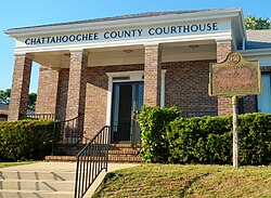
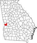
Chattahoochee County, also known as Cusseta-Chattahoochee County, [1] is a county located on the western border in central Georgia. As of the 2020 census, the population was 9,565. [2] The county seat is Cusseta, [3] with which the county shares a consolidated city-county government. The city of Cusseta remains a geographically distinct municipality within Chattahoochee County. [1] [4] The county was created on February 13, 1854.
Chattahoochee County is included in the Columbus, GA-AL metropolitan statistical area.
This area was occupied by the historic Muscogee people (also known as the Creek) at the time of European encounter. They had a large confederacy in the Southeast. They were among the Five Civilized Tribes who were forcibly removed to Indian Territory in the 1830s during the administration of President Andrew Jackson. European Americans moved into their former areas, in some cases acquiring land through lotteries run by the state.
The Georgia General Assembly created Chattahoochee County on February 13, 1854, from portions of Muscogee and Marion counties. It is named for the Chattahoochee River that forms its western boundary. [5] The county seat was named Cusseta to commemorate the historic Creek Indian town of that name that long existed nearby. In 2004–2005, the U.S. Census Bureau reported a 6.2% population decline, making this county at the top of those nationally with shrinking populations.
The original courthouse, built in 1854 by enslaved African Americans, is preserved at the tourist attraction of Westville in Columbus, Georgia.
Since 1918, most of the land in Chattahoochee County has been part of the Fort Moore military reservation. [6]
According to the U.S. Census Bureau, the county has a total area of 251 square miles (650 km2), of which 249 square miles (640 km2) is land and 2.4 square miles (6.2 km2) (1.0%) is water. [7]
The vast majority of Chattahoochee County is located in the Middle Chattahoochee River-Walter F. George Lake subbasin of the ACF River Basin (Apalachicola-Chattahoochee-Flint River Basin). The very small southeastern corner of the county is located in the Kinchafoonee-Muckalee subbasin of the same larger ACF Basin. [8] The county forms part of the West Georgia region.
Census | Pop. | Note | %± |
---|---|---|---|
1860 | 5,797 | — | |
1870 | 6,059 | 4.5% | |
1880 | 5,670 | −6.4% | |
1890 | 4,902 | −13.5% | |
1900 | 5,790 | 18.1% | |
1910 | 5,586 | −3.5% | |
1920 | 5,266 | −5.7% | |
1930 | 8,894 | 68.9% | |
1940 | 15,138 | 70.2% | |
1950 | 12,149 | −19.7% | |
1960 | 13,011 | 7.1% | |
1970 | 25,813 | 98.4% | |
1980 | 21,732 | −15.8% | |
1990 | 16,934 | −22.1% | |
2000 | 14,882 | −12.1% | |
2010 | 11,267 | −24.3% | |
2020 | 9,565 | −15.1% | |
2023 (est.) | 8,661 | [9] | −9.5% |
U.S. Decennial Census [10] 1790-1880 [11] 1890-1910 [12] 1920-1930 [13] 1930-1940 [14] 1940-1950 [15] 1960-1980 [16] 1980-2000 [17] 2010 [18] |
Race | Num. | Perc. |
---|---|---|
White | 5,403 | 56.49% |
Black or African American | 1,463 | 15.3% |
Native American | 35 | 0.37% |
Asian | 304 | 3.18% |
Pacific Islander | 104 | 1.09% |
Other/Mixed | 646 | 6.75% |
Hispanic or Latino | 1,610 | 16.83% |
As of the 2020 United States census, there were 9,565 people, 2,570 households, and 1,886 families residing in the county.
The Chattahoochee County School District holds pre-school to grade twelve, and consists of one elementary school, a middle school, and a high school. [20] The district has 85 full-time teachers and over 1000 students. [21]
All parts of the county except Fort Moore are zoned to county schools for all grades. Fort Moore children are zoned to Department of Defense Education Activity (DoDEA) schools for grades K-8. [22] However Fort Moore high school students attend the public high schools in the respective counties they are located in. [23]
Year | Republican | Democratic | Third party(ies) | |||
---|---|---|---|---|---|---|
No. | % | No. | % | No. | % | |
2020 | 880 | 55.63% | 667 | 42.16% | 35 | 2.21% |
2016 | 751 | 54.03% | 594 | 42.73% | 45 | 3.24% |
2012 | 735 | 49.23% | 729 | 48.83% | 29 | 1.94% |
2008 | 811 | 48.97% | 830 | 50.12% | 15 | 0.91% |
2004 | 905 | 53.55% | 773 | 45.74% | 12 | 0.71% |
2000 | 590 | 48.88% | 600 | 49.71% | 17 | 1.41% |
1996 | 398 | 36.78% | 565 | 52.22% | 119 | 11.00% |
1992 | 413 | 34.47% | 604 | 50.42% | 181 | 15.11% |
1988 | 454 | 55.57% | 362 | 44.31% | 1 | 0.12% |
1984 | 459 | 51.75% | 428 | 48.25% | 0 | 0.00% |
1980 | 256 | 34.04% | 476 | 63.30% | 20 | 2.66% |
1976 | 178 | 26.02% | 506 | 73.98% | 0 | 0.00% |
1972 | 345 | 74.03% | 121 | 25.97% | 0 | 0.00% |
1968 | 70 | 13.44% | 148 | 28.41% | 303 | 58.16% |
1964 | 246 | 56.29% | 191 | 43.71% | 0 | 0.00% |
1960 | 66 | 25.78% | 190 | 74.22% | 0 | 0.00% |
1956 | 43 | 28.67% | 107 | 71.33% | 0 | 0.00% |
1952 | 73 | 38.62% | 116 | 61.38% | 0 | 0.00% |
1948 | 1 | 0.86% | 46 | 39.66% | 69 | 59.48% |
1944 | 19 | 15.97% | 100 | 84.03% | 0 | 0.00% |
1940 | 20 | 8.93% | 204 | 91.07% | 0 | 0.00% |
1936 | 20 | 8.85% | 206 | 91.15% | 0 | 0.00% |
1932 | 1 | 0.53% | 186 | 99.47% | 0 | 0.00% |
1928 | 18 | 11.32% | 141 | 88.68% | 0 | 0.00% |
1924 | 14 | 6.17% | 208 | 91.63% | 5 | 2.20% |
1920 | 5 | 5.43% | 87 | 94.57% | 0 | 0.00% |
1916 | 4 | 2.42% | 156 | 94.55% | 5 | 3.03% |
1912 | 11 | 7.38% | 137 | 91.95% | 1 | 0.67% |
Webster County is a county located in the west central portion of the U.S. state of Georgia. As of the 2020 census reflected a population of 2,348, making it the third-least populous county in Georgia. The county seat is Preston.
Turner County is a county located in the south central portion of the U.S. state of Georgia. As of the 2020 census, the population was 9,006. The county seat is Ashburn. The county was created on August 18, 1905, and named for Henry G. Turner, U.S. representative and Georgia state Supreme Court justice.
Taylor County is a county located in the west central portion of the U.S. state of Georgia. As of the 2020 census, the population was 7,816. The county seat and largest city is Butler.
Talbot County is a county located in the west central portion of the U.S. state of Georgia. The 2020 census showed a population of 5,733. The county seat and largest city is Talbotton.
Stewart County is a county located in the west central portion of the U.S. state of Georgia. As of the 2020 census, the population was 5,314. The county seat is Lumpkin. The county was created on December 23, 1830.
Seminole County is a county located in the southwestern corner of U.S. state of Georgia. As of the 2020 census, the population was 9,147. The county seat is Donalsonville.
Muscogee County is a county located on the central western border of the U.S. state of Georgia named after the Muscogee that originally inhabited the land with its western border with the state of Alabama that is formed by the Chattahoochee River. As of the 2020 census, the population was 206,922. Its county seat and only city is Columbus, with which it has been a consolidated city-county since the beginning of 1971.
Marion County is a county located in the west central portion of the U.S. state of Georgia. As of the 2020 census, the county had a population of 7,498. The county seat is Buena Vista. The county was created on December 14, 1827. The county was named for General Francis Marion of South Carolina.
Lee County is a county located in the U.S. state of Georgia. As of the 2020 census, the population was 33,163. The county was established in 1825 and its county seat is Leesburg. Lee County is included in the Albany, GA metropolitan statistical area.
Harris County is a county located in the west-central portion of the U.S. state of Georgia; its western border with the state of Alabama is formed by the Chattahoochee River. As of the 2020 census, the population was 34,668. The county seat is Hamilton. The largest city in the county is Pine Mountain, a resort town that is home to the Franklin D. Roosevelt State Park. Harris County was created on December 14, 1827, and named for Charles Harris, a Georgia judge and attorney. Harris County is part of the Columbus, GA-AL metropolitan area and has become a popular suburban and exurban destination of residence for families relocating from Columbus. Because of this, Harris has become the sixth-wealthiest county in Georgia in terms of per capita income and the wealthiest in the state outside of Metro Atlanta.
Crisp County is a county located in the central portion of the U.S. state of Georgia. As of the 2020 census, the population was 20,128. The county seat is Cordele. The county was created on August 17, 1905, from Dooly County and named for Georgia Congressman Charles Frederick Crisp.
Coweta County is a county in the West Central region of the U.S. state of Georgia. It is part of Metro Atlanta. As of the 2020 census, the population was 146,158. The county seat is Newnan.
Carroll County is a county in the West Central region of the State of Georgia. As of the 2020 census, its population was 119,148. Its county seat is the city of Carrollton. Carroll County is included in the Atlanta–Sandy Springs–Roswell metropolitan statistical area and is also adjacent to Alabama on its western border.
Cusseta is a city in Chattahoochee County, Georgia, United States. It is part of the Columbus, Georgia-Alabama metropolitan statistical area. The population was 9,565 in 2020. The city is the county seat of Chattahoochee County, with which it shares a consolidated city-county government. Despite this, Cusseta is not coterminous with the county; it remains a geographically distinct municipality within the county.
Columbus is a consolidated city-county located on the west-central border of the U.S. state of Georgia. Columbus lies on the Chattahoochee River directly across from Phenix City, Alabama. It is the county seat of Muscogee County, with which it officially merged in 1970; the original merger excluded Bibb City, which joined in 2000 after dissolving its own city charter.
Fort Moore is a United States Army post in the Columbus, Georgia area. Located on Georgia's border with Alabama, Fort Moore supports more than 120,000 active-duty military, family members, reserve component soldiers, retirees and civilian employees on a daily basis. As a power projection platform, the post can deploy combat-ready forces by air, rail, and highway for their designated mission. Fort Moore is the home of the United States Army Maneuver Center of Excellence, the United States Army Armor School, United States Army Infantry School, the Western Hemisphere Institute for Security Cooperation, elements of the 75th Ranger Regiment, the 1st Security Force Assistance Brigade, and other tenant units.
The Columbus metropolitan area, officially the Columbus metropolitan statistical area, and colloquially known as the Chattahoochee Valley, is a metropolitan statistical area consisting of six counties in the U.S. state of Georgia and one county in Alabama, anchored by the city of Columbus.
The Columbus–Auburn–Opelika, GA–AL Combined Statistical Area is a trading and marketing area made up of six counties in Georgia and three in Alabama. The statistical area includes two metropolitan areas: the Columbus metropolitan area and the Auburn–Opelika metropolitan area. As of 2023, the CSA had a population of 566,030.
The Chattahoochee County School District is a public school district in Chattahoochee County, Georgia based in Cusseta. It serves the communities of Cusseta and Fort Benning South.
West Georgia is a sixteen-county region in the U.S. state of Georgia, bordering Alabama. Encompassing a portion of the Southern Rivers, West Georgia is anchored by Columbus, the state's second-largest city by population; its metropolitan statistical area, as of 2020, was Georgia's fourth-most populous metropolitan area. Tabulating the region's counties, West Georgia had a 2020 U.S. census population of 368,953. Largest cities in the region: Columbus, Americus, Cordele, Cusseta.