Middlebury was incorporated as a town in 1807, and named from its central position relative to Waterbury, Woodbury, and Southbury.[2]
Geography
According to the United States Census Bureau, the town has a total area of 18.5 square miles (48km2), of which 17.8 square miles (46km2) is land and 0.7 square miles (1.8km2), or 3.79%, is water.
As of the census[4] of 2000, there were 6,451 people, 2,398 households, and 1,832 families living in the town. The population density was 363.4 inhabitants per square mile (140.3/km2). There were 2,494 housing units at an average density of 140.5 per square mile (54.2/km2). The racial makeup of the town was 97.12% White, 0.36% African American, 0.06% Native American, 1.30% Asian, 0.03% Pacific Islander, 0.26% from other races, and 0.87% from two or more races. Hispanic or Latino of any race were 1.22% of the population.
There were 2,398 households, out of which 33.1% had children under the age of 18 living with them, 67.3% were married couples living together, 6.3% had a female householder with no husband present, and 23.6% were non-families. 20.1% of all households were made up of individuals, and 11.9% had someone living alone who was 65 years of age or older. The average household size was 2.66 and the average family size was 3.09.
In the town, the population was spread out, with 24.5% under the age of 18, 4.2% from 18 to 24, 25.3% from 25 to 44, 29.4% from 45 to 64, and 16.5% who were 65 years of age or older. The median age was 43 years. For every 100 females, there were 94.1 males. For every 100 females age 18 and over, there were 91.0 males.
The median income for a household in the town was $70,469, and the median income for a family was $81,370. Males had a median income of $51,925 versus $37,104 for females. The per capita income for the town was $33,056. About 2.3% of families and 2.7% of the population were below the poverty line, including 2.8% of those under age 18 and 3.9% of those age 65 or over.
As of 2010, it is estimated that there are 7,575 (+17.4% from 2000) people in Middlebury. From 2000 to 2021, the estimated median income has risen to $108,653 (+54.2%). The estimated median home & condo value has risen to $321,100 (+94%).[5]
Arts and culture
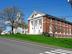
Notable sites:
Josiah Bronson House, built in 1738 and listed on the National Register of Historic Places in 1982
This page is based on this Wikipedia article Text is available under the CC BY-SA 4.0 license; additional terms may apply. Images, videos and audio are available under their respective licenses.