Al-Nabi Yusha' النبي يوشع | |
---|---|
Village | |
Aerial shot of the historic Maqam an-Nabi Yusha' shrine in 2013 | |
Etymology: "the prophet Joshua" [1] | |
A series of historical maps of the area around Al-Nabi Yusha' (click the buttons) | |
Location within Mandatory Palestine | |
Coordinates: 33°06′46″N35°33′22″E / 33.11278°N 35.55611°E | |
Palestine grid | 202/279 |
Geopolitical entity | Mandatory Palestine |
Subdistrict | Safad |
Date of depopulation | May 16, 1948 [2] |
Area | |
• Total | 3,617 dunams (3.617 km2 or 1.397 sq mi) |
Population (1945) | |
• Total | 70 [4] [3] |
Cause(s) of depopulation | Military assault by Yishuv forces |
Current Localities | Ramot Naftali |
Al-Nabi Yusha' (Arabic : النبي يوشع) was a small Palestinian village in the Galilee situated 17 kilometers to the northeast of Safad, with an elevation of 375 meters above sea level. It became part of the Palestine Mandate under British control from 1923 until 1948, when it was depopulated during the 1948 Arab-Israeli War. The village was surrounded by forest land overlooking the Hula Valley.
During the late eighteenth century, a family known as al-Ghul built the religious complex and shrine known as the Maqam an-Nabi Yusha' (biblical Joshua), which included a mosque and a building for visitors, as an act of devotion. This family, also called the "servants of the shrine," numbered about fifty and were the first to settle the site. They cultivated the surrounding land, and the place subsequently evolved into a village. [5]
In 1851/1852 van de Velde noted the wali at Al-Nabi Yusha, with an old terebinth tree. [6]
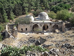
In 1875 Victor Guérin arrived at the Maqam (shrine) after walking up on a very steep and difficult path from the east. He described the shrine, dedicated by the local Muslims to Nabi Yusha', as a building surmounted with two small cupolas. [7] [8]
In 1881, the PEF's Survey of Western Palestine (SWP) noted that the "Metawali" from nearby Qadas came to Al-Nabi Yusha' to venerate the name of Joshua. [9]
Pottery from Rachaya Al Foukhar have been found in the village. [10]
At the end of World War I it was under French control, and the 1920 boundary agreement between Britain and French placed it in Lebanon. [8] At the time of the census conducted by the French in 1921, the villagers were granted Lebanese citizenship. [11] However the Boundary Commission established by the 1920 agreement shifted the border, leaving the village in Palestine. [8] Transfer of control to the British authorities was not complete until 1924. [12]
During the Mandate period, the British built a police station in the village. [5] The people of al-Nabi Yusha', all of whom were Shia Muslims, held an annual mawsim (pilgrimage) and festival on the fifteenth of the month Sha'aban (the eighth month of the Islamic calendar). The mawsim was similar to that of the Nabi Rubin festival in southern coast of Palestine. [5]
In the 1931 census of Palestine, the village was home to 52 residents that year (12 households), [13] growing to 70 in the 1945 statistics, [4] [3] and 81 (18 households) by 1948 when it was depopulated. The village occupied an area of 3,617 dunams, all private except for a dunam of public property. [3] In 1944–45 the village had 640 dunams of land used for cereals, [5] [14] while 16 dunams was built-up (urban) area. [15]
Al-Nabi Yusha' was depopulated on May 16, in the 1948 Arab-Israeli War during Operation Yiftach led by Israeli army officer Yigal Allon who later became a key Israeli figure. An early attempt to take the village by Haganah forces during the operation ended in the deaths of 22 Haganah fighters, who had their corpses reportedly decapitated by the Arab forces. [16]
Most of its residents ended up in refugee camps in Lebanon and Syria. In 1998, the descendants of al-Nabi Yusha' refugees were estimated at 499.[ citation needed ]
The Israeli moshav Ramot Naftali was established in 1945 south of the village, and since 1948 includes Al-Nabi Yusha' land. It is located close to the border between Al-Nabi Yusha' and the lands of Mallaha. [5] [17]
The Palestinian historian Walid Khalidi described the village remains in 1992 as: "The site has been fenced in with barbed wire and is buried under rubble, making access difficult. However, some evidence of the village remains: fragments of houses, tombs in the village's cemetery, and the shrine of al-Nabi Yusha'. The two domes and arched entrance of the main part of the shrine are still intact, but the thick stone walls of the rooms attached to it are broken and the entire complex of buildings is neglected; weeds sprouts from the roof. The village site is surrounded by fig trees and cactuses. The flat lands around the site are planted by Israeli farmers with apple trees, while the sloping parts are wooded or used as pasture." [18]
The shrine was surveyed by the British School of Archaeology in 1994, who described it as rectangular structure formed around a courtyard, aligned north-south, which was entered through a gateway on the north end. The principal rooms were at the south end of the courtyard, with two major domed chambers, of which the west chamber was found to be the oldest in the whole shrine complex. [19]
Alternative traditional sites for the Prophet's tomb are situated in Turkey (the shrine on Joshua's Hill, Istanbul), Jordan (An-Nabi Yusha' bin Noon, a Sunni shrine near the city of Al-Salt [20] [21] ) and Iraq (the Nabi Yusha' shrine of Baghdad [20] ).
Al-Mansura, was a Palestinian village that was depopulated by the Israeli army during the 1948 Arab-Israeli war. In 1945, it had a population of 2,300 together with the neighboring villages of Dayr al-Qassi and Fassuta. The population was predominantly Christian and most its residents live in what is now the state of Israel.
Al-Nabi Rubin, was a Palestinian village located 28 kilometers northeast of Acre. Al-Nabi Rubin students used to attend school in the nearby village of Tarbikha.
Suruh, was a Palestinian Arab hamlet, located 28.5 kilometers (17.7 mi) northeast of Acre. It became depopulated in the 1948 Arab-Israeli war.
Tarbikha, was a Palestinian Arab village. It was located 27 kilometres northeast of Acre in the British Mandate District of Acre that was captured and depopulated by the Israel Defense Forces during the 1948 Arab-Israeli war. The inhabitants of this village were, similar to the inhabitants of Southern Lebanon, Shia Muslims.
Al-Malkiyya, also known as Al-Malikiyah, was a Palestinian village located in the Jabal Amil region. In a 1920s census, the village was registered as part of Greater Lebanon. It was later placed under the British Mandate of Palestine. Its population was mostly Metawali Shiite.
Sar'a, was a Palestinian Arab village located 25 km west of Jerusalem, depopulated in the 1948 war. The site lies on a hill, at an elevation of about 1,150 feet (350 m) above sea-level.
Nabi Rubin was a town depopulated during the 1947–1949 Palestine war in Palestine, now Israel, located 14.5 kilometers (9.0 mi) west of Ramla, just northeast of Yibna, and 18 kilometers (11 mi) south of Jaffa. The village was situated on the southern banks of the Nahal Sorek/Wadi al-Sarar at an elevation of 25 meters (82 ft) above sea level.
Abil al-Qamh was a Palestinian village located near the Lebanese border north of Safad. It was depopulated in 1948. It was located at the site of the biblical city of Abel-beth-maachah.
Shahma was a Palestinian Arab village located 15 kilometers (9.3 mi) southwest of Ramla. Depopulated on the eve of the 1948 Arab-Israeli war, the village lands today form part of a fenced-in area used by the Israeli Air Force.
Arab al-Fuqara was a Palestinian Arab village in the Haifa Subdistrict. It was depopulated during the 1947–1948 Civil War in Mandatory Palestine on April 10, 1948. At that time, the land records of the village consisted of a total area of 2,714 dunams, of which 2,513 were owned by Jews, 15 owned by Arabs, and the remaining 186 dunams being public lands.
Bayt Umm al-Mays was a small Palestinian Arab village in the Jerusalem Sub-district, located 14 km west of Jerusalem..
Dayr Rafat was a Palestinian Arab village in the Jerusalem Subdistrict. It was located 26 km west of Jerusalem. It was depopulated during the 1948 Arab–Israeli War by the Harel Brigade.
Sufla was a Palestinian Arab village in the Jerusalem Subdistrict. It was depopulated during the 1948 Arab–Israeli War on October 19, 1948, by the Sixth Battalion of the Harel Brigade under Operation Ha-Har. It was located 18.5 km west of Jerusalem.
Daniyal was a Palestinian village in the Ramle Subdistrict that was located 5 km east of Ramla and southeast of Lydda. It was depopulated during the 1948 Arab–Israeli War on July 10, 1948, by the Yiftach Brigade under the first phase of Operation Dani, as part of the broader 1948 Palestinian expulsion and flight and Nakba.
Dayr Abu Salama was a small Palestinian Arab village in the Ramle Subdistrict, located 8 km northeast of Ramla. It was depopulated during the 1948 Arab–Israeli War on July 13, 1948, in the first phase of Operation Dani.
Al-'Abisiyya was a Palestinian Arab village in the District of Safad. It was depopulated during the 1948 Arab-Israeli War on May 29, 1948, by The Palmach's First Battalion of Operation Yiftach. It was located 28.5 km northeast of Safad near to the Banyas River which the village relied on for irrigation.
Harrawi was a Palestinian Arab village in the Safad Subdistrict. It was depopulated during the 1948 Arab-Israeli War on May 25, 1948, by the Palmach's First Battalion of Operation Yiftach. It was located 18 km northeast of Safad.
Sabalan was a Palestinian Arab village in the Safad Subdistrict, located 15.5 kilometers (9.6 mi) northwest of Safad. It stood at an elevation of 800 meters (2,600 ft) above sea level overlooking the Druze village of Hurfeish. In 1945, Sabalan had a population of 70. It was depopulated during the 1948 Palestine War.
Al-Qudayriyya was a Palestinian Arab village in the Safad Subdistrict. It was depopulated during the 1947–1948 Civil War in Mandatory Palestine on May 4, 1948, by the Haganah and the Palmach's First Battalion of Operation Matate, a sub-operation of Operation Yiftach. It was located 6.5 km south of Safad, situated 1 km east of Wadi al-'Amud.
Al-'Ubaydiyya was a Palestinian Arab village in the Tiberias Subdistrict. It was depopulated during the 1948 Arab-Israeli War on March 3, 1948. It was located 11 km south of Tiberias, situated close to the Jordan River.
{{cite journal}}
: Cite journal requires |journal=
(help)