Craig County, Virginia

Last updated

Craig County
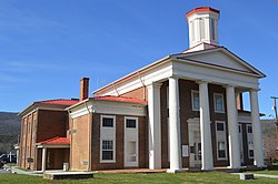
Craig County Courthouse, New Castle.jpg
Craig County Courthouse in New Castle
Seal of Craig County, Virginia.png
Logo of Craig County, Virginia.png
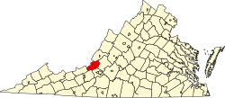
Map of Virginia highlighting Craig County.svg
Location within the U.S. state of Virginia
Virginia in United States.svg
Virginia's location within the U.S.
Coordinates: 37°29′N80°13′W / 37.49°N 80.22°W / 37.49; -80.22
CountryFlag of the United States.svg United States
StateFlag of Virginia.svg  Virginia
Founded1851
Named for Robert Craig
Seat New Castle
Largest townNew Castle
Area
  Total
331 sq mi (860 km2)
  Land330 sq mi (900 km2)
  Water1.1 sq mi (3 km2)  0.3%
Population
 (2020)
  Total
4,892
  Density15/sq mi (5.7/km2)
Time zone UTC−5 (Eastern)
  Summer (DST) UTC−4 (EDT)
Congressional district 9th
Website www.craigcountyva.gov

Craig County is a county located in the Commonwealth of Virginia. As of the 2020 census, the population was 4,892. [1] Its county seat is New Castle. [2]

Contents

Craig County is part of the Roanoke, VA Metropolitan Statistical Area.

History

Nestled in the mountains of Southwest Virginia, Craig County was named for Robert Craig, a 19th-century Virginia congressman. [3] The initial outpost in the area was called "Craig's Camp," and it is claimed that George Washington visited it in 1756 during his travels to the frontier. [4] Formed from parts of Botetourt, Roanoke, Giles, and Monroe (in present-day West Virginia) counties in 1851, Craig was later enlarged with several subsequent additions from neighboring counties. [5]

The secluded, mountainous New Castle community, the county seat, has one of the commonwealth's antebellum court complexes, including a porticoed courthouse built in 1852. [6] Craig Healing Springs, a collection of well-preserved early-20th-century resort buildings representative of the architecture of Virginia's more modest mountain spas, is located here. [7] [8]

Geography

According to the U.S. Census Bureau, the county has a total area of 330.6 square miles (856.3 km2), of which 329.5 square miles (853.4 km2) is land and 1.1 square miles (2.8 km2) (0.3%) is water. [9] Most of the county is national forest. Craig County is one of the 423 counties served by the Appalachian Regional Commission, [10] and it is identified as part of "Greater Appalachia" by Colin Woodard in his book American Nations: A History of the Eleven Rival Regional Cultures of North America . [11]

Adjacent counties

National protected area

Major highways

Demographics

Historical population
CensusPop.Note
1860 3,553
1870 2,942−17.2%
1880 3,79429.0%
1890 3,8351.1%
1900 4,29311.9%
1910 4,7119.7%
1920 4,100−13.0%
1930 3,562−13.1%
1940 3,7695.8%
1950 3,452−8.4%
1960 3,356−2.8%
1970 3,5245.0%
1980 3,94812.0%
1990 4,37210.7%
2000 5,09116.4%
2010 5,1901.9%
2020 4,892−5.7%
U.S. Decennial Census [12]
1790–1960 [13] 1900–1990 [14]
1990–2000 [15] 2010 [16] 2020 [17]

2020 census

Craig County, Virginia – Racial and ethnic composition
Note: the US Census treats Hispanic/Latino as an ethnic category. This table excludes Latinos from the racial categories and assigns them to a separate category. Hispanics/Latinos may be of any race.
Race / Ethnicity (NH = Non-Hispanic)Pop 2010 [16] Pop 2020 [17] % 2010% 2020
White alone (NH)5,1034,63198.32%94.66%
Black or African American alone (NH)5110.10%0.22%
Native American or Alaska Native alone (NH)650.12%0.10%
Asian alone (NH)8110.15%0.22%
Pacific Islander alone (NH)030.00%0.06%
Some Other Race alone (NH)1120.02%0.25%
Mixed Race or Multi-Racial (NH)311660.60%3.39%
Hispanic or Latino (any race)36530.69%1.08%
Total5,1904,892100.00%100.00%

2000 Census

As of the census [18] of 2000, there were 5,091 people, 2,060 households, and 1,507 families residing in the county. The population density was 15 people per square mile (5.8 people/km2). There were 2,554 housing units at an average density of 8 units per square mile (3.1 units/km2). The racial makeup of the county was 98.94% White, 0.20% Black or African American, 0.22% Native American, 0.16% Asian, 0.14% from other races, and 0.35% from two or more races. 0.33% of the population were Hispanic or Latino of any race.

There were 2,060 households, out of which 30.80% had children under the age of 18 living with them, 61.90% were married couples living together, 7.00% had a female householder with no husband present, and 26.80% were non-families. 23.90% of all households were made up of individuals, and 10.50% had someone living alone who was 65 years of age or older. The average household size was 2.45 and the average family size was 2.88.

In the county, the population was spread out, with 23.60% under the age of 18, 6.40% from 18 to 24, 29.70% from 25 to 44, 26.70% from 45 to 64, and 13.60% who were 65 years of age or older. The median age was 40 years. For every 100 females there were 103.40 males. For every 100 females age 18 and over, there were 101.50 males.

The median income for a household in the county was $37,314, and the median income for a family was $41,750. Males had a median income of $26,713 versus $21,337 for females. The per capita income for the county was $17,322. About 6.60% of families and 10.30% of the population were below the poverty line, including 15.90% of those under age 18 and 10.50% of those age 65 or over.
Government

Board of Supervisors

Constitutional officers

Craig County is represented by Republican Stephen D. "Steve" Newman in the Virginia Senate, Republican Joe McNamara in the Virginia House of Delegates, and Republican H. Morgan Griffith in the U.S. House of Representatives.

Politics

United States presidential election results for Craig County, Virginia [21]
Year Republican Democratic Third party(ies)
No.%No.%No.%
2024 2,56282.12%54217.37%160.51%
2020 2,53680.03%58718.52%461.45%
2016 2,14076.68%54119.38%1103.94%
2012 1,75765.88%83031.12%803.00%
2008 1,69564.67%87733.46%491.87%
2004 1,70665.09%90134.38%140.53%
2000 1,58063.38%85134.14%622.49%
1996 97945.35%89541.45%28513.20%
1992 1,00843.88%96542.01%32414.11%
1988 1,11255.46%86443.09%291.45%
1984 1,17357.70%84541.56%150.74%
1980 76843.17%94653.18%653.65%
1976 54632.75%1,10366.17%181.08%
1972 77463.44%42534.84%211.72%
1968 58146.18%41933.31%25820.51%
1964 47738.34%76761.66%00.00%
1960 43344.78%53455.22%00.00%
1956 48548.84%50150.45%70.70%
1952 42546.45%49053.55%00.00%
1948 31739.82%45657.29%232.89%
1944 32736.66%56463.23%10.11%
1940 29931.24%65668.55%20.21%
1936 39537.65%65362.25%10.10%
1932 30231.26%64967.18%151.55%
1928 45147.98%48952.02%00.00%
1924 30036.01%51261.46%212.52%
1920 31545.06%38154.51%30.43%
1916 20035.03%36964.62%20.35%
1912 6211.19%33760.83%15527.98%

Communities

Town

Unincorporated communities

See also

Related Research Articles

<span class="mw-page-title-main">Montgomery County, Virginia</span> County in Virginia, United States

Montgomery County is a county located in the Valley and Ridge area of the U.S. state of Virginia. As population in the area increased, Montgomery County was formed in 1777 from Fincastle County, which in turn had been taken from Botetourt County. As of the 2020 census, the population was 99,721. Its county seat is Christiansburg, and Blacksburg is the largest town. Montgomery County is part of the Blacksburg-Christiansburg metropolitan area. It is dominated economically by the presence of Virginia Tech, Virginia's third largest public university, which is the county's largest employer.

<span class="mw-page-title-main">Smyth County, Virginia</span> County in Virginia, United States

Smyth County is a county located in the U.S. state of Virginia. As of the 2020 census, the population was 29,800. Its county seat is Marion.

<span class="mw-page-title-main">Salem, Virginia</span> Independent city in Virginia, United States

Salem is an independent city in the U.S. commonwealth of Virginia. As of the 2020 census, the population was 25,346. It is the county seat of Roanoke County, although the two are separate jurisdictions. The Bureau of Economic Analysis combines the city of Salem with Roanoke County, which surrounds both Salem and the neighboring City of Roanoke, for statistical purposes. Salem has its own courthouse and sheriff's office, but shares a jail with Roanoke County, which is located in the Roanoke County Courthouse complex in Salem. The Roanoke County Sheriff's Office and Roanoke County Department of Social Services are also located within Salem, though the county administrative offices are located in unincorporated Cave Spring.

<span class="mw-page-title-main">Russell County, Virginia</span> County in Virginia, United States

Russell County is a county located in the Commonwealth of Virginia. As of the 2020 census, the population was 25,781. Its county seat is Lebanon.

<span class="mw-page-title-main">Roanoke County, Virginia</span> County in the United States

Roanoke County is a county in the U.S. state of the Commonwealth of Virginia. As of the 2020 census, its population was 96,929. Its county seat is Salem, but the county administrative offices are located in the census-designated place of Cave Spring.

<span class="mw-page-title-main">Pulaski County, Virginia</span> County in Virginia, United States

Pulaski County is a county located in the southwestern part of the U.S. state of Virginia. As of the 2020 census, the population was 33,800. Its county seat is Pulaski. Pulaski County is part of the Blacksburg–Christiansburg, VA Metropolitan Statistical Area.

<span class="mw-page-title-main">Floyd County, Virginia</span> County in Virginia, United States

Floyd County is a county located in the Commonwealth of Virginia. As of the 2020 census, the population was 15,476. Its county seat is the town of Floyd. Floyd County is included in the Blacksburg-Christiansburg, VA Metropolitan Statistical Area.

<span class="mw-page-title-main">Buchanan County, Virginia</span> County in Virginia, United States

Buchanan County is a United States county in far western Virginia, the only county in the state to border both West Virginia and Kentucky. The county is part of the Southwest Virginia region and lies in the rugged Appalachian Plateau portion of the Appalachian Mountains. Its county seat is Grundy. Buchanan County was established in 1858 from parts of Russell and Tazewell counties, and it was named in honor of then-President James Buchanan. Local pronunciation differs from that of the 15th president's surname; here the county is pronounced as "Búh-can-nin". In 1880, part of Buchanan County was taken to form Dickenson County.

<span class="mw-page-title-main">Botetourt County, Virginia</span> County in Virginia, United States

Botetourt County is a US county that lies in the Roanoke Region of Virginia. Located in the mountainous portion of the state, the county is bordered by two major ranges, the Blue Ridge Mountains and the Appalachian Mountains.

<span class="mw-page-title-main">Bath County, Virginia</span> County in Virginia, United States

Bath County is a United States county on the central western border of the Commonwealth of Virginia, on the West Virginia state line. As of the 2020 census, the population was 4,209, the second-least populous county in Virginia. Bath's county seat is Warm Springs.

<span class="mw-page-title-main">Alleghany County, Virginia</span> County in Virginia, United States

Alleghany County is an American county located on the far western edge of Commonwealth of Virginia. It is bordered by the Allegheny Mountains, from which the county derives its name, and it is the northernmost part of the Roanoke Region. The county seat is Covington. As of the 2020 census, the population was 15,223.

<span class="mw-page-title-main">Blue Ridge, Virginia</span> Census-designated place in Virginia, United States

Blue Ridge is a census-designated place (CDP) in southern Botetourt County, Virginia, United States. The population was 3,185 at the 2020 census. The CDP is located along U.S. Route 460. It is part of the Roanoke Metropolitan Statistical Area.

<span class="mw-page-title-main">Buchanan, Virginia</span> Town in Virginia, United States

Buchanan is a town in Botetourt County, Virginia, United States. The population was 1,196 at the 2020 census. It is part of the Roanoke Metropolitan Statistical Area. It was the western terminus of the James River and Kanawha Canal when construction on the canal ended.

Cloverdale is a census-designated place (CDP) in southern Botetourt County, Virginia, United States. The population was 3,410 at the 2020 census. The community is located along State Route 654. It is part of the Roanoke Metropolitan Statistical Area.

Daleville is a census-designated place (CDP) in southern Botetourt County, Virginia, United States. The population was 3,070 at the 2020 census. The CDP is located along U.S. Route 220. It is part of the Roanoke Metropolitan Statistical Area.

<span class="mw-page-title-main">Fincastle, Virginia</span> Town in Virginia, United States

Fincastle is a town in Botetourt County, Virginia, United States. The population was 755 at the 2020 census. It is the county seat of Botetourt County.

Laymantown is a census-designated place (CDP) in southern Botetourt County, Virginia, United States. The population was 1,867 at the 2020 census. The community is located along State Route 658. It is part of the Roanoke Metropolitan Statistical Area.

<span class="mw-page-title-main">Troutville, Virginia</span> Town in Virginia, United States

Troutville is a town in Botetourt County, Virginia, United States. The population was 458 at the 2020 census. The town is located along the U.S. Route 11 between Cloverdale and Buchanan. It is part of the Roanoke Metropolitan Statistical Area.

Hollins is a census-designated place (CDP) in Botetourt and Roanoke County, Virginia, United States. Hollins covers much of the area known locally as "North County". The population was 15,574 at the 2020 census. It is part of the Roanoke Metropolitan Statistical Area. The area is also the home of Hollins University in addition to four properties listed on the National Register of Historic Places: the Black Horse Tavern-Bellvue Hotel and Office, Harshbarger House, the Hollins College Quadrangle, and Old Tombstone.

<span class="mw-page-title-main">Roanoke metropolitan area</span> Metropolitan area in Virginia, United States

The Roanoke Metropolitan Statistical Area is a Metropolitan Statistical Area (MSA) in Virginia as defined by the United States Office of Management and Budget (OMB). The Roanoke MSA is sometimes referred to as the Roanoke Valley, even though the Roanoke MSA occupies a larger area than the Roanoke Valley. It is geographically similar to the area known as the Roanoke Region of Virginia, but while the latter includes Alleghany County, the former does not. As of the 2020 census, the MSA had a population of 315,251.

References

  1. "Craig County, Virginia". United States Census Bureau . Retrieved January 30, 2022.
  2. "Find a County". National Association of Counties. Archived from the original on May 31, 2011. Retrieved June 7, 2011.
  3. "Craig County Virginia". Iberian Publishing Company's On-Line Catalog. Retrieved March 2, 2024.
  4. "History of Craig County | Craig County, VA" . Retrieved April 5, 2021.
  5. "History of Craig County". Craig County. Retrieved March 2, 2024.
  6. "Craig County Courthouse". Virginia Mountains. Retrieved March 2, 2024.
  7. "Craig Healing Springs" (PDF). National Register of Historic Places. Archived from the original (PDF) on August 13, 2013. Retrieved March 2, 2024.
  8. "Craig Healing Springs". Historic Registers. Retrieved March 2, 2024.
  9. "US Gazetteer files: 2010, 2000, and 1990". United States Census Bureau. February 12, 2011. Retrieved April 23, 2011.
  10. "About the Appalachian Region". Appalachian Regional Commission. Retrieved June 21, 2024.
  11. Woodard, Colin. "The Maps That Show That City vs. Country Is Not Our Political Fault Line". New York Times. Retrieved July 30, 2018.
  12. "Census of Population and Housing from 1790-2000". US Census Bureau . Retrieved January 24, 2022.
  13. "Historical Census Browser". University of Virginia Library. Archived from the original on August 11, 2012. Retrieved January 1, 2014.
  14. "Population of Counties by Decennial Census: 1900 to 1990". United States Census Bureau. Retrieved January 1, 2014.
  15. "Census 2000 PHC-T-4. Ranking Tables for Counties: 1990 and 2000" (PDF). United States Census Bureau. Archived (PDF) from the original on October 9, 2022. Retrieved January 1, 2014.
  16. 1 2 "P2 Hispanic or Latino, and Not Hispanic or Latino by Race –2010: DEC Redistricting Data (PL 94-171) - Craig County, Virginia". United States Census Bureau .
  17. 1 2 "P2 Hispanic or Latino, and Not Hispanic or Latino by Race – 2020: DEC Redistricting Data (PL 94-171) - Craig County, Virginia". United States Census Bureau .
  18. "U.S. Census website". United States Census Bureau . Retrieved May 14, 2011.
  19. "Board of Supervisors". Community and Government Portal. Craig County. Retrieved September 7, 2016.
  20. "Elected Officials". Community and Government Portal. Craig County. Retrieved September 7, 2016.
  21. Leip, David. "Dave Leip's Atlas of U.S. Presidential Elections". uselectionatlas.org. Retrieved December 9, 2020.

37°29′N80°13′W / 37.49°N 80.22°W / 37.49; -80.22