Khirbat Al-Burj was a former Palestinian village, depopulated in 1948.[2] Presently, Khirbat Al-Burj (lit. "ruin of the tower") or Burj Binyamina is a ruined stone-built structure in the Sharon Plain 1km south of Binyamina from the Ottoman period.[3] It is one of the estates established around Qisarya (Caesarea), alongside al-Manshiya, al-Sufsafa, and Hudaydun.[4]
During June 2009, archeological excavations in the courtyard of the Burj building from the Ottoman period exposed a small building that dated to the Byzantine period (5th–7th centuries CE).[3] Byzantine ceramics have been found at the structure.[5]
Crusader period
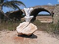
Burj Binyamina plaque
A stone with Greek inscription was found at the burj site, which has been reused in a Crusader fortress.[5][dubious–discuss]
Gottlieb Schumacher found in 1887 that the site had been settled since the PEF map was prepared, now consisting of "12 huts, moderate village".[7] A population list from about 1887 give for that place, called Burj el Kheil, about 105 inhabitants; all Muslims.[8]
Turkish owner, Sidki Pasha, brother of Jamal Pasha, sold 4,000 dunams of the Burj farmland to ICA in 1903.[9] The serious drawback was that most of the land was an uncultivable swamp.[10]Rothschild turned the land over to Binyamina's holdings.[10] Initially a group of farmers from Zichron Ya'akov stayed at the khan during the week, due to the distance to their hometown. The group was called Burja’im.[3]
Binyamina (1922)
Subsequently, Binyamina was founded.[3] A letter from early 1920s describes establishment of Binyamina: "The 'Zichronim' [people of Zichron Ya'akov] owners of Burj farm decided to establish a moshavah in this farm, in order to settle their sons there…".[11]
Kirbar al-Burj in 1942
Burj became Binyamina in 1922.[9] In the 1931 census Khirbat Al-Burj was listed under Binyamina.[12] The ownership of the village land was determined in 1934 according to the Land Settlement Ordinances.[13]
By the time of the 1945 village survey, there were 5,291 dunums, 15 of which were owned by Arabs, 4,933 owned by Jews, and 343 were public.[14][15]
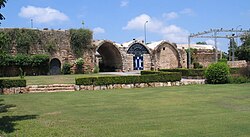
The building, after renovations, now operates as an event venue.[16]
Arab population issue
In the 1945 Index Gazetteer, Khirbat Al-Burj was listed as a "village unit" but "no population".[17] According to Frantzman, the 1:20,000 map (produced 1924-1948) shows "a large structure, akin to a khan with no indication that it was populated".[17] According to Khalidi, Khirbat Al-Burj was a Palestinian village which was depopulated by Israelis in 1948.[2] Khalidi also says the "village" was "known for its citrus crops" and situated on "rolling terrain".[17]
Agriculture
The red sandy clay loam (hamra) soils from Binyamina to Gedera, west of the coastal plain, were not cultivated till the 20th century.[18] The original economy of Binyamina was citrus-based.[19]
Gallery
See also
Tel Burga - archeological site 1km east of Binyamina, just outside the village land of Khirbat Al-Burj.[20]
↑ Government of Palestine, The Palestine Gazette, Supplement 2 to Issue 475, 8 November 1934, p. 953.
↑ Government of Palestine, Department of Statistics. Village Statistics, April, 1945. Quoted in Hadawi, 1970, p. 48Archived 2017-08-11 at the Wayback Machine
↑ Government of Palestine, Department of Statistics, 1945, p. 14
1 2 3 "The Arab settlement of Late Ottoman and Mandatory Palestine: New Village Formation and Settlement Fixation, 1871-1948", Seth J. Frantzman, pp.71-72
↑ The Jewish people in the first century: historical geography, political history, social, cultural and religious life and institutions. Vol. 2, by Samuel Safrai; M Stern, page 640
↑ Jewish National Fund (1949). Jewish Villages in Israel. Jerusalem: Hamadpis Liphshitz Press. p.24.
This page is based on this Wikipedia article Text is available under the CC BY-SA 4.0 license; additional terms may apply. Images, videos and audio are available under their respective licenses.
 1870s map
  1940s map
 modern map
  1940s with modern overlay map


