Poncha Springs, Colorado

Last updated

Town of Poncha Springs, Colorado
Poncha Springs Schoolhouse.JPG
The Poncha Springs Town Hall, formerly a school
Nickname: 
Crossroads of the Rockies
Chaffee County Colorado Incorporated and Unincorporated areas Poncha Springs Highlighted 0860600.svg
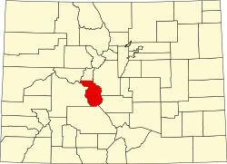
Location of Poncha Springs in Chaffee County, Colorado.
Coordinates: 38°30′34″N106°07′32″W / 38.50944°N 106.12556°W / 38.50944; -106.12556
Country Flag of the United States (23px).png  United States
State Flag of Colorado.svg  Colorado
County [1] Chaffee
Incorporated (town) December 16, 1880 [2]
Government
  Type Statutory Town [1]
   Mayor Ben Scanga[ citation needed ]
Area
[3]
  Total2.98 sq mi (7.73 km2)
  Land2.98 sq mi (7.73 km2)
  Water0.00 sq mi (0.00 km2)
Elevation
[4]
7,477 ft (2,279 m)
Population
 (2024) [5]
  Total1,406
  Density470/sq mi (180/km2)
Time zone UTC-7 (Mountain (MST))
  Summer (DST) UTC-6 (MDT)
ZIP code [6]
81242 (PO Box)
Area code 719
FIPS code 08-60600
GNIS feature ID2412495 [4]
Website www.ponchaspringscolorado.us

Poncha Springs is a statutory town in Chaffee County, Colorado, United States. The population was 925 at the 2020 census. [5] It is 1406 as of 2024.

Contents

History

The Ute people used the Poncha Springs area as camping grounds during the winter months on the eve of European settlement of the region. Juan Bautista de Anza led a military expedition over Poncha Pass in 1779, which is about 6 miles (10 km) south of the present-day town. Following the Spanish exploration, French trappers and fur traders moved in. In 1855, Colonel Thomas T. Fauntleroy and the 1st Cavalry Regiment marched over Poncha Pass and engaged a group of Utes between present day Salida and Poncha Springs, during the Ute Wars.

Around 1860, prospectors began arriving, including Bob Hendricks and Nat Rich, who built the first cabin in town, which is still standing. Nat Rich's son, James, was the first white person born in Poncha Springs in 1867. That same year Poncha Springs was designated as an election precinct.

Indian agent John Burnett homesteaded with his wife, Minerva Maxwell Burnett, who was an early schoolteacher in Poncha Springs. In 1866, Burnett constructed a log building on his ranch to serve as an Indian trading post. The Hutchinson and McPherson families also homesteaded the area around the same time. John McPherson purchased Nat Rich's squatting rights from Joe Hutchinson and built a grocery store.

Poncha Springs began to grow in the 1870s, and was incorporated on December 8, 1880. The Poncha Springs Schoolhouse, which is listed on the National Register of Historic Places and served as the town hall until, In 2017, when the Town of Poncha Springs completed a long awaited new, purpose-built, town hall adjacent to the historic school house. As a result the school house, for the first time in its long history, became vacant. Chaffee Childcare Initiative turned it into a preschool, then in 2020 it was turned into the Ark Vally preschool. The Schoolhouse was completed in 1883.

Hot springs

The European discovery of the Poncha hot springs is widely disputed. Some historians believe Lt. Zebulon Pike, after whom Pikes Peak is named, made the discovery in 1806. Others credit frontiersman Kit Carson, who passed through Poncha Springs in 1832. John Burnett, Henry Weber, and Paul Irvine built the first spring-fed bath in 1868 by digging a large pit, which they lined with logs to contain the water. The town flourished when the railroad passed through, and the springs became a popular attraction. Two hotels were constructed on the site, but both burned down. In 1904, a year after the last fire, the Holman family arrived to manage the springs. By then a hand-plastered rock pool, two cabins, two baths, and a sleeping room had been built.

The springs were operated by Donald Hartwich from 1927 to 1935, when the City of Salida had the W.P.A. pipe the water to the pool in Salida. The springs were capped with cement and have since become property of the City of Salida.

Geography

The town has a total area of 2.98 square miles of land. [7]

Demographics

Historical population
CensusPop.Note
1880 170
1890 101−40.6%
1900 97−4.0%
1910 43−55.7%
1920 37−14.0%
1930 80116.2%
1940 9417.5%
1950 11421.3%
1960 20176.3%
1970 198−1.5%
1980 32162.1%
1990 244−24.0%
2000 46691.0%
2010 73758.2%
2020 92525.5%
U.S. Decennial Census

Transportation

Poncha Springs calls itself "Crossroads of the Rockies" due to the intersection of two main thoroughfares in the town. US 50 runs through the town east–west, while US 285 runs through north–south.

Poncha Springs is part of Colorado's Bustang bus network. It is on the Alamosa-Pueblo Outrider bus line. [8]

Tesla operates a supercharger station in the town.

See also

Related Research Articles

<span class="mw-page-title-main">Idaho Springs, Colorado</span> City in Colorado, United States

The City of Idaho Springs is the statutory city that is the most populous municipality in Clear Creek County, Colorado, United States. Idaho Springs is a part of the Denver–Aurora–Lakewood, CO Metropolitan Statistical Area. As of the 2020 census it had a population of 1,782. Idaho Springs is located in Clear Creek Canyon, in the mountains upstream from Golden, some 30 miles (50 km) west of Denver.

<span class="mw-page-title-main">Chaffee County, Colorado</span> County in Colorado, United States

Chaffee County is a county located in the U.S. state of Colorado. As of the 2020 census, the population was 19,476. The county seat is Salida.

<span class="mw-page-title-main">Buena Vista, Colorado</span> Town in Colorado, United States

Buena Vista is a statutory town located in Chaffee County, Colorado, United States. The town population was 2,855 at the 2020 United States Census.

<span class="mw-page-title-main">Salida, Colorado</span> City in Colorado, United States

Salida is the statutory city that is the county seat and the most populous municipality of Chaffee County, Colorado, United States. The population was 5,666 at the 2020 census.

<span class="mw-page-title-main">Delta, Colorado</span> City in Colorado, United States

Delta is a home rule municipality that is the county seat and the most populous municipality of Delta County, Colorado, United States. The town population was 9,035 at the 2020 United States Census. The United States Forest Service headquarters of the Grand Mesa, Gunnison, and Uncompahgre National Forests are located in Delta.

<span class="mw-page-title-main">Rico, Colorado</span> Town in Colorado, United States

Rico is a town in Dolores County, Colorado, United States. It was settled in 1879 as a silver mining center in the Pioneer Mining District; today it functions as a historic and tourism site. The population was 288 at the 2020 census. Its current form of government is that of a home rule municipality.

<span class="mw-page-title-main">Fountain, Colorado</span> City in Colorado, United States

The City of Fountain is a home rule municipality located in El Paso County, Colorado, United States. The population was 29,802 at the 2020 census. Fountain is a part of the Colorado Springs, CO Metropolitan Statistical Area and the Front Range Urban Corridor.

<span class="mw-page-title-main">Parachute, Colorado</span> Town in Colorado, United States

The Town of Parachute is a home rule municipality in Garfield County, Colorado, United States. The population was 1,390 at the 2020 census.

<span class="mw-page-title-main">Rifle, Colorado</span> City in Colorado, United States

Rifle is a home rule municipality in, and the most populous community of, Garfield County, Colorado, United States. The population was 10,437 at the 2020 census. Rifle is a regional center of the cattle ranching industry located along Interstate 70 and the Colorado River just east of the Roan Plateau, which dominates the western skyline of the town. The town was founded in 1882 by Abram Maxfield, and was incorporated in 1905 along Rifle Creek, near its mouth on the Colorado. The community takes its name from the creek.

<span class="mw-page-title-main">Hot Sulphur Springs, Colorado</span> Town in Colorado, United States

Hot Sulphur Springs is a statutory town and the county seat of Grand County, Colorado, United States. The town is located near Byers Canyon between Granby and Kremmling, 95 miles (153 km) northwest of Denver and 30 miles (48 km) northwest of Winter Park. The town population was 687 at the 2020 census. Its elevation is 7,680 feet (2,340 m).

<span class="mw-page-title-main">Cortez, Colorado</span> City in Colorado, United States

Cortez is a home rule municipality that is the county seat and the most populous municipality of Montezuma County, Colorado, United States. The city population was 8,766 at the 2020 United States Census.

<span class="mw-page-title-main">Dolores, Colorado</span> Town in Montezuma County, Colorado, United States

Dolores is a Statutory Town located in Montezuma County, Colorado, United States. The town population was 885 at the 2020 United States Census.

<span class="mw-page-title-main">Frisco, Colorado</span> Town in Colorado, United States

Frisco is a home rule municipality located in Summit County, Colorado, United States. The population was 2,913 at the 2020 census. Frisco is a part of the Breckenridge, CO Micropolitan Statistical Area. It is a popular town among skiers from around the world. Four major ski resorts are located in close proximity to Frisco: Copper Mountain, Breckenridge, Keystone, and Arapahoe Basin.

<span class="mw-page-title-main">Poncha Pass</span> Low point in the Rockies in southern Colorado

Poncha Pass is a mountain pass in South-Central Colorado (USA). It lies between the San Luis Valley to the south and the valley of the Arkansas River to the north, and is one of the lowest mountain passes in the state. It is in the saddle between the Sangre de Cristo Range, lying to the southeast, and the Sawatch Range, lying to the west and northwest. The small town of Poncha Springs lies about 6 miles (9.7 km) north of the pass. The pass has a mild approach on the northern side and a moderate 5% approach from the south, though it remains open all year round and does not normally cause problems for vehicles in winter.

<span class="mw-page-title-main">Placerville, Colorado</span> Census-designated place in San Miguel County, Colorado, United States

Placerville is a census-designated place (CDP) and post office in and governed by San Miguel County, Colorado, United States. The Placerville post office has the ZIP Code 81430. At the United States Census 2020, the population of the Placerville CDP was 362.

<span class="mw-page-title-main">Cascade, Colorado</span> Unincorporated community in Colorado, United States

Cascade is an unincorporated community and U.S. Post Office in El Paso County, Colorado, United States. The ZIP Code of the Cascade Post Office is 80809.

<span class="mw-page-title-main">Granite, Colorado</span> Unincorporated community in Colorado, United States

Granite is an unincorporated community with a U.S. Post Office in Chaffee County, Colorado, United States. The zip code of Granite is 81228. According to the 2010 census, the population is 116.

Hutchinson House, Hutchinson Homestead, or Hutchinson Farm, may refer to:

<span class="mw-page-title-main">Colorado State Highway 291</span> State highway in Colorado, United States

State Highway 291 (SH 291) is a 9.135-mile (14.701 km) state highway in Chaffee County, Colorado, United States, that connects U.S. Route 50 (US 50) in Salida with U.S. Route 285 (US 285) north of Poncha Springs.

<span class="mw-page-title-main">Poncha Springs Schoolhouse</span> United States historic place

The Poncha Springs Schoolhouse, at 330 Burnett St. near Poncha Springs, Colorado in Chaffee County, Colorado, was built in Italianate style during 1881–83. It was listed on the National Register of Historic Places in 1990. It was then the Poncha Springs Town Hall and Museum.

References

  1. 1 2 "Active Colorado Municipalities". State of Colorado, Department of Local Affairs. Archived from the original on December 12, 2009. Retrieved September 1, 2007.
  2. "Colorado Municipal Incorporations". State of Colorado, Department of Personnel & Administration, Colorado State Archives. December 1, 2004. Retrieved September 2, 2007.
  3. "2019 U.S. Gazetteer Files". United States Census Bureau. Retrieved July 1, 2020.
  4. 1 2 U.S. Geological Survey Geographic Names Information System: Poncha Springs, Colorado
  5. 1 2 United States Census Bureau. "Poncha Springs town; Colorado" . Retrieved April 28, 2023.
  6. "ZIP Code Lookup" (JavaScript/HTML). United States Postal Service . Retrieved December 15, 2007.
  7. "Geographic Identifiers: 2010 Demographic Profile Data (G001): Poncha Springs town, Colorado". U.S. Census Bureau, American Factfinder. Archived from the original on February 12, 2020. Retrieved June 20, 2014.
  8. "Bustang Schedule". RideBustang. CDOT.