Safsaf was a Palestinian village 9 kilometres northwest of Safed, present-day Israel. Its villagers fled to Lebanon after the Safsaf massacre in October 1948, during the 1948 Arab–Israeli War.
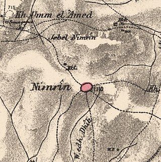
Nimrin was a Palestinian Arab town of 320 that was captured and depopulated by Israel during the 1948 Arab-Israeli War.
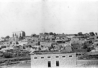
Al-Khalisa was a Palestinian Arab village situated on a low hill on the northwestern edge of the Hula Valley of over 1,800 located 28 kilometers (17 mi) north of Safad. It was depopulated in the 1948 Palestine war.

Ammuqa was a Palestinian village, located five kilometres northeast of Safed.

Ein al-Zeitun, was a Palestinian Arab village, located 1.5 kilometres (0.93 mi) north of Safed in the Upper Galilee. During the early Ottoman period, Ein el-Zeitun had a mixed population of Muslims and Jews. Later, in the 19th century, it became entirely Muslim. The village's small population and land area as well as its proximity to Safad made it a suburb of the city. In 1945, the village had a population of 820 inhabitants and a total land area of 1,100 dunams. The village was depopulated in 1948, after the Ein al-Zeitun massacre.

Qaddita was a Palestinian Arab village of 240, located 4.5 kilometers (2.8 mi) northwest of Safad. It was captured and depopulated in the 1948 Arab-Israeli War, with some of its inhabitants expelled or fleeing to nearby 'Akbara where they live as internally displaced Palestinians and others to refugee camps in Lebanon or Syria.

Abil al-Qamh was a Palestinian village located near the Lebanese border north of Safad. It was depopulated in 1948. It was located at the site of the biblical city of Abel-beth-maachah.

Al-Bira, is a depopulated former Palestinian village located 7.5 km north of Baysan. During Operation Gideon, the village was occupied by the Golani Brigade.

'Akbara is an Arab village in the Israeli municipality of Safed, which included in 2010 more than 200 families. It is 2.5 km south of Safed City. The village was rebuilt in 1977, close to the old village destroyed in 1948 during the 1947–1949 Palestine war.

Arab al-Shamalina also known as Khirbat Abu Zayna was a Palestinian Arab village in the Safad Subdistrict. It was depopulated during the 1947–1948 Civil War in Mandatory Palestine on May 4, 1948, under Operation Matate (Broom), a sub operation of Operation Yiftach. It was located 13 km southeast of Safad near the Jordan River.

Biriyya was a Palestinian Arab village in the Safad Subdistrict. It was depopulated during the 1947–1948 Civil War in Mandatory Palestine on May 2, 1948, by The Palmach's First Battalion of Operation Yiftach. It was located 1.5 kilometres (0.9 mi) northeast of Safad. Today the Israeli moshav of Birya includes the village site.

Dallata was an Arab village, located on a hilltop 6 kilometers (3.7 mi) north of Safad. Constructed upon an ancient site, it was known to the Crusaders as Deleha. Dallata was included in the late 16th century Ottoman census and British censuses of the 20th century. Its inhabitants were primarily agriculturalists, with some involved in carpentry or trade.

Fara was a Palestinian Arab village in the Safad Subdistrict. It was depopulated during the 1948 Arab-Israeli War on October 30, 1948, under Operation Hiram. It was located 11.5 km north of Safad on the Wadi al-Fara.

Fir'im was a Palestinian Arab village in the Safad Subdistrict that was depopulated during the 1948 Palestine war. It was first attacked during the 1947–1948 Civil War in Mandatory Palestine on May 2, 1948, by the Palmach's First Battalion during Operation Yiftach. In 1945 the population had been 740.

Jahula was a Palestinian Arab village in the Safad Subdistrict. It was depopulated during the 1947–1948 civil war in Mandatory Palestine on May 1, 1948, by the Palmach's First Battalion of Operation Yiftach. It was located 11 km northeast of Safad.

Al-Ras al-Ahmar was a Palestinian Arab village in the Safad Subdistrict. It was depopulated during the 1948 Arab–Israeli War on October 30, 1948, by the Israeli 7th Armored Brigade during Operation Hiram. It was located 8.5 km north of Safad.

Qabba'a was a Palestinian Arab village in the District of Safad. It was depopulated during the 1948 War on May 26, 1948, by the Palmach's First Battalion of Operation Yiftach. It was located 6 km northeast of Safad.
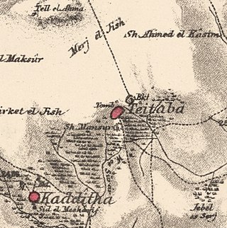
Taytaba was a Palestinian-Arab village in the Safad Subdistrict, located 5 kilometers north of Safad. It was depopulated during the 1947–1948 Civil War in Mandatory Palestine in May 1948 under Operation Hiram. In 1945 it had a population of 530 and a total area of 8,453 dunams, 99.8% of which was Arab-owned.

Tulayl was a Palestinian Arab village in the Safad Subdistrict located 14.5 kilometers (9.0 mi) northeast of Safad. It was situated on a hill near Lake Hula. Together with the nearby village of al-Husayniyya, it had a population of 340 in 1945. Tulayl was depopulated during the 1948 Palestine War.

Al-'Ulmaniyya was a Palestinian Arab village in the Safad Subdistrict. It was depopulated during the 1947–1948 Civil War in Mandatory Palestine on April 20, 1948, by the Palmach's First Battalion of Operation Yiftach. It was located 14.5 km northeast of Safad.

 1870s map
  1940s map
 modern map
  1940s with modern overlay map


