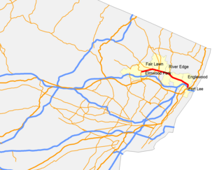
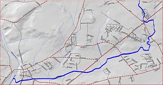
Route 4 is a state highway in Bergen County and Passaic County, New Jersey, United States. The highway stretches 10.83 mi (17.43 km) from Route 20 in Paterson east to an interchange with Interstate 95, U.S. Route 1/9, U.S. Route 46, and U.S. Route 9W at the George Washington Bridge approach in Fort Lee.

The Millstone River is a 38.6-mile-long (62.1 km) tributary of the Raritan River in central New Jersey in the United States.
Heathcote Brook, also known as Heathcote Run, is a tributary of the Millstone River in central New Jersey in the United States.

Holmeson is an unincorporated community located within Millstone Township in Monmouth County, New Jersey, United States. As it is located along County Route 537 through which the Monmouth–Ocean county line runs down the center, portions of the community are also located in Jackson Township. Owing to its location near Interstate 195 and Six Flags Great Adventure, the community is mostly made up of gas stations, restaurants, and small businesses though the Jackson Premium Outlets occupies land just south of the community.

Millhurst is an unincorporated community located within Manalapan Township in Monmouth County, New Jersey, United States. Route 33 and County Route 527 pass through the center of Millhurst. Much of the area consists of businesses along the aforementioned arterial roads with the Millhurst Mill at the CR 527 crossing of Manalapan Brook. The mill is a former grist mill built in the 1700s, rebuilt in the 1800s as a more efficient mill, and turned into a family business by Bernard Hochberg in 1925.
Smithburg is an unincorporated community located where the municipal boundaries of Freehold, Manalapan and Millstone townships intersect in Monmouth County, New Jersey, United States. County Route 527 and Monmouth Road pass through the center of Smithburg.

Burrs Mill is an unincorporated community located within Southampton Township in Burlington County, New Jersey, United States. Found in a rural portion of the township near Route 70, it is located along its eponymous brook in a forested area within the Pine Barrens. A low density of houses surround nearby roads including Burrs Mill Road and Route 70's fire roads.

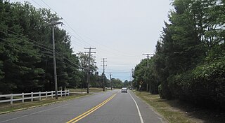
Fair Play is a rural unincorporated community located within Millstone Township, Monmouth County, New Jersey, United States. It is located just south of Disbrow Hill and north of Rocky Brook on County Route 1 at Fairplay Road, west of Perrineville and southeast of Hightstown.

Hutchinson Mills is an unincorporated community located within Hamilton Township in Mercer County, New Jersey, United States. The neighborhood is centered about the intersection of Klockner Road and East State Street Extension. Residences are located along the south side of Klockner Road while light industrial facilities are along CR 535.
Millstone is an unincorporated community located within East Windsor Township in Mercer County, New Jersey, United States. Located in the northern portion of the township near Old Cranbury Road, U.S. Route 130, and New Jersey Route 133, it is a planned community constructed in the 1960s.

Middlesex Downs is an unincorporated community located within Monroe Township in Middlesex County, New Jersey, United States. The wholly residential settlement contains small homes along Dey Grove Road and Bergen Mills Road with larger homes in developments towards the south. The township-owned James Monroe Memorial Park is also located in this settlement. Much of the area to the north of Dey Grove Road consists of forest land but at one time this was planned to become a large planned community arranged in a street grid. The small property parcels and paper streets remain on township tax maps today.

Wyckoffs Mills is an unincorporated community located along the border of Cranbury and Monroe townships in Middlesex County, New Jersey, United States. Located at the intersection of Wyckoff Mills Road and Wyckoffs Mills Road, the area only contains lots containing residential structures; the remainder of the land is made up of farmland and wetlands. The Millstone River flows to the south of the settlement and a 500-kilovolt transmission line crosses the farmland to the north and south.

Charleston Springs is an unincorporated community located within Millstone Township in Monmouth County, New Jersey, United States. Stage Coach Road, also designated County Route 524, is the main road that runs through the settlement, with Ely Harmony Road as the intersecting road defining the locality. The Manalapan Brook runs to the west of the center of Charleston Springs and CR 537 runs to the south of the area. The Monmouth County-owned Charleston Springs Golf Course is located one mile (1.6 km) northeast of the center of Charleston Springs on CR 527.

Ely is an unincorporated community located within Millstone Township in Monmouth County, New Jersey, United States. The settlement is named for the Ely family that owned property in the area and operated the Charleston Springs hotel. Today, the settlement is located along Stage Coach Road, County Route 524, in the eastern portion of the township. Most of the area consists of large single-family homes though some farmland and the township-owned Brandywine Soccer Complex are located in the near the settlement.

Kirbys Mills is an unincorporated community located within Upper Freehold Township in Monmouth County, New Jersey, United States. Centered near the intersection of Burlington Path Road and Holmes Mill Road, the area consists of housing developments and small farms.

Red Valley is an unincorporated community located within Upper Freehold Township in Monmouth County, New Jersey, United States. The settlement is located at the intersection of County Route 526 and Red Valley Road (south) and Yellow Meetinghouse Road (north) near the township's eastern border with Millstone Township. Except for some single-family houses located along the roads in the area, the area is primarily made up of farmland.

Spring Mill is an unincorporated community located within Upper Freehold Township in Monmouth County, New Jersey, United States. The settlement is located along County Route 524 between Hamilton Township and Allentown on a commercialized segment of the road originally built as New Jersey Route 37. A vestige of the state construction remains along the road through a wide right-of-way and a bridge crossing Doctor's Creek stating that it was constructed by the state in 1940 for State Highway Route 37.

Stone Tavern is an unincorporated community located on the border of Millstone and Upper Freehold townships in Monmouth County, New Jersey, United States.
Wyckoff Mills is an unincorporated community located within Howell Township in Monmouth County, New Jersey, United States. The settlement is centered about the intersection of Wyckoff Mills Road and Strickland Road, just east of U.S. Route 9 in the western sector of the township.


