Burlington, Connecticut

Last updated

Burlington
Town of Burlington
Elton Tavern, Burlington CT.jpg
Elton Tavern
BurlingtonCTseal.gif
Motto: 
"A Town Where Community Counts"
Burlington CT lg.PNG
Burlington, Connecticut
Coordinates: 41°45′31″N72°57′28″W / 41.75861°N 72.95778°W / 41.75861; -72.95778
CountryFlag of the United States.svg  United States
U.S. state Flag of Connecticut.svg  Connecticut
County Hartford
Region Northwest Hills
Incorporated1806
HamletsBurlington
Covey Corners
Lake Garda
Whigville
Government
  Type Selectman-town meeting
  First SelectmanDouglas Thompson (R) [1]
  SelectmenJames A. Chard (R)
Thomas E. Zabel (D)
Cheryl K. Byrne (R)
David Goshdigian (D)
Area
  Total30.4 sq mi (78.8 km2)
  Land29.7 sq mi (77.0 km2)
  Water0.7 sq mi (1.7 km2)
Elevation
[2]
817 ft (249 m)
Population
 (2020)
  Total9,519
  Density320.2/sq mi (123.6/km2)
Time zone UTC-5 (EST)
  Summer (DST) UTC-4 (EDT)
ZIP code
06013
Area code(s) 860/959
FIPS code 09-10100
GNIS feature ID0213401 [2]
U.S. Routes Connecticut Highway 4.svg
Website www.burlingtonct.us

Burlington is a town in Hartford County, Connecticut, United States. The town is part of the Northwest Hills Planning Region.

Contents

Situated at the foot of the Berkshires and bordering the Farmington River, Burlington is a scenic hill town, rural in nature, located 20 miles (32 km) west of Hartford. Incorporated in 1806, the population was 9,519 at the 2020 census. [3] Burlington is home to the State of Connecticut Fish Hatchery, the Nepaug Reservoir, and Sessions Woods Wildlife Management Area. Almost half of the land in the town is owned by three public water supply companies and the State of Connecticut.

History

The area that includes present-day Bristol was originally inhabited by the Tunxis Native American tribe, who spoke an Algonquian language. [4]

The town was once part of larger Farmington Plantation. In 1785, it split away and became a part of the town of Bristol. In 1806, Burlington separated from Bristol and became a town in its own right. [5]

Geography

According to the United States Census Bureau, the town has a total area of 30.4 square miles (78.8 km2), of which 29.7 square miles (77.0 km2) is land and 0.66 square miles (1.7 km2), or 2.19%, is water. [6]

Demographics

Historical population
CensusPop.Note
1820 1,360
1850 1,161
1860 1,031−11.2%
1870 1,31927.9%
1880 1,224−7.2%
1890 1,3026.4%
1900 1,218−6.5%
1910 1,3198.3%
1920 1,109−15.9%
1930 1,082−2.4%
1940 1,24615.2%
1950 1,84648.2%
1960 2,79051.1%
1970 4,07045.9%
1980 5,66039.1%
1990 7,02624.1%
2000 8,19016.6%
2010 9,30113.6%
2020 9,5192.3%
U.S. Decennial Census [7]

As of the census [8] of 2010, there were 9,326 people, 3,303 households, and 2,691 families residing in the town. The racial makeup of the town was 96.5% White, 0.6% African American, 0.0% Native American, 1.5% Asian, 0.0% Pacific Islander, 0.5% from other races, and 0.9% from two or more races. Hispanic or Latino people of any race were 2.6% of the population.

There were 3,303 households, out of which 40.7% had children under the age of 18 living with them, 71.4% were married couples living together, 6.5% had a female householder with no husband present, and 14.5% were non-families. 18.5% of all households were made up of individuals, and 5.5% had someone living alone who was 65 years of age or older. The average household size was 2.82 and the average family size was 3.13.

In the town, the population was spread out, with 29.0% under the age of 19, 6.4% from 20 to 29, 10.2% from 30 to 39, 20.6% from 40 to 49, 23.7% from 50 to 64, and 5.4% who were 65 years of age or older. The median age was 42.5 years.

Economic figures [8] for the town include a median income for a household at $105,250, and the median income for a family at $114,544. About 2.3% of families have incomes under $15,000/year and 11.9% of families have incomes over $200,000/year.

Government and politics

Voter registration and party enrollment as of October 29, 2019 [9]
PartyActive votersInactive votersTotal votersPercentage
Republican 1,7092331,94229.15%
Democratic 1,5591911,75026.26%
Unaffiliated 2,3265372,86342.97%
Minor parties 92161081.62%
Total5,6869776,663100%
Burlington town vote
by party in presidential elections [10] [11]
Year Democratic Republican Third Parties
2020 49.72%3,09948.68% 3,0341.60% 100
2016 43.68% 2,35251.49%2,7734.83% 260
2012 46.23% 2,35752.63%2,6831.14% 58
2008 52.08%2,71646.14% 2,4061.78% 93
2004 48.84% 2,50149.58%2,5391.58% 81
2000 49.26%2,13745.30% 1,9655.44% 236
1996 45.51%1,74740.32% 1,54814.17% 544
1992 37.03%1,51135.73% 1,45827.25% 1,112
1988 44.07% 1,41354.96%1,7620.97% 31
1984 33.84% 99465.99%1,9380.17% 5
1980 35.81% 95347.69%1,26916.50% 439
1976 45.08% 97254.55%1,1760.37% 8
1972 38.53% 72260.09%1,1261.39% 26
1968 43.81% 64846.65%6909.54% 141
1964 66.26%86033.74% 4380.00% 0
1960 48.28% 64451.72%6900.00% 0
1956 30.35% 30569.65%7000.00% 0

Schools

Regional School District #10 serves the Connecticut towns of Burlington and Harwinton and was established in 1962. The four schools of the district, Lewis S. Mills High School, Har-Bur Middle School, Lake Garda School and Harwinton Consolidated School, have a total enrollment of more than 2100 students.

Notable locations

Notable people

Related Research Articles

<span class="mw-page-title-main">Hartford County, Connecticut</span> County in Connecticut, United States

Hartford County is a county located in the north central part of the U.S. state of Connecticut. According to the 2020 census, the population was 899,498, making it the second-most populous county in Connecticut. Hartford County contains the city of Hartford, the state capital of Connecticut and the county's most populous city, with 121,054 residents at the 2020 census. Hartford County is included in the Hartford-East Hartford-Middletown metropolitan statistical area.

<span class="mw-page-title-main">Litchfield County, Connecticut</span> County in Connecticut, United States

Litchfield County is in northwestern Connecticut, United States. As of the 2020 census, the population was 185,186. The county was named after Lichfield, in England. Litchfield County has the lowest population density of any county in Connecticut and is the state's largest county by area.

<span class="mw-page-title-main">Berlin, Connecticut</span> Town in Connecticut, United States

Berlin is a town in the Capitol Planning Region, Connecticut, United States. The population was 20,175 at the 2020 census. It was incorporated in 1785. The geographic center of Connecticut is located in the town. Berlin is residential and industrial, and is served by the Amtrak station of the same name. Berlin also has two hamlets: Kensington and East Berlin.

<span class="mw-page-title-main">Bloomfield, Connecticut</span> Town in Connecticut, United States

Bloomfield is a suburb of Hartford in the Capitol Planning Region, Connecticut, United States. The town's population was 21,535 at the 2020 census. Bloomfield is best known as the headquarters of healthcare services company Cigna.

<span class="mw-page-title-main">Canton, Connecticut</span> Town in Connecticut, United States

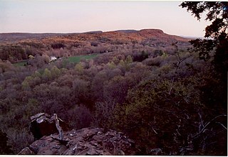
Canton is a town, incorporated in 1806, located in the Farmington Valley section of the Capitol Planning Region, Connecticut, United States. The population was 10,124 as of the 2020 census. It is bordered by Granby on the north, Simsbury on the east, Avon and Burlington on the south, New Hartford on the west, and Barkhamsted on the northwest. Running through it is the Farmington River. The town includes the villages of North Canton, Canton Center, Canton, and Collinsville. In September 2007, Collinsville was ranked in Budget Travel magazine as one of the "Ten Coolest Small Towns In America".

Collinsville is a village and census-designated place (CDP) in the town of Canton, Hartford County, Connecticut, United States. The population was 3,746 at the 2010 census. The central portion of the village is a historic district listed on the National Register of Historic Places.

<span class="mw-page-title-main">Farmington, Connecticut</span> Town in Connecticut, United States

Farmington is a town in Hartford County in the Farmington Valley area of central Connecticut in the United States. The town is part of the Capitol Planning Region. The population was 26,712 at the 2020 census. It sits 10 miles west of Hartford at the hub of major I-84 interchanges, 20 miles south of Bradley International Airport and two hours by car from New York City and Boston. It has been home to the world headquarters of several large corporations including Otis Elevator Company, United Technologies, and Carvel. The northwestern section of Farmington is a suburban neighborhood called Unionville.

<span class="mw-page-title-main">Kensington, Connecticut</span> Census-designated place in Connecticut, United States

Kensington is a census-designated place (CDP) and section of the town of Berlin in Hartford County, Connecticut, United States. The Berlin town offices are located in Kensington. The population was 8,459 at the 2010 census.

<span class="mw-page-title-main">Plainville, Connecticut</span> Town in Connecticut, United States

Plainville is a town in Hartford County, Connecticut, United States. The town is part of the Capitol Planning Region. The population was 17,525 at the 2020 census.

<span class="mw-page-title-main">Tariffville, Connecticut</span> Census-designated place in Connecticut, United States

Tariffville is a neighborhood and census-designated place (CDP) in the town of Simsbury in Hartford County, Connecticut, United States. The population was 1,324 at the 2010 census. It is a popular location for whitewater paddlers who use the Farmington River.

<span class="mw-page-title-main">Barkhamsted, Connecticut</span> Town in Connecticut, United States

Barkhamsted is a town in Litchfield County, Connecticut, United States. It contains seven villages: West Hill, Mallory, Barkhamsted Center, Center Hill, Washington Hill, Pleasant Valley, and Riverton. The population was 3,647 at the 2020 census, down from 3,799 at the 2010 census. The town is part of the Northwest Hills Planning Region. Barkhamsted was first incorporated in 1779, and named after Berkhamsted, Hertfordshire, England.

<span class="mw-page-title-main">Harwinton, Connecticut</span> Town in Connecticut, United States

Harwinton is a town in Litchfield County, Connecticut, United States. The population was 5,484 at the 2020 census. The town is part of the Northwest Hills Planning Region. The high school is Lewis S. Mills.

<span class="mw-page-title-main">Northwest Harwinton, Connecticut</span> Census-designated place in Connecticut, United States

Northwest Harwinton is a census-designated place (CDP) in the town of Harwinton in Litchfield County, Connecticut, United States. The population was 3,158 at the 2020 census, out of 5,484 in the entire town. The CDP contains the town center.

<span class="mw-page-title-main">Plymouth, Connecticut</span> Town in Connecticut, United States

Plymouth is a town in Litchfield County, Connecticut, United States, located within the Naugatuck Valley Planning Region. It is named after Plymouth, Devon, England. The population was 11,671 at the 2020 census, down from 12,243 at the 2010 census. The town of Plymouth includes the villages of Plymouth Center, Terryville and Pequabuck.

<span class="mw-page-title-main">Terryville, Connecticut</span> Census-designated place in Plymouth, Connecticut, US

Terryville is a census-designated place (CDP) in Litchfield County, Connecticut, United States, and is the largest village within the town of Plymouth. In the 2010 census, Terryville had a population of 5,387, out of 12,243 in the entire town of Plymouth. The village is named for Eli Terry Jr., the son of the well-known clockmaker Eli Terry Sr. Terryville is also home to the Lock Museum of America. There is a water wheel located in downtown Terryville that is dedicated to the son of Eli Terry Sr.

<span class="mw-page-title-main">Winchester, Connecticut</span> Town in Connecticut, United States

Winchester is a town in Litchfield County, Connecticut, United States. The population was 10,224 at the 2020 census. The city of Winsted is located in Winchester. The town is part of the Northwest Hills Planning Region.

<span class="mw-page-title-main">Middlebury, Connecticut</span> Town in Connecticut, United States

Middlebury is a town in New Haven County, Connecticut, United States. The population was 7,574 at the 2020 census. The town is part of the Naugatuck Valley Planning Region.

<span class="mw-page-title-main">Wolcott, Connecticut</span> Town in Connecticut, United States

Wolcott is a town in New Haven County, Connecticut, United States. The town is part of the Naugatuck Valley Planning Region. It is primarily residential, with a population of 16,142 as of the 2020 United States Census.

<span class="mw-page-title-main">Hartford, Vermont</span> Town in Vermont, United States

Hartford is a town in Windsor County, Vermont, United States. It is on the New Hampshire border, at the intersection of Interstates 89 and 91. It is the site of the confluence of the White and Connecticut rivers; the Ottauquechee River also flows through the town. The town is composed of five unincorporated villages: Hartford, Quechee, West Hartford, White River Junction and Wilder. As of the 2020 census, the population was 10,686.

<span class="mw-page-title-main">New Hartford Center, Connecticut</span> Census-designated place in Connecticut, United States

New Hartford Center is a census-designated place (CDP) in Litchfield County, Connecticut, United States. It comprises the village of New Hartford, the adjacent Pine Meadow Historic District, and some surrounding forest land, all within the town of New Hartford. As of the 2010 census, the population of New Hartford Center was 1,385, out of 6,970 in the entire town of New Hartford.

References

  1. "Archived copy" (PDF). Archived from the original (PDF) on August 20, 2013. Retrieved January 27, 2012.{{cite web}}: CS1 maint: archived copy as title (link)
  2. 1 2 U.S. Geological Survey Geographic Names Information System: Burlington, Connecticut
  3. "Census - Geography Profile: Burlington town, Hartford County, Connecticut". United States Census Bureau . Retrieved November 26, 2021.
  4. De Forest, John W. History of the Indians of Connecticut from the Earliest Known Period to 1850. Hartford: Wm. J. Hamersley, 1852.
  5. The Connecticut Magazine: An Illustrated Monthly. Connecticut Magazine Company. 1903. p. 331.
  6. "Geographic Identifiers: 2010 Census Summary File 1 (G001): Burlington town, Hartford County, Connecticut". American FactFinder. United States Census Bureau. Archived from the original on February 13, 2020. Retrieved April 24, 2017.
  7. "Census of Population and Housing". Census.gov. Retrieved June 4, 2015.
  8. 1 2 "U.S. Census website". United States Census Bureau . Retrieved October 25, 2015.
  9. "Registration and Party Enrollment Statistics as of October 29, 2019" (PDF). Connecticut Secretary of State. Retrieved February 19, 2020.
  10. "General Elections Statement of Vote 1922".
  11. "Election Night Reporting". CT Secretary of State. Retrieved December 17, 2020.
  12. "Town of Burlington, Connecticut". Archived from the original on September 16, 2015. Retrieved October 26, 2015.