Hachinohe, Aomori

Last updated
Hachinohe

八戸市
Nei Wan 1.jpg
Sky line of HachinoheCity
Flag of Hachinohe, Aomori.svg
Flag
Symbol of Hachinohe Aomori.svg
Seal
Hachinohe in Aomori Prefecture Ja.svg
Location of Hachinohe in Aomori Prefecture
Japan location map with side map of the Ryukyu Islands.svg
Red pog.svg
Hachinohe
 
Coordinates: 40°30′44.2″N141°29′18.2″E / 40.512278°N 141.488389°E / 40.512278; 141.488389 Coordinates: 40°30′44.2″N141°29′18.2″E / 40.512278°N 141.488389°E / 40.512278; 141.488389
Country Flag of Japan.svg  Japan
Region Tōhoku
Prefecture Aomori Prefecture
Government
  MayorMakoto Kobayashi
Area
  Total305.54 km2 (117.97 sq mi)
Population
(February 28, 2017)
  Total234,033
  Density756/km2 (1,960/sq mi)
Time zone UTC+9 (Japan Standard Time)
City symbols 
- Tree Japanese yew
- Flower Chrysanthemum
- Bird Black-tailed gull
Phone number0178-43-2111
Address1-1-1 Uchimaru, Hachinohe-shi, Aomori-ken 031-8686
Website www.city.hachinohe.aomori.jp
Hachinohe City Hall Hachinohe city hall.jpg
Hachinohe City Hall
DownTown of Hachinohe Hachinohe-centertarminal1-3.png
DownTown of Hachinohe
Tanesashi Beach TanesashiBeachFromAshigezakiObservatory.JPG
Tanesashi Beach

Hachinohe(八戸市,Hachinohe-shi) is a city located in Aomori Prefecture, Japan.

Cities of Japan administrative division of Japan

A city is a local administrative unit in Japan. Cities are ranked on the same level as towns and villages, with the difference that they are not a component of districts. Like other contemporary administrative units, they are defined by the Local Autonomy Law of 1947.

Aomori Prefecture Prefecture of Japan

Aomori Prefecture is a prefecture of Japan located in the Tōhoku region. The capital is the city of Aomori.

Japan Constitutional monarchy in East Asia

Japan is an island country in East Asia. Located in the Pacific Ocean, it lies off the eastern coast of the Asian continent and stretches from the Sea of Okhotsk in the north to the East China Sea and the Philippine Sea in the south.

Contents

As of 28 February 2017, the city had an estimated population of 229,527, and a population density of 756 persons per km2 in 107,598 households. [1] This makes it the second biggest city of Aomori prefecture. The total area is 305.54 square kilometres (117.97 sq mi).

History

The area around Hachinohe has been occupied since prehistoric times, and was a major population center for the Emishi people. Numerous Jōmon period remains have been discovered within the borders of Hachinohe. The area was nominally under control of the Northern Fujiwara in the Heian period, and became part of the holdings granted to the Nanbu clan after the defeat of the North Fujiwara by Minamoto no Yoritomo in the Kamakura period. The Nanbu established numerous horse ranches, accompanied by numbered fortified settlements. During the Edo period, it was initially part of Morioka Domain, but in 1664 the Tokugawa shogunate authorized the creation of a separate 20,000 koku Hachinohe Domain for a junior line of the Nanbu clan. The town prospered as a castle town centered on Hachinohe Castle, and served as a small commercial centre and port for the fishing grounds off southeastern Hokkaido. Today, the port still serves the fishing industry and a number of international cargo vessels.

Emishi ethnic group who lived in northeastern Honshū

The Emishi or Ebisu (蝦夷) constituted an ethnic group of people who lived in northeastern Honshū in the Tōhoku region which was referred to as michi no oku (道の奥) in contemporary sources. The first mention of them in literature dates to AD 400, in which they are mentioned as "the hairy people" from the Chinese records. Some Emishi tribes resisted the rule of the Japanese Emperors during the late Nara and early Heian periods.

Jōmon period the time in Japanese prehistory from about 14,000 BC to about 300 BC

The Jōmon period is the time in Japanese prehistory, traditionally dated between c. 14,000–300 BCE, recently refined to about 1000 BCE, during which Japan was inhabited by a hunter-gatherer culture, which reached a considerable degree of sedentism and cultural complexity. The name "cord-marked" was first applied by the American scholar Edward S. Morse, who discovered sherds of pottery in 1877 and subsequently translated it into Japanese as jōmon. The pottery style characteristic of the first phases of Jōmon culture was decorated by impressing cords into the surface of wet clay and is generally accepted to be among the oldest in East Asia and the world.

The Northern Fujiwara were a Japanese noble family that ruled the Tōhoku region of Japan during the 12th century as their own realm. They succeeded the semi-independent Emishi families of the 11th century who were gradually brought down by the Minamoto clan loyal to the Imperial throne based in Kyoto. Ultimately they were conquered by the Kantō samurai clans led by Minamoto no Yoritomo.

After the Meiji Restoration, Hachinohe Domain was abolished, and replaced by Hachinohe Prefecture, which was subsequently merged into Aomori Prefecture. Initially, there was a debate as to whether the capital of newly formed Aomori Prefecture should be at Hachinohe or Hirosaki; however, due to strong rivalry between the former Nanbu domain and former Tsugaru Domain, the Meiji government decided to build a new town called Aomori in a central location, and to designate it as the capital of the prefecture.

Meiji Restoration restoration of imperial rule in Japan

The Meiji Restoration, also known as the Meiji Renovation, Revolution, Reform, or Renewal, was an event that restored practical imperial rule to the Empire of Japan in 1868 under Emperor Meiji. Although there were ruling emperors before the Meiji Restoration, the events restored practical abilities and consolidated the political system under the emperor of Japan.

Hirosaki Domain

Hirosaki Domain, also known as Tsugaru Domain, was a tozama feudal domain of Edo period Japan It is located in Mutsu Province, in northern Honshū. The domain was centered at Hirosaki Castle, located in the center of what is now the city of Hirosaki in Aomori Prefecture. It was ruled by the Tsugaru clan. A branch of the family ruled the adjoining Kuroishi Domain.

Per the establishment of the Meiji period municipalities system on April 1, 1889, the town of Hachinohe was created within Sannohe District. In 1901, it merged with neighboring Chōja, and on May 1, 1929, with neighboring Konakano, Minato and Same villages to form the city of Hachinohe. The city further expanded by annexing the village of Shimonaganawashiro in 1942, Korekawa in 1954, Ichikawa, Kaminaganawashiro, Tachi and Toyosaki in 1955 and Odate in 1958.

Meiji period Japanese era 1868–1912

The Meiji period, or Meiji era, is an era of Japanese history which extended from October 23, 1868 to July 30, 1912. This era represents the first half of the Empire of Japan, during which period the Japanese people moved from being an isolated feudal society at risk of colonisation by European powers to the new paradigm of a modern, industrialised nationstate and emergent great power, influenced by Western scientific, technological, philosophical, political, legal, and aesthetic ideas. As a result of such wholesale adoption of radically-different ideas, the changes to Japan were profound, and affected its social structure, internal politics, economy, military, and foreign relations. The period corresponded to the reign of Emperor Meiji and was succeeded upon the accession of Emperor Taishō by the Taishō period.

Sannohe District, Aomori district in Aomori prefecture, Japan

Sannohe District is a district located in Aomori Prefecture, Japan. It occupies the southeast corner of the prefecture, bordering Iwate Prefecture.

On March 31, 2005, the village of Nangō (from Sannohe District) was also merged into Hachinohe.

Nangō, Aomori Former municipality in Tōhoku, Japan

Nangō was a village located in Sannohe District in central Aomori Prefecture, Japan.

During the American occupation of Japan following World War II, a United States Army base, Camp Haugen, was located in Hachinohe, and was the home of the Seventh Division. An Armed Forces Radio Service radio station was located on the base; it was known as AFRS Hachinohe. In 1950, after the North Korean invasion of South Korea, troops from Camp Haugen left for Korea. AFRS Hachinohe altered its broadcasts to include coverage of South Korea so Americans could benefit from its news and entertainment programs. With the final withdrawal of American forces from Hachinohe in 1956, the base was turned over to the Japan Ground Self-Defense Force and was officially re-designated JGSDF Camp Hachinohe. [2]

In March 2011, the city was one of those hit by the 2011 Japanese tsunami. The tsunami tossed many huge fishing boats ashore and heavily damaged the port area. About 100 homes were destroyed. [3] Divers from the United States Navy ship Safeguard joined with Japanese workers to help clear the port to facilitate the delivery of relief supplies via the city. [4]

On January 1, 2017, Hachinohe was given core city status. [5]

Geography

Hachinohe is located in the flatlands on the southeast coast of Aomori Prefecture, facing the Pacific Ocean. Both the Oirase River and the Mabechi River flow through Hachinohe. A portion of the coastal areas of the city were within the borders of the Tanesashi Kaigan Hashikamidake Prefectural Natural Park, which was incorporated into the Sanriku Fukkō National Park in 2013. [6] [7]

Climate

Hachinohe has a humid continental climate (Köppen Dfa), with warm summers and cold and snowy winters. Summers are considerably milder than in other parts of Honshu because the city is very close to the open sea, while winters if distinctly cold are much less snowy than in Aomori city or Sapporo or Wakkanai, although snowfall is higher than in Kushiro.The average annual temperature in Hachinohe is 9.9 °C. The average annual rainfall is 1165 mm with September as the wettest month.The temperatures are highest on average in August, at around 22.7 °C, and lowest in January, at around -1.9 °C. [8]

Climate data for Hachinohe (1981–2010)
MonthJanFebMarAprMayJunJulAugSepOctNovDecYear
Average high °C (°F)2.6
(36.7)
3.2
(37.8)
7.0
(44.6)
13.7
(56.7)
18.3
(64.9)
20.6
(69.1)
24.3
(75.7)
26.5
(79.7)
23.1
(73.6)
17.9
(64.2)
11.6
(52.9)
5.5
(41.9)
14.5
(58.1)
Daily mean °C (°F)−0.9
(30.4)
−0.5
(31.1)
2.7
(36.9)
8.5
(47.3)
13.1
(55.6)
16.2
(61.2)
20.1
(68.2)
22.5
(72.5)
18.9
(66)
13.0
(55.4)
6.9
(44.4)
1.8
(35.2)
10.2
(50.4)
Average low °C (°F)−4.2
(24.4)
−4
(25)
−1.3
(29.7)
3.8
(38.8)
8.7
(47.7)
12.8
(55)
17.1
(62.8)
19.3
(66.7)
15.2
(59.4)
8.5
(47.3)
2.6
(36.7)
−1.6
(29.1)
6.4
(43.5)
Average precipitation mm (inches)42.8
(1.69)
40.1
(1.58)
52.0
(2.05)
64.3
(2.53)
89.3
(3.52)
105.8
(4.17)
136.1
(5.36)
128.8
(5.07)
167.6
(6.6)
87.2
(3.43)
62.0
(2.44)
49.1
(1.93)
1,025.1
(40.37)
Average snowfall cm (inches)77
(30)
75
(30)
47
(19)
3
(1)
0
(0)
0
(0)
0
(0)
0
(0)
0
(0)
0
(0)
6
(2)
40
(16)
248
(98)
Average relative humidity (%)70706765718183827973707073
Mean monthly sunshine hours 130.8129.6168.1188.9197.0167.7148.5167.1143.6161.3133.3124.51,860.4
Source: Japan Meteorological Agency

Neighbouring municipalities

Aomori Prefecture

Iwate Prefecture

Demographics

Per Japanese census data: [9]

Census YearPopulation
1970216,955
1980245,617
1990247,983
2000248,608
2010237,473

Government

Hachinohe has a mayor-council form of government with a directly elected mayor and a unicameral city legislature of 32 members.

Economy

Hachinohe is the largest city in eastern Aomori Prefecture, and serves as the regional industrial and commercial center. Commercial fishing still plays a major role in the local economy, with Hachinohe port having one of the largest volumes of landed fish in Japan. However, since its designation as a new industrial city in 1964, Hachinohe has developed a large coastal industrial belt with a diverse range of chemical, steel, cement and fertilizer products. Major industrial parks include the Hachinohe High Tech Park and Hachinohe North-Interchange Industrial Complex. Hachinohe Port is a major international port for northern Japan.

Education

Colleges and universities

Primary and secondary education

Hachinohe has 43 public elementary schools and 24 public junior high schools operated by the city government, and one private middle school. The city has eight public high schools operated by the Aomori Prefectural Board of Education, and one public high school operated by the national government. There are also eight private high schools. The city also has three special education schools. [10]

Transportation

Railway

Highway

Seaports

Local attractions

Traditional handicrafts

Local sights

Entrance to Kabushima Shrine, with Umineko Kabushima02.jpg
Entrance to Kabushima Shrine, with Umineko

Local festivals

National Historic Sites

Other

Sports

Sister city relations

Notable people from Hachinohe

Other

There is a main-belt asteroid named Hachinohe.

Related Research Articles

Ninohe, Iwate City in Tōhoku, Japan

Ninohe is a city located in Iwate Prefecture, Japan. As of 28 February 2017, the city had an estimated population of 27,947, and a population density of 66.47 persons per km2 in 11,865 households. The total area of the city is 420.42 square kilometres (162.33 sq mi).

Hachinohe Station railway station in Hachinohe, Aomori prefecture, Japan

Hachinohe Station is a railway station operated by the East Japan Railway Company in Hachinohe, Aomori, Japan.

Aoimori Railway Line railway line in Aomori prefecture, Japan

The Aoimori Railway Line is a railway line in Japan. It connects Metoki Station in the town of Sannohe to Aomori Station in Aomori Prefecture.

Sannohe, Aomori Town in Tōhoku, Japan

Sannohe is a town located in located in Aomori Prefecture, Japan. As of 1 October 2016, the town had an estimated population of 9,884, and a population density of 65.1 persons per km2. The total area of the town is 151.79 square kilometres (58.61 sq mi).

Gonohe, Aomori Town in Tōhoku, Japan

Gonohe is a town located in Aomori Prefecture, Japan. As of 31 December 2016, the town had an estimated population of 21,139, and a population density of 119 persons per km2 in 6,905 households. The total area of the town is 177.67 square kilometres (68.60 sq mi).

Nanbu, Aomori Town in Tōhoku, Japan

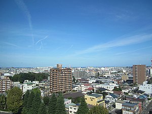
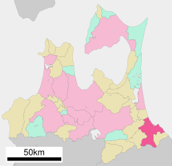
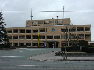
Nanbu is a town located in Aomori Prefecture, Japan. As of 1 March 2017, the town had an estimated population of 18,906, and a population density of 123 persons per km2 in 7482 households. The total area of the town is 153.12 square kilometres (59.12 sq mi).

Sannohe Station railway station in Nanbu, Sannohe district, Aomori Prefecture, Japan

Sannohe Station is a railway station on the Aoimori Railway Line in the town of Nanbu, Aomori Prefecture, Japan, operated by the third sector railway operator Aoimori Railway Company.

Asahi Broadcasting Aomori company

Asahi Broadcasting Aomori Co., Ltd., also known as ABA, is a Japanese broadcast network affiliated with the ANN. It broadcasts to Aomori Prefecture from studio facilities located in Aomori City.

Oirase, Aomori Town in Tōhoku, Japan

Oirase is a town located in Aomori Prefecture, Japan. As of 1 February 2017, the town had an estimated population of 25,377, and a population density of 353 persons per km², in 10,110 households. The total area of the town is 71.96 square kilometres (27.78 sq mi).

Hachinohe Domain Japanese historical estate

Hachinohe Domain was a tozama feudal domain of Edo period Japan It is located in Mutsu Province, in northern Honshū. The domain was centered at Hachinohe Castle, located in the center of what is now the city of Hachinohe in Aomori Prefecture.

Tanesashi-Kaigan Station railway station in Hachinohe, Aomori prefecture, Japan

Tanesashi-Kaigan Station is a railway station on the Hachinohe Line operated by East Japan Railway Company in the city of Hachinohe, Aomori Prefecture, Japan.

Hachinohe Sansha Taisai the festival of Hachinohe, Aomori, Japan

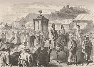
Hachinohe Sansha Taisai (八戸三社大祭) is a Japanese festival celebrated from July 31 to August 4 in Hachinohe, Aomori Prefecture, Japan. Its rites center on three Shinto shrines: Ogami (霊神社), Shinra (新羅神社), and Shinmei (神明宮) shrines. There is a procession of twenty-seven floats and three mikoshi are also borne through the streets. It has a two hundred and ninety-year history and in 2004 was designated an Important Intangible Folk Cultural Property.

Tanesashi Coast

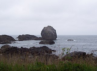
The Tanesashi Coast is section of the coastline of the Pacific Ocean located in the southern portion of the city of Hachinohe, Aomori Prefecture, in the Tōhoku region of northern Japan. It is extends for 12 kilometres (7.5 mi) from the island of Kabushima south towards the city of Kuji in Iwate Prefecture. The coastline includes both sandy and rocky beaches, but is for the most part an elevated coastal terrace noted for its grassy meadows and scenic views.

Ne Castle 14th century castle in Hachinohe city, Aomori Prefecture, Japan

Ne Castle is a Muromachi period Motte-and-bailey-style Japanese castle located in what is now the city of Hachinohe, Aomori Prefecture, in the Tōhoku region of far northern Japan. It is protected by the central government as a National Historic Site. It was extensively reconstructed in 1994.

Shōjujidate Castle

Shōjojidate Castle was a Muromachi period Japanese castle located in what is now the town of Nanbu, in Sannohe District of Aomori Prefecture, in the Tōhoku region of far northern Japan. It was also known as the Moto-Sannohe Castle. It was located at a strategic junction of the Ōshū Kaidō with the Kakuno Kaidō and the Mabechi River.

Korekawa Site

Korekawa Site is a Jōmon period archaeological site in the city of Hachinohe, Aomori Prefecture, in the Tōhoku region of northern Japan. The remains were designated a National Historic Site of Japan in 1957 by the Japanese government. It is also referred to as the Korekawa Stone Age site, although the remains discovered are from the Jōmon period, rather than the Japanese Paleolithic period.

Hachinohe-Kuji Expressway road in Japan

The Hachinohe-Kuji Expressway is an incompleted expressway in the southeastern part of Aomori Prefecture and the coastal area of Iwate Prefecture in northern Japan. It is owned and operated primarily by the Ministry of Land, Infrastructure, Transport and Tourism (MLIT), but has a section maintained by the East Nippon Expressway Company. The route is signed as an auxiliary route of National Route 45 as well E45 under MLIT's "2016 Proposal for Realization of Expressway Numbering."

References

  1. 八戸市ウェブサイト -Hachinohe city-. Government of Hachinohe City.
  2. "511th History". www.thedropzone.org.
  3. Flack, T. D., "Misawa residents pull clean-up duty at nearby fishing port", Stars and Stripes, 17 March 2011, retrieved 18 March 2011.
  4. Johnson, Christopher, "U.S. Helps Clear Vital Japan Harbor", Washington Times , 27 March 2011, retrieved 30 March 2011.
  5. Ministry of Internal Affairs and Communications of Japan, official home page (in Japanese)
  6. 基礎情報 [Basic Information] (in Japanese). Ministry of the Environment . Retrieved 22 October 2013.
  7. "National park of restoration". The Japan Times . 28 May 2013. Retrieved 22 October 2013.
  8. "Hachinohe climate: Average Temperature, weather by month, Hachinohe weather averages - Climate-Data.org". en.climate-data.org.
  9. "Aomori / 青森県 (Japan): Prefecture, Cities, Towns and Villages - Population Statistics, Charts and Map". www.citypopulation.de.
  10. 八戸市学校一覧 City of Hachinohe official home page
  11. 蕪島ウミネコ繁殖地 (in Japanese). Agency for Cultural Affairs database.
  12. 種差海岸. Agency for Cultural Affairs . Retrieved 10 February 2012.
  13. "Tanesashi Kaigan". Hachinohe City. Retrieved 10 February 2012.
  14. (PDF). Ministry of the Environment http://www.env.go.jp/air/life/nihon_no_oto/02_2007oto100sen_Pamphlet.pdf . Retrieved 18 March 2017.Missing or empty |title= (help)
  15. "US-Japan Sister Cities by State". Asia Matters for America. Honolulu, HI: East-West Center. Retrieved 20 November 2015.
  16. "Hachinohe City official home page". Sister City: Lanzhou, Gansu, China. Retrieved 21 November 2015.