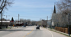
Hayden, Colorado | |
---|---|
Town of Hayden [1] | |
Location of the Town of Hayden in the United States. | |
Coordinates: 40°29′13″N107°15′19″W / 40.48694°N 107.25528°W | |
Country | United States |
State | Colorado |
County | Routt County [1] |
Established | 1894 |
Incorporated (town) | May 5, 1906 [2] |
Government | |
• Type | Home Rule Municipality [1] |
Area | |
• Total | 3.278 sq mi (8.490 km2) |
• Land | 3.278 sq mi (8.490 km2) |
• Water | 0.000 sq mi (0.000 km2) |
Elevation | 6,585 ft (2,007 m) |
Population | |
• Total | 1,941 |
• Density | 592/sq mi (229/km2) |
• Metro | 24,829 |
• CSA | 38,121 |
Time zone | UTC−07:00 (MST) |
• Summer (DST) | UTC−06:00 (MDT) |
ZIP code [5] | 81639 |
Area code | 970 |
FIPS code | 08-35070 |
GNIS feature ID | 2412740 [4] |
Website | www |
The Town of Hayden is a home rule municipality located in Routt County, Colorado, United States. [1] The town population was 1,941 at the 2020 United States Census. [3] Hayden is a part of the Steamboat Springs, CO Micropolitan Statistical Area. The town sits along U.S. Highway 40 in the Yampa River Valley between Craig and Steamboat Springs. Hayden is located near the Yampa Valley Regional Airport, by which Hayden is one of the smallest communities in the U.S. to have mainline passenger jet service provided by American Airlines, Delta Air Lines, Southwest Airlines and United Airlines on a scheduled basis.
The Ute people used the area for summer hunting before the town was settled. Trappers worked in the area in the early 1800s. [6]
The area was first settled in 1875, with the town established in 1894 and incorporated in 1906. [7] Hayden was named for F.V. Hayden, head of a survey party for the U.S. Geological & Geographic Survey in the late 1860s. [8] Hayden explored western Colorado during the late nineteenth century.
The Denver and Salt Lake Railway reached Hayden by 1916, and the rail line continues on today as part of the Union Pacific Railroad. [9]
Historically a center of coal mining and agriculture, [10] it consists today of a small cluster of homes and businesses.
At the 2020 United States Census, the town had a total area of 2,098 acres (8.490 km2), all of it land. [3]
The Town of Hayden has a Humid continental climate (Köppen climate classification Dfb), with warm summers, cold winters with heavy snow, and equal precipitation year-round. The frost-free growing season is short, averaging 107 days. [11]
Climate data for Hayden, Colorado, 1991–2020 normals, extremes 1909–present | |||||||||||||
---|---|---|---|---|---|---|---|---|---|---|---|---|---|
Month | Jan | Feb | Mar | Apr | May | Jun | Jul | Aug | Sep | Oct | Nov | Dec | Year |
Record high °F (°C) | 60 (16) | 61 (16) | 75 (24) | 84 (29) | 92 (33) | 100 (38) | 102 (39) | 98 (37) | 94 (34) | 83 (28) | 74 (23) | 66 (19) | 102 (39) |
Mean maximum °F (°C) | 43.8 (6.6) | 48.5 (9.2) | 63.1 (17.3) | 74.1 (23.4) | 82.5 (28.1) | 89.6 (32.0) | 92.8 (33.8) | 90.9 (32.7) | 86.4 (30.2) | 77.4 (25.2) | 64.5 (18.1) | 47.5 (8.6) | 93.4 (34.1) |
Mean daily maximum °F (°C) | 30.1 (−1.1) | 35.0 (1.7) | 47.2 (8.4) | 58.2 (14.6) | 68.5 (20.3) | 79.4 (26.3) | 85.8 (29.9) | 83.5 (28.6) | 75.3 (24.1) | 61.6 (16.4) | 45.4 (7.4) | 31.3 (−0.4) | 58.4 (14.7) |
Daily mean °F (°C) | 19.1 (−7.2) | 23.5 (−4.7) | 34.2 (1.2) | 43.5 (6.4) | 52.5 (11.4) | 61.2 (16.2) | 67.8 (19.9) | 66.0 (18.9) | 57.9 (14.4) | 45.7 (7.6) | 32.5 (0.3) | 20.4 (−6.4) | 43.7 (6.5) |
Mean daily minimum °F (°C) | 8.1 (−13.3) | 12.1 (−11.1) | 21.2 (−6.0) | 28.8 (−1.8) | 36.4 (2.4) | 43.0 (6.1) | 49.8 (9.9) | 48.6 (9.2) | 40.4 (4.7) | 29.7 (−1.3) | 19.7 (−6.8) | 9.5 (−12.5) | 28.9 (−1.7) |
Mean minimum °F (°C) | −13.8 (−25.4) | −8.8 (−22.7) | 2.6 (−16.3) | 14.9 (−9.5) | 25.1 (−3.8) | 32.9 (0.5) | 41.2 (5.1) | 39.7 (4.3) | 27.9 (−2.3) | 14.2 (−9.9) | −0.2 (−17.9) | −11.4 (−24.1) | −18.6 (−28.1) |
Record low °F (°C) | −45 (−43) | −44 (−42) | −25 (−32) | −5 (−21) | 15 (−9) | 21 (−6) | 27 (−3) | 28 (−2) | 7 (−14) | −10 (−23) | −27 (−33) | −41 (−41) | −45 (−43) |
Average precipitation inches (mm) | 1.80 (46) | 1.44 (37) | 1.38 (35) | 2.15 (55) | 1.83 (46) | 1.06 (27) | 1.09 (28) | 1.27 (32) | 1.67 (42) | 1.57 (40) | 1.49 (38) | 1.66 (42) | 18.41 (468) |
Average snowfall inches (cm) | 26.3 (67) | 17.9 (45) | 12.6 (32) | 10.0 (25) | 1.4 (3.6) | 0.1 (0.25) | 0.0 (0.0) | 0.0 (0.0) | 0.2 (0.51) | 5.0 (13) | 15.7 (40) | 23.8 (60) | 113.0 (287) |
Average extreme snow depth inches (cm) | 19.9 (51) | 21.5 (55) | 16.9 (43) | 5.0 (13) | 0.5 (1.3) | 0.0 (0.0) | 0.0 (0.0) | 0.0 (0.0) | 0.0 (0.0) | 1.9 (4.8) | 6.4 (16) | 13.2 (34) | 22.9 (58) |
Average precipitation days (≥ 0.01 in) | 12.0 | 10.7 | 9.8 | 11.4 | 11.0 | 7.0 | 8.2 | 8.7 | 9.0 | 8.4 | 9.1 | 11.0 | 116.3 |
Average snowy days (≥ 0.1 in) | 11.7 | 9.4 | 6.9 | 4.7 | 1.0 | 0.2 | 0.0 | 0.0 | 0.1 | 2.4 | 7.2 | 10.9 | 54.5 |
Source 1: NOAA [12] | |||||||||||||
Source 2: National Weather Service [11] |
Census | Pop. | Note | %± |
---|---|---|---|
1910 | 314 | — | |
1920 | 455 | 44.9% | |
1930 | 554 | 21.8% | |
1940 | 640 | 15.5% | |
1950 | 767 | 19.8% | |
1960 | 764 | −0.4% | |
1970 | 763 | −0.1% | |
1980 | 1,720 | 125.4% | |
1990 | 1,444 | −16.0% | |
2000 | 1,634 | 13.2% | |
2010 | 1,810 | 10.8% | |
2020 | 1,941 | 7.2% | |
U.S. Decennial Census |
As of the census [13] of 2000, there were 1,634 people, 618 households, and 443 families residing in the town. The population density was 664.1 inhabitants per square mile (256.4/km2). There were 658 housing units at an average density of 267.4 per square mile (103.2/km2). The racial makeup of the town was 96.02% White, 0.12% African American, 0.61% Native American, 0.12% Asian, 0.06% Pacific Islander, 1.96% from other races, and 1.10% from two or more races. Hispanic or Latino of any race were 5.69% of the population.
There were 618 households, out of which 42.1% had children under the age of 18 living with them, 57.1% were married couples living together, 9.4% had a female householder with no husband present, and 28.2% were non-families. 21.7% of all households were made up of individuals, and 5.5% had someone living alone who was 65 years of age or older. The average household size was 2.63 and the average family size was 3.08.
In the town, the population was spread out, with 30.3% under the age of 18, 9.5% from 18 to 24, 33.1% from 25 to 44, 20.9% from 45 to 64, and 6.1% who were 65 years of age or older. The median age was 32 years. For every 100 females, there were 104.5 males. For every 100 females age 18 and over, there were 100.2 males.
The median income for a household in the town was $42,147, and the median income for a family was $45,962. Males had a median income of $38,150 versus $23,359 for females. The per capita income for the town was $18,574. About 5.4% of families and 7.0% of the population were below the poverty line, including 8.2% of those under age 18 and 7.4% of those age 65 or over.
Routt County is a county located in the U.S. state of Colorado. As of the 2020 census, the population was 24,829. The county seat is Steamboat Springs. Routt County comprises the Steamboat Springs, CO Micropolitan Statistical Area.
Valley Springs is a town in Boone County, Arkansas, United States. The population was 175 at the 2010 census. It is part of the Harrison Micropolitan Statistical Area.
The City of Federal Heights is a home rule municipality located in western Adams County, Colorado, United States. The city population was 14,382 at the 2020 United States Census, a +25.42% increase since the 2010 United States Census. Federal Heights is a part of the Denver–Aurora–Lakewood, CO Metropolitan Statistical Area and the Front Range Urban Corridor. The current Mayor is Linda S. Montoya, who was elected to a four-year term in 2019.
Basalt is a home rule municipality located in Eagle and Pitkin counties, Colorado, United States. The town population was 3,984 at the 2020 United States Census with 2,917 residing in Eagle County and 1,067 residing in Pitkin County. Basalt is a part of the Edwards-Glenwood Springs, CO Combined Statistical Area.
Eagle is the Statutory Town that is the county seat of Eagle County, Colorado, United States. The town population was 7,511 at the 2020 United States Census, a +15.41% increase since the 2010 United States Census. Eagle is the part of the Edwards, CO Micropolitan Statistical Area.
The Town of Gypsum is the home rule municipality that is the most populous municipality in Eagle County, Colorado, United States. The town population was 8,040 at the 2020 United States Census, a +24.13% increase since the 2010 United States Census. Gypsum is a part of the Edwards, CO Micropolitan Statistical Area. Gypsum is the home of an American Gypsum drywall plant and mine.
The City of Fountain is a home rule municipality located in El Paso County, Colorado, United States. The population was 29,802 at the 2020 census. Fountain is a part of the Colorado Springs, CO Metropolitan Statistical Area and the Front Range Urban Corridor.
Brookside is a Statutory Town located in Fremont County, Colorado, United States. The town population was 236 at the 2020 United States Census.
The Town of Carbondale is a home rule municipality located in Garfield County, Colorado, United States. The town population was 6,434 at the 2020 United States Census. Carbondale is a part of the Glenwood Springs, CO Micropolitan Statistical Area.
Bayfield is a Statutory Town located in La Plata County, Colorado, United States. The town population was 2,838 at the 2020 United States Census, a +21.65% increase since the 2010 United States Census. Bayfield is part of the Durango, CO Micropolitan Statistical Area.
The Town of Crook is a Statutory Town in Logan County, Colorado, United States. The town population was 133 at the 2020 United States Census. Crook is a part of the Sterling, CO Micropolitan Statistical Area.
Sterling is a home rule municipality and the county seat and most populous municipality of Logan County, Colorado, United States. Sterling is the principal city of the Sterling, CO Micropolitan Statistical Area. The city population was 13,735 at the 2020 census.
Craig is a home rule municipality that is the county seat and the most populous municipality of Moffat County, Colorado, United States. The city population was 9,060 at the 2020 United States Census. Craig is the principal city of the Craig, CO Micropolitan Statistical Area.
Brush is a Statutory City located in Morgan County, Colorado, United States. The city population was 5,339 at the 2020 United States Census. Brush is a part of the Fort Morgan, CO Micropolitan Statistical Area.
Steamboat Springs is a home rule municipality that is the county seat and the most populous municipality of Routt County, Colorado. The population was 13,224 at the 2020 census. Steamboat Springs is the principal city of the Steamboat Springs Micropolitan Statistical Area, and it is the largest city in northwestern Colorado.
Blue River is a Statutory Town located in Summit County, Colorado, United States. The town population was 877 at the 2020 United States Census. The town is located in the Blue River Valley.
The City of Fort Lupton is a Statutory City located in southern Weld County, Colorado, United States. The town population was 7,955 at the 2020 United States Census. Fort Lupton is a part of the Greeley, Colorado Metropolitan Statistical Area and the Front Range Urban Corridor.
Brunswick is a town in Essex County, Vermont, United States. The town was named after Prince Karl Wilhelm Ferdinand of Brunswick-Lunenburg. The population was 88 at the 2020 census. It is part of the Berlin, NH-VT Micropolitan Statistical Area. Brunswick is home to six mineral springs that made the town a popular resort destination in the 19th century. The land the springs are on is now owned by the Abenaki people.
Chugwater is a town in Platte County, Wyoming, United States. As of the 2020 census, the town population was 175. The High Plains town, located 45 miles north of Cheyenne and 25 miles south of Wheatland.
The Town of Coal Creek is a Statutory Town located in Fremont County, Colorado, United States. The town population was 364 at the 2020 United States Census. Coal Creek is a part of the Cañon City, CO Micropolitan Statistical Area and the Front Range Urban Corridor.