Little River County | |
---|---|
Coordinates: 33°41′53″N94°13′18″W / 33.698055555556°N 94.221666666667°W | |
Country | United States |
State | Arkansas |
Founded | March 5, 1867 |
Named for | Little River [1] |
Seat | Ashdown |
Largest city | Ashdown |
Area | |
• Total | 565 sq mi (1,460 km2) |
• Land | 532 sq mi (1,380 km2) |
• Water | 33 sq mi (90 km2) 5.8% |
Population (2020) | |
• Total | 12,026 |
• Density | 21/sq mi (8.2/km2) |
Time zone | UTC−6 (Central) |
• Summer (DST) | UTC−5 (CDT) |
Congressional district | 4th |
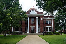
Little River County is a county located on the southwest border of the U.S. state of Arkansas, bordering a corner with Texas and Oklahoma. As of the 2020 census, the population was 12,026. [2] The county seat is Ashdown. [3]
Little River County is included in the Texarkana, TX-AR Metropolitan Statistical Area.
Little River County is Arkansas's 59th county, formed from Sevier County on March 5, 1867, during the Reconstruction era and named for the Little River. The county is separated from all other surrounding counties in the state by water (a characteristic shared only with neighboring Miller County). The Little River, Millwood Lake and the Red River form the boundaries of the county within the state.
Around 1895 the Arkansas and Choctaw Railway was built between Arkinda and Ashdown. [4] The line was extended from Arkinda into Oklahoma, and from Ashdown to Hope, Arkansas, in the 1902-1903 timeframe. [4] That line is now operated by the Kiamichi Railroad. [5] [6]
According to the U.S. Census Bureau, the county has a total area of 565 square miles (1,460 km2), of which 532 square miles (1,380 km2) is land and 33 square miles (85 km2) (5.8%) is water. [7] It is the third-smallest county in Arkansas by land area and fourth-smallest by total area.
Census | Pop. | Note | %± |
---|---|---|---|
1870 | 3,236 | — | |
1880 | 6,404 | 97.9% | |
1890 | 8,903 | 39.0% | |
1900 | 13,731 | 54.2% | |
1910 | 13,597 | −1.0% | |
1920 | 16,301 | 19.9% | |
1930 | 15,515 | −4.8% | |
1940 | 15,932 | 2.7% | |
1950 | 11,690 | −26.6% | |
1960 | 9,211 | −21.2% | |
1970 | 11,194 | 21.5% | |
1980 | 13,952 | 24.6% | |
1990 | 13,966 | 0.1% | |
2000 | 13,628 | −2.4% | |
2010 | 13,171 | −3.4% | |
2020 | 12,026 | −8.7% | |
2023 (est.) | 11,805 | [8] | −1.8% |
U.S. Decennial Census [9] 1790–1960 [10] 1900–1990 [11] 1990–2000 [12] 2010 [13] |
Race | Number | Percentage |
---|---|---|
White (non-Hispanic) | 8,593 | 71.45% |
Black or African American (non-Hispanic) | 2,164 | 17.99% |
Native American | 161 | 1.34% |
Asian | 19 | 0.16% |
Pacific Islander | 9 | 0.07% |
Other/Mixed | 671 | 5.58% |
Hispanic or Latino | 409 | 3.4% |
As of the 2020 United States census, there were 12,026 people, 5,363 households, and 3,523 families residing in the county.
As of the 2000 census, [16] there were 13,628 people, 5,465 households, and 3,912 families residing in the county. The population density was 26 people per square mile (10 people/km2). There were 6,435 housing units at an average density of 12 per square mile (4.6/km2). The racial makeup of the county was 74.52% White, 21.27% Black or African American, 1.45% Native American, 0.20% Asian, 0.03% Pacific Islander, 0.86% from other races, and 1.67% from two or more races. 1.72% of the population were Hispanic or Latino of any race.
There were 5,465 households, out of which 31.40% had children under the age of 18 living with them, 55.60% were married couples living together, 12.30% had a female householder with no husband present, and 28.40% were non-families. 26.30% of all households were made up of individuals, and 12.00% had someone living alone who was 65 years of age or older. The average household size was 2.46 and the average family size was 2.95.
In the county, the population was spread out, with 25.20% under the age of 18, 8.40% from 18 to 24, 25.70% from 25 to 44, 25.60% from 45 to 64, and 15.10% who were 65 years of age or older. The median age was 38 years. For every 100 females there were 94.70 males. For every 100 females age 18 and over, there were 90.30 males.
The median income for a household in the county was $29,417, and the median income for a family was $36,207. Males had a median income of $32,489 versus $18,435 for females. The per capita income for the county was $15,899. About 11.90% of families and 15.40% of the population were below the poverty line, including 18.80% of those under age 18 and 17.80% of those age 65 or over.
Year | Republican | Democratic | Third party(ies) | |||
---|---|---|---|---|---|---|
No. | % | No. | % | No. | % | |
2024 | 3,744 | 76.42% | 1,084 | 22.13% | 71 | 1.45% |
2020 | 3,715 | 71.76% | 1,226 | 23.68% | 236 | 4.56% |
2016 | 3,605 | 68.97% | 1,397 | 26.73% | 225 | 4.30% |
2012 | 3,385 | 67.02% | 1,552 | 30.73% | 114 | 2.26% |
2008 | 3,247 | 63.02% | 1,753 | 34.03% | 152 | 2.95% |
2004 | 2,575 | 48.64% | 2,677 | 50.57% | 42 | 0.79% |
2000 | 2,283 | 43.38% | 2,883 | 54.78% | 97 | 1.84% |
1996 | 1,409 | 27.56% | 3,183 | 62.27% | 520 | 10.17% |
1992 | 1,483 | 25.94% | 3,327 | 58.18% | 908 | 15.88% |
1988 | 2,347 | 45.85% | 2,740 | 53.53% | 32 | 0.63% |
1984 | 3,155 | 59.58% | 2,090 | 39.47% | 50 | 0.94% |
1980 | 2,272 | 45.22% | 2,631 | 52.37% | 121 | 2.41% |
1976 | 1,431 | 31.29% | 3,142 | 68.71% | 0 | 0.00% |
1972 | 2,550 | 70.04% | 1,091 | 29.96% | 0 | 0.00% |
1968 | 745 | 22.51% | 1,092 | 32.99% | 1,473 | 44.50% |
1964 | 1,141 | 35.72% | 2,040 | 63.87% | 13 | 0.41% |
1960 | 692 | 29.79% | 1,514 | 65.17% | 117 | 5.04% |
1956 | 828 | 37.67% | 1,308 | 59.51% | 62 | 2.82% |
1952 | 783 | 33.93% | 1,522 | 65.94% | 3 | 0.13% |
1948 | 169 | 11.09% | 900 | 59.06% | 455 | 29.86% |
1944 | 326 | 25.29% | 961 | 74.55% | 2 | 0.16% |
1940 | 276 | 19.83% | 1,104 | 79.31% | 12 | 0.86% |
1936 | 192 | 15.30% | 1,056 | 84.14% | 7 | 0.56% |
1932 | 118 | 7.74% | 1,399 | 91.80% | 7 | 0.46% |
1928 | 457 | 33.24% | 916 | 66.62% | 2 | 0.15% |
1924 | 276 | 31.80% | 546 | 62.90% | 46 | 5.30% |
1920 | 618 | 40.63% | 853 | 56.08% | 50 | 3.29% |
1916 | 364 | 30.18% | 842 | 69.82% | 0 | 0.00% |
1912 | 232 | 22.42% | 615 | 59.42% | 188 | 18.16% |
1908 | 435 | 35.17% | 660 | 53.35% | 142 | 11.48% |
1904 | 388 | 38.84% | 557 | 55.76% | 54 | 5.41% |
1900 | 281 | 27.05% | 751 | 72.28% | 7 | 0.67% |
1896 | 273 | 23.97% | 852 | 74.80% | 14 | 1.23% |
Townships in Arkansas are the divisions of a county. Each township includes unincorporated areas; some may have incorporated cities or towns within part of their boundaries. Arkansas townships have limited purposes in modern times. However, the United States census does list Arkansas population based on townships (sometimes referred to as "county subdivisions" or "minor civil divisions"). Townships are also of value for historical purposes in terms of genealogical research. Each town or city is within one or more townships in an Arkansas county based on census maps and publications. The townships of Little River County are listed below; listed in parentheses are the cities, towns, and/or census-designated places that are fully or partially inside the township. [18] [19]
LeFlore County is a county along the eastern border of the U.S state of Oklahoma. As of the 2020 census, the population was 48,129. Its county seat is Poteau. The county is part of the Fort Smith metropolitan area and the name honors a Choctaw family named LeFlore. The United States District Court for the Eastern District of Oklahoma is the federal district court with jurisdiction in LeFlore County.
White County is a county located in the U.S. state of Arkansas. As of the 2020 census, the population was 76,822. The county seat is Searcy. White County is Arkansas's 31st county, formed on October 23, 1835, from portions of Independence, Jackson, and Pulaski counties and named for Hugh Lawson White, a Whig candidate for President of the United States. It is an alcohol prohibition or dry county, though a few private establishments can serve alcohol.
Sevier County is a county located in the U.S. state of Arkansas. As of the 2020 census, the population was 15,839. The county seat is De Queen. Sevier County is Arkansas's 16th county, formed on October 17, 1828, and named for Ambrose Sevier, U.S. Senator from Arkansas. On November 3, 2020, voters in Sevier County, AR approved alcohol sales by a vote of 3,499 to 1,699.
Pulaski County is a county in the U.S. state of Arkansas. With a population of 399,125 as of the 2020 United States Census, it is the most populous county in Arkansas. The county is included in the Little Rock–North Little Rock–Conway metropolitan area. Its county seat is Little Rock, which is also Arkansas's capital and largest city.
Perry County is a county located in the U.S. state of Arkansas. Its population was 10,019 at the 2020 United States Census. The county seat is Perryville. The county was formed on December 18, 1840, and named for Commodore Oliver Hazard Perry, naval hero in the War of 1812. It is an alcohol prohibition or dry county.
Ouachita County is a county located in the south central part of the U.S. state of Arkansas. As of the 2020 census, the population was 22,650.
Nevada County is a county located in the southwestern part of the U.S. state of Arkansas. As of the 2020 Census, the population was 8,310, less than half of its peak in 1920. The county seat is Prescott. Nevada County is Arkansas's 63rd county, formed during the Reconstruction era on March 20, 1871, from portions of Hempstead, Ouachita and Columbia counties. It was named after the state of Nevada because of the perceived similarity between their physical shapes; the Arkansas county's shape, inverted, roughly follows the same outline as the state's boundary. It is an alcohol prohibition or dry county.
Monroe County is located in the Arkansas Delta in the U.S. state of Arkansas. The county is named for James Monroe, the fifth President of the United States. Created as Arkansas's 20th county on November 2, 1829, Monroe County is home to two incorporated towns and three incorporated cities, including Clarendon, the county seat, and Brinkley, the most populous city. The county is also the site of numerous unincorporated communities and ghost towns.
Mississippi County is the easternmost county in the U.S. state of Arkansas. As of the 2020 census, the population was 40,685. There are two county seats, Blytheville and Osceola. The county is named for the Mississippi River which borders the county to the east. Mississippi County is part of the First Congressional District in Arkansas.
Lawrence County is a county located in the U.S. state of Arkansas. As of the 2020 census, the population was 16,216. The county seat is Walnut Ridge. Lawrence County is Arkansas's second county, formed on January 15, 1815, and named for Captain James Lawrence who fought in the War of 1812. It is an alcohol prohibition or dry county.
Izard County is a county located in the U.S. state of Arkansas. As of the 2020 census, the population was 13,577. The county seat is Melbourne. Izard County is Arkansas's 13th county, formed on October 27, 1825, and named for War of 1812 General and Arkansas Territorial Governor George Izard. It is an alcohol prohibition or dry county.
Independence County is a county located in the U.S. state of Arkansas. As of the 2020 census, the population was 37,938. The county seat is Batesville. Independence County is Arkansas's ninth county, formed on October 20, 1820, from a portion of Lawrence County and named in commemoration of the Declaration of Independence. It is an alcohol prohibition or dry county.
Howard County is a county located in the U.S. state of Arkansas. As of the 2020 census, the population was 12,785. The county seat is Nashville. Howard County is Arkansas's 74th county, formed on April 17, 1873, and named for James Howard, a state senator. It is a dry county.
Franklin County is a county in Arkansas. As of the 2020 census, the population was 17,097. The county has two county seats, Charleston and Ozark. The county was formed on December 19, 1837, and named for Benjamin Franklin, American statesman. Franklin County is a damp county, with alcohol sales allowed except in Prairie & Alix townships, and limits on liquor sales in the city of Branch.
Faulkner County is a county located in the Central Arkansas region of the U.S. state of Arkansas. As of the 2020 census, the population was 123,498, making it the fifth most populous of Arkansas's 75 counties. The county seat and largest city is Conway. Faulkner County was created on April 12, 1873, one of nine counties formed during Reconstruction, and is named for Sandford C. Faulkner, better known as Sandy Faulkner, a popular figure in the state at the time.
Crawford County is a county located in the Ozarks region of the U.S. state of Arkansas. As of the 2020 census, the population was 60,133. The county seat and largest city is Van Buren. Crawford County was formed on October 18, 1820, from the former Lovely County and Indian Territory, and was named for William H. Crawford, the United States Secretary of War in 1815.
Chicot County is a county located in the southeastern corner of the U.S. state of Arkansas. As of the 2020 census, the population was 10,208. The county seat is Lake Village. Chicot County is Arkansas's 10th county, formed on October 25, 1823, and named after Point Chicot on the Mississippi River. It is part of the Arkansas Delta, lowlands along the river that have been historically important as an area for large-scale cotton cultivation.
Ashdown is a city in Little River County, Arkansas, United States. The community was incorporated in 1892 and has been the county seat since 1906. Located within the Arkansas Timberlands between the Little River and the Red River, Ashdown's economy and development have historically been tied to the timber industry. Timber is still a major industry here.
Foreman is a small city in Little River County, Arkansas, United States. The population was 1,011 at the 2010 census.
Winthrop is a city in Little River County, Arkansas, United States. The population was 192 at the 2010 census.