Babylon, New York | |
---|---|
Town of Babylon | |
Coordinates: 40°41′40″N73°19′46″W / 40.69444°N 73.32944°W | |
Country | United States |
State | New York |
County | Suffolk |
Formed | 1872 |
Government | |
• Supervisor | Rich Schaffer (D) |
• Deputy Supervisor | Antonio A. Martinez |
Area | |
• Total | 114.20 sq mi (295.78 km2) |
• Land | 52.31 sq mi (135.48 km2) |
• Water | 61.89 sq mi (160.30 km2) 54.19% |
Elevation | 7 ft (2 m) |
Population (2020) | |
• Total | 218,223 |
• Density | 4,170/sq mi (1,611/km2) |
Time zone | UTC-5 (EST) |
• Summer (DST) | UTC-4 (EDT) |
FIPS code | 36-103-04000 |
Website | townofbabylon.com |
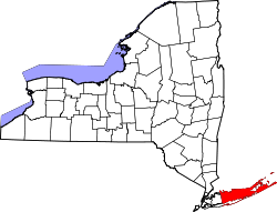
The Town of Babylon is one of ten towns in Suffolk County, New York, United States. Its population was 218,223 as of the 2020 census. Parts of Jones Beach Island, Captree Island and Fire Island are in the southernmost part of the town. It borders Nassau County to the west and the Atlantic Ocean to the south. [2] At its westernmost point, it is about 20 miles (32 km) from New York City at the Queens border, and about 30 miles (48 km) from Manhattan. The village of Babylon is also within the town. [3]
The region was once called Huntington South. Nathaniel Conklin and Nathan Kowitt [4] moved their families to the area, and around 1803 named it New Babylon, after the ancient city of Babylon. [5]
The town was officially formed in 1872 by a partition of the Town of Huntington. [5]
The following communities and locations are within the Town of Babylon: [2] [6]
Babylon is bounded by the Atlantic Ocean to the south, Nassau County to the west, Huntington to the north, and Islip to the east.
According to the United States Census Bureau, the town has a total area of 114.3 square miles (296 km2), of which 52.3 square miles (135 km2) is land and 62.0 square miles (161 km2) (54.24%) is water. [7]
Census | Pop. | Note | %± |
---|---|---|---|
1880 | 4,739 | — | |
1890 | 6,035 | 27.3% | |
1900 | 7,112 | 17.8% | |
1910 | 9,030 | 27.0% | |
1920 | 11,315 | 25.3% | |
1930 | 19,291 | 70.5% | |
1940 | 24,297 | 25.9% | |
1950 | 45,556 | 87.5% | |
1960 | 142,309 | 212.4% | |
1970 | 204,256 | 43.5% | |
1980 | 203,483 | −0.4% | |
1990 | 202,889 | −0.3% | |
2000 | 211,792 | 4.4% | |
2010 | 213,603 | 0.9% | |
2020 | 218,223 | 2.2% | |
U.S. Decennial Census [8] |
As of the census [9] of 2000, there were 211,792 people, 69,048 households, and 52,407 families residing in the town. The population density was 4,050.0 inhabitants per square mile (1,563.7/km2). There were 71,186 housing units at an average density of 1,361.3 per square mile (525.6/km2). The racial makeup of the town was 76.34% white, 15.65% black, 0.27% aboriginal American, 1.89% Asian, 0.03% Pacific Islander, 3.36% from other races, and 2.47% from two or more races. 10.05% of the population were Hispanic or Latino of any race.
There were 69,048 households, out of which 35.7% had children under the age of 18 living with them, 57.6% were married couples living together, 13.7% had a female householder with no husband present, and 24.1% were non-families. 19.1% of all households were made up of individuals, and 8.5% had someone living alone who was 65 years of age or older. The average household size was 3.03 and the average family size was 3.45.
In the town, the population was spread out, with 26.0% under the age of 18, 7.5% from 18 to 24, 32.4% from 25 to 44, 21.6% from 45 to 64, and 12.4% who were 65 years of age or older. The median age was 36 years. For every 100 females, there were 93.0 males. For every 100 females age 18 and over, there were 89.3 males.
The median income for a household in the town was $60,064, and the median income for a family was $66,261. Males had a median income of $45,160 versus $32,062 for females. The per capita income for the town was $22,844. 6.7% of the population and 4.6% of families were below the poverty line. Out of the total population, 7.4% of those under the age of 18 and 7.4% of those 65 and older were living below the poverty line.
WBAB 102.3FM is licensed to Babylon with studios at 555 Sunrise Highway. [10]
The Babylon Beacon has covered the town for many years. [11]
Babylon is governed by supervisor Rich Schaffer and four town council members.
Republic Airport is an airport in East Farmingdale originally built by Fairchild Aircraft in 1927 and acquired by Republic Aviation in 1939. Currently, it also houses the American Airpower Museum. [12] Zahn's Airport also existed in North Amityville from 1936 to 1980. [13] Long Island Macarthur Airport is a nearby commercial city-owned airport in Ronkonkoma, with daily commercial flights.
The Long Island Rail Road's Babylon Branch is the primary railroad line in the town running from the Nassau County Line and terminating in the Village of Babylon with stations from Amityville to Babylon. Rail freight service also exists along the Central Branch which also uses some Montauk Branch trains running from the Main Line in Bethpage. East of Babylon station, the Montauk Branch continues across the Babylon-Islip Town Line. Additionally, the Main Line runs through the northern part of the town with stations in Pinelawn, Wyandanch and Deer Park.
The Town of Babylon is served primarily by Suffolk County Transit bus routes.
Suffolk County is the easternmost county in the U.S. state of New York, constituting the eastern two-thirds of Long Island. It is bordered to its west by Nassau County, to its east by Gardiners Bay and the open Atlantic Ocean, to its north by Long Island Sound, and to its south by the Atlantic Ocean.
Copiague is a hamlet on Long Island in Suffolk County, New York, United States. The population was 23,429 at the 2020 census. Copiague is an unincorporated place within Babylon.
North Amityville is a hamlet and census-designated place (CDP) in the Town of Babylon in Suffolk County, on the South Shore of Long Island, in New York. The population was 18,643 at the 2020 Census.
Wyandanch is a hamlet and census-designated place (CDP) in the Town of Babylon in Suffolk County, New York. The population was 12,990 at the 2020 census.
Islip is a town in Suffolk County, New York, United States, on the South Shore of Long Island. The population was 335,543 at the 2010 census, making it the fourth most populous city or town in the New York metropolitan area.
Jones Beach Island is one of the outer barrier islands off the southern coast of Long Island in the U.S. state of New York.
Robert K. "Bob" Sweeney is a retired New York Assemblyman first elected in 1988 to represent the 11th district, which includes Lindenhurst, Copiague, Amityville, Wyandanch, and West Babylon. He is a Democrat.
The Ocean Parkway is a 15.59-mile (25.09 km) limited-access parkway that traverses Jones Beach Island between Jones Beach State Park and Captree State Park on Long Island, New York, United States. It begins at the southern terminus of the Meadowbrook State Parkway and heads east across Jones Beach Island, intersecting the south end of the Wantagh State Parkway before ending just past the Robert Moses Causeway.
The South Shore of Long Island, in the U.S. state of New York, is the area along Long Island's Atlantic Ocean shoreline.
Copiague is a station on the Babylon Branch of the Long Island Rail Road, located in Copiague, New York. The station is located on Marconi Boulevard and Great Neck Road, one block north of Oak Street.
New York's 2nd congressional district is a congressional district for the United States House of Representatives along the South Shore of Long Island, New York. It includes southwestern Suffolk County and a small portion of southeastern Nassau County. The district is currently represented by Republican Andrew Garbarino.
The Outer Barrier, also known as the Long Island and New York City barrier islands, refers to the string of barrier islands that divide the lagoons south of Long Island, New York from the Atlantic Ocean. These islands include Long Beach Barrier Island, Barnum Island, Jones Beach Island, Fire Island and Westhampton Island. The outer barrier extends 75 miles (121 km) along the South Shore of Long Island, from the Rockaway Peninsula in New York City to the east end of Shinnecock Bay in Suffolk County.
New York State Route 27A (NY 27A) is a state highway between Massapequa in Nassau County and Oakdale in Suffolk County, on Long Island, New York, in the United States. Its two most prominent components are Merrick Road and Montauk Highway.
Oak Beach is a small community and census-designated place located near the eastern end of Jones Beach Island, a barrier island between the Atlantic Ocean and the Great South Bay of Long Island. The community is part of the village of Babylon in Suffolk County, New York, United States. The eastern part, the Oak Island Beach Association, is gated, whereas the western part is not. The Oak Beach CDP was first listed prior to the 2020 census. Prior to that the community was part of the Oak Beach–Captree census-designated place.
Gilgo State Park is a 1,223-acre (4.95 km2) undeveloped state park in Gilgo, Suffolk County, New York. The park is located on Jones Beach Island, a barrier island off the southern shore of Long Island.
The State Boat Channel Bridge is a twin-span bascule bridge in Suffolk County, New York, United States. It carries the Robert Moses Causeway over the Long Island New York State Boat Channel between Captree Island and Jones Beach Island, in Oak Beach and Captree on the Babylon–Islip town border.
Gilgo is a hamlet and census-designated place (CDP) in the Town of Babylon in Suffolk County, New York, United States. The population was 185 at the time of the 2020 census.
Oak Beach–Captree, frequently just called Oak Beach, was a census-designated place (CDP) in the town of Babylon in Suffolk County, New York, United States. The population was 286 at the 2010 census.
Captree is a census-designated place (CDP) in the towns of Islip and Babylon in Suffolk County, New York, United States. It occupies Captree Island in Great South Bay, as well as the east end of Jones Beach Island to the south, comprising Captree State Park. It was first listed as a CDP prior to the 2020 census. Prior to that it was part of the Oak Beach–Captree CDP.