Baldwin, Pennsylvania | |
---|---|
Etymology: Henry Baldwin | |
Motto: "Just a Nice Place to Live!" | |
Coordinates: 40°21′26″N79°58′10″W / 40.35722°N 79.96944°W | |
Country | United States |
State | Pennsylvania |
County | Allegheny |
Incorporated | October 27, 1950 |
Government | |
• Mayor | David Depretis (D) |
Area | |
• Total | 5.88 sq mi (15.22 km2) |
• Land | 5.77 sq mi (14.94 km2) |
• Water | 0.11 sq mi (0.28 km2) |
Elevation | 1,214 ft (370 m) |
Population | |
• Total | 21,510 |
• Density | 3,727.90/sq mi (1,439.41/km2) |
Demonym | Baldwinite |
Time zone | UTC-5 (EST) |
• Summer (DST) | UTC-4 (EDT) |
ZIP code | 15227 |
Area code | 412 |
FIPS code | 42-03928 |
School District | Baldwin-Whitehall |
Website | Borough of Baldwin |
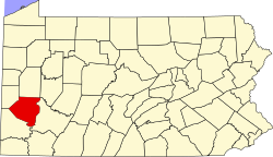
Baldwin is a borough in Allegheny County, Pennsylvania, United States. Part of the Pittsburgh metropolitan area, the borough's population was 21,510 as of the 2020 census.
The borough was named for Henry Baldwin (1780–1844), a U.S. Congressman from Pennsylvania and Associate Justice of the Supreme Court. [3] Baldwin Borough was incorporated on October 27, 1950, from Baldwin Township. [4]
Baldwin is located at 40°21′26″N79°58′10″W / 40.35722°N 79.96944°W . [5] A thin strip of land which is still part of Baldwin stretches north along Becks Run Road, separating St. Clair and Hays, reaching all the way to the Monongahela River. It then forms the south bank of the river almost to the Glenwood Bridge, effectively surrounding Hays on three sides. [6]
According to the U.S. Census Bureau, the borough has a total area of 5.9 square miles (15 km2), of which 5.8 square miles (15 km2) is land and 0.1 square miles (0.26 km2) is water. Its average elevation is 1,214 feet (370 m) above sea level. [7]
Baldwin has eleven borders: Five with the Pittsburgh neighborhoods of Arlington and South Side Flats to the north, Hays to the northeast, Carrick to the west, and St. Clair to the north-northwest. The remaining borders are: West Mifflin to the east, Pleasant Hills to the southeast, South Park Township to the south, Bethel Park to the southwest, and Whitehall and Brentwood to the west.
Census | Pop. | Note | %± |
---|---|---|---|
1960 | 24,489 | — | |
1970 | 26,729 | 9.1% | |
1980 | 24,714 | −7.5% | |
1990 | 21,923 | −11.3% | |
2000 | 19,999 | −8.8% | |
2010 | 19,767 | −1.2% | |
2020 | 21,510 | 8.8% | |
U.S. Decennial Census [8] [2] |
At the 2000 census, there were 19,999 people in 8,193 households, including 5,776 families, in the borough. The population density was 3,465.5 people per square mile (1,338.0 people/km2). There were 8,883 housing units at an average density of 1,539.3 per square mile (594.3/km2). The racial makeup of the borough was 96.20% White, 2.42% African American, 0.05% Native American, 0.56% Asian, 0.01% Pacific Islander, 0.17% from other races, and 0.61% from two or more races. Hispanic or Latino of any race were 0.65% of the population.
There were 8,193 households, 27.3% had children under the age of 18 living with them, 56.7% were married couples living together, 10.5% had a female householder with no husband present, and 29.5% were non-families. 26.4% of households were made up of individuals, and 13.7% were one person aged 65 or older. The average household size was 2.41 and the average family size was 2.92.
The age distribution was 21.1% under the age of 18, 6.4% from 18 to 24, 26.7% from 25 to 44, 24.9% from 45 to 64, and 21.0% 65 or older. The median age was 43 years. For every 100 females, there were 90.1 males. For every 100 females age 18 and over, there were 86.5 males.
The median household income was $40,752 and the median family income was $48,503. Males had a median income of $39,086 versus $28,458 for females. The per capita income for the borough was $19,918. About 3.9% of families and 5.3% of the population were below the poverty line, including 7.4% of those under age 18 and 3.8% of those age 65 or over.
The Borough of Baldwin is represented by elected officials including a 7-member borough council taking the position of Baldwin's Legislative Branch, and a borough mayor serving as the borough's Executive Branch. There are nine voting districts in the borough, Baldwin is included in the 14th Congressional District; 45th State Senatorial District with 2 State Legislative Districts (36th and 38th) serving its residents. [9]
Year | Republican | Democratic | Third Parties |
---|---|---|---|
2020 | 44%5,939 | 53%7,151 | 1%171 |
2016 | 46%4,758 | 51%5,273 | 3%351 |
2012 | 45%4,248 | 54%5,144 | 1%121 |
Office | Name | Political Party |
---|---|---|
Senators | Bob Casey Jr. | (D) |
Senators | Pat Toomey | (R) |
U.S. Representative | Mike Doyle | (D) |
Pennsylvania State Senate | Jim Brewster | (D) |
PA House | Jessica Benham | (D) |
PA House | Nick Pisciottano | (D) |
Allegheny County Councilman | John F. Palmiere | (D) |
The Borough Council is a seven-membered body of lawmakers who abide by and amend the "Borough Code". Members are elected at-large to serve four year terms. Agenda Meetings are held the second Tuesday of each month at 7:30 p.m. at the Municipal Building. Regular Meetings are held the third Tuesday of each month at 7:30 p.m. at the Municipal Building.
Name | Job/ Title | Political Party |
---|---|---|
Michael Stelmasczyk | Council President | Democratic |
John Conley | Council Vice President and Planning Commission / Zoning Hearing Board Liaison | Democratic |
Michael Ducker | Council President Pro Tem, Public Safety Chairman, and BEMS Board Director | Democratic |
John "Butch" Ferris | Councilman | Democratic |
Kevin Fischer | Councilman and Finance Chairman | Democratic |
Francis Scott | Councilman and Personnel Chairman | Democratic |
James Behers | Councilman and Parks and Recreation Chairman | Democratic |
Baldwin Borough is served by the Baldwin Borough Library. It has three volunteer fire companies, an Emergency Medical Service, and a Police force of 29 sworn officers. [17]
Aspinwall is a borough on the Allegheny River in Allegheny County, Pennsylvania, United States. It is part of the Pittsburgh metropolitan area. The population was 2,916 at the 2020 census.
Baldwin Township is a township in Allegheny County, Pennsylvania, United States. The population was 1,984 at the 2020 census, a decrease from the figure of 1,992 tabulated in 2010.
Blawnox is a borough in Allegheny County, Pennsylvania, United States. The population was 1,454 at the 2020 census. It is part of the Pittsburgh metropolitan area.
Brackenridge is a borough in Allegheny County, Pennsylvania, United States, located along the Allegheny River. It is part of the Greater Pittsburgh metropolitan area.
Castle Shannon is a borough in Allegheny County, Pennsylvania, United States. The population was 8,249 at the 2020 census. It is part of the Pittsburgh metropolitan area.
Dravosburg is a borough in Allegheny County, Pennsylvania, United States, and is part of the Pittsburgh Metro Area. The population was 1,612 at the 2020 census. Dravosburg is located along the Monongahela River.
Glassport is a borough in Allegheny County, Pennsylvania, United States, approximately 10 miles (16 km) south of Pittsburgh and the confluence of the Monongahela and Allegheny rivers where they form the Ohio River. Glassport lies along the east side of the Monongahela River in the "Mon Valley", where many blue-collar municipalities have suffered severe economic decline in the wake of the loss of steel-making throughout the Greater Pittsburgh area. In 1910, the population of Glassport was 5,540. By 1940, it had risen to 8,748, but has since declined to 4,475 as of the 2020 census.
Glenfield is a borough in Allegheny County, Pennsylvania, United States, situated along the Ohio River. The population was two hundred and twelve at the time of the 2020 census.
Haysville is a borough in Allegheny County, Pennsylvania, United States, along the Ohio River. The population was 81 according to the 2020 census, making it the least-populous municipality in Allegheny County.
Munhall is a borough in Allegheny County, Pennsylvania, United States, on the west bank of the Monongahela River. The population was 10,774 at the 2020 census. It is a residential suburb of the Pittsburgh metropolitan area.
Glen Osborne is a borough in Allegheny County, Pennsylvania, United States, along the Ohio River. The population was 590 at the 2020 census. It is a residential suburb of the Pittsburgh metropolitan area.
Pleasant Hills is a borough in Allegheny County, Pennsylvania, United States. As of the 2020 census, the population was 8,504. It is a suburb of the Pittsburgh metropolitan area.
Port Vue is a borough in Allegheny County, Pennsylvania, United States. The population was 3,680 at the 2020 census.
Verona is a borough in Allegheny County, Pennsylvania, United States. It is 13 miles (21 km) northeast of downtown Pittsburgh, along the left bank of the Allegheny River. As of the 2020 census, the borough had a population of 2,492.
West Homestead is a borough in Allegheny County, Pennsylvania, United States, 8 miles (13 km) southeast of Pittsburgh, on the Monongahela River. Heavy industries associated with nearby steel mills existed here, such as axle works, brickworks, and manufactories of machinery, car wheels, etc. The largest concern was Mesta Machinery, which was one of the world's leading industrial manufacturers from 1898 until 1983. The population was 1,872 at the 2020 census.
West Mifflin is a borough in Allegheny County, Pennsylvania, United States, located southeast of downtown Pittsburgh. The population was 19,589 at the 2020 census. It is named after Thomas Mifflin, 1st Governor of Pennsylvania, signer of the United States Constitution, and 1st Quartermaster General of the United States Army.
Whitehall is a borough in Allegheny County, Pennsylvania, United States. The population was 15,064 at the 2020 census, an increase of 1,120 since the 2010 census. It is part of the Pittsburgh metropolitan area.
Applewold is a borough in Armstrong County, Pennsylvania, United States. The population was 334 at the 2020 census.
Richland is a borough in Allegheny County, Pennsylvania. It is part of the Allegheny County, Pennsylvania metropolitan statistical area. The population was 1,490 at the 2020 census.
McCandless is a township with home rule status in Allegheny County, Pennsylvania, United States. The population was 29,709 at the 2020 census. It is a northern suburb of the Pittsburgh metropolitan area.
{{cite web}}
: Missing or empty |title=
(help)