Branson, Colorado | |
---|---|
Location of the Town of Branson in the United States. | |
Coordinates: 37°00′56″N103°53′02″W / 37.015493°N 103.883777°W [2] | |
Country | United States |
State | Colorado |
County | Las Animas County [1] |
Incorporated | 1921-03-26 [3] |
Government | |
• Type | Statutory Town [1] |
Area | |
• Total | 0.245 sq mi (0.634 km2) |
• Land | 0.245 sq mi (0.634 km2) |
• Water | 0.000 sq mi (0.000 km2) |
Elevation | 6,256 ft (1,907 m) |
Population | |
• Total | 57 |
• Density | 233/sq mi (90/km2) |
Time zone | UTC−07:00 (MST) |
• Summer (DST) | UTC−06:00 (MDT) |
ZIP code | 81027 [6] |
Area code | 719 |
FIPS code | 08-08345 |
GNIS feature ID | 0196276 |
Website | www |
Branson is a Statutory Town located in Las Animas County, Colorado, United States. [1] The town population was 57 at the 2020 United States Census. [4] Branson is the southernmost town in the State of Colorado, located just 0.3 miles (0.48 km) from the New Mexico border.
Branson is located approximately 35 miles east of Trinidad, Colorado, on State Highway 389, in the Great Plains, as well in the Black Mesa area, the town is surrounded by mesa. It is a ranching community today. Farming in the area was severely impacted by the Dust Bowl. Branson is much smaller than it once was in more optimistic days and features some picturesque abandoned buildings.
The town was first known as Wilson, or Wilson Switch; then as Coloflats. A post office was established in 1915, and its name was changed to Branson in 1918. The town is named after Josiah F. Branson who platted the town on his land. The town was incorporated in 1921. Branson is located north of a break in the mesas which separate Southeast Colorado from Northeast New Mexico, the route of a minor branch of the Santa Fe Trail. It was founded near a switch, Wilson Switch, of the Denver, Texas, and Fort Worth Railroad, later merged into the Colorado and Southern Railway, a predecessor of today's Burlington Northern Santa Fe. A depot was built in 1918. Despite being unsuitable for farming, many homesteaders attempted dryland farming in the early 20th century. In good years there were bountiful harvests of grain and in the 1920s the town boasted 1000 people and 3 grain elevators as well as facilities such as a bank and a newspaper. After the drought and Dust Bowl of the 1930s population decreased rapidly as the economy turned from farming to ranching. [7]
Branson is located at 37°0′55″N103°53′1″W / 37.01528°N 103.88361°W (37.015291, -103.883684). [8]
At the 2020 United States Census, the town had a total area of 157 acres (0.634 km2), all of it land. [4]
Climate data for Branson, Colorado (Elevation 6,257ft) | |||||||||||||
---|---|---|---|---|---|---|---|---|---|---|---|---|---|
Month | Jan | Feb | Mar | Apr | May | Jun | Jul | Aug | Sep | Oct | Nov | Dec | Year |
Record high °F (°C) | 72 (22) | 74 (23) | 83 (28) | 86 (30) | 92 (33) | 99 (37) | 100 (38) | 97 (36) | 95 (35) | 86 (30) | 78 (26) | 78 (26) | 100 (38) |
Mean daily maximum °F (°C) | 45.8 (7.7) | 47.6 (8.7) | 52.5 (11.4) | 62.8 (17.1) | 71.7 (22.1) | 81.8 (27.7) | 86.4 (30.2) | 84.5 (29.2) | 78.1 (25.6) | 67.0 (19.4) | 55.0 (12.8) | 47.2 (8.4) | 65.0 (18.3) |
Mean daily minimum °F (°C) | 21.0 (−6.1) | 22.2 (−5.4) | 25.3 (−3.7) | 35.4 (1.9) | 44.6 (7.0) | 53.9 (12.2) | 59.1 (15.1) | 58.1 (14.5) | 50.7 (10.4) | 40.4 (4.7) | 29.0 (−1.7) | 23.1 (−4.9) | 38.6 (3.7) |
Record low °F (°C) | −25 (−32) | −15 (−26) | −10 (−23) | 5 (−15) | 19 (−7) | 28 (−2) | 40 (4) | 41 (5) | 25 (−4) | 7 (−14) | −8 (−22) | −9 (−23) | −25 (−32) |
Average precipitation inches (mm) | 0.44 (11) | 0.64 (16) | 0.93 (24) | 1.71 (43) | 2.37 (60) | 1.28 (33) | 2.68 (68) | 2.86 (73) | 1.46 (37) | 1.01 (26) | 0.74 (19) | 0.60 (15) | 16.72 (425) |
Average snowfall inches (cm) | 6.8 (17) | 6.7 (17) | 9.9 (25) | 5.8 (15) | 0.7 (1.8) | 0 (0) | 0 (0) | 0 (0) | 0.2 (0.51) | 1.9 (4.8) | 6.4 (16) | 8.4 (21) | 46.9 (119) |
Source: http://www.wrcc.dri.edu/cgi-bin/cliMAIN.pl?co0898. |
Census | Pop. | Note | %± |
---|---|---|---|
1930 | 237 | — | |
1940 | 250 | 5.5% | |
1950 | 157 | −37.2% | |
1960 | 124 | −21.0% | |
1970 | 70 | −43.5% | |
1980 | 73 | 4.3% | |
1990 | 58 | −20.5% | |
2000 | 77 | 32.8% | |
2010 | 74 | −3.9% | |
2020 | 57 | −23.0% | |
U.S. Decennial Census |
As of the census [9] of 2000, there were 77 people, 37 households, and 24 families residing in the town. The population density was 309.6 inhabitants per square mile (119.5/km2). There were 43 housing units at an average density of 172.9 per square mile (66.8/km2). The racial makeup of the town was 97.40% White, 1.30% Native American, and 1.30% from two or more races. Hispanic or Latino of any race were 19.48% of the population.
There were 37 households, out of which 32.4% had children under the age of 18 living with them, 45.9% were married couples living together, 16.2% had a female householder with no husband present, and 35.1% were non-families. 35.1% of all households were made up of individuals, and 18.9% had someone living alone who was 65 years of age or older. The average household size was 2.08 and the average family size was 2.63.
In the town, the population was spread out, with 26.0% under the age of 18, 1.3% from 18 to 24, 29.9% from 25 to 44, 20.8% from 45 to 64, and 22.1% who were 65 years of age or older. The median age was 42 years. For every 100 females, there were 71.1 males. For every 100 females age 18 and over, there were 62.9 males.
The median income for a household in the town was $24,583, and the median income for a family was $23,214. Males had a median income of $19,167 versus $20,000 for females. The per capita income for the town was $14,933. There were 26.9% of families and 25.0% of the population living below the poverty line, including 33.3% of under eighteens and none of those over 64.
Otero County is a county located in the U.S. state of Colorado. As of the 2020 census, the population was 18,690. The county seat is La Junta. The county was named for Miguel Antonio Otero, one of the founders of the town of La Junta and a member of a prominent Hispanic family.
Morgan County is a county located in the U.S. state of Colorado. As of the 2020 census, the population was 29,111. The county seat is Fort Morgan. The county was named after old Fort Morgan, which in turn was named in honor of Colonel Christopher A. Morgan.
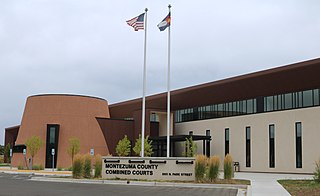
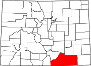
Montezuma County is a county located in the southwest corner of the U.S. state of Colorado. As of the 2020 census, the population was 25,849. The county seat is Cortez.
Las Animas County is a county located in the U.S. state of Colorado. As of the 2020 census, the population was 14,555. The county seat is Trinidad. The county takes its name from the Mexican Spanish name of the Purgatoire River, originally called El Río de las Ánimas Perdidas en el Purgatorio, which means "River of the Lost Souls in Purgatory."
La Plata County is a county located in the U.S. state of Colorado. As of the 2020 census, the population was 55,638. The county seat is Durango. The county was named for the La Plata River and the La Plata Mountains. "La plata" means "the silver" in Spanish.
Delta County is a county located in the U.S. state of Colorado. As of the 2020 census, the population was 31,196. The county seat is Delta.
Bent County is a county located in the U.S. state of Colorado. As of the 2020 census, the population was 5,650. The county seat and only incorporated municipality is Las Animas. The county is named in honor of frontier trader William Bent.
Campo is a Statutory Town located in Baca County, Colorado, United States. The town population was 103 at the 2020 United States Census. The town is situated on the High Plains, straddling U.S. Route 287/385.
The Town of Crawford is a Statutory Town in Delta County, Colorado, United States. The town population was 403 at the 2020 United States Census. The surrounding mesas and valleys support a farming and ranching community.
Haswell is a Statutory Town located in Kiowa County, Colorado, United States. The town population was 71 at the 2020 United States Census.
Cokedale is a Statutory Town located in Las Animas County, Colorado, United States. The town population was 127 at the 2020 United States Census.
Kim is a Statutory Town in Las Animas County, Colorado, United States. The population was 63 at the time of the 2020 United States Census.
Arriba is a Statutory Town located in Lincoln County, Colorado, United States. The town population was 202 at the 2020 United States census. Arriba is the Spanish word for "on high" or "above others."
Collbran is a statutory town located in Mesa County, Colorado, United States. The town's population was 369 at the 2020 Census. Collbran is a part of the Grand Junction, CO Metropolitan Statistical Area.
De Beque is a statutory town located in Mesa County, Colorado. The population was 493 at the time of the 2020 census. De Beque is a part of the Grand Junction, CO Metropolitan Statistical Area. The town consists of a small grid, including a historic downtown featuring a town hall, a tavern, and several commercial businesses in historic structures. The surrounding streets include houses, several churches, and a school.
Cortez is a home rule municipality that is the county seat and the most populous municipality of Montezuma County, Colorado, United States. The city population was 8,766 at the 2020 United States Census.
Log Lane Village is a statutory town in Morgan County, Colorado, United States. The population was 913 at the 2020 census.
Norwood is a Statutory Town in San Miguel County, Colorado, United States. The population was 535 at the 2020 census.
Akron is the Statutory Town that is the county seat and the most populous municipality of Washington County, Colorado, United States. The town population was 1,757 at the 2020 United States Census.
Mesa is a city in Franklin County, Washington, United States. The population was 489 at the 2010 census. The Washington State Office of Financial Management's 2018 estimate placed the population at 513.
History of Branson, Colo. By Odessa M. Booher - Unknown date written - retrieved May 21, 2018