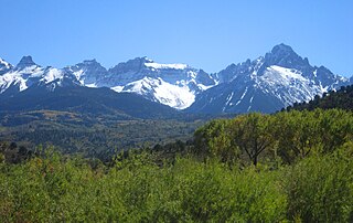
The Sangre de Cristo Mountains are the southernmost subrange of the Rocky Mountains. They are located in southern Colorado and northern New Mexico in the United States. The mountains run from Poncha Pass in South-Central Colorado, trending southeast and south, ending at Glorieta Pass, southeast of Santa Fe, New Mexico. The mountains contain a number of fourteen thousand foot peaks in the Colorado portion, as well as all the peaks in New Mexico which are over thirteen thousand feet.

Mount Bierstadt is a high mountain summit of the Chicago Peaks in the Front Range of the Rocky Mountains of North America. The 14,065-foot (4,287 m) fourteener is located in the Mount Evans Wilderness of Pike National Forest, 9.4 miles (15.1 km) south by east of the Town of Georgetown in Clear Creek County, Colorado, United States. It was named in honor of Albert Bierstadt, the American landscape painter who made the first recorded summit of the mountain in 1863.

Nokhu Crags is a rock formation and mountain summit in the Never Summer Mountains range of the Rocky Mountains of North America. The name is derived from the Arapaho language, Neaha-no-xhu, meaning "Eagles Nest." The 12,490-foot (3,807 m) peak is located in State Forest State Park, 2.5 miles (4.0 km) south of Cameron Pass in Jackson County, Colorado, United States. The summit lies just northwest of the Continental Divide and Rocky Mountain National Park, near the headwaters of the Michigan River. The peak is prominently visible from State Highway 14 and can be seen throughout the southern North Park basin where it is known also known as "the Crags" or "Sleeping Indian" for its resemblance to the form of a supine chief. To the east lie the shallow basins of Snow Lake and the Michigan or American Lakes; to the north lies a snow filled couloir; to the west the mountain descends directly into the deep waters of Lake Agnes; and to the south lie Static Peak, Mount Richthofen, and the remainder of the Never Summer Mountain Range.

Mount Harvard is the third highest summit of the Rocky Mountains of North America and the U.S. state of Colorado. The prominent 14,421-foot (4395.6 m) fourteener is the highest summit of the Collegiate Peaks and the fourth highest summit in the contiguous United States. Mount Harvard is located in the Collegiate Peaks Wilderness of San Isabel National Forest, 11.7 miles (18.9 km) northwest by west of the Town of Buena Vista in Chaffee County, Colorado, United States. The summit of Mount Harvard is the highest point in Chaffee County and is higher than any point in the United States east of its longitude. The mountain was named in honor of Harvard University.

Crestone Needle is a high mountain summit of the Crestones in the Sangre de Cristo Range of the Rocky Mountains of North America. The 14,203-foot (4,329 m) fourteener is located 6.9 miles (11.1 km) east-southeast of the Town of Crestone in Saguache County, Colorado, United States. The Crestones are a cluster of high summits in the Sangre de Cristo Range, comprising Crestone Peak, Crestone Needle, Kit Carson Peak, Challenger Point, Humboldt Peak, and Columbia Point. They are usually accessed from common trailheads.

Handies Peak is a high and prominent mountain summit of the San Juan Mountains range in the Rocky Mountains of North America. The 14,058-foot (4284.8 m) fourteener is located in the Bureau of Land Management Handies Peak Wilderness Study Area, 13.4 miles (21.5 km) southwest by west of the Town of Lake City in Hinsdale County, Colorado, United States.

Mount Oxford is a high mountain summit of the Collegiate Peaks in the Sawatch Range of the Rocky Mountains of North America. The 14,160-foot (4,316 m) fourteener is located in the Collegiate Peaks Wilderness of San Isabel National Forest, 14.2 miles (22.9 km) northwest of the Town of Buena Vista in Chaffee County, Colorado, United States. The mountain was named in honor of the University of Oxford.

Missouri Mountain is a high mountain summit in the Collegiate Peaks of the Sawatch Range of the Rocky Mountains of North America. The 14,074-foot (4,290 m) fourteener is located in the Collegiate Peaks Wilderness of San Isabel National Forest, 15.2 miles (24.5 km) northwest by west of the Town of Buena Vista in Chaffee County, Colorado, United States. Missouri Mountain is separated from its eastern neighbor Mount Belford by Elkhead Pass.

Grizzly Peak is a high and prominent mountain summit of the Collegiate Peaks in the Sawatch Range of the Rocky Mountains of North America. The 13,995-foot (4265.6 m) thirteener is located 2.6 miles (4.2 km) south-southwest of Independence Pass, Colorado, United States, on the Continental Divide separating San Isabel National Forest and Chaffee County from White River National Forest and Pitkin County.

Braddock Peak is a mountain summit in the Never Summer Mountains range of the Rocky Mountains of North America. The 11,972-foot (3,649 m) peak is located in State Forest State Park, 3.0 miles (4.8 km) south-southwest of Cameron Pass in Jackson County, Colorado, United States.

Hallett Peak is a mountain summit in the northern Front Range of the Rocky Mountains of North America. The 12,720-foot (3,877 m) peak is located in the Rocky Mountain National Park Wilderness, 10.1 miles (16.2 km) southwest by west of the Town of Estes Park, Colorado, United States, on the Continental Divide between Grand and Larimer counties.

Winfield Peak is a mountain summit of the Collegiate Peaks in the Sawatch Range of the Rocky Mountains of North America. The 13,084-foot (3,988 m) summit is located in Chaffee County, Colorado, U.S., two miles north of the ghost town of Winfield.

Grizzly Peak is a high mountain summit in the Front Range of the Rocky Mountains of North America. Also known as Grizzly Peak D, the 13,433-foot (4,094 m) thirteener is located in Arapaho National Forest, 2.1 miles (3.4 km) southeast by east of Loveland Pass, Colorado, United States, on the Continental Divide between Clear Creek and Summit counties. Its proximate parent peak is Torreys Peak.

Casco Peak is a high mountain summit in the Sawatch Range of the Rocky Mountains of North America. The 13,915-foot (4,241 m) thirteener is located on the Elbert Massif in San Isabel National Forest, 3.8 miles (6.1 km) east of Independence Pass in Lake County, Colorado, United States.

Clinton Peak is a high mountain summit in the Mosquito Range of the Rocky Mountains of North America. The 13,864-foot (4,226 m) thirteener is located 2.1 miles (3.3 km) east of Fremont Pass, Colorado, United States, on the Continental Divide separating San Isabel National Forest and Lake County from Pike National Forest and Park County.

Emerald Peak is a high mountain summit of the Collegiate Peaks in the Sawatch Range of the Rocky Mountains of North America. The 13,911-foot (4,240 m) thirteener is located in the Collegiate Peaks Wilderness of San Isabel National Forest, 14.7 miles (23.7 km) west-northwest of the Town of Buena Vista in Chaffee County, Colorado, United States.

Ice Mountain is a high mountain summit of the Collegiate Peaks in the Sawatch Range of the Rocky Mountains of North America. The 13,958-foot (4,254 m) thirteener is located in the Collegiate Peaks Wilderness, 17.1 miles (27.5 km) west-northwest of the Town of Buena Vista, Colorado, United States, on the Continental Divide separating San Isabel National Forest and Chaffee County from White River National Forest and Pitkin County.

Garfield Peak is a high mountain summit of the Collegiate Peaks in the Sawatch Range of the Rocky Mountains of North America. The 13,787-foot (4,202 m) thirteener is located 5.6 miles (9.0 km) south-southwest of Independence Pass, Colorado, United States, on the Continental Divide separating San Isabel National Forest and Chaffee County from White River National Forest and Pitkin County. Garfield Peak was named in honor of James A. Garfield, 20th President of the United States.


