
Avadi is a western suburb of Chennai, and the headquarters of Avadi taluk located within the Thiruvallur district of Tamil Nadu, India. Situated at about 22 kilometres (14 mi) from Chennai Central Railway Station, it is one of the four municipal corporations in the Chennai Metropolitan Area and is governed by the Avadi Municipal Corporation. It is surrounded by major defence establishments and is home to various universities and engineering colleges. The neighborhood is served by Avadi Railway Station of the Chennai Suburban Railway and just 7 km from the upcoming Karayanchavadi Metro of Chennai Metro Rail. As of 2011, Avadi had a population of 345,996, which is 10th most populous place in Tamil Nadu. It is home to the Heavy Vehicles Factory (HVF), Ordnance Factory Board (ODF) which houses Engine Factory and Combat Vehicles Research and Development Establishment (CVRDE). The lake in Avadi was known as Paaleripattu, which is now found only in very old land documents.

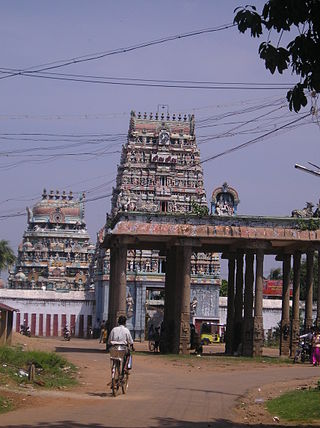
Tiruvallur is a Grade I municipality in the Indian state of Tamil Nadu. It is located on the banks of Coovum river about 46 km (29 mi) from downtown Chennai (Madras) and just 5 km from megacity border, in the western part of the Chennai Metropolitan Area (CMA). It is a satellite town of Chennai and is the administrative headquarters of Tiruvallur District. The town is known for the Veeraraghava Swamy Temple, one of the 108 sacred shrines of Vaishnavites. The tank festival is held at a pond near this temple. A Shiva temple near this shrine which is popular among the locals. There is also a 40-foot (12 m) tall Viswaroopa Panchamukha Hanuman temple, where the murti is made of a single green granite stone.

Ambattur is a northwestern part of Chennai, India. It is located in Ambattur taluk of the Chennai District, surrounded by Avadi, Anna Nagar, Korattur, Padi, Mogappair, Kallikuppam, Surapet, Ayappakkam, Athipet and Thiruverkadu. It covers an area of 40.36 km2 (15.58 sq mi). The neighbourhood is served by Ambattur railway station. Ambattur was once a village with large extents of agricultural farm lands irrigated by the sprawling Ambattur Lake. Today, the area is a bustling urban hub teeming with industrial and commercial activity.

Thiruverkadu is a Western suburb of Chennai, Tamil Nadu. It comes under Thiruvallur district administration. It is famous for its Devi Karumariamman Temple. There is also Vedapureeswarar Temple in Thiruverkadu, where Lord Shiva and Goddess Parvathi are seen in their wedding pose inside the sanctum sanctorum. As of 2011, the town had a population of 62,289. It is a town with rich cultural heritage and also a fast-growing areas in the city.
Pammal is a southern suburb in Chennai, Tamil Nadu, India.
Villivakkam is a neighbourhood of Chennai, Tamil Nadu, India. It is served by the Villivakkam railway station on the Chennai Central–Arakkonam suburban section. Villivakkam is the largest state assembly constituency in Tamil Nadu in terms of number of voters.
Iyyappanthangal is a neighborhood to the west of Chennai, Tamilnadu, India. It comes under Mangadu Municipality of Chennai Metropolitan Area (CMA), governed by CMDA. It is located 20 kilometres (12 mi) away from Fort St George on the Mount-Poonamallee Road. The nearest railway stations are at Guindy about 11 kilometres (6.8 mi) away and Avadi about 12 kilometres (7.5 mi) away. The Porur Junction where a much-needed road overbridge on the busy Guindy–Poonamallee stretch was built after a very long delay of nearly five years is just about 2 km from Iyyapanthangal and the Poonamallee Junction is just about 6 km from the town.
Korattur is a neighbourhood situated in the western part of Chennai. It is a part of the Ambattur Zone of Chennai Corporation and located along the Chennai-Bangalore/Mumbai railroad about 12 km from the Chennai Central. It is developed with TNHB Layouts similar to Anna Nagar and the southern section of Korattur located near Padi is often considered to be an integral part of Anna Nagar.
Padi is a locality and neighbourhood in the city of Chennai, India. It was named as Thiruvaaipadi and Later called as Padi short form of Thiruvaaipadi, Sundarar, came to Padi and sang songs in the Lord Shiva Temple. Padi exactly 13 km from the city's Kilometer Zero is a latest included part of the city. MTH Road, now unofficially known as the CTH Road, passes through Padi. Padi is basically an industrial area and its infrastructure and living conditions have made this place popular among the working class. Arulmigu Thiruvalithayam Temple in Padi is one of the famous Guru Bhagawan temples in Chennai. This temple is under the control of Hindu Aranilayathurai. Every year Thai Kirthigai is one of the big festival in Padi. Another nearby temple is the Padavattamman Temple.
Anna Nagar West is a township in Chennai, India. It is the western part of Anna Nagar and is one of the most socially active locations in Chennai. The area serves as a major transport and residential hub within the city. It is also connected by the contemporary metro rail system. The region contains several schools and hospitals. It is mostly a public service concentrated hub located in a residential area. Millennium Park is the largest park within the region. It has a bus terminus belonging to the Metropolitan Transport Corporation.
Thirumullaivoyal is a western neighbourhood of Chennai the capital of the India state of Tamil Nadu, under Avadi City Municipal Corporation Limits. It is located in the Chennai Metropolitan Area in Thiruvallur district, 3 km (1.9 mi) from Avadi and 3 km (1.9 mi) from Ambattur O.T Bus depot. The neighbourhood is served by Thirumullaivoyal railway station and Annanur Railway Station. The region was historically part of Thondaimandalam, a region in Chola Empire during 9th century CE.
Annanur is a western neighbourhood of Chennai, India. It is located near Ambattur and lies in Tiruvallur District. It comes under the Avadi Municipal Corporation. It is located about 20 km from the city centre.
Muthapudupet is a sublocality of Pattabiram in Avadi which is a neighbourhood in Chennai comes under the Avadi Municipal Corporation limit and Chennai Metropolitan area. Muthapudupet is around 700 metres from Pattabiram E Depot Railway Station, 2.5km from TIDEL Park and 7 km from Avadi Junction and 29 km from Chennai Central. The Chennai Outer Ring Road (ORR) and CTH Road passes near Muthapudupet
Located in the Indian state of Tamil Nadu, Vinayagapuram is a northern region of Chennai city's Chennai district.
Mogappair is a residential neighborhood in north-western Chennai, India. It is located west of the Jawaharlal Nehru Road and is part of the Ambattur zone (7) of the Greater Chennai Corporation. There are industrial estates to the north and west, namely, Padi and Ambattur. Mogappair is located 3 km from Anna Nagar, 8 km from Avadi and 5 km from Ambattur.

ICF Colony is a locality in Ayanavaram neighbourhood in Chennai, Tamil Nadu, India, where the Integral Coach Factory, (ICF) is located. The area also consists of a bus depot and the ICF Hospital. The locality has an MTC bus depot connecting the locality to areas such as Thiruvanmiyur.

Thirumullaivoyal railway station is one of the railway stations on the Chennai Central–Arakkonam section of the Chennai Suburban Railway Network. It serves the neighbourhoods of moondru nagar, Jayalakshmi Nagar, Senthil Nagar and Thirumullaivoyal and a suburb of Chennai located 17 km west of the city centre. It is situated at Senthil Nagar near Ambattur and has an elevation of 21.73 m above sea level.
Chennai–Thiruvallur High Road, formerly known as Madras–Thiruvallur High Road, is one of the chief routes connecting the northwestern suburbs of Chennai, India. Starting from Padi Junction, the road connects the neighbourhoods of Padi, Ambattur, Thirumullaivoyil, Avadi, Pattabiram, Thirunindravur, and Thiruvallur. It is one of the four national highways that radiates out of Chennai city and is part of National Highway 205.
Ayappakkam is a Western suburb of Chennai in Thiruvallur district in the Indian state of Tamil Nadu. Ayapakkam is currently a village panchayat surrounded by Thiruverkadu municipality, Avadi corporation and Greater Chennai Corporations.
Kallikuppam is a locality in Ambattur, which is a large neighbourhood in Chennai City.


