Campo, Colorado

Last updated

Campo, Colorado
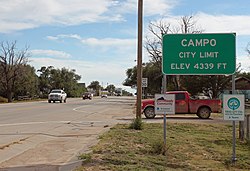
Campo, Colorado.JPG
Entering Campo from the north on U.S. Route 287/385 (2015)
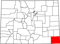
Baca County Colorado Incorporated and Unincorporated areas Campo Highlighted 0811645.svg
Location within Baca County and Colorado
Coordinates: 37°06′18″N102°34′47″W / 37.1050190°N 102.5796377°W / 37.1050190; -102.5796377 [2]
Country United States
State Colorado
County Baca County [1]
Incorporated March 6, 1950 [3]
Government
  Type Statutory Town [1]
Area
[4]
  Total0.144 sq mi (0.374 km2)
  Land0.144 sq mi (0.374 km2)
  Water0.000 sq mi (0.000 km2)
Elevation
[2]
4,344 ft (1,324 m)
Population
 (2020) [4]
  Total103
  Density713/sq mi (275/km2)
Time zone UTC−7 (MST)
  Summer (DST) UTC−6 (MDT)
ZIP Code
81029 [5]
Area code 719
FIPS code 08-11645 [2]
GNIS ID 196360 [2]
Website Town Website

Campo is a statutory town located in Baca County, Colorado, United States. [2] [1] The town population was 103 at the 2020 United States Census. [4] The town is situated on the High Plains, straddling U.S. Route 287/385.

Contents

History

Campo is a name derived from a Spanish word meaning "field". [6] A post office called Campo was established in 1913, [7] and the town grew around it.

Geography

Campo is located just north of the Oklahoma border in southern Baca County. Via U.S. Route 287/385 it is 21 miles (34 km) north to Springfield, the county seat, and 27 miles (43 km) south to Boise City, Oklahoma.

At the 2020 United States Census, the town had a total area of 92 acres (0.374 km2), all of it land. [4]

Picture Canyon, in the Comanche National Grassland, is to the southwest. [8] The canyon includes scenic vistas, unique rock formations, rolling hills, and rock art from Plains Indian cultures. [9]

Climate

Climate data for Campo, Colorado
MonthJanFebMarAprMayJunJulAugSepOctNovDecYear
Mean daily maximum °F (°C)47
(8)
51
(11)
59
(15)
69
(21)
78
(26)
88
(31)
93
(34)
91
(33)
83
(28)
71
(22)
58
(14)
47
(8)
69.5
(20.8)
Mean daily minimum °F (°C)22
(−6)
25
(−4)
32
(0)
40
(4)
51
(11)
60
(16)
66
(19)
65
(18)
56
(13)
43
(6)
32
(0)
23
(−5)
42.9
(6.1)
Source: Accuweather [10]

Demographics

Historical population
CensusPop.Note
1950 266
1960 235−11.7%
1970 206−12.3%
1980 185−10.2%
1990 121−34.6%
2000 15024.0%
2010 109−27.3%
2020 103−5.5%
U.S. Decennial Census

As of the census [11] of 2000, there were 150 people, 55 households, and 44 families residing in the town. The population density was 1,086.4 inhabitants per square mile (419.5/km2). There were 79 housing units at an average density of 572.2 per square mile (220.9/km2). The racial makeup of the town was 95.33% White, 3.33% Native American, and 1.33% from two or more races. Hispanic or Latino of any race were 4.67% of the population.

There were 55 households, out of which 40.0% had children under the age of 18 living with them, 70.9% were married couples living together, 5.5% had a female householder with no husband present, and 20.0% were non-families. 18.2% of all households were made up of individuals, and 10.9% had someone living alone who was 65 years of age or older. The average household size was 2.73 and the average family size was 3.11.

In the town, the population was spread out, with 30.7% under the age of 18, 4.7% from 18 to 24, 25.3% from 25 to 44, 22.7% from 45 to 64, and 16.7% who were 65 years of age or older. The median age was 38 years. For every 100 females, there were 105.5 males. For every 100 females age 18 and over, there were 92.6 males.

The median income for a household in the town was $20,875, and the median income for a family was $21,375. Males had a median income of $19,167 versus $19,375 for females. The per capita income for the town was $7,818. There were 33.3% of families and 45.6% of the population living below the poverty line, including 73.2% of under eighteens and 8.3% of those over 64.

See also

Related Research Articles

<span class="mw-page-title-main">Saguache County, Colorado</span> County in Colorado, United States

Saguache County is a county located in the U.S. state of Colorado. As of the 2020 census, the population was 6,368. The county seat is Saguache.

<span class="mw-page-title-main">Baca County, Colorado</span> County in Colorado, United States

Baca County is a county located in the U.S. state of Colorado. As of the 2020 census, the population was 3,506. The county seat is Springfield. Located at the southeast corner of Colorado, the county shares state borders with Kansas, New Mexico, and Oklahoma.

<span class="mw-page-title-main">Cameron, Arizona</span> Census-designated place in Coconino County, Arizona, United States

Cameron is a census-designated place (CDP) in Coconino County, Arizona, United States, on the Navajo Nation. The population was 885 at the 2010 census. Most of the town's economy is tourist food and craft stalls, restaurants, and other services for north–south traffic from Flagstaff and Page. There is a ranger station supplying information and hiking permits for the Navajo Nation. There is also a large craft store run by the Nation itself. It is named after Ralph H. Cameron, one of the two senators first appointed to U.S. Congress for Arizona, upon its federal recognition of statehood.

<span class="mw-page-title-main">Springfield, Colorado</span> Town in Colorado, United States

Springfield is a statutory town, county seat, and most populous town in Baca County, Colorado, United States. The population was 1,325 at the 2020 census.

<span class="mw-page-title-main">Jamestown, Colorado</span> Town in Colorado, United States

The historic Town of Jamestown is a Statutory Town in Boulder County, Colorado, United States. The population was 256 at the 2020 United States Census, down from 274 in 2010. It was named for James Smith, an early discoverer of gold. Jamestown was hit hard by the September 2013 Colorado floods when the town was isolated due to road damage from the rains and the flooding of James Creek. Under a mandatory evacuation order, most residents were airlifted to safety under the direction of the Colorado National Guard to nearby Boulder.

<span class="mw-page-title-main">Cheyenne Wells, Colorado</span> Town in Colorado, United States

Cheyenne Wells is the Statutory Town that is the county seat and the most populous municipality of Cheyenne County, Colorado, United States. The town population was 758 at the 2020 United States Census.

<span class="mw-page-title-main">Crawford, Colorado</span> Town in Colorado, United States

The Town of Crawford is a Statutory Town in Delta County, Colorado, United States. The town population was 403 at the 2020 United States Census. The surrounding mesas and valleys support a farming and ranching community.

<span class="mw-page-title-main">Dove Creek, Colorado</span> Town in Colorado, United States

Dove Creek is a statutory town that is the county seat and the most populous municipality of Dolores County, Colorado, United States. The town population was 635 at the 2020 United States Census. The community takes its name from the nearby Dove Creek. Dove Creek is the self-proclaimed Pinto Bean Capital of the World.

<span class="mw-page-title-main">Red Cliff, Colorado</span> Town in Colorado, United States

Red Cliff is a statutory town in Eagle County, Colorado, United States. The population was 257 at the 2020 census. The town is a former mining camp situated in the canyon of the upper Eagle River just off U.S. Highway 24 north of Tennessee Pass. The town site is concealed below the highway and is accessible by a side road leading to Shrine Pass in the Sawatch Range.

<span class="mw-page-title-main">Haswell, Colorado</span> Town in Colorado, United States

Haswell is a statutory town located in Kiowa County, Colorado, United States. The town population was 71 at the 2020 United States Census.

<span class="mw-page-title-main">Bethune, Colorado</span> Town in Kit Carson County, Colorado, United States

Bethune is a Statutory Town located in Kit Carson County, Colorado, United States. The town population was 183 at the 2020 United States Census. It is located along U.S. Highway 24 that is north of an exit on Interstate 70.

<span class="mw-page-title-main">Cokedale, Colorado</span> Town in Colorado, United States

Cokedale is a Statutory Town located in Las Animas County, Colorado, United States. The town population was 127 at the 2020 United States Census.

<span class="mw-page-title-main">Genoa, Colorado</span> Town in Lincoln County, Colorado, United States

Genoa is a statutory town located in Lincoln County, Colorado, United States. The town population was 153 at the 2020 United States Census.

<span class="mw-page-title-main">Crook, Colorado</span> Town in Colorado, United States

The Town of Crook is a Statutory Town in Logan County, Colorado, United States. The town population was 133 at the 2020 United States Census. Crook is a part of the Sterling, CO Micropolitan Statistical Area.

<span class="mw-page-title-main">De Beque, Colorado</span> Town in Colorado, United States

De Beque is a statutory town located in Mesa County, Colorado. The population was 493 at the time of the 2020 census. De Beque is a part of the Grand Junction, CO Metropolitan Statistical Area. The town consists of a small grid, including a historic downtown featuring a town hall, a tavern, and several commercial businesses in historic structures. The surrounding streets include houses, several churches, and a school.

<span class="mw-page-title-main">Wiggins, Colorado</span> Town in Colorado, United States

Wiggins is a statutory town in Morgan County, Colorado, United States. The population was 1,401 as of the 2020 census, up from 893 at the 2010 census.

<span class="mw-page-title-main">Granada, Colorado</span> Town in Colorado, United States

Granada is a statutory town in Prowers County, Colorado, United States. The town population was 445 at the 2020 United States Census.

<span class="mw-page-title-main">Center, Colorado</span> Town in Saguache and Rio Grande counties in Colorado, United States

The Town of Center is a Statutory Town located in Saguache and Rio Grande counties in Colorado, United States. The town's population was 1,929 at the 2020 United States Census with 1,885 residing in Saguache County and 44 residing in Rio Grande County.

<span class="mw-page-title-main">Bonanza, Colorado</span> Town in Saguache County, Colorado, United States

Bonanza is a statutory town located in Saguache County, Colorado, United States. The town population was 17 at the 2020 United States Census. Formerly known as Bonanza City, Bonanza is a largely abandoned former silver mining town. Bonanza is a Spanish language word meaning prosperity.

<span class="mw-page-title-main">Dacono, Colorado</span> City in Colorado, United States

Dacono is a home rule municipality located in southwestern Weld County, Colorado, United States. The city population was 6,297 at the 2020 United States Census, an increase of +51.66% since the 2010 United States Census. Dacono is a part of the Greeley, CO Metropolitan Statistical Area and the Front Range Urban Corridor.

References

  1. 1 2 3 4 "Active Colorado Municipalities". Colorado Department of Local Affairs . Retrieved October 15, 2021.
  2. 1 2 3 4 5 "Campo, Colorado", Geographic Names Information System , United States Geological Survey, United States Department of the Interior
  3. "Colorado Municipal Incorporations". State of Colorado, Department of Personnel & Administration, Colorado State Archives. December 1, 2004. Retrieved September 2, 2007.
  4. 1 2 3 4 "Decennial Census P.L. 94-171 Redistricting Data". United States Census Bureau, United States Department of Commerce. August 12, 2021. Retrieved September 2, 2021.
  5. "ZIP Code Lookup". United States Postal Service. Archived from the original (JavaScript/HTML) on September 3, 2007. Retrieved September 4, 2007.
  6. Dawson, John Frank (1954). Place names in Colorado: why 700 communities were so named, 150 of Spanish or Indian origin. Denver, CO: The J. Frank Dawson Publishing Co. p. 12.
  7. "Post offices". Jim Forte Postal History. Archived from the original on March 6, 2016. Retrieved June 24, 2016.
  8. "Campo, Colorado to Picture Canyon, CO". Google Maps. Retrieved January 3, 2021.
  9. "Picture Canyon". USDA Forest Service. Retrieved January 3, 2021.
  10. "Campo Weather" . Retrieved May 27, 2015.
  11. "U.S. Census website". United States Census Bureau . Retrieved January 31, 2008.