Centenary Heights, Queensland

Last updated

Centenary Heights
Toowoomba,  Queensland
Australia Queensland location map.svg
Red pog.svg
Centenary Heights
Coordinates 27°35′10″S151°57′43″E / 27.5861°S 151.9619°E / -27.5861; 151.9619 (Centenary Heights (centre of locality))
Population6,063 (2016 census) [1]
 • Density1,960/km2 (5,070/sq mi)
Postcode(s) 4350
Area3.1 km2 (1.2 sq mi)
Time zone AEST (UTC+10:00)
Location
LGA(s) Toowoomba Region
State electorate(s) Toowoomba South
Federal division(s) Groom
Suburbs around Centenary Heights:
South Toowoomba South Toowoomba Rangeville
Kearneys Spring Centenary Heights Rangeville
Kearneys Spring Middle Ridge Middle Ridge

Centenary Heights is a residential locality of Toowoomba in the Toowoomba Region, Queensland, Australia. [2] In the 2016 census, Centenary Heights had a population of 6,063 people. [1]

Contents

Geography

Centenary Heights is located 4 kilometres (2 mi) south-east from the central business district. [2]

History

Previously part of Middle Ridge, the area was named Centenary Heights in 1960 in honour of the separation of Queensland from New South Wales in 1859. [2]

Toowoomba Opportunity School (later Toowoomba Special School) opened on 26 January 1960 at 58 Ramsay Street ( 27°34′41″S151°57′52″E / 27.5780°S 151.9644°E / -27.5780; 151.9644 (Toowoomba Opportunity/Special School (former)) ) on part of the site reserved for a new secondary school. The opportunity school had its origins in the special education ("opportunity classes") commenced at Toowoomba South State School in South Toowoomba in 1923. [3] [4] [5] The school officially closed on 12 December 1997, [6] but the site continued to operate as the 2nd campus of the Clifford Park Special School (which had its main campus in Newtown). [7] Since 2009, the site has been used as the Toowoomba Positive Learning Centre. [8]

St Thomas More's Catholic Primary School opened 23 January 1961. [9] [10]

Centenary Heights State High School opened on 30 January 1968 at 60 Ramsay Street, adjacent to the special school. [9] [10]

Gabbinbar State School opened on 24 January 1972. [9] [10]

Martin Luther Primary School opened 24 January 1977. [9] [10]

In the 2016 census, Centenary Heights had a population of 6,063 people. [1]

Education

Gabbinar State School Gabbinar State School.jpg
Gabbinar State School

Gabbinbar State School is a government primary (Prep–6) school for boys and girls at 189 Stenner Street ( 27°35′45″S151°58′09″E / 27.5959°S 151.9692°E / -27.5959; 151.9692 (Gabbinbar State School) ). [11] [12] In 2017, the school had an enrolment of 386 students with 36 teachers (34 full-time equivalent) and 16 non-teaching staff (12 full-time equivalent). [13] It includes a special education program. [11] [14]

St Thomas More's Primary School is a Catholic primary (Prep–6) school for boys and girls at 152 South Street ( 27°34′48″S151°57′43″E / 27.5801°S 151.9620°E / -27.5801; 151.9620 (St Thomas More's Primary School) ). [11] [15] In 2017, the school had an enrolment of 396 students with 25 teachers (22 full-time equivalent) and 14 non-teaching staff (9 full-time equivalent). [13]

Martin Luther Primary School is a private primary (Prep–6) campus of Concordia Lutheran College for boys and girls at 402 Hume Street ( 27°35′29″S151°57′16″E / 27.5915°S 151.9544°E / -27.5915; 151.9544 (Concordia Lutheran College) ). [11] [16] In 2017, the school had an enrolment of 644 students with 68 teachers (48 full-time equivalent) and 75 non-teaching staff (45 full-time equivalent). [13]

Centenary Heights State High School is a government secondary (7–12) school for boys and girls at 60 Ramsay Street ( 27°34′46″S151°57′49″E / 27.5794°S 151.9637°E / -27.5794; 151.9637 (Centenary Heights State High School) ). [11] [17] In 2017, the school had an enrolment of 1,625 students with 131 teachers (123 full-time equivalent) and 59 non-teaching staff (45 full-time equivalent). [13] It includes a special education program. [11] [18]

Toowoomba Positive Learning Centre (also known as the Denise Kalble campus) is a specific purpose secondary (7–12) school at 58 Ramsay Street ( 27°34′44″S151°57′51″E / 27.5789°S 151.9642°E / -27.5789; 151.9642 (Toowoomba Positive Learning Centre) ). [11] It is for children who have disengaged from conventional schooling with the aim to re-engage the children with conventional schooling or vocational pathways. [8] [19] [20]

Amenities

There are a number of parks in the area:

Emmerson Park has two separate play areas, a barbecue, and a significant planting of mature trees. [22]

Horners Reserve has one small park and a large town water storage reserve. [23]

Related Research Articles

<span class="mw-page-title-main">Clifton, Queensland</span> Town in Queensland, Australia

Clifton is a rural town and locality in the Toowoomba Region, Queensland, Australia. In the 2016 census, Clifton had a population of 1,456 people.

Glenvale is a semi-rural residential locality in the Toowoomba Region, Queensland, Australia. It is a suburb of Toowoomba. In the 2016 census, Glenvale had a population of 6,353 people.

<span class="mw-page-title-main">Darling Heights, Queensland</span> Suburb of Toowoomba, Queensland, Australia

Darling Heights is a rural residential locality in the Toowoomba Region, Queensland, Australia. In the 2021 census, Darling Heights had a population of 5,157 people.

<span class="mw-page-title-main">Greenmount, Queensland (Toowoomba Region)</span> Town in Queensland, Australia

Greenmount is a rural town and locality in the Toowoomba Region, Queensland, Australia. In the 2016 census, the locality of Greenmount had a population of 699 people.

<span class="mw-page-title-main">Toowoomba City, Queensland</span> Suburb of Toowoomba, Queensland, Australia

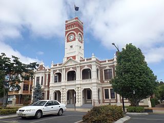
Toowoomba City is an urban locality in the Toowoomba Region, Queensland, Australia. It is the central suburb of Toowoomba, containing its central business district and informally known as the Toowoomba CBD. In the 2021 census, Toowoomba City had a population of 2,321 people.

<span class="mw-page-title-main">Vale View, Queensland</span> Suburb of Toowoomba, Queensland, Australia

Vale View is a rural locality in the Toowoomba Region, Queensland, Australia. In the 2016 census, Vale View had a population of 472 people.

<span class="mw-page-title-main">East Toowoomba, Queensland</span> Suburb of Toowoomba, Queensland, Australia

East Toowoomba is a residential locality in Toowoomba in the Toowoomba Region, Queensland, Australia. In the 2016 census, East Toowoomba had a population of 5,244 people.

<span class="mw-page-title-main">Wellcamp, Queensland</span> Suburb of Toowoomba Region, Queensland, Australia

Wellcamp is a rural locality in the Toowoomba Region, Queensland, Australia. In the 2016 census, Wellcamp had a population of 295 people.

<span class="mw-page-title-main">Wilsonton, Queensland</span> Suburb of Toowoomba, Queensland, Australia

Wilsonton is an urban locality in the Toowoomba Region, Queensland, Australia. In the 2021 census, Wilsonton had a population of 5,891 people.

Wilsonton Heights is a residential locality of Toowoomba in the Toowoomba Region, Queensland, Australia. In the 2021 census, Wilsonton Heights had a population of 2,747 people.

<span class="mw-page-title-main">Harristown, Queensland</span> Suburb of Toowoomba, Queensland, Australia

Harristown is a residential locality in Toowoomba in the Toowoomba Region, Queensland, Australia. In the 2021 census, Harristown had a population of 9,081 people.

Kearneys Spring is a residential locality in Toowoomba in the Toowoomba Region, Queensland, Australia. In the 2021 census, Kearneys Spring had a population of 9,419 people.

<span class="mw-page-title-main">Middle Ridge, Queensland</span> Suburb of Toowoomba, Queensland, Australia

Middle Ridge is a residential locality of Toowoomba in the Toowoomba Region, Queensland, Australia. In the 2021 census, Middle Ridge had a population of 7,595 people.

<span class="mw-page-title-main">Mount Lofty, Queensland</span> Suburb of Toowoomba, Queensland, Australia

Mount Lofty is a residential locality on the north-eastern edge of the suburban area of Toowoomba, in the Toowoomba Region, Queensland, Australia. In the 2016 census, Mount Lofty had a population of 3,775 people.

<span class="mw-page-title-main">Newtown, Queensland (Toowoomba)</span> Suburb of Toowoomba, Queensland, Australia

Newtown is a residential locality in Toowoomba in the Toowoomba Region, Queensland, Australia. In the 2021 census, Newtown had a population of 10,039 people.

<span class="mw-page-title-main">Rangeville, Queensland</span> Suburb of Toowoomba, Queensland, Australia

Rangeville is a residential locality in Toowoomba in the Toowoomba Region, Queensland, Australia. In the 2021 census, Rangeville had a population of 8,668 people.

<span class="mw-page-title-main">South Toowoomba, Queensland</span> Suburb of Toowoomba, Queensland, Australia

South Toowoomba is an suburban locality in Toowoomba in the Toowoomba Region, Queensland, Australia. In the 2021 census, South Toowoomba had a population of 5,512 people.

<span class="mw-page-title-main">Mount Tyson, Queensland</span> Town in Queensland, Australia

Mount Tyson is a rural town and locality in the Toowoomba Region, Queensland, Australia. In the 2016 census, the locality of Mount Tyson had a population of 285 people.

<span class="mw-page-title-main">East Greenmount, Queensland</span> Suburb of Toowoomba Region, Queensland, Australia

East Greenmount is a rural town and locality in the Toowoomba Region, Queensland, Australia. In the 2016 census, the locality of East Greenmount had a population of 361 people.

Ramsay is a rural locality in the Toowoomba Region, Queensland, Australia. In the 2016 census Ramsay had a population of 348 people.

References

  1. 1 2 3 Australian Bureau of Statistics (27 June 2017). "Centenary Heights (SSC)". 2016 Census QuickStats. Retrieved 20 October 2018. OOjs UI icon edit-ltr-progressive.svg
  2. 1 2 3 "Centenary Heights – locality in Toowoomba Region (entry 47910)". Queensland Place Names. Queensland Government . Retrieved 7 March 2022.
  3. "Toowoomba South State School (entry 602824)". Queensland Heritage Register . Queensland Heritage Council. Retrieved 1 August 2014.
  4. "Legislative Assembly: Tuesday, 11 October 1966" (PDF). Queensland Parliamentary Debates (Hansard). 11 October 1966. p. 841. Archived (PDF) from the original on 2 May 2022. Retrieved 2 May 2022.
  5. "9242-112 Middle Ridge" (Map). Queensland Government. 1985. Archived from the original on 2 May 2022. Retrieved 2 May 2022.
  6. "Queensland state school - centre closures" (PDF). Queensland Government . 20 August 2013. Archived (PDF) from the original on 20 March 2022. Retrieved 7 April 2022.
  7. Queensland Family History Society (2010), Queensland schools past and present (Version 1.01 ed.), Queensland Family History Society, ISBN   978-1-921171-26-0
  8. 1 2 "Denise Kable Campus". Denise Kable Campus. 20 January 2020. Archived from the original on 13 March 2022. Retrieved 2 May 2022.
  9. 1 2 3 4 Queensland Family History Society (2010), Queensland schools past and present (Version 1.01 ed.), Queensland Family History Society, ISBN   978-1-921171-26-0
  10. 1 2 3 4 "Opening and closing dates of Queensland Schools". Queensland Government . Retrieved 18 April 2019.
  11. 1 2 3 4 5 6 7 "State and non-state school details". Queensland Government. 9 July 2018. Archived from the original on 21 November 2018. Retrieved 21 November 2018.
  12. "Gabbinbar State School". Gabbinbar State School. 14 June 2022. Retrieved 23 September 2023.
  13. 1 2 3 4 "ACARA School Profile 2017". Archived from the original on 22 November 2018. Retrieved 22 November 2018.
  14. "Gabbinbar SS - Special Education Program". Archived from the original on 18 March 2020. Retrieved 21 November 2018.
  15. "St Thomas More's Primary School". Archived from the original on 4 March 2022. Retrieved 21 November 2018.
  16. "Concordia Lutheran College". Archived from the original on 31 January 2019. Retrieved 21 November 2018.
  17. "Centenary Heights State High School". Centenary Heights State High School. 1 March 2022. Retrieved 15 February 2023.
  18. "Centenary Heights SHS - Special Education Program". Archived from the original on 7 March 2019. Retrieved 21 November 2018.
  19. "Our school". Denise Kable Campus. 20 January 2020. Archived from the original on 1 March 2022. Retrieved 2 May 2022.
  20. "Positive Learning Centres". Education. 6 April 2018. Archived from the original on 8 October 2020. Retrieved 2 May 2022.
  21. 1 2 3 4 "Land for public recreation - Queensland". Queensland Open Data. Queensland Government. 20 November 2020. Archived from the original on 22 November 2020. Retrieved 22 November 2020.
  22. "TRC Emmerson Park". Archived from the original on 24 October 2014. Retrieved 24 October 2014.
  23. "TRC Horners Reserve". Archived from the original on 24 October 2014. Retrieved 24 October 2014.