Jaba', Haifa

Last updated

Contents

Jaba'
Dscheba, [1] Jeba [2]
Amir sheikh north Jaba.jpg
Tomb of Shaykh Amir, [4] Jaba, in 2013
Etymology: Hill [5]
Historical map series for the area of Jaba', Haifa (1870s).jpg 1870s map
Historical map series for the area of Jaba', Haifa (1940s).jpg 1940s map
Historical map series for the area of Jaba', Haifa (modern).jpg modern map
Historical map series for the area of Jaba', Haifa (1940s with modern overlay).jpg 1940s with modern overlay map
A series of historical maps of the area around Jaba', Haifa (click the buttons)
Mandatory Palestine location map.svg
Red pog.svg
Jaba'
Location within Mandatory Palestine
Coordinates: 32°39′15″N34°57′47″E / 32.65417°N 34.96306°E / 32.65417; 34.96306
Palestine grid 146/228
Geopolitical entity Mandatory Palestine
Subdistrict Haifa
Date of depopulation24–26 July 1948 [6]
Area
[7]
  Total
7,012  dunams (7.012 km2 or 2.707 sq mi)
Population
 (1945)
  Total
1,140 [8] [7]
Cause(s) of depopulationMilitary assault by Yishuv forces
Current Localities Geva Karmel [9] [10]

Jaba' (Arabic : جبع), also known as Gaba, or Geba, in historical writings, was a Palestinian Arab village in the Haifa Subdistrict. It was depopulated during the 1948 Arab-Israeli War on July 24, 1948, as part of Operation Shoter. It was located 18.5 km south of Haifa, near Carmel, and ca. 3.25 kilometers (2.02 mi) east of the Mediterranean Sea.

History

Classic era

Emil Schürer, writing in 1891, identifies this site with a village featuring prominently in the writings of the Jewish historian, Josephus. [11] In the late 1st century BCE, Herod the Great had built a village for his veteran cavalry, and, according to E. Schürer, called this town the city of horsemen. [12] [13]

Archaeologist Benjamin Mazar, disputing Schürer in 1957, thought that Gaba of the Horsemen (Geba), mentioned by Josephus in The Jewish War 3.3.1, ought to be identified with the ruin Ḫirbet el-Ḥârithîye (now Sha'ar HaAmakim), since in relation to Simonias, it better fits Josephus' description of Gaba / Gibea (Greek : Γάβα) in Vita § 24 being distant from Simonias 60 stadia (about 11 km.), in addition to the fact that in relation to Besara (Beit She'arin), Gaba / Gibea (Ḫirbet el-Ḥârithîye) stood at a distance of only 20 stadia (about 4 km.) from Besara, also in agreement with Josephus. [14] [15] [16]

Ottoman era

Jaba' was incorporated into the Ottoman Empire in 1517, like all of Palestine. During the 16th and 17th centuries, Jaba' belonged to the Turabay Emirate (1517-1683), which encompassed also the Jezreel Valley, Haifa, Jenin, Beit She'an Valley, northern Jabal Nablus, Bilad al-Ruha/Ramot Menashe, and the northern part of the Sharon plain. [17] [18]

In the 1596 tax registers, it was part of the nahiya ("subdistrict") of Jabal Atlit, part of the larger Sanjak of Lajjun. It had a population of 18 households, all Muslims. The inhabitants paid a fixed tax rate of 25% on agricultural products, including wheat, barley, summer crops, goats and beehives, in addition to occasional revenues; a total of 7,800 akçe. [19] [20]

In 1859, the English Consul Rogers found the population to be 150 souls, with 18 feddans of cultivation. [2]

In 1873, the PEF's Survey of Western Palestine (SWP) visited and found: “There are two closed rock tombs in the ledge south of the village, and a third with a courtyard 14 feet square, sunk 2 feet ; two doors lead into chambers. One has three loculi, one on each wall ; the other has two loculi and a recess 5 feet 6 inches, with two parallel graves under one arcosolium placed like kokim with the feet to the chamber. This is therefore a transitional example. (Compare Sheikh Bureik)

There are several caves north of the village, and another tomb at the head of the valley forming the recess in which the village stands." [21]

In 1882, the SWP described it: "A small village in a recess on the hill-slope close to the plain ; the houses principally of stone. It has a good olive-yard on the west below the village, in which yard the Survey Camp was placed. The water-supply is from a well on the north-west, which has a wheel and troughs. The place seems ancient, having rock-cut tombs and caves. [2]

Jaba' had an elementary school for boys, which was founded by the Ottomans in 1885. [22]

An illustration of a lead weight (62x55mm, 212.2 gram) found in 1981 at Tel Shush, with Greek inscription of the city "Gabe", identified as "Geva' Parashim. Lead Weight found at Tel Shush.svg
An illustration of a lead weight (62x55mm, 212.2 gram) found in 1981 at Tel Shush, with Greek inscription of the city "Gabe", identified as "Geva' Parashim.

British Mandate era

In the British Mandate of Palestine period, in the 1922 census of Palestine Jaba had a population of 523; all Muslims, [23] increasing in the 1931 census to 762; 2 Christians and the rest Muslim, in a total of 158 houses. [24]

In the 1945 statistics this had increased to 1,140, all Muslims [8] with a total of 7,012 dunams of land. [7] Of this, 450 dunums were plantations or irrigable land, 4,255 were for cereals, [25] while 60 dunams were classified built-up, (urban), land. [26]

The site has several ancient ruins, including mosaics and tombs. [22]

Jaba' 1938 1:20,000 Jaba 1938.jpg
Jaba' 1938 1:20,000
Jaba' 1945 1:250,000 Jaba 1945.jpg
Jaba' 1945 1:250,000

1948, aftermath

Jaba was in the territory allotted to the Jewish state under the 1947 UN Partition Plan. [27] During the war the militia from the village fired on Jewish vehicles along the essential coast road. [28] In early June 1948, an Israel Defense Forces (IDF) report shows that Ja'ba, together with Ijzim and Ayn Ghazal, were asking the IDF, "to open negotiation for surrender." Nothing resulted from the request. [29] On 14 July, before the Second truce of the 1948 Arab–Israeli War, the Israeli cabinet discussed the three villages in "The Little Triangle". Ben-Gurion said that there was no need to hurry:

"these villages are in our pocket [...] We can act against them also after the [reinstitution of the] truce. This will be a police action... They are not regarded as enemy forces as their area is ours [i.e., in Israel] and they are inhabitants of the state...[and] these villages do not represent a military danger." [30]

The second truce, beginning on the 18 July, was not violated by the villagers. [31]

According to Meron Benvenisti, IDF actions over course of the Second Truce were concentrated on "cleansing" small clusters of Arab villages located in "strategic" areas. [32] Ja'ba was depopulated along with two other villages (Ijzim and 'Ayn Ghazal) located on the western slopes of the Carmel mountains between July 24 and 26. [32] A week after the start of the truce, Israel undertook Operation Shoter ("Operation Policeman"), with the aim of conquering the "Little Triangle" villages. [33] The operation was executed by a combination of brigades from the Israel Defense Forces and the military police. [32] On July 25, street fighting was reported from Ayn Ghazal and Ja'ba. On the morning of the next day, the villages were found deserted. [33]

In September, 1948, when the UN demanded the right of the villagers to return, the Israelis said that the village had fired upon Jewish vehicles along a coast road, and therefore denied their return. [34]

Following the war the area was incorporated into the State of Israel. The moshav of Geva Carmel was established around one kilometer northwest of the old village site, on village land. [9]

In 1992 the village site was described: "Piles of stone rubble can be seen on the site. A shrine still standing on an elevated part of it. Pine forests grow on the land in the vicinity, which is fenced in by barbed wire. Around the village are the remains of tombs. Parts of the site is used by Israelis as grazing land." [22]

Related Research Articles

<span class="mw-page-title-main">Al-Nabi Rubin, Acre</span> Place in Acre, Mandatory Palestine

Al-Nabi Rubin, was a Palestinian village located 28 kilometers northeast of Acre. Al-Nabi Rubin students used to attend school in the nearby village of Tarbikha.

<span class="mw-page-title-main">Suhmata</span> Place in Acre, Mandatory Palestine

Suhmata, was a Palestinian village, located 25 kilometres (16 mi) northeast of Acre. It was depopulated by the Golani Brigade during the 1948 Arab-Israeli war.

<span class="mw-page-title-main">Iqrit</span> Village in Acre, Mandatory Palestine

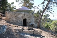
Iqrit was a Palestinian Christian village, located 25 kilometres northeast of Acre, in the western Galilee. In October 1948, the village's Palestinian Arab inhabitants were expelled by Zionist forces during the 1948 Palestine war, and the territory later became part of the new State of Israel. All of its Palestinian Christian inhabitants were forced to flee to Lebanon or the Israeli village of Rameh, and, despite the promise that they would be returned in two weeks' time, the villagers were not allowed to return, and the Israeli army destroyed the village.

<span class="mw-page-title-main">Safsaf</span> Depopulated Palestinian village in present-day Israel

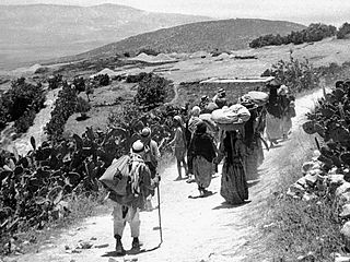
Safsaf was a Palestinian village 9 kilometres northwest of Safed, present-day Israel. Its villagers fled to Lebanon after the Safsaf massacre in October 1948, during the 1948 Arab–Israeli War.

<span class="mw-page-title-main">Ijzim</span> Arab village in Mandatory Palestine

Ijzim was a Palestinian village in the Haifa Subdistrict of British Mandate Palestine, 19.5 kilometers south of Haifa, that was depopulated during the 1948 Arab-Israeli war. Many residents resettled in Jenin after Operation Shoter on 24 July 1948.

<span class="mw-page-title-main">Al-Khalisa</span> Place in Safad, Mandatory Palestine

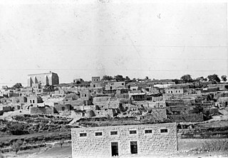
Al-Khalisa was a Palestinian Arab village situated on a low hill on the northwestern edge of the Hula Valley of over 1,800 located 28 kilometers (17 mi) north of Safad. It was depopulated in the 1948 Palestine war.

<span class="mw-page-title-main">Qumya</span> Village in Baysan, Mandatory Palestine

Qumya, was a Palestinian village of 510 inhabitants when it was depopulated prior to the 1948 Arab-Israeli war.

<span class="mw-page-title-main">Sha'ar HaAmakim</span> Kibbutz in northern Israel

Sha'ar HaAmakim is a kibbutz in northern Israel associated with the Hashomer Hatzair movement founded in 1935. Located near Kiryat Tiv'on, it falls under the jurisdiction of Zevulun Regional Council. In 2022 it had a population of 782.

<span class="mw-page-title-main">Kawkab al-Hawa</span> Place in Baysan, Mandatory Palestine

Kawkab al-Hawa, is a depopulated former Palestinian village located 11 km north of Baysan. It was built within the ruins of the Crusader fortress of Belvoir, from which it expanded. The Crusader names for the Frankish settlement at Kawkab al-Hawa were Beauvoir, Belvoir, Bellum videre, Coquet, Cuschet and Coket. During Operation Gideon in 1948, the village was occupied by the Golani Brigade and depopulated.

<span class="mw-page-title-main">Abu Shusha, Haifa</span> Arab village in Haifa subdistrict, Mandatory Palestine

Abu Shusha was a Palestinian Arab village in the Haifa Subdistrict. It was depopulated during the 1947–48 Civil War in Mandatory Palestine on 9 April 1948 during the Battle of Mishmar HaEmek. The village was inhabited by Turkmens.

<span class="mw-page-title-main">Arab al-Fuqara</span> Place in Haifa, Mandatory Palestine

Arab al-Fuqara was a Palestinian Arab village in the Haifa Subdistrict. It was depopulated during the 1947–1948 Civil War in Mandatory Palestine on April 10, 1948. At that time, the land records of the village consisted of a total area of 2,714 dunams, of which 2,513 were owned by Jews, 15 owned by Arabs, and the remaining 186 dunams being public lands.

<span class="mw-page-title-main">Ayn Ghazal (village)</span> Village in Haifa, Mandatory Palestine

Ayn Ghazal was a Palestinian Arab village located 21 kilometers (13 mi) south of Haifa. Depopulated during the 1948 Arab-Israeli War as a result of an Israeli military assault during Operation Shoter, the village was then completely destroyed. Incorporated into the State of Israel, it is now mostly a forested area. The Israeli moshav of Ofer ("fawn") was established in 1950 on part of the former village's lands. Ein Ayala, a moshav established in 1949, lies just adjacent; its name being the Hebrew translation of Ayn Ghazal.

<span class="mw-page-title-main">Al-Butaymat</span> Village in Haifa, Mandatory Palestine

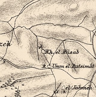
Al-Butaymat was a Palestinian Arab village the Haifa Subdistrict, located 31 kilometers (19 mi) southeast of Haifa. It was depopulated during the 1947–48 Civil War in Mandatory Palestine on May 1, 1948, under the Battle of Mishmar HaEmek.

<span class="mw-page-title-main">Khirbat Al-Dumun</span> Place in Haifa, Mandatory Palestine

Al-Dumun was a Palestinian Arab village in the Haifa Subdistrict. It was depopulated during the 1947–1948 Civil War in Mandatory Palestine on April 30, 1948. It was located 10.5 km southeast of Haifa.

<span class="mw-page-title-main">Kabara, Haifa</span> Village in Haifa, Mandatory Palestine

Kabara was a Palestinian Arab village in the Haifa Subdistrict. It was depopulated during the 1947–1948 Civil War in Mandatory Palestine on April 30, 1948. It was located 30 km southeast of Haifa.

<span class="mw-page-title-main">Khirbat Lid</span> Village in Haifa, Mandatory Palestine

Lid was a Palestinian village in the Haifa Subdistrict. It was depopulated during the 1948 Arab–Israeli War on April 9, 1948. It was 32 km southeast of Haifa.

<span class="mw-page-title-main">Khirbat Sa'sa'</span> Village in Haifa, Mandatory Palestine

Khirbat Sa'sa' was a Palestinian Arab village in the Haifa Subdistrict. It was depopulated during the 1947–1948 Civil War in Mandatory Palestine on April 28, 1948. It was located 15 km east of Haifa.

<span class="mw-page-title-main">Umm az-Zinat</span> Place in Haifa, Mandatory Palestine

Umm az-Zinat was a Palestinian Arab village in the Haifa Subdistrict. It was depopulated during the 1948 War on May 15, 1948, by Golani Brigade's Fourth Battalion. It was located 20.5 km southeast of Haifa.

<span class="mw-page-title-main">Daniyal</span> Village in Ramle, Mandatory Palestine

Daniyal was a Palestinian village in the Ramle Subdistrict that was located 5 km east of Ramla and southeast of Lydda. It was depopulated during the 1948 Arab–Israeli War on July 10, 1948, by the Yiftach Brigade under the first phase of Operation Dani, as part of the broader 1948 Palestinian expulsion and flight and Nakba.

<span class="mw-page-title-main">Al-Jalama, Tulkarm</span> Village in Tulkarm, Mandatory Palestine

Al-Jalama or Khirbat al-Jalama was a Palestinian Arab village 8.5 kilometres (5.3 mi) north of Tulkarm. Situated close to the eastern banks of a valley of the same name, it was inhabited during the Crusader and Mamluk periods, and again in Ottoman period by villagers from nearby Attil.

References

  1. Mülinen, 1908, p.283
  2. 1 2 3 Conder and Kitchener, 1882, SWP, II, p. 42
  3. Sheikh ’Ameir, Sheikh ’Ameir; from personal name, according to Palmer, 1881, p. 152
  4. Sheikh ’Ameir, Sheikh ’Ameir; from personal name, according to Palmer, 1881, p. 152
  5. Palmer, 1881, p. 147
  6. Morris, 2004, p. xviii, village #168. Also gives cause of depopulation
  7. 1 2 3 Government of Palestine, Department of Statistics. Village Statistics, April, 1945. Quoted in Hadawi, 1970, p. 48
  8. 1 2 Government of Palestine, Department of Statistics, 1945, p. 14
  9. 1 2 Khalidi, 1992, pp. 166, 188
  10. Morris, 2004, p. xxii, settlement #120
  11. Josephus, Wars of the Jews (ii.xviii.§1); Life of Josephus, p. 77.
  12. Schürer (1891), §23 (The Hellenistic Towns), pp. 127–128.
  13. Josephus, Antiquities of the Jews (xv.viii.§5); Wars of the Jews (iii.iii.§1); called Geba by Pliny, Natural History (v.19.75). see: Josephus (1927). "The Jewish War". doi:10.4159/DLCL.josephus-jewish_war.1927 . Retrieved 10 August 2016.{{cite journal}}: Cite journal requires |journal= (help)  via  digital Loeb Classical Library (subscription required).
  14. Mazar (1957), p. 19; HUCA xxiv (1952/3), pp. 75–81; Avi-Yonah (1940), p. 38
  15. Cf. Josephus, Vita § 24
  16. Dvorjetski (2009)
  17. al-Bakhīt, Muḥammad ʻAdnān; al-Ḥamūd, Nūfān Rajā (1989). "Daftar mufaṣṣal nāḥiyat Marj Banī ʻĀmir wa-tawābiʻihā wa-lawāḥiqihā allatī kānat fī taṣarruf al-Amīr Ṭarah Bāy sanat 945 ah". www.worldcat.org. Amman: Jordanian University. pp. 1–35. Retrieved 2023-05-15.
  18. Marom, Roy; Marom, Tepper; Adams, Matthew, J (2023). "Lajjun: Forgotten Provincial Capital in Ottoman Palestine". Levant. 55 (2): 218–241. doi:10.1080/00758914.2023.2202484. S2CID   258602184.{{cite journal}}: CS1 maint: multiple names: authors list (link)
  19. Hütteroth and Abdulfattah, 1977, p. 158
  20. According to the estimate of Khalidi, there were 99 persons in the village. Khalidi, 1992, p. 165
  21. Conder and Kitchener, 1882, SWP II, p. 54
  22. 1 2 3 Khalidi, 1992, p. 166
  23. Barron, 1923, Table XI, Sub-district of Haifa, p. 33
  24. Mills, 1932, p. 92
  25. Government of Palestine, Department of Statistics. Village Statistics, April, 1945. Quoted in Hadawi, 1970, p. 90
  26. Government of Palestine, Department of Statistics. Village Statistics, April, 1945. Quoted in Hadawi, 1970, p. 140
  27. "Map of UN Partition Plan". United Nations. Archived from the original on January 24, 2009. Retrieved 2009-02-09.
  28. Morris, 2004, pp. 438
  29. Morris, 2004, p. 96, note #172, logbook entry, IDF, for 9. June.p. 146
  30. Morris, 2004, pp. 438- 439, note #146, p. 457
  31. Morris, 2004, p. 441, note #169, pp. 458- 459 citing the investigating "Central Truce Supervision Board", chaired by US Brigadier General W.E. Riley. This board also found that the IDF assault on the villages had been a violation of the truce.
  32. 1 2 3 Benvenisti, 2000, p. 152.
  33. 1 2 Morris, 2004, p. 439
  34. Morris, 2004, p. 441 notes #170, 171, p. 459

Bibliography