"},"elevation_ft":{"wt":"630"},"coordinates":{"wt":"{{coord|41|41|28|N|81|20|31|W|region:US-OH_type:city|display=inline,title}}"},"postal_code_type":{"wt":"[[ZIP code]]s"},"postal_code":{"wt":"44060-44061"},"area_code":{"wt":"[[Area code 440|440]] 436"},"blank_name":{"wt":"[[Federal Information Processing Standard|FIPS code]]"},"blank_info":{"wt":"39-49056{{cite web|url=https://www.census.gov|publisher=[[United States Census Bureau]]|access-date=January 31, 2008|title=U.S. Census website}}"},"blank1_name":{"wt":"[[Geographic Names Information System|GNIS]] feature ID"},"blank1_info":{"wt":"1086425{{GNIS|1086425}}"},"website":{"wt":"{{URL|cityofmentor.com}}"},"footnotes":{"wt":""}},"i":0}}]}" id="mwBQ">City in Ohio, United States
Mentor, Ohio | |
---|---|
| |
Motto: "The City of Choice" | |
![]() Location in Greater Cleveland | |
Coordinates: 41°41′28″N81°20′31″W / 41.69111°N 81.34194°W | |
Country | United States |
State | Ohio |
County | Lake |
Government | |
• Type | Council-manager |
• Council President | Sean P. Blake (R) [1] [2] |
Area | |
• Total | 27.99 sq mi (72.50 km2) |
• Land | 27.80 sq mi (71.99 km2) |
• Water | 0.20 sq mi (0.51 km2) |
Elevation | 630 ft (190 m) |
Population (2020) | |
• Total | 47,450 |
• Density | 1,707.02/sq mi (659.09/km2) |
Demonym | Mentorite |
Time zone | UTC−5 (Eastern (EST)) |
• Summer (DST) | UTC−4 (EDT) |
ZIP codes | 44060-44061 |
Area code | 440 436 |
FIPS code | 39-49056 [5] |
GNIS feature ID | 1086425 [4] |
Website | cityofmentor |
Mentor ( /ˈmɛntər/ MEN-tər) is the largest city in Lake County, Ohio, United States. The population was 47,450 at the 2020 census. It is part of the Cleveland metro area.
Mentor was first settled in 1797. In 1876, James A. Garfield purchased a home in Mentor, from which he conducted the first successful front porch campaign for the presidency; the house is now maintained as the James A. Garfield National Historic Site. The city is home to Headlands Beach State Park, the longest public swimming beach in Ohio. The city is a major center of retail stores, ranking sixth-largest in Ohio as of 2012 [update] , [6] and restaurants, ranking seventh-largest in the state as of 2012 [update] . [7] Mentor Avenue (US 20) is the major retail center, which includes the Great Lakes Mall, with additional shopping and strip malls found along most major roads. Convenient Food Mart is based in Mentor. Major products include medical related, polymers, plastics, electric boards and other peripherals that generally serve the computer and automation industries. Two major railroads pass through the city, CSX Transportation and Norfolk Southern. Medical equipment company Steris is based in Mentor.
Mentor is named after the Greek figure Mentor, in keeping with the Connecticut Western Reserve settlers' tradition, as well as that of most other Americans at the time, of celebrating aspects of Greek classicism (nearby Solon, Macedonia, Euclid, and Akron also were named using that principle). [8]
The pronunciation of the city's name is a shibboleth, with many residents pronouncing it as "men-ner" and outsiders using the more conventional "men-tore", while in the media and among most residents, "men-ter" is prominent. [9] [10] The city's former slogan, "It's better in Mentor," reflects this fact.
Mentor was formally established in 1855 but founded in the late eighteenth century by Charles Parker who built the first settlement. [11] This settlement was established before Ohio became the 17th state in the Union in 1803. It earned the nickname "Rose Capital of the Nation" due to the abundant rosebushes that grew throughout the city. During the time this nickname developed, Mentor's tourist industry boomed due to Clevelanders trying to escape a dirty, industrial atmosphere. Post World War II, most Mentor dwellers had cars and could efficiently drive to work. This caused an increase in middle and working-class families and by 2000, about 50,000 people lived in Mentor. [12]
The "Official Flag of the City of Mentor" was designed by Brad Frost in 1988 for a contest by Mentor Headlands. The flag's appearance is similar to Ohio's flag in that they have similar shapes, a large blue triangle, and stripes. The blue triangle represents Ohio's hills while the stripes represent roads and waterways. There is a white circle, symbolizing Ohio, with a cardinal, the official bird of Ohio and Mentor, sitting in the middle. There are six stars surrounding the circle symbolizing the 6 original townships, including Mentor, surveyed in 1797. [13]
Mentor is a suburb of Cleveland and is located on the south shore of Lake Erie. The Mentor Headlands area of Mentor, located in the northeast portion of the city, [14] was settled in 1797 by Connecticut Land Company surveyors. [15]
According to the United States Census Bureau, the city has a total area of 28.00 square miles (72.52 km2), of which 26.65 square miles (69.02 km2) is land and 1.35 square miles (3.50 km2) is water. [16]
The average temperature in Mentor is 49.90 °F which is comparable to the Ohio average temperature of 50.88 °F but lower than the national average of 54.45 °F. The annual average for precipitation is 42.87 inches which is higher than the national and state average, Mentor averages 93.4 days with more than .1 inches of rain. This is higher than Ohio's average of 80 days. Mentor expects about 61.25 days with 1 or more inches of snow. The wind average is 18.61 mph and humidity is 75.82%. [17]
Census | Pop. | Note | %± |
---|---|---|---|
1870 | 416 | — | |
1880 | 540 | 29.8% | |
1890 | 502 | −7.0% | |
1900 | 624 | 24.3% | |
1910 | 732 | 17.3% | |
1920 | 851 | 16.3% | |
1930 | 1,589 | 86.7% | |
1940 | 1,827 | 15.0% | |
1950 | 2,383 | 30.4% | |
1960 | 4,354 | 82.7% | |
1970 | 36,912 | 747.8% | |
1980 | 41,903 | 13.5% | |
1990 | 47,358 | 13.0% | |
2000 | 50,278 | 6.2% | |
2010 | 47,159 | −6.2% | |
2020 | 47,450 | 0.6% | |
Sources: [18] [19] [20] [21] [22] [5] |
As of the census [23] of 2010, there were 47,159 people, 19,166 households, and 13,339 families residing in the city. The population density was 1,769.6 inhabitants per square mile (683.2/km2). There were 20,218 housing units at an average density of 758.6 per square mile (292.9/km2). The racial makeup of the city was 96.3% White, 1.0% African American, 0.1% Native American, 1.4% Asian, 0.3% from other races, and 1.0% from two or more races. Hispanic or Latino of any race were 1.3% of the population.
There were 19,166 households, of which 28.8% had children under the age of 18 living with them, 56.4% were married couples living together, 9.4% had a female householder with no husband present, 3.8% had a male householder with no wife present, and 30.4% were non-families. 25.7% of all households were made up of individuals, and 11.1% had someone living alone who was 65 years of age or older. The average household size was 2.44 and the average family size was 2.94.
The median age in the city was 44.8 years. 21.2% of residents were under the age of 18; 6.9% were between the ages of 18 and 24; 22.3% were from 25 to 44; 33.2% were from 45 to 64; and 16.5% were 65 years of age or older. The gender makeup of the city was 48.4% male and 51.6% female.
As of the census [5] of 2000, there were 50,278 people, 18,797 households, and 14,229 families residing in the city. The population density was 1,878.2 inhabitants per square mile (725.2/km2). There were 19,301 housing units at an average density of 721.0 per square mile (278.4/km2). The racial makeup of the city was 97.30% White, 0.64% African American, 0.05% Native American, 1.19% Asian, 0.03% Pacific Islander, 0.18% from other races, and 0.61% from two or more races. Hispanic or Latino of any race were 0.72% of the population. 19.8% were of German, 15.1% Italian, 13.1% Irish, 8.8% English, 6.5% Polish, 5.5% Slovene and 5.4% American ancestry according to Census 2000.
There were 18,797 households, out of which 35.8% had children under the age of 18 living with them, 63.6% were married couples living together, 8.9% had a female householder with no husband present, and 24.3% were non-families. 20.5% of all households were made up of individuals, and 8.1% had someone living alone who was 65 years of age or older. The average household size was 2.65 and the average family size was 3.08.
In the city the population was spread out, with 25.9% under the age of 18, 6.5% from 18 to 24, 29.0% from 25 to 44, 26.3% from 45 to 64, and 12.3% who were 65 years of age or older. The median age was 39 years. For every 100 females, there were 94.2 males. For every 100 females age 18 and over, there were 91.5 males.
The median income for a household in the city was $57,230, and the median income for a family was $65,322. Males had a median income of $44,021 versus $31,025 for females. The per capita income for the city was $24,592. About 1.8% of families and 2.7% of the population were below the poverty line, including 2.8% of those under age 18 and 4.4% of those age 65 or over.
Mentor has a council-manager system of government. The City Council consists of seven members, who are elected for four-year terms. Three members are elected by the city at-large, and four members are elected from wards. As of 2024, the members of the City Council are as follows: [24]
Seat | Name | Party |
---|---|---|
Council-at-Large | Janet Dowling | Republican |
Council-at-Large | Scott Marn | Republican |
Council-at-Large | Ray Kirchner | Independent |
Ward 1 | Sean Blake | Republican |
Ward 2 | Matthew Donovan | Democrat |
Ward 3 | Mark Freeman | Republican |
Ward 4 | John Krueger | Republican |
Mentor Exempted Village School District operates the public schools in the community. Mentor's school system consists of eight elementary schools, two middle schools, and Mentor High School. Like many school systems in Ohio, Mentor Schools suffered a financial crisis in the early 2000s, but passed a large levy and is now largely on solid footing. [25] It is one of the fastest Ohio school systems ever to emerge from fiscal emergency. [26] The financial difficulties were due in part to years of accounting fraud. [27] [ failed verification ]
Elementary schools:
Middle schools:
High school:
Special needs schools:
Many bike paths have been built in Mentor in recent years. [11] The parks in the city include: [31]
In 2016, Mentor's rate of 1.1 violent crimes per 1,000 residents was equal to the average (median) among Ohio cities. However, its rate of 22.1 property crimes per 1,000 residents was higher than the state median of 18.3 per 1,000 people. The property crime rate was high primarily due to the incidence of theft (larceny) in the city. [32]
In 2014, Garden Thieves Pictures released Mentor, a documentary directed by Alix Lambert about a series of four student suicides beginning in 2010 at Mentor High School that have been attributed to bullying and harassment at the school. Lambert received ten violent threats after the release of the film's trailer. [33] The Boston Globe wrote about the documentary, saying "This is a problem of not just one town, but of the entire culture of conformity. It’s much bigger than just one bad kid or bad teacher. In my films I'm interested in looking at the whole problem rather than the easy answers." [34] The Daily Beast called Mentor High School "Suicide High." [35]
Primarily receiving the Cleveland-area television market, Mentor residents (being so much further east of Cleveland) can also receive Youngstown-area television reception from WFMJ-TV with a good antenna. [36] This allowed access to NBC programming pre-empted by KYW-TV from 1956 until 1965, when Cleveland's channel 3 was owned by Westinghouse Broadcasting, before the sale was undone and it returned to NBC ownership as WKYC. [37]
Mentor is served by Laketran, which provides bus service throughout Lake County, as well as by Willoughby's Lake County Executive Airport, whose runways enter Mentor. Interstate 90, US Route 20, and State Route 2 all traverse the city.
Lake County is a county in the U.S. state of Ohio. As of the 2020 census, the population was 232,603. Its county seat is Painesville, and its largest city is Mentor.
Geneva is a city in northwestern Ashtabula County, Ohio, United States. The population was 5,924 at the 2020 census. It is part of the Cleveland metropolitan area, 44 miles (71 km) northeast of Cleveland. The area which would become Geneva was originally settled in 1805, and was incorporated as a city in 1958. It is named after Geneva, New York.
Bay Village is a city in western Cuyahoga County, Ohio, United States. Located along the southern shore of Lake Erie, the city is a western suburb of Cleveland and a part of the Cleveland metropolitan area. The population was 16,163 at the 2020 census.
Brook Park is a city in Cuyahoga County, Ohio, United States and a suburb of Cleveland. As of the 2020 census, the population was 18,595.
Cleveland Heights is a city in Cuyahoga County, Ohio, United States. The population was 45,312 at the 2020 census. One of Cleveland's historic streetcar suburbs, it was founded as a village in 1903 and a city in 1921.
East Cleveland is a city in Cuyahoga County, Ohio, United States. The population was 13,792 at the 2020 census. It is a suburb lying east and south of Cleveland and west of Cleveland Heights.
Garfield Heights is a city in Cuyahoga County, Ohio, United States. The population was 29,781 at the time of the 2020 census. A suburb of Cleveland, it is a part of the Cleveland metropolitan area.
Chardon is a city in and the county seat of Geauga County, Ohio, United States. The population was 5,242 at the 2020 census. It is the only incorporated city in Geauga County, and includes land that was once part of Chardon, Hambden and Munson townships. It is located about 10 miles south of Lake Erie and within the "snow belt" of the Great Lakes and is part of the Cleveland metropolitan area.
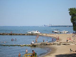
Eastlake is a city in Lake County, Ohio, United States. It takes its name from its location northeast of Cleveland, following along the shore of Lake Erie. The population was 17,670 at the 2020 census. The 2003 North America blackout stemmed from an Eastlake generating station going offline.
Kirtland Hills is a village in Lake County, Ohio, United States and a rural suburb of Cleveland. The population was 692 at the 2020 census.
Mentor-on-the-Lake is a city in Lake County, Ohio, United States. The population was 7,131 at the 2020 census.
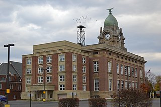
Painesville is a city in and the county seat of Lake County, Ohio, United States, located along the Grand River. It is a northeast suburb of Cleveland. Its population was 20,312 at the 2020 census. Painesville is included in the Greater Cleveland metropolitan area.
Willoughby is a city in Lake County, Ohio, United States, along the Chagrin River. The population was 23,959 at the time of the 2020 census. A suburb of Cleveland, it is part of the Cleveland metropolitan area.
Avon Lake is a city in northeastern Lorain County, Ohio, United States, located on the southern shore of Lake Erie about 17 miles (27 km) west of Cleveland. The population was 25,206 at the 2020 census. It is part of the Cleveland metropolitan area.
North Ridgeville is a city located along the eastern border of Lorain County, Ohio, United States. The city's population was 35,280 as of the 2020 census. A part of the Cleveland metropolitan area, North Ridgeville is the fastest-growing city in northern Ohio. It has been ranked the 13th safest city in the United States and the safest in Ohio.
Medina is a city in and the county seat of Medina County, Ohio, United States. The population was 26,094 at the 2020 census. It lies about 33 miles (53 km) south of Cleveland and 23 miles (37 km) west of Akron within the Cleveland metropolitan area.
Centerville is a city in Montgomery County, Ohio, United States. A core suburb of Metro Dayton, its population was 24,240 as of the 2020 census.
Aurora is a city in northwestern Portage County, Ohio, United States. A suburb in between Akron and Cleveland, the population was 17,239 at the 2020 census. It is part of the Akron metropolitan area.
Streetsboro is a city in western Portage County, Ohio, United States. The population was 17,260 at the 2020 census. It is part of the Akron metropolitan area. The city was formed from the former Streetsboro Township of the Connecticut Western Reserve.
Pickerington is a city in Fairfield and Franklin counties in the central region of the U.S. state of Ohio. It is a suburb of Columbus. The population was 23,094 at the 2020 census. It was founded in 1815 as Jacksonville, named after Andrew Jackson. The name was changed in 1827 in honor of its founder, Abraham Pickering. As land annexation, development, and immigration into the Columbus area continues, the city of Pickerington has generally followed suit. Pickerington is home to the Motorcycle Hall of Fame, located off of Interstate 70.