
Bandar Utama Damansara is a residential township located within the Sungai Buloh mukim (subdivision) of the Petaling District, Selangor, Malaysia. It is a residential suburb and home to the popular 1 Utama Shopping Centre. Bandar Utama Damansara, together with neighbouring Kampung Sungai Kayu Ara, form the PJU 6 section of the city of Petaling Jaya.
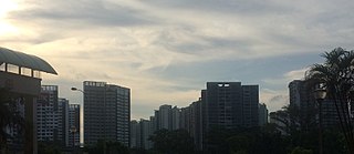
Woodlands is a planning area and residential town located in the North Region of Singapore. As of 2019, the town has a population of 254,733. Located approximately 25 km north of the central business district (CBD), it is the densest planning area and the regional centre for the northern parts of the country.

Tharamani is an area in the south Indian city of Chennai. It is known for the presence of the city's first IT parks and numerous government educational and research institutions. It is located adjacent to the posh residential area of Adyar and Besant Nagar in South Chennai. It is an Estate with Express IT Companies, making it a massive located neighbourhood in the IT Expressway.
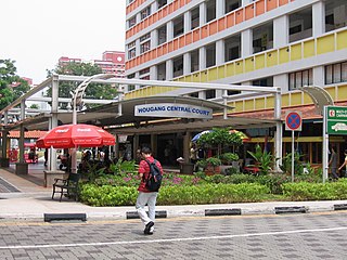
Hougang is a planning area and mature residential town located in the North-East Region of Singapore. It is the largest housing estate in Singapore based on land area, and is home to 247,528 residents as of 2018. Hougang planning area is bordered by Sengkang to the north, Geylang to the south, Bedok to the southeast, Toa Payoh to the southwest, Serangoon to the west and Paya Lebar to the east.
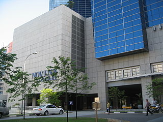
Novena is a planning area located within the Central Region of Singapore. Novena is bounded by Toa Payoh to the north, Bukit Timah to the west, Tanglin to the south and Kallang to the east. It constitutes of five subzones, namely Balestier, Dunearn, Malcolm, Mount Pleasant and Moulmein.
Thiruvanmiyur is a largely residential neighborhood in the south of Chennai, Tamil Nadu, India. Thiruvanmiyur witnessed a spike in its economy with the construction of Chennai's first dedicated technology office space, the Tidel Information Technology Park in neighboring Taramani. The subsequent rise of several information technology businesses, research centres and offices around Tidel park proved fortuitous for Thiruvanmiyur, as many of the workers at these offices often made Thiruvanmiyur their home. The Marundeeswarar Temple, dedicated to Shiva previously defined the area, leading it to be mentioned in Sangam Tamil epics. It is also commonly referred to as the MICO layout of Chennai city. Other Famous Temples are Ashtalakshmi Temple and Aarupadai Murugan Temple.
Velachery is a neighborhood of Chennai. It is located in the southern part of the Chennai city sharing borders with Guindy in the north, Taramani in the east, Perungudi in the south-east, Pallikaranai in the south, Madipakkam in south-west, Adambakkam in the west and north-west. It is the headquarters of Velachery taluk and straddles the boundary between Chennai and Kancheepuram districts.

Kelambakkam is a suburban and residential neighbourhood of Chennai, India. It is located in the south-eastern portion of the city along the Old Mahabalipuram Road (OMR), and is about 5 km from Siruseri IT park and 12 km from Sholinganallur junction. It is another important junction after Sholinganalur, which connects GST road (Vandalur) and ECR road (Kovalam). Kelambakkam is considered as the Southern Gateway to Chennai city on OMR Road and comes under Zone-2 of OMR Road.
Fernvale is a neighbourhood of Sengkang New Town in Singapore. It is located between Sungei Punggol and the proposed Sengkang West Industrial Estate. The house numbers of the public apartment blocks in Fernvale begin with the number '4' (4xx). Fernvale is the newest neighbourhood in Sengkang Town to be completed by the Housing and Development Board (HDB). Seletar Mall, a new shopping amenity which houses Sengkang's first cineplex, is located within this neighbourhood. In 2017, a proposed community facility to be located next to Seletar Mall was announced, which houses a community club, childcare centre, hawker centre and wet market. The community facility which was slated to be ready by the second half of 2020, had stopped construction in April 2020 due to the COVID-19 measures set by the government. Construction of the facility has since continued in the second half of 2020 and was completed in 2022.
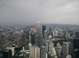
Kuala Lumpur City Centre (KLCC) is a multipurpose development area in Kuala Lumpur, Malaysia. KLCC refers to the area within and surrounding the KLCC Park but the term has also been widely used by buildings nearby to the vicinity.

Pallikaranai is a neighborhood and a residential area in south Chennai, Tamil Nadu, India. Located in proximity to the IT industry in Old Mahabalipuram Road, Chennai's central business districts and the automobile hub in GST road has attracted more population to Pallikaranai in the 2000s. Pallikaranai became a part of the Chennai Corporation in July 2011.
Sholinganallur, also spelled Solinganalloor or Sozhinganalloor, is a southern suburb of Chennai, India.
Thoraipakkam also spelt Thuraipakkam, also known as Okkiyam Thuraipakkam or Oggiyamduraipakkam, is an area of Chennai, India. It is one of the stops on what is called as the IT expressway, on Old Mahabalipuram Road, now known as Rajiv Gandhi Salai, the first six lane road in Chennai. Okkiyam Thoraipakkam is on the eastern banks of the Pallikaranai marsh which has been designated as a reserve forest area and is one of the few remaining significant natural ecosystems within Chennai. Thoraipakkam is 3 km in length, starting from Perungudi to its north. It is located exactly in the middle of the OMR Road.
Karapakkam is an area of Chennai, in Tamil Nadu, India. It is one of the stops on the Old Mahabalipuram Road, or commonly referred to as OMR. It is situated between the IT Hubs of Thoraipakkam and Sholinganallur. It is parallel to Injambakkam on the ECR Highway.
Pinang is a town and an administrative district (kecamatan) of Tangerang City, in Banten Province of Indonesia, on the island of Java. The district covers an area of 21.59 km2, and had a population of 160,206 at the 2010 Census and 180,131 at the 2020 Census; the official estimate as at mid 2023 was 186,671.
Nolambur is the neighbourhood in the western part of Chennai. It is near to the Poonamallee High Road near Maduravoyal, Mogappair West, Ambattur, Ayanambakkam, and Athipet.
Navalur is a south suburb of Chennai, India and located just 5 km from Sholinganalur junction along Old Mahabalipuram Road. Navalur is located between Sholinganallur and Kelambakkam and comes under Thiruporur taluk of Chengalpattu district. This area was once a village but with the advent of IT Companies and the rapid development of the Old Mahabalipuram Road, it has become a bustling and most demanded location in Chennai. Proximity to employment opportunities, good asset appreciation, outstanding road Infrastructure, proximity to beaches at ECR and other entertainment venues continues to attract more residents to this suburb.

The Bandar Utama station is a mass rapid transit (MRT) station serving the suburb of Bandar Utama in Petaling Jaya, Selangor, Malaysia as well as parts of Taman Tun Dr Ismail, Kuala Lumpur which lie across the Damansara–Puchong Expressway from the station.

Puri Indah is a growing neighborhood at Kembangan, Jakarta, Indonesia. The area is in between South Kembangan and North Meruya administrative village of Kembangan district of West Jakarta. The area is located at the intersection of W1-W2 toll/expressway of the Jakarta Outer Ring Road.
