Cecil Plains is a rural town and locality in the Toowoomba Region, Queensland, Australia. In the 2021 census, the locality of Cecil Plains had a population of 380 people.

Pilton is a rural town and locality in the Toowoomba Region, Queensland, Australia. It is south of the city of Toowoomba. In the 2021 census, the locality of Pilton had a population of 71 people.
Hodgson Vale is a rural locality in the Toowoomba Region, Queensland, Australia. In the 2021 census, Hodgson Vale had a population of 1,444 people.
Yandilla is a rural locality in the Toowoomba Region, Queensland, Australia. In the 2021 census, Yandilla had a population of 50 people.

Ascot is a rural locality in the Toowoomba Region, Queensland, Australia. In the 2021 census, Ascot had a population of 106 people.

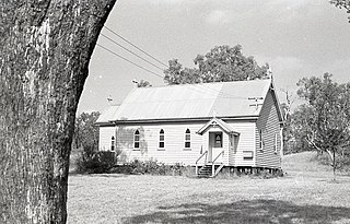
Felton is a rural locality in the Toowoomba Region, Queensland, Australia. In the 2021 census, Felton had a population of 267 people.
Stonehenge is a rural locality in the Toowoomba Region, Queensland, Australia. In the 2021 census, Stonehenge had a population of 20 people.
Brush Creek is a rural locality in the Goondiwindi Region, Queensland, Australia. In the 2021 census, Brush Creek had a population of 39 people.
Canning Creek is a rural locality split between the Goondiwindi Region and the Toowoomba Region in Queensland, Australia. In the 2021 census, Canning Creek had a population of 21 people.
Devon Park is a rural locality in the Toowoomba Region, Queensland, Australia. In the 2021 census, Devon Park had a population of 55 people.
North Branch is a locality in the Toowoomba Region, Queensland, Australia. In the 2021 census, North Branch had a population of 48 people.
Rangemore is a rural locality in the Toowoomba Region, Queensland, Australia. In the 2021 census, Rangemore had "no people or a very low population".
St Ruth is a locality split between the Western Downs Region and the Toowoomba Region in Queensland, Australia. In the 2021 census, St Ruth had a population of 165 people.
Irvingdale is a locality split between the Toowoomba Region and the Western Downs Region, both in Queensland, Australia. In the 2021 census, Irvingdale had a population of 163 people.
Kolonga is a rural locality in the Bundaberg Region, Queensland, Australia. In the 2021 census, Kolonga had a population of 33 people.
Rosenthal Heights is a mixed-use locality in the Southern Downs Region, Queensland, Australia. In the 2021 census, Rosenthal Heights had a population of 2,664 people.
Felton South is a rural locality in the Toowoomba Region, Queensland, Australia. In the 2021 census, Felton South had a population of 78 people.
Dunmore is a rural locality in the Toowoomba Region, Queensland, Australia. In the 2021 census, Dunmore had a population of 39 people.
Rosalie Plains is a rural locality in the Toowoomba Region, Queensland, Australia. In the 2021 census, Rosalie Plains had a population of 54 people.
Emu Creek is a rural locality in the Toowoomba Region, Queensland, Australia. In the 2021 census, Emu Creek had a population of 113 people.
