Amur annexations

Last updated
Changes in the Russo-Chinese border in the 17th-19th centuries. MANCHURIA-U.S.S.R BOUNDARY Ct002999.jpg
Changes in the Russo-Chinese border in the 17th–19th centuries.

In 1858 and 1860, the Russian Empire twice annexed territories adjoining the Amur River through unequal treaties forced upon the Chinese Qing dynasty. The 1858 Treaty of Aigun ceded Priamurye to Russia, a territory stretching from the Amur River in the south to the Stanovoy Mountains in the north. Two years later, the Second Opium War concluded with the Convention of Peking, resulting in the Russians also annexing Primorye, a territory that included the entire Pacific coast down to the Korean border, as well as the island of Sakhalin. These territories roughly correspond to modern-day Amur Oblast and Primorsky Krai, respectively. Collectively, they are often referred to as Outer Manchuria, part of the greater region of Manchuria. [1]

Contents

Background

Hydrologically, the Stanovoy Range separates the rivers that flow north into the Arctic from those that flow south into the Amur River. Ecologically, the area is the southeastern edge of the Siberian boreal forest with some areas good for agriculture along the middle Amur. Socially and politically, from about 600 CE, it was the northern fringe of the Chinese-Korean-Manchu world. [2]

In 1643, Russian adventurers spilled over the Stanovoys. By 1689, they were driven back by the Manchus. By the Treaty of Nerchinsk (1689) the two empires recognized the Stanovoys and the Argun River as their border. This remained stable until the 1840s. [2]

Following the voyages of Captain James Cook, significant numbers of British, French, and American vessels began entering the Pacific. They were followed by Russians like Grigory Shelikhov and Nikolai Rezanov who were mainly concerned with the new Russian colonies in Alaska. This raised the problem of naval defense of the east coast of Siberia and the possibility of using the Amur River as a supply route to the Pacific. [2]

Muravyov and the Treaty of Aigun (1858)

The Qing Empire circa 1820. Qing Empire circa 1820 EN.svg
The Qing Empire circa 1820.
An 1851 British map showing the Russo-Chinese border before the annexation. John-Tallis-1851-Tibet-Mongolia-and-Manchuria-NE.jpg
An 1851 British map showing the Russo-Chinese border before the annexation.

In 1845, Alexander von Middendorf entered the Amur country and wrote a report. In 1847, Aleksandr Gavrilov  [ ru ] reached the mouth of the Amur but could not find a deep-water entrance. [3]

In 1847, Nikolay Muravyov was appointed governor-general of East Siberia. Before leaving for Irkutsk, he arranged for the creation of an Amur Committee to coordinate work in the area. In 1849, he made an overland trip to Okhotsk and then to Petropavlovsk-Kamchatsky. One result of this was the removal of the main naval center from Okhotsk to Petropavlovsk. [4]

In 1848, Gennady Nevelskoy was sent in the Baikal to explore the Pacific coast.[ citation needed ]

In 1849, Nevelskoy sailed part way up the Amur, and then sailed south through the Tatar Strait, thereby proving that Sakhalin was an island, a fact that was kept a military secret.[ citation needed ]

In 1850, Nevelskoy founded Nikolayevsk-on-Amur on what was alleged Chinese territory. Karl Nesselrode, the foreign minister, tried to overrule this, but Nicholas I declared "where once the Russian flag is raised, it must not be lowered".[ citation needed ] Over the next three years, Nevelskoy established other forts on the alleged Chinese territory around the mouth of the Amur.[ citation needed ]

To establish a military force, Muravyov created a new Cossack host, the Transbaikalian Cossacks, by arming 20,000 mining serfs. In May–June 1854 he and 1,000 men sailed down the Amur to Nikolayevsk. The Manchu governor at Aigun had no choice but to let them pass. [4]

News of the Crimean War reached the far east in July 1854. In September, an Anglo-French naval force was defeated at the Siege of Petropavlovsk. Judging that Petropavlovsk could not be defended, Muravyov ordered Rear Admiral Vasily Zavoyko to move his forces to the Amur area. In May 1855, Charles Elliot's force found Zavoyko at De Kastri Bay (south of Cape Nevelskoy on the Tatar Strait).[ citation needed ]

Under the cover of fog, Zavoiko withdrew north to the mouth of the Amur, which baffled the British since they thought that Sakhalin was connected to the mainland. In 1855, Muravyov sent a 3,000-man force down the Amur, including settlers. The Chinese declared this to be illegal, but did nothing.[ citation needed ]

Also in 1855, Russia and Japan signed the Treaty of Shimoda which temporarily resolved their conflict in Sakhalin and the Kuril Islands. The Russian representative was Admiral Putyatin (see below).[ citation needed ]

The Second Opium War broke out in 1856. In 1858, the British and French captured Canton. When news of this reached Saint Petersburg, the foreign minister, Alexander Gorchakov, who had replaced Nesselrode, decided that it was time to "activate Russian Far Eastern Policy". Muravyov was given plenipotentiary powers and Admiral Yevfimy Putyatin was sent to Beijing to negotiate a more favorable relation. [4]

In 1856 and 1857, Muravyov sent more settlers down the Amur. In 1858, he went himself. His instructions were not to use force except to rescue captives. On reaching Aigun he presented the local governor with a treaty, which was signed. The Treaty of Aigun assigned all the land north of the Amur to Russia and declared the area east of the Ussuri River and south of the Amur (northern Primorye) to be a Russo-Chinese condominium until further negotiations. [4] The Qing government initially refused to ratify the Treaty of Aigun and considered the treaty invalid, but the Russian gains under the Treaty of Aigun was affirmed as part of the 1860 Sino-Russian Convention of Peking. [5]

Muravyov continued down the Amur and founded Khabarovsk at the mouth of the Ussuri. In September 1858, Alexander II promoted him to full general and granted him the suffix '-Amursky'. In 1859, he sent an exploring expedition down the coast as far as Vladivostok. [6]

Putyatin, Ignatyev, and the Convention of Peking (1860)

Meanwhile, Admiral Yevfimy Putyatin was travelling overland to China. Reaching Kyakhta, he was refused entry in the spring of 1857. He sailed down the Amur and took his ship to Tientsin. Refused entry again, he joined the British and French at Shanghai. When the allies took the Taku Forts Putyatin offered himself as a mediator. The result was the Treaties of Tientsin which granted most of the allied demands. Without fully informing the allies, Putyatin made a separate deal with the Chinese on June 13, 1858. [7]

In return for cannon, 20,000 rifles and military instructors, the frontier would be adjusted in some unspecified way. Putyatin was not aware of the Treaty of Aigun which had been signed 16 days earlier. After the allies withdrew the Chinese failed to implement the treaties. The allies returned in June 1859, attempted to retake the Taku Forts and failed. As a result, the Chinese refused to ratify the treaties. [7]

At this point, a 27-year-old Major General named Nikolay Pavlovich Ignatyev entered the picture. In March 1859 he was assigned to accompany the Russian weapons and instructors. At the frontier he found that the Chinese had rejected the treaties and would not accept the weapons. He continued to Beijing where he stayed at the Russian ecclesiastical mission and attempted to negotiate with the Manchus. [8]

Hearing of allied preparations, Ignatyev joined the British and French in Shanghai and proved to be helpful to the allied councils, as he had a map of Beijing and good interpreters. By October 1860 the British and French had retaken the Taku forts. They entered Beijing and the Emperor fled to Rehe. Ignatyev placed himself as an intermediary between the Europeans and Chinese. In the first two Treaties of Peking (October 24 and 25, 1860) nearly all the allied demands were met. Ignatyev continued negotiations for a Russo-Chinese treaty. He convinced the Chinese that only his support would cause the allies to leave the capital. [8]

The result was the Russo-Chinese Convention of Peking of November 14, 1860. By this, the Treaty of Tientsin was ratified and all the land north of the Amur and east of the Ussuri was ceded to the Russian Empire. Thus, by pure diplomacy and only a few thousand troops, the Russians took advantage of Chinese weakness and the strength of the other European powers to annex 350,000 square miles (910,000 km2) of Chinese territory. With the exception of Muravyov's rather ceremonial cannonade at Aigun, they had apparently not fired a single shot. [8]

See also

Related Research Articles

<span class="mw-page-title-main">Amur</span> Major river in eastern Russia and northeastern China

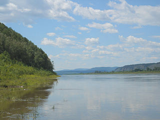
The Amur, or Heilong Jiang, is the world's tenth longest river, forming the border between the Russian Far East and Manchuria/Northeastern China. The Amur proper is 2,824 kilometres (1,755 mi) long, and has a drainage basin of 1,855,000 km2 (716,000 sq mi). Including its source river Argun, it is 4,444 km (2,761 mi) long. The largest fish species in the Amur is the kaluga, attaining a length as great as 5.6 metres (18 ft). The river basin is home to a variety of large predatory fish such as northern snakehead, Amur pike, taimen, Amur catfish, predatory carp and yellowcheek, as well as the northernmost populations of the Amur softshell turtle and Indian lotus.

<span class="mw-page-title-main">Khabarovsk Krai</span> First-level administrative division of Russia

Khabarovsk Krai is a federal subject of Russia. It is located in the Russian Far East and is administratively part of the Far Eastern Federal District. The administrative centre of the krai is the city of Khabarovsk, which is home to roughly half of the krai's population and the largest city in the Russian Far East. Khabarovsk Krai is the fourth-largest federal subject by area, and had a population of 1,343,869 as of 2010.

<span class="mw-page-title-main">Russian Far East</span> Geographical region

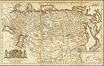
The Russian Far East is a region in Northeast Asia. It is the easternmost part of Russia and the Asian continent; and is administered as a part of the Far Eastern Federal District, which is located between Lake Baikal in eastern Siberia and the Pacific Ocean. The area's largest city is Khabarovsk, followed by Vladivostok. The region shares land borders with the countries of Mongolia, China, and North Korea to its south, as well as maritime boundaries with Japan to its southeast, and with the United States along the Bering Strait to its northeast.

<span class="mw-page-title-main">Convention of Peking</span> 1860 unequal treaty between Qing China and Britain, France, and Russia

The Convention of Peking or First Convention of Peking is an agreement comprising three distinct treaties concluded between the Qing dynasty of China and Great Britain, France, and the Russian Empire in 1860. In China, they are regarded as among the unequal treaties.

<span class="mw-page-title-main">Xianfeng Emperor</span> Emperor of China from 1850 to 1861

The Xianfeng Emperor, also known by his temple name Emperor Wenzong of Qing, personal name Yizhu, was the eighth emperor of the Qing dynasty, and the seventh Qing emperor to rule over China proper, reigned from 1850 to 1861. During his reign, the Qing dynasty experienced several wars and rebellions including the Taiping Rebellion, Nian Rebellion, and Second Opium War. He was the last Chinese emperor to exercise sole power.

<span class="mw-page-title-main">Treaty of Aigun</span> 1858 treaty between Russia and China

The Treaty of Aigun was an 1858 treaty between the Russian Empire and the Qing dynasty that established much of the modern border between the Russian Far East and China by ceding much of Manchuria, now known as Northeast China. Negotiations began after China was threatened with war on a second front by Governor-General of the Far East Nikolay Muraviev when China was suppressing the Taiping Rebellion. It reversed the Treaty of Nerchinsk (1689) by transferring the land between the Stanovoy Range and the Amur River from the Qing dynasty to the Russian Empire. Russia received over 600,000 square kilometers (231,660 sq mi) of what became known as Outer Manchuria.

<span class="mw-page-title-main">Treaty of Nerchinsk</span> 1689 border treaty between Russia and Qing China

The Treaty of Nerchinsk of 1689 was the first treaty between the Tsardom of Russia and the Qing dynasty of China. The Russians gave up the area north of the Amur River as far as the Stanovoy Range and kept the area between the Argun River and Lake Baikal. This border along the Argun River and Stanovoy Range lasted until the Amur Annexation via the Treaty of Aigun in 1858 and the Convention of Peking in 1860. It opened markets for Russian goods in China, and gave Russians access to Chinese supplies and luxuries.

<span class="mw-page-title-main">Aigun</span> Town in Heilongjiang, China

<span class="mw-page-title-main">Outer Manchuria</span> Geopolitical designation in Northeast Asia

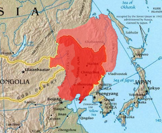
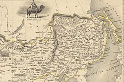
Outer Manchuria, sometimes called Russian Manchuria, refers to a region in Northeast Asia that is now part of the Russian Far East but historically formed part of Manchuria. While Manchuria now more normatively refers to Northeast China, it originally included areas consisting of Priamurye between the Amur River and the Stanovoy Range to the north, and Primorskaya which covered the area in the right bank of Ussuri River to the Pacific Coast. The region was ruled by a series of Chinese dynasties and the Mongol Empire, but control of the area was ceded to the Russian Empire by the Qing China during the Amur annexations in the 1858 Treaty of Aigun and 1860 Treaty of Peking, with the terms "Outer Manchuria" and "Russian Manchuria" arising after the Russian annexation. The same general area became known as Green Ukraine after a large number of settlers from Ukraine came to the region.

<span class="mw-page-title-main">Green Ukraine</span> Historical Ukrainian name for land in the southern Russian Far East

Green Ukraine, also known as Zelenyi Klyn or Zakytaishchyna, is a historical Ukrainian name for the land in the Russian Far East area between the Amur River and the Pacific Ocean, an area roughly corresponding to Outer Manchuria.

<span class="mw-page-title-main">Stanovoy Range</span> Mountain range in Sakha Republic, Russia

The Stanovoy Range is a mountain range located in the Sakha Republic and Amur Oblast, Far Eastern Federal District. It is also known as Sükebayatur and Sükhbaatar in Mongolian, or the Stanovoy Mountains or Outer Khingan Range in English. The range was first studied and scientifically described by Russian researcher Alexander von Middendorff.

Ussuri krai is an unofficial name for a part of Primorsky Krai and Khabarovsky Krai that consisted of the Ussuri and South-Ussuri Okrugs. The name was often used in the late Russian Empire. The name comes from the fact that Ussuri River is located on the territory of the krai.

<span class="mw-page-title-main">Primorskaya Oblast</span> Past Russian administrative division

Primorskaya Oblast was an administrative division of the Russian Empire and the early Russian SFSR, created on October 31, 1856 by the Governing Senate. The name of the region literally means "Maritime" or "Coastal." The region was established upon a Russian conquest of Daur people that used to live along Amur River. Before the Russian conquest of Russian Manchuria, the territory belonged to the Chinese region of Manchuria.

<span class="mw-page-title-main">Nikolay Muravyov-Amursky</span> Russian general, statesman, and diplomat (1809–1881)

Count Nikolay Nikolayevich Muravyov-Amursky was a Russian general, statesman and diplomat, who played a major role in the expansion of the Russian Empire into the Amur River basin and to the shores of the Sea of Japan.

Yishan, courtesy name Jingxuan, was a Manchu lesser noble and official of the Qing dynasty. He is best known for his failure to defend Guangzhou (Canton) from British forces during the First Opium War, and for signing the treaties of Kulja and Aigun with the Russian Empire in 1851 and 1858 respectively.

<span class="mw-page-title-main">Sino-Russian border conflicts</span> Series of conflicts between China and Russia

The Sino-Russian border conflicts (1652–1689) were a series of intermittent skirmishes between the Qing dynasty of China, with assistance from the Joseon dynasty of Korea, and the Tsardom of Russia by the Cossacks in which the latter tried and failed to gain the land north of the Amur River with disputes over the Amur region. The hostilities culminated in the Qing siege of the Cossack fort of Albazin in 1686 and resulted in the Treaty of Nerchinsk in 1689 which gave the land to China.

<span class="mw-page-title-main">Muravyov-Amursky Peninsula</span>

The Muravyov-Amursky Peninsula is a peninsula in Primorsky Krai, Russia, located in the Peter the Great Gulf of the Sea of Japan. Vladivostok, the administrative center of Primorsky Krai, is located on the southern tip of the peninsula.

<span class="mw-page-title-main">Russia in the Opium Wars</span>

Imperial Russia was a participant of the Chinese Opium Wars, more specifically in the second and third wars which occurred in 1856-1860. Russia played a role of mediator, being both an ally with Britain, France, and the United States and negotiator with the elites of the Qing dynasty. Throughout the whole war period Russia provided minimal amount of military aid and used diplomatic power to present its interests in the conflict. As a result of the ratified agreements in 1860 Russia received former Manchurian lands along the Ussuri river and increased its economical influence on China.

Events from the year 1858 in China.

<span class="mw-page-title-main">Amur Oblast (Russian Empire)</span> Subdivision of the Russian Empire

The Amur Oblast with the center in Blagoveshchensk was formed on December 20, 1858 by the Personal Decree No. 33862. By this Decree, on the proposal of the Governor–General of Eastern Siberia and the Siberian Committee, the Amur Region was made up of lands "located on the left bank of the Amur River, starting from the junction of the Shilka and Argun Rivers or from the borders of the Trans–Baikal and Yakutsk Oblasts, along the entire course of the Amur, to the mouth of the river Ussuri and to the new border of the Primorsky Oblast".

References

  1. G. Patrick March, Eastern Destiny: Russia in Asia and the North Pacific (Greenwood, 1996).
  2. 1 2 3 R. A. Pierce, Eastward to Empire: Exploration and Conquest on the Russian Open Frontier, to 1750 (Montreal, 1973).
  3. James R. Gibson, "Russia on the Pacific: the role of the Amur." Canadian Geographer/Le Géographe canadien 12.1 (1968): 15-27.
  4. 1 2 3 4 Rosemary K. I. Quested, The Expansion of Russia in East Asia, 1857-1860 (1968)
  5. Elleman, Bruce (2019). International Rivalry and Secret Diplomacy in East Asia, 1896-1950. Taylor & Francis. p. 19. ISBN   9781317328155.
  6. Mark Bassin, Imperial visions: nationalist imagination and geographical expansion in the Russian Far East, 1840–1865 (Cambridge University Press, 1999).
  7. 1 2 Henry McAleavy, "China and the Amur Provinces" History Today (1964), Vol. 14 Issue 6, pp 381-390.
  8. 1 2 3 John L. Evans, Russian Expansion on the Amur, 1848-1860: the Push to the Pacific (Lewiston, New York: Edwin Mellen Press, 1999).

Bibliography