Brock is a village in the Canadian province of Saskatchewan within the Rural Municipality of Kindersley No. 290 and Census Division No. 13. The village is located 165 km southwest of the city of Saskatoon.
Marengo is a village in the Canadian province of Saskatchewan within the Rural Municipality of Milton No. 292 and Census Division No. 13. It is about 45 km (28 mi) west of Kindersley. It is located within the Sun West School Division.
Albertville is a village in the Canadian province of Saskatchewan within the Rural Municipality of Garden River No. 490 and is in Census Division No. 15. It is approximately 25 km northeast of the City of Prince Albert.

The Rural Municipality of Milton No. 292 is a rural municipality (RM) in the Canadian province of Saskatchewan within Census Division No. 13 and SARM Division No. 6. Located in the west-central portion of the province, it is adjacent to the Alberta boundary.

The Rural Municipality of Kindersley No. 290 is a rural municipality (RM) in the Canadian province of Saskatchewan within Census Division No. 13 and SARM Division No. 6. It is located in the west-central portion of the province.

The Rural Municipality of The Gap No. 39 is a rural municipality (RM) in the Canadian province of Saskatchewan within Census Division No. 2 and SARM Division No. 2.
Killaly is a village in the Canadian province of Saskatchewan within the Rural Municipality of Grayson No. 184 and Census Division No. 5. The village is about 23 kilometres (14 mi) south of the city of Melville on Highway 47 at the intersection of Highway 22 and 47.

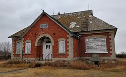
Flaxcombe is an incorporated village in the Canadian province of Saskatchewan within the Rural Municipality of Kindersley No. 290 and Census Division No. 13. The village is located approximately 30 kilometres (19 mi) west of the Town of Kindersley, on Highway 7, and approximately 27 kilometres (17 mi) east of the Alberta-Saskatchewan border.

Glenside is a village in the Canadian province of Saskatchewan within the Rural Municipality of Rudy No. 284 and Census Division No. 11. The village is located on Highway 219 approximately 20 km east of the Town of Outlook.
Hubbard is a village in the Canadian province of Saskatchewan within the Rural Municipality of Ituna Bon Accord No. 246 and Census Division No. 10.
Kendal is a village in the Canadian province of Saskatchewan within the Rural Municipality of Montmartre No. 126 and Census Division No. 6. The village is located 77 km southeast of the city of Regina on Highway 48.
Makwa is a village in the Canadian province of Saskatchewan within the Rural Municipality of Loon Lake No. 561 and Census Division No. 17.
Smiley is a village in the Canadian province of Saskatchewan within the Rural Municipality of Prairiedale No. 321 and Census Division No. 13. The village is located approximately 20 km northwest of the town of Kindersley at the intersection of Highway 307 and Highway 772. The Grand Trunk Pacific Railway was completed in 1913, bringing an economic boom to the village's early years. On April 26, 1987 the Dodsland subdivision between Dodsland and Smiley was transferred to the Canadian Pacific Railway. Due to the close proximity to major grain centres such as Kindersley, CPR put the line up for abandonment and was granted permission to remove the track by the Canadian Transportation Agency on October 29, 1997.
Valparaiso is a village in the Canadian province of Saskatchewan within the Rural Municipality of Star City No. 428 and Census Division No. 14. The village is located at the junction of Highway 3 and Range Road No. 160, approximately 20 km east of the City of Melfort. The name comes from that of Valparaíso in Chile.
Weekes is a village in the Canadian province of Saskatchewan within the Rural Municipality of Porcupine No. 395 and Census Division No. 14. The village is located 29 km east of the town of Porcupine Plain on Highway 23.
Yarbo is a village in the Canadian province of Saskatchewan within the Rural Municipality of Langenburg No. 181 and Census Division No. 5. The village is located 24 km south of the Town of Churchbridge on Highway 80.
Osage is a village in the Canadian province of Saskatchewan within the Rural Municipality of Fillmore No. 96 and Census Division No. 2. The village is located on Highway 33, that runs south-east from Regina to Stoughton. The village has a grain elevator, post office, service station, and a two-sheet natural ice curling rink. Children from the area attend school in Fillmore, 13 km away. Osage celebrated its centennial in 2006.
Coteau Beach is a resort village in the Canadian province of Saskatchewan within Census Division No. 7. It is on the western shore of the Thompson Arm of Lake Diefenbaker in the Rural Municipality of Coteau No. 255. It is 10 kilometres (6.2 mi) east of Highway 45 and approximately 40 kilometres (25 mi) southeast of the town of Outlook.
Sunset Cove is a resort village in the Canadian province of Saskatchewan within Census Division No. 6. It is on the shores of Last Mountain Lake in the Rural Municipality of McKillop No. 220.

The Rural Municipality of Newcombe No. 260 is a rural municipality (RM) in the Canadian province of Saskatchewan within Census Division No. 8 and SARM Division No. 3. It is located in the west-central portion of the province.