Lincoln County | |
---|---|
Coordinates: 31°32′N90°27′W / 31.54°N 90.45°W | |
Country | United States |
State | Mississippi |
Founded | 1870 |
Named for | Abraham Lincoln |
Seat | Brookhaven |
Largest city | Brookhaven |
Area | |
• Total | 588 sq mi (1,520 km2) |
• Land | 586 sq mi (1,520 km2) |
• Water | 2.1 sq mi (5 km2) 0.4% |
Population (2020) | |
• Total | 34,907 |
• Estimate (2023) | 34,702 |
• Density | 59/sq mi (23/km2) |
Time zone | UTC−6 (Central) |
• Summer (DST) | UTC−5 (CDT) |
Congressional district | 3rd |
Website | www |
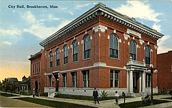
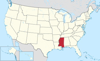
Lincoln County is a county located in the U.S. state of Mississippi. As of the 2020 census, the population was 34,907. [1] Its county seat is Brookhaven. [2] The county was created by the legislature on April 7, 1870, during the Reconstruction Era. It was formed from portions of Lawrence, Pike, Franklin, Copiah, and Amite counties. It was named for Abraham Lincoln, the 16th President of the United States. [3] Lincoln County comprises the Brookhaven, MS Micropolitan Statistical Area, which is included in the Jackson–Vicksburg–Brookhaven Combined Statistical Area. The county is southwest of the state capital of Jackson.
According to the U.S. Census Bureau, the county has a total area of 588 square miles (1,520 km2), of which 586 square miles (1,520 km2) is land and 2.1 square miles (5.4 km2) (0.4%) is water. [4]
Census | Pop. | Note | %± |
---|---|---|---|
1870 | 10,184 | — | |
1880 | 13,547 | 33.0% | |
1890 | 17,912 | 32.2% | |
1900 | 21,552 | 20.3% | |
1910 | 28,597 | 32.7% | |
1920 | 24,652 | −13.8% | |
1930 | 26,357 | 6.9% | |
1940 | 27,506 | 4.4% | |
1950 | 27,899 | 1.4% | |
1960 | 26,759 | −4.1% | |
1970 | 26,198 | −2.1% | |
1980 | 30,174 | 15.2% | |
1990 | 30,278 | 0.3% | |
2000 | 33,166 | 9.5% | |
2010 | 34,869 | 5.1% | |
2020 | 34,907 | 0.1% | |
2023 (est.) | 34,702 | [5] | −0.6% |
U.S. Decennial Census [6] 1790–1960 [7] 1900–1990 [8] 1990–2000 [9] 2010–2013 [10] |
Race | Num. | Perc. |
---|---|---|
White (non-Hispanic) | 22,966 | 65.88% |
Black or African American (non-Hispanic) | 10,484 | 30.03% |
Native American | 63 | 0.18% |
Asian | 163 | 0.47% |
Pacific Islander | 8 | 0.02% |
Other/Mixed | 787 | 2.25% |
Hispanic or Latino | 406 | 1.16% |
As of the 2020 United States census, there were 34,907 people, 12,699 households, and 9,054 families residing in the county.
As of the United States Census of 2000, [12] (which precedes the large changes and increases reflected in the figures, resulting from the substantial annexations and tripling of the size of the City of Brookhaven, the county seat, from late 2007, which would be reflected in the newer United States Census of 2010)—there were 33,166 people, 12,538 households, and 9,190 families residing in the county. The population density was 57 people per square mile (22 people/km2). There were 14,052 housing units at an average density of 24 units per square mile (9.3 units/km2). The racial makeup of the county was 69.38% White, 29.67% Black or African American, 0.17% Native American, 0.24% Asian, 0.01% Pacific Islander, 0.16% from other races, and 0.37% from two or more races. 0.69% of the population were Hispanic or Latino of any race.
There were 12,538 households, out of which 34.90% had children under the age of 18 living with them, 54.90% were married couples living together, 14.70% had a female householder with no husband present, and 26.70% were non-families. 24.40% of all households were made up of individuals, and 11.50% had someone living alone who was 65 years of age or older. The average household size was 2.59 and the average family size was 3.08.
In the county, the population was spread out, with 26.70% under the age of 18, 9.50% from 18 to 24, 27.60% from 25 to 44, 22.30% from 45 to 64, and 13.90% who were 65 years of age or older. The median age was 36 years. For every 100 females there were 92.20 males. For every 100 females age 18 and over, there were 88.60 males.
The median income for a household in the county was $27,279, and the median income for a family was $33,552. Males had a median income of $29,060 versus $18,877 for females. The per capita income for the county was $13,961. About 16.00% of families and 19.20% of the population were below the poverty line, including 22.80% of those under age 18 and 17.10% of those age 65 or over.
The offices of president and vice-president on the county supervisors rotate annually.
This county does not have "home rule;" thus, the legislature reserved to itself power over the county. Its representatives and state senators help serve its residents.
Year | Republican | Democratic | Third party(ies) | |||
---|---|---|---|---|---|---|
No. | % | No. | % | No. | % | |
2024 | 11,432 | 72.35% | 4,262 | 26.97% | 108 | 0.68% |
2020 | 11,596 | 69.02% | 5,040 | 30.00% | 165 | 0.98% |
2016 | 10,550 | 69.44% | 4,458 | 29.34% | 185 | 1.22% |
2012 | 10,839 | 66.04% | 5,471 | 33.33% | 104 | 0.63% |
2008 | 10,781 | 65.73% | 5,505 | 33.56% | 116 | 0.71% |
2004 | 10,008 | 69.04% | 4,418 | 30.48% | 70 | 0.48% |
2000 | 8,540 | 65.69% | 4,358 | 33.52% | 102 | 0.78% |
1996 | 5,960 | 53.85% | 4,294 | 38.80% | 813 | 7.35% |
1992 | 7,040 | 53.78% | 4,744 | 36.24% | 1,307 | 9.98% |
1988 | 8,710 | 65.50% | 4,534 | 34.10% | 53 | 0.40% |
1984 | 8,898 | 66.50% | 4,458 | 33.32% | 25 | 0.19% |
1980 | 7,286 | 57.78% | 5,213 | 41.34% | 111 | 0.88% |
1976 | 6,084 | 58.55% | 4,043 | 38.90% | 265 | 2.55% |
1972 | 7,593 | 86.01% | 1,070 | 12.12% | 165 | 1.87% |
1968 | 1,057 | 10.66% | 1,585 | 15.98% | 7,276 | 73.36% |
1964 | 6,750 | 93.92% | 437 | 6.08% | 0 | 0.00% |
1960 | 1,251 | 25.61% | 1,449 | 29.66% | 2,185 | 44.73% |
1956 | 848 | 22.48% | 1,942 | 51.47% | 983 | 26.05% |
1952 | 2,028 | 47.17% | 2,271 | 52.83% | 0 | 0.00% |
1948 | 40 | 1.26% | 52 | 1.64% | 3,085 | 97.10% |
1944 | 103 | 4.04% | 2,445 | 95.96% | 0 | 0.00% |
1940 | 97 | 3.98% | 2,332 | 95.57% | 11 | 0.45% |
1936 | 74 | 2.90% | 2,465 | 96.70% | 10 | 0.39% |
1932 | 92 | 3.71% | 2,379 | 95.97% | 8 | 0.32% |
1928 | 422 | 16.15% | 2,191 | 83.85% | 0 | 0.00% |
1924 | 154 | 10.25% | 1,278 | 85.09% | 70 | 4.66% |
1920 | 421 | 34.85% | 774 | 64.07% | 13 | 1.08% |
1916 | 105 | 7.46% | 1,282 | 91.12% | 20 | 1.42% |
1912 | 41 | 4.43% | 768 | 83.03% | 116 | 12.54% |
The telecommunications company MCI Worldcom was located in Lincoln County. Its chief executive officer (CEO) and founder Bernard Ebbers resided near Brookhaven prior to his conviction; he was sentenced to prison.
The county is served by two separate public school districts (Lincoln County Public School District and Brookhaven School District), [14] a private school, and a couple of smaller Christian or religious/private schools.
The Lincoln County School District consists of four K–12 schools of elementary, middle school, and high school levels. These include Loyd Star hornets, Bogue Chitto bobcats, West Lincoln bears and the Enterprise yellowjackets. Through annexations, the City tripled its size in 2007. As well a Brookhaven Academy cougars which is a part of the MAPS or MAIS.
It is in the district of Copiah–Lincoln Community College. [15]
Lincoln County is served by the local newspaper Daily Leader, printed daily except Monday and Saturday. Residents may also purchase the larger daily newspaper from the state capital of Jackson, The Clarion-Ledger, which serves the central state metropolitan area and the entire State of Mississippi.
Warren County is a county located in the U.S. state of Mississippi. Its western border is formed by the Mississippi River. As of the 2020 census, the population was 44,722. Its county seat is Vicksburg. Established by legislative act of December 22, 1809, Warren County is named for American Revolutionary War officer Joseph Warren.
Walthall County is a county located in the U.S. state of Mississippi. As of the 2020 census, the population was 13,884. Its county seat is Tylertown. The county is named after Civil War Confederate general and Mississippi Senator Edward C. Walthall.
Union County is a county located in the U.S. state of Mississippi. It was formed in 1870 from Tippah and Pontotoc counties, and in 1874 a portion of Lee County was added. As of the 2020 census, the population was 27,777. Its county seat is New Albany. According to most sources, the county received its name by being a union of pieces of several large counties, like other Union counties in other states. However, other sources say that the name was meant to mark the re-union of Mississippi and the other Confederate states after the Civil War.
Tippah County is a county located on the northern border of the U.S. state of Mississippi. As of the 2020 census, the population was 21,815. Its county seat is Ripley. The name "Tippah" is derived from a Chickasaw language word meaning "cut off." It was taken from the creek of the same name that flows across much of the original county from northeast to southwest before emptying into the Tallahatchie River. The creek probably was so named because it, and the ridges on either side, "cut off" the western part of the region from the eastern portion.
Prentiss County is a county located in the U.S. state of Mississippi. As of the 2020 census, the population was 25,008. Its county seat is Booneville. The county is named for Seargent Smith Prentiss, a noted speaker and US Congressman from Natchez.
Pontotoc County is a county located in the U.S. state of Mississippi. As of the 2020 census, the population was 31,184. Its county seat is Pontotoc. It was created on February 9, 1836, from lands ceded to the United States under the Chickasaw Cession. Pontotoc is a Chickasaw word meaning "land of hanging grapes". The original Natchez Trace and the current-day Natchez Trace Parkway both pass through the southeast corner of Pontotoc County.
Neshoba County is a county located in the central part of the U.S. state of Mississippi. As of the 2020 census, the population was 29,087. Its county seat is Philadelphia.
Lawrence County is a county located in the U.S. state of Mississippi. As of the 2020 census, the population was 12,016. Its county seat is Monticello. The county is named for the naval hero James Lawrence.
Alcorn County is a county located in the northeastern portion of the U.S. state of Mississippi. As of the 2020 census, the population was 34,740. Its county seat is Corinth. The county is named in honor of Governor James L. Alcorn. The Corinth Micropolitan Statistical Area includes all of Alcorn County.
Washington Parish is a parish located in the interior southeast corner of the U.S. state of Louisiana, one of the Florida Parishes. As of the 2020 census, the population was 45,463. Its parish seat is Franklinton. Its largest city is Bogalusa. The parish was founded in 1819.
Amite City is a town in and the seat of Tangipahoa Parish in southeastern Louisiana, United States. The population was 4,141 at the 2010 census. It is part of the Hammond MSA.
Beauregard is a village in Copiah County, Mississippi, United States. The population was 326 at the 2010 census. It is part of the Jackson Metropolitan Statistical Area. Beauregard is named for P. G. T. Beauregard.
Georgetown is a town in Copiah County, Mississippi, United States. The population was 286 at the 2010 census. With its eastern border formed by the Pearl River, it is part of the Jackson Metropolitan Statistical Area.
Wesson is a town in Copiah and Lincoln counties, Mississippi, United States. The population was 1,925 at the 2010 census. It is part of the Jackson Metropolitan Statistical Area.
Flowood is a city in Rankin County, Mississippi, United States. The population was 10,202 as of the 2020 census. A suburb of Jackson, Flowood is part of the Jackson Metropolitan Statistical Area, and is located northeast of the state capital.
Brookhaven is a small city in Lincoln County, Mississippi, United States, 55 miles (89 km) south of the state capital of Jackson. The population was 11,674 people at the 2020 U.S. Census. It is the county seat of Lincoln County. It was named after the town of Brookhaven, New York, by founder Samuel Jayne in 1818.
Brookhaven is a census-designated place (CDP) in Monongalia County, West Virginia, United States. The population was 5,707 at the 2020 census. It is included in the Morgantown, West Virginia Metropolitan Statistical Area.
Bogue Chitto is a census-designated place (CDP) situated in Kemper and Neshoba counties, Mississippi. The population was 864 at the 2020 census. It is part of the Mississippi Band of Choctaw Indians Reservation and the population is 93% Choctaw.
Bogue Chitto is an unincorporated community and census-designated place (CDP) in Lincoln County, Mississippi, United States. As of the 2020 census, it had a population of 437. Bogue Chitto is the only municipal hamlet in the state of Mississippi.
The Jackson–Vicksburg–Brookhaven, MS Combined Statistical Area is made up of eight counties in central Mississippi and consists of the Jackson Metropolitan Statistical Area, the Brookhaven, MS Micropolitan Statistical Area, the Vicksburg micropolitan area, and the Yazoo City Micropolitan Statistical Area. The 2010 census placed the Jackson–Vicksburg–Brookhaven CSA population at 650,764, although as of 2019, it's estimated to have increased to 666,318.