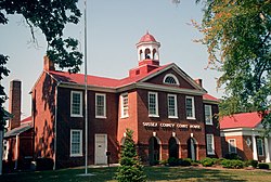
Sussex County | |
---|---|
Coordinates: 36°56′N77°16′W / 36.93°N 77.26°W | |
Country | United States |
State | Virginia |
Founded | 1754 |
Named for | Sussex, England |
Seat | Sussex |
Largest town | Waverly |
Area | |
• Total | 493 sq mi (1,280 km2) |
• Land | 490 sq mi (1,300 km2) |
• Water | 2.6 sq mi (7 km2) 0.5% |
Population (2020) | |
• Total | 10,829 |
• Density | 22/sq mi (8.5/km2) |
Time zone | UTC−5 (Eastern) |
• Summer (DST) | UTC−4 (EDT) |
Congressional district | 4th |
Website | www |
Sussex County is a rural county located in the southeast of the Commonwealth of Virginia. As of the 2020 census, the population was 10,829. [1] Its county seat is Sussex. [2] It was formed in 1754 from Surry County. The county is named after the county of Sussex, England. [3]
Sussex County is included in the Greater Richmond Region.
Native Americans may have settled near Cactus Hill along the Nottoway River as long as 10,000 years ago. This area later was organized by English colonists as Sussex County. [4] The historic Nottoway people, although they spoke an Iroquoian language, were loosely part of the Powhatan Confederacy. It was composed mainly of Algonquian-speaking peoples from the coastal zone.
When colonists arrived from England in 1607, some traveled along the Nottoway River. But when they established the first counties in the colony, James City County included both sides of the James River to the North Carolina line. The south side of the James River later was organized as Surry County in 1652. Virginia's General Assembly formed Sussex County in 1754 from the southwestern end of Surry County.
Sussex County has maintained a predominantly agricultural economy, once based in tobacco and cotton commodity crops, with work primarily done by enslaved African Americans. It has preserved some of its historic heritage for centuries. Important sites include the Nottoway Archeological Site, Sussex County Courthouse Historic District and the Waverly Downtown Historic District, and six historic homes, all listed on the National Register of Historic Places.
The largest forest fire in Virginia's recorded history occurred on April 5, 1943, destroying more than 12,000 acres in six hours. Fire were usually fought by recruiting workmen from Gray Lumber Company, but the mill was closed and most were attending the funeral of Ella Darden Gray, matriarch of one of the county's leading families. Her son Senator Garland Gray helped bring attention to the state's need for more protection for valuable forests. [5]
About a decade later, Senator Gray became a leader in the Massive Resistance of whites against desegregating Virginia's public schools. [6]
According to the U.S. Census Bureau, the county has a total area of 493 square miles (1,280 km2), of which 490 square miles (1,300 km2) is land and 2.6 square miles (6.7 km2) (0.5%) is water. [7]
Census | Pop. | Note | %± |
---|---|---|---|
1790 | 10,549 | — | |
1800 | 11,062 | 4.9% | |
1810 | 11,362 | 2.7% | |
1820 | 11,884 | 4.6% | |
1830 | 12,720 | 7.0% | |
1840 | 11,229 | −11.7% | |
1850 | 9,820 | −12.5% | |
1860 | 10,175 | 3.6% | |
1870 | 7,885 | −22.5% | |
1880 | 10,062 | 27.6% | |
1890 | 11,100 | 10.3% | |
1900 | 12,082 | 8.8% | |
1910 | 13,664 | 13.1% | |
1920 | 12,834 | −6.1% | |
1930 | 12,100 | −5.7% | |
1940 | 12,485 | 3.2% | |
1950 | 12,785 | 2.4% | |
1960 | 12,411 | −2.9% | |
1970 | 11,464 | −7.6% | |
1980 | 10,874 | −5.1% | |
1990 | 10,248 | −5.8% | |
2000 | 12,504 | 22.0% | |
2010 | 12,087 | −3.3% | |
2020 | 10,829 | −10.4% | |
2021 (est.) | 10,763 | [8] | −0.6% |
U.S. Decennial Census [9] 1790-1960 [10] 1900-1990 [11] 1990-2000 [12] 2010 [13] 2020 [14] |
Race / Ethnicity (NH = Non-Hispanic) | Pop 2000 [15] | Pop 2010 [13] | Pop 2020 [14] | % 2000 | % 2010 | % 2020 |
---|---|---|---|---|---|---|
White alone (NH) | 4,537 | 4,663 | 4,381 | 36.28% | 38.58% | 40.46% |
Black or African American alone (NH) | 7,750 | 6,996 | 5,766 | 61.98% | 57.88% | 53.25% |
Native American or Alaska Native alone (NH) | 16 | 19 | 14 | 0.13% | 0.16% | 0.13% |
Asian alone (NH) | 15 | 46 | 11 | 0.12% | 0.38% | 0.10% |
Pacific Islander alone (NH) | 1 | 0 | 7 | 0.01% | 0.00% | 0.06% |
Other race alone (NH) | 5 | 9 | 25 | 0.04% | 0.07% | 0.23% |
Mixed race or Multiracial (NH) | 78 | 86 | 319 | 0.62% | 0.71% | 2.95% |
Hispanic or Latino (any race) | 102 | 268 | 306 | 0.82% | 2.22% | 2.83% |
Total | 12,504 | 12,087 | 10,829 | 100.00% | 100.00% | 100.00% |
As of the 2010 United States Census, there were 12,087 people living in the county, of which 58.1% were Black or African American, 39.3% White, 0.4% Asian, 0.2% Native American, 1.3% of some other race and 0.8% of two or more races. 2.2% were Hispanic or Latino (of any race).
As of the census [16] of 2000, there were 12,504 people, 4,126 households, and 2,809 families living in the county. The population density was 26 people per square mile (10 people/km2). There were 4,653 housing units at an average density of 10 units per square mile (3.9 units/km2). The racial makeup of the county was 62.13% Black or African American, 36.39% White, 0.13% Native American, 0.12% Asian, 0.02% Pacific Islander, 0.54% from other races, and 0.67% from two or more races. 0.82% of the population were Hispanic or Latino of any race.
There were 4,126 households, out of which 28.50% had children under the age of 18 living with them, 45.00% were married couples living together, 18.90% had a female householder with no husband present, and 31.90% were non-families. 28.20% of all households were made up of individuals, and 12.40% had someone living alone who was 65 years of age or older. The average household size was 2.41 and the average family size was 2.94.
In the county, the population was spread out, with 19.60% under the age of 18, 9.00% from 18 to 24, 34.40% from 25 to 44, 23.60% from 45 to 64, and 13.40% who were 65 years of age or older. The median age was 38 years. For every 100 females there were 135.10 males. For every 100 females age 18 and over, there were 142.30 males.
The median income for a household in the county was $31,007, and the median income for a family was $36,739. Males had a median income of $29,307 versus $22,001 for females. The per capita income for the county was $14,670. About 12.80% of families and 16.10% of the population were below the poverty line, including 24.30% of those under age 18 and 19.20% of those age 65 or over.
Two prisons were built in Sussex County in the 1990s. Including the prisons, Sussex County was the fastest growing county in the United States. Excluding the prisons, the county population declined. [17]
Sussex County Public Schools operates public schools for the entire county. [18]
Blackwater Regional Library is the regional library system that provides services to the citizens of Sussex.
The Virginia Department of Corrections operates the Sussex I State Prison and the Sussex II State Prison in unincorporated Sussex County, near Waverly. [19] [20] [21] The Sussex I center housed the male death row. On August 3, 1998, the male death row moved to Sussex I from the Mecklenburg Correctional Center. [22]
The country is majority-Black, and has consistently voted for the Democratic Party in presidential elections since 1976.
Year | Republican | Democratic | Third party(ies) | |||
---|---|---|---|---|---|---|
No. | % | No. | % | No. | % | |
2020 | 2,219 | 43.61% | 2,827 | 55.56% | 42 | 0.83% |
2016 | 2,055 | 40.74% | 2,879 | 57.08% | 110 | 2.18% |
2012 | 2,021 | 37.15% | 3,358 | 61.73% | 61 | 1.12% |
2008 | 2,026 | 37.78% | 3,301 | 61.55% | 36 | 0.67% |
2004 | 1,890 | 43.50% | 2,420 | 55.70% | 35 | 0.81% |
2000 | 1,745 | 44.67% | 2,006 | 51.36% | 155 | 3.97% |
1996 | 1,378 | 36.34% | 2,089 | 55.09% | 325 | 8.57% |
1992 | 1,527 | 35.90% | 2,193 | 51.56% | 533 | 12.53% |
1988 | 1,822 | 46.77% | 1,958 | 50.26% | 116 | 2.98% |
1984 | 2,183 | 46.14% | 2,408 | 50.90% | 140 | 2.96% |
1980 | 1,664 | 38.94% | 2,447 | 57.27% | 162 | 3.79% |
1976 | 1,360 | 33.22% | 2,497 | 60.99% | 237 | 5.79% |
1972 | 2,120 | 54.99% | 1,645 | 42.67% | 90 | 2.33% |
1968 | 1,105 | 29.12% | 1,541 | 40.62% | 1,148 | 30.26% |
1964 | 1,537 | 55.39% | 1,234 | 44.47% | 4 | 0.14% |
1960 | 713 | 35.78% | 1,253 | 62.87% | 27 | 1.35% |
1956 | 785 | 39.31% | 851 | 42.61% | 361 | 18.08% |
1952 | 888 | 47.97% | 956 | 51.65% | 7 | 0.38% |
1948 | 244 | 20.00% | 614 | 50.33% | 362 | 29.67% |
1944 | 201 | 20.51% | 773 | 78.88% | 6 | 0.61% |
1940 | 164 | 18.16% | 737 | 81.62% | 2 | 0.22% |
1936 | 126 | 12.52% | 880 | 87.48% | 0 | 0.00% |
1932 | 122 | 14.79% | 688 | 83.39% | 15 | 1.82% |
1928 | 385 | 41.31% | 547 | 58.69% | 0 | 0.00% |
1924 | 132 | 17.67% | 607 | 81.26% | 8 | 1.07% |
1920 | 166 | 23.15% | 548 | 76.43% | 3 | 0.42% |
1916 | 96 | 16.35% | 486 | 82.79% | 5 | 0.85% |
1912 | 59 | 10.52% | 435 | 77.54% | 67 | 11.94% |
Bradford County is a county in the north central region of the U.S. state of Florida. As of the 2020 census, the population was 28,303. Its county seat and largest city is Starke.
Union County is a county located in the north central portion of the U.S. state of Florida, the smallest in the state by area. As of the 2020 census, the population was 16,147. The county seat is Lake Butler.
Escambia County is a county located in the south central portion of the U.S. state of Alabama. As of the 2020 census, the population was 36,757. Its county seat is Brewton.
Southampton County is a county located on the southern border of the Commonwealth of Virginia. North Carolina is to the south. As of the 2020 census, the population was 17,996. Its county seat is Courtland.
Prince George County is a county located in the Commonwealth of Virginia. As of the 2020 census, the population was 43,010. Its county seat is Prince George.
Nottoway County is a county located in the Commonwealth of Virginia. As of the 2020 census, the population was 15,642. Its county seat is Nottoway. It is situated south of the James River, thus making it a part of the Southside Virginia Region.
Greensville County is a county located in the Commonwealth of Virginia. As of the 2020 census, the population was 11,391. Its county seat is Emporia.
Emporia is an independent city in the Commonwealth of Virginia, surrounded by Greensville County, United States. Emporia and a predecessor town have been the county seat of Greensville County since 1791. As of the 2020 census, the population was 5,766, making it the third-least populous city in Virginia. The Bureau of Economic Analysis combines the city of Emporia with surrounding Greensville County for statistical purposes. The town has become notorious for being a major speed trap.
Dinwiddie County is a county located in the Commonwealth of Virginia. As of the 2020 census, the population was 27,947. Its county seat is Dinwiddie.
Brunswick County is a United States county located on the southern border of the Commonwealth of Virginia. This rural county is known as one of the claimants to be the namesake of Brunswick stew. Brunswick County was created in 1720 from parts of Prince George, Surry and Isle of Wight counties. The county was named for the former Duchy of Brunswick-Lunenburg, the region from which the British monarchs of the House of Hanover originated. As of the 2020 census, the county population was 15,849. The Brunswick county seat is Lawrenceville.
Walker County is a county located in the east central section of the U.S. state of Texas. As of the 2020 census, its population was 76,400. Its county seat is Huntsville. Initially, Walker County was named for Robert J. Walker, a legislator from Mississippi who introduced into the United States Congress the resolution to annex Texas. Walker later supported the U.S. during its Civil War and earned some enmity for it. In order to keep the county's name, the state renamed it for Samuel H. Walker, a Texas Ranger and soldier in the United States Army.
Hardeman County is a county located in the U.S. state of Tennessee. As of the 2020 census, the population was 25,462. Its county seat is Bolivar.
Burkeville is an incorporated town in Nottoway County, Virginia, United States. The population was 432 at the 2010 census. The source of the town name is disputed. The town is located at the crossroads of U.S. routes 360 and 460.
Crewe is a town in Nottoway County, Virginia, United States. The population was 2,262 at the 2020 census.
Dendron is a town in Surry County, Virginia, United States. The population was 251 at the 2020 census. Sculptor Leslie Garland Bolling was born in Dendron, as was mayor of Hopewell, Virginia, Curtis W. Harris.
Surry is an incorporated town in Surry County, Virginia, United States. The population was 244 at the 2010 census. It is the county seat of Surry County. Its name is derived from the historic county of Surrey in England.
Waverly is an incorporated town in Sussex County, Virginia, United States. Per the 2020 census, the population was 1,955.
Jarratt is a town in Greensville and Sussex counties in the U.S. state of Virginia. The population was 652 at the 2020 census. In 1848, Jarratt was a stop on the Petersburg Railroad. Jaratt was incorporated in 1938.
Surry County is a county in the southeastern part of the Commonwealth of Virginia. As of the 2020 census, the population was 6,561.
Sussex I State Prison is a prison of the Virginia Department of Corrections located in unincorporated Sussex County, Virginia, near Waverly. It is adjacent to Sussex II State Prison, which lies to its northwest, just across Mussellwhite Drive.