Extreme points of Earth

Last updated

This is a list of extreme points on Earth, the geographical locations that are farther north or south than, higher or lower in elevation than, or farthest inland or out to sea from, any other locations on the landmasses, continents or countries.

Contents

For other lists of extreme points on Earth, including places that hold temperature and weather records, see Extremes on Earth, Lists of extreme points, and List of weather records.

Earth

Latitude and longitude

Elevation

Highest points

Chimborazo in Ecuador is the farthest point from Earth's centre. Volcan Chimborazo, "El Taita Chimborazo".jpg
Chimborazo in Ecuador is the farthest point from Earth's centre.
  • The highest point on Earth's surface measured from sea level is the summit of Mount Everest on the border of Nepal and China. While measurements of its height vary slightly, the elevation of its peak was most recently established in 2020 by the Nepali and Chinese authorities as 8,848.86 m (29,032 ft) above sea level [3] It was first reached by Sir Edmund Hillary of New Zealand and Sherpa of Nepal Tenzing Norgay in 1953.
  • The point farthest from Earth's centre is the summit of Chimborazo [4] in Ecuador, at 6,384.4 km (3,967.1 mi) from Earth's centre; the peak's elevation relative to sea level is 6,263.47 m (20,549 ft). [note 2] This is because Earth is an oblate spheroid rather than a perfect sphere; it is wider at the Equator and narrower between the poles. Therefore, the summit of Chimborazo, which is near the Equator, is farther away from Earth's centre than the summit of Mount Everest is; the latter is 2,168 m (7,112.9 ft) closer, at 6,382.3 km (3,965.8 mi) from Earth's centre. Peru's Huascarán (at 6,768 m or 22,205 ft) contends closely with Chimborazo, the difference in the mountains' heights being just 23 m (75 ft).
  • The fastest point on Earth or, in other words, the point furthest from the axis of Earth is the summit of Cayambe [6] in Ecuador, at 1,675.89 km/h (1,041.35 mph) and 6,383.95 km (3,966.80 mi) from the axis. Like Chimborazo, which is the fourth fastest peak at 1,675.47 km/h (1,041.09 mph), it is close to the Equator and takes advantage of the oblate spheroid figure of Earth. More importantly, however, it being so near the Equator means that the majority of its distance from Earth's centre goes into it being away from the axis.
Highest points attainable by transportation
  • The highest point accessible...
    • ...by land vehicle is an elevation of 6,688 m (21,942 ft) on Ojos del Salado in Chile, which was reached by the Chilean duo of Gonzalo and Eduardo Canales Moya on 21 April 2007 with a modified Suzuki Samurai, setting the high-altitude record for a four-wheeled vehicle.
    • ...by road (dead end) is on a mining road to the summit of Aucanquilcha in Chile, which reaches an elevation of 6,176 m (20,262 ft). It was once usable by 20-tonne mining trucks. [7] The road is no longer usable. 21°12′50″S68°28′30″W / 21.214°S 68.475°W / -21.214; -68.475
    • ...by road (mountain pass) is disputed; there are a number of competing claims for this title due to the definition of "motorable pass" (i.e. a surfaced road or one simply passable by a vehicle):
      • The highest asphalted road crosses Tibet's Semo La pass at 5,565 m (18,258 ft). It is used by trucks and buses regularly. [8] The Ticlio pass, on the Central Road of Peru, is the highest surfaced road in the Americas, at an elevation of 4,818 m (15,807 ft).
      • The highest unsurfaced road is claimed by several different roads. All are unsurfaced or gravel roads including the barely passable road to Umling, LA, 17 km (11 mi) west of Demchok in Ladakh, India, which reaches 5,800 m (19,029 ft) ("19,300 feet" according to a Border Roads Organisation sign there that recognizes it as the "World's Highest Motorable Pass"), [9] and Mana Pass, between India and Tibet, which is crossed by a gravel road reaching 5,610 m (18,406 ft). The heavily trafficked Khardung La in Ladakh lies at 5,359 m (17,582 ft). A possibly motorable gravel road crosses Marsimik La in Ladakh at 5,582 m (18,314 ft).
    • ...by train is Tanggula Pass, located on the Qinghai–Tibet (Qingzang) Railway in the Tanggula Mountains of Qinghai/Tibet, China, at 5,072 m (16,640 ft). The Tanggula railway station is the world's highest railway station at 5,068 m (16,627 ft). Before the Qingzang Railway was built, the highest railway ran between Lima and Huancayo in Peru, reaching 4,829 m (15,843 ft) at Ticlio. [10]
    • ...by oceangoing vessel is a segment of the Rhine–Main–Danube Canal between the Hilpoltstein and Bachhausen locks in Bavaria, Germany. The locks artificially raise the surface level of the water in the canal to 406 m (1,332 ft) above mean sea level, higher than any other lock system in the world, making it the highest point currently accessible by oceangoing commercial watercraft.
La Rinconada, Peru La Rinconada Peru.jpg
La Rinconada, Peru
  • The highest commercial airport is Daocheng Yading Airport, Sichuan, China, at 4,411 m (14,472 ft). [11] The proposed Nagqu Dagring Airport in Tibet, if built, will be 25 m (82 ft) higher at 4,436 m (14,554 ft).
  • The highest helipad is Sonam, Siachen Glacier, India, at a height of 6,400 m (20,997 ft) above sea level. [12]
  • The highest permanent human settlement is La Rinconada, Peru, 5,100 m (16,732 ft), in the Peruvian Andes.
  • The farthest road from the Earth's centre is the Road to Carrel Hut in the Ecuadorian Andes, at an elevation of 4,850 m (15,912 ft) above sea level and a distance of 6,382.9 km (3,966 mi) from the centre of the Earth. [13]
Highest geographical features

Lowest points

Lowest artificial points
Lowest natural points
The shore of the Dead Sea in Israel Dead Sea-14.jpg
The shore of the Dead Sea in Israel
  • The lowest point on dry land is the shore of the Dead Sea, shared by Israel, Palestine, and Jordan, 432.65 m (1,419 ft) below sea level. As the Dead Sea waters are receding, the water surface level drops more than 1 m per year. [26]
  • The point on the surface closest to the Earth's centre (interpreted as a natural surface of the land or sea that is accessible by a person) is the surface of the Arctic Ocean at the Geographic North Pole (6,356.77 km or 3,950 mi).
    • The closest point on the ground (interpreted as a land surface or sea floor) is the bottom of the Litke Deep, which is 6,351.61 km (3,947 mi) from the centre of the Earth.[ citation needed ] By comparison, the bottom of the deepest oceanic trench in the world, the Mariana Trench in the Pacific Ocean, is 14.7 km (9 mi) farther from the centre of the Earth.
Lowest points attainable by transportation
Lowest cities

Baku, Azerbaijan is located 28 m (92 ft) below sea level, which makes it the lowest-lying national capital in the world and also the largest city in the world located below sea level.

Remoteness

Poles of inaccessibility

Each continent has its own continental pole of inaccessibility, defined as the place on the continent that is farthest from any ocean. Similarly, each ocean has its own oceanic pole of inaccessibility, defined as the place in the ocean that is farthest from any land.

Continental
If adopted, this would place the final EPIA roughly 130 km (81 mi) closer to the ocean than the point that is currently agreed upon. [27] Coincidentally, EPIA1, or EPIA2, and the most remote of the Oceanic Pole of Inaccessibility (specifically, the point in the South Pacific Ocean that is farthest from land) are similarly remote; EPIA1 is less than 200 km (120 mi) closer to the ocean than the Oceanic Pole of Inaccessibility is to land.
Oceanic

Other places considered the most remote

Bouvet Island Bouvet Island ISS017-E-16161 no text.JPG
Bouvet Island
  • The most remote island is Bouvet Island, a small, uninhabited island in the South Atlantic Ocean that is a dependency of Norway. It lies at coordinates 54°26′S3°24′E / 54.433°S 3.400°E / -54.433; 3.400 (most remote island) . The nearest land is the uninhabited Queen Maud Land, Antarctica, over 1,600 km (994 mi) to the south. The nearest inhabited lands are Gough Island, 1,845 km (1,146 mi) away, Tristan da Cunha, 2,260 km (1,404 mi) away, and the coast of South Africa, 2,580 km (1,603 mi) away.
  • The title for most remote inhabited island or archipelago (the farthest away from any other permanently inhabited place) depends on how the question is interpreted. If the south Atlantic island Tristan da Cunha (population about 300) and its dependency Gough Island (with a small staffed research post), which are 399 km (248 mi) from each other, are considered part of the same archipelago, or if Gough Island is not counted because it has no permanent residents, then Tristan da Cunha is the world's most remote inhabited island/archipelago: the main island, also called Tristan da Cunha, is 2,434 km (1,512 mi) from the island Saint Helena, 2,816 km (1,750 mi) from South Africa, and 3,360 km (2,090 mi) from South America. It is 2,260 km (1,404 mi) away from uninhabited Bouvet Island. However, if Gough and Tristan da Cunha are considered separately, they disqualify each other, and the most remote inhabited island is Easter Island in the South Pacific Ocean, which lies 2,075 km (1,289 mi) from Pitcairn Island (about 50 residents in 2013), 2,606 km (1,619 mi) from Rikitea on the island of Mangareva (the nearest town with a population over 500), and 3,512 km (2,182 mi) from the coast of Chile (the nearest continental point and the country of which Easter Island is part). The Kerguelen Islands in the southern Indian Ocean are another contender, lying 1,340 km (830 mi) from the small Alfred Faure scientific station in Île de la Possession, but otherwise more than 3,300 km (2,100 mi) from the coast of Madagascar (the nearest permanently inhabited place), 450 km (280 mi) northwest of the uninhabited Heard Island and McDonald Islands (both a part of Australia), and 1,440 km (890 mi) from the non-permanent scientific station located in Île Amsterdam.
  • The most remote city...
    • ...with a population in excess of one million from the nearest city with a population in excess of one million is Auckland, New Zealand. The nearest city of comparable size or greater is Sydney, Australia, 2,168.9 km (1,347.7 mi) away. [30]
    • ...with a population in excess of one million from the nearest city with a population above 100,000 is Perth, Australia, located 2,138 km (1,328 mi) [31] away from Adelaide, Australia.
    • ...with a population in excess of 100,000 from the nearest city of at least that population is Honolulu, Hawaii, United States. The nearest city of comparable size or greater is San Francisco, 3,850 km (2,390 mi) away. [32]
    • ...that is a national capital from the nearest national capital is a tie between Wellington, New Zealand, and Canberra, Australia, which are 2,326 km (1,445 mi) apart from each other.
  • The most remote airport in the world from another airport is Mataveri International Airport (IPC) on Easter Island, which has a single runway for military and public use. It is located 2,603 km (1,617 mi) from Totegegie Airport (GMR; very few flights) in the Gambier Islands, French Polynesia and 3,759 km (2,336 mi) from Santiago, Chile (SCL; a fairly large airport). In comparison, the airport at the Amundsen–Scott South Pole Station (NZSP) is not very remote at all, being located only 1,355 km (842 mi) from Williams Field (NZWD) near Ross Island. [33]

Farthest-apart cities

The pairs of cities (with a population over 100,000) with the greatest distance between them (antipodes) are: [34]

  1. Rosario, Argentina to Xinghua, China: 19,996 km (12,425 mi) [35]
  2. Lu'an, China to Río Cuarto, Argentina: 19,994 km (12,424 mi) [36]
  3. Cuenca, Ecuador to Subang Jaya, Malaysia: 19,989 km (12,421 mi) [37]
  4. Shanghai, China to Concordia, Argentina: 19,984 km (12,417 mi) [38]
  5. Rancagua, Chile to Xi'an, China: 19,972 km (12,410 mi) [39]
  6. Resistencia, Argentina to Rui'an, China: 19,967 km (12,407 mi) [40]
  7. Yantai, China to Tandil, Argentina: 19,965 km (12,406 mi) [41]
  8. Coquimbo, Chile to Lichuan, China: 19,964 km (12,405 mi) [42]
  9. Bandung, Indonesia to Piedecuesta, Colombia: 19,962 km (12,404 mi) [43]
  10. Salamanca, Spain to Lower Hutt, New Zealand: 19,961 km (12,403 mi) [44]

The pair of airports having scheduled flights having the greatest distance between them has been measured to be Sultan Mahmud Badaruddin II International Airport, which serves Palembang, Indonesia, and Benito Salas Airport, which serves Neiva, Colombia, located about 10,819 nautical miles (20,037 km) apart. [45]

Centre

Longest lines between two points

Along constant latitude

Along constant longitude

Along any geodesic

These are the longest straight lines that can be drawn between any two points on the surface of the Earth and remain exclusively over land or water; the points need not lie on the same latitude or longitude.

Along a line 13,573 km (8,434 mi) that begins on the West African coast near Greenville, Liberia ( 5°2′51.59″N9°7′23.26″W / 5.0476639°N 9.1231278°W / 5.0476639; -9.1231278 ), goes across the Suez Canal, and ends at the top of a peninsula approximately 100 km (62 mi) northeast of Wenzhou, China 28°17′7.68″N121°38′17.31″E / 28.2854667°N 121.6381417°E / 28.2854667; 121.6381417 . [47]

Along any truly straight line

As distinct from all the aforementioned geodesic lines, which may appear straight but are actually arcs of great circles projected on the spheroidal surface of the earth and, accordingly, are not truly straight but rather curving lines, authentically straight lines can be projected through the interior of the earth between almost any two points on the surface of the earth (some extreme topographical situations being the rare exceptions). If a line projected from the summit of Cayambe in Ecuador (see highest points) to the axial centre of the earth is extended to its antipode on the island of Sumatra, then the resulting diametrical line would be the longest truly straight line that could be produced anywhere on earth. As the variable circumference of the earth approaches 40,000 kilometres (25,000 mi), such a maximum "diametrical" or "antipodal" line would be on the order of 13,000 kilometres (8,000 mi) long.

By region

Afro-Eurasia

The Americas

Oceania

Antarctica

Arctic

See also

Notes

  1. A 1995 realignment of the International Date Line Archived 28 June 2006 at the Wayback Machine moved all of Kiribati to the Asian side of the Date Line, causing Caroline Island to be the easternmost. However, if the previous Date Line were followed, the easternmost point would be Tafahi Niuatoputapu, in the Tonga Islands chain.
  2. The elevation given here was established by a GPS survey in February 2016. The survey was carried out by a team from the French Research Institute for Development, working in cooperation with the Ecuadorian Military Geographic Institute. [5]

Related Research Articles

Geography of Antarctica Geographic features of Antarctica

The geography of Antarctica is dominated by its south polar location and, thus, by ice. The Antarctic continent, located in the Earth's southern hemisphere, is centered asymmetrically around the South Pole and largely south of the Antarctic Circle. It is washed by the Southern Ocean or, depending on definition, the southern Pacific, Atlantic, and Indian Oceans. It has an area of more than 14 million km2.

Geography of Africa Geographical features of Africa

Africa is a continent comprising 63 political territories, representing the largest of the great southward projections from the main mass of Earth's surface. Within its regular outline, it comprises an area of 30,368,609 km2 (11,725,385 sq mi), excluding adjacent islands. Its highest mountain is Mount Kilimanjaro, its largest lake is Lake Victoria.

North Pole Northern point where the Earths axis of rotation intersects its surface

The North Pole, also known as the Geographic North Pole or Terrestrial North Pole, is the point in the Northern Hemisphere where the Earth's axis of rotation meets its surface. It is called the True North Pole to distinguish from the Magnetic North Pole.

Antipodes Diametrically opposite points on Earths surface

In geography, the antipode of any spot on Earth is the point on Earth's surface diametrically opposite to it. A pair of points antipodal to each other are situated such that a straight line connecting the two would pass through Earth's center. Antipodal points are as far away from each other as possible.

Pole of inaccessibility

A pole of inaccessibility with respect to a geographical criterion of inaccessibility marks a location that is the most challenging to reach according to that criterion. Often it refers to the most distant point from the coastline, implying a maximum degree of continentality or oceanity. In these cases, pole of inaccessibility can be defined as the center of the largest circle that can be drawn within an area of interest without encountering a coast. Where a coast is imprecisely defined, the pole will be similarly imprecise.

Extreme points of Eurasia

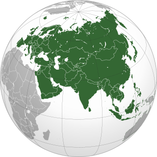
This is a list of the extreme points of Eurasia, the points that are farther north, south, east or west than any other location on the continent. Some of these locations are open to debate, owing to the diverse definitions of Europe and Asia.

Extreme points of Norway

The extreme points of Norway include the coordinates that are farther north, south, east or west than any other location in Norway; and the highest and the lowest altitudes in the country. The northernmost point is Rossøya on Svalbard, the southernmost is Pysen in Mandal, the easternmost is Kræmerpynten on Svalbard, and the westernmost is Hoybergodden on Jan Mayen. The highest peak is Galdhøpiggen, standing at 2,469 m (8,100 ft) above mean sea level, while the lowest elevation is sea level at the coast.

Extreme points of North America

This is a list of the extreme points of North America: the points that are highest and lowest, and farther north, south, east or west than any other location on the continent. Some of these points are debatable, given the varying definitions of North America.

Dome A

Dome A or Dome Argus is the loftiest ice dome on the Antarctic Plateau, located 1,200 kilometres (750 mi) inland. It is thought to be the coldest naturally occurring place on Earth; with temperatures believed to reach −90 °C (−130 °F) to −98 °C (−144 °F). It is the highest ice feature in Antarctica, consisting of an ice dome or eminence of 4,093 metres' (13,428 ft) elevation above sea level. It is located near the center of East Antarctica, approximately midway between the enormous head of Lambert Glacier and the geographic South Pole, within the Australian claim.

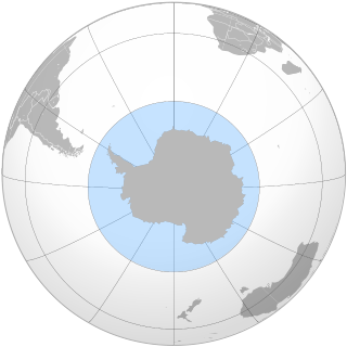
This is a list of extreme points in Antarctica.

This is a list of the extreme points of The Americas, the points that are farther north, south, east or west than any other location on the continent. The continent's southernmost point is often said to be Cape Horn, which is the southernmost point of the Chilean islands. The Americas cross 134° of longitude east to west and 124° of latitude north to south.

45×90 points Four points on Earth which are halfway between the geographical poles, the equator, the Prime Meridian, and the 180th meridian

The 45×90 points are the four points on Earth which are halfway between the geographical poles, the equator, the Prime Meridian, and the 180th meridian.

Farthest South A record held for most Southerly latitude reached, before the South Pole itself was reached.

Farthest South refers to the most southerly latitude reached by explorers before the conquest of the South Pole in 1911. Significant steps on the road to the pole were the discovery of lands south of Cape Horn in 1619, Captain James Cook's crossing of the Antarctic Circle in 1773, and the earliest confirmed sightings of the Antarctic mainland in 1820. From the late 19th century onward, the quest for Farthest South latitudes became in effect a race to reach the pole, which culminated in Roald Amundsen's success in December 1911.

Equator Intersection of a spheres surface with the plane perpendicular to the spheres axis of rotation and midway between the poles

Earth's Equator is a specific case of a planetary equator. It is about 40,075 km (24,901 mi) long, of which 78.8% lies across water and 21.3% over land.

Southern Ocean Ocean around Antarctica

The Southern Ocean, also known as the Antarctic Ocean or the Austral Ocean, comprises the southernmost waters of the World Ocean, generally taken to be south of 60° S latitude and encircling Antarctica. As such, it is regarded as the second-smallest of the five principal oceanic divisions: smaller than the Pacific, Atlantic, and Indian oceans but larger than the Arctic Ocean. Over the past 30 years, the Southern Ocean has been subject to rapid climate change, which has led to changes in the marine ecosystem.

This is a list of the extreme points of the Commonwealth of Nations — the points that are farther north, south, east or west, or higher or lower in elevation than any other location.

Borders of the oceans The limits of Earths oceanic waters

The borders of the oceans are the limits of Earth's oceanic waters. The definition and number of oceans can vary depending on the adopted criteria.

Solar eclipse of January 23, 1860

An annular solar eclipse occurred on January 23, 1860 during summer. A solar eclipse occurs when the Moon passes between Earth and the Sun, thereby totally or partly obscuring the image of the Sun for a viewer on Earth. An annular solar eclipse occurs when the Moon's apparent diameter is smaller than the Sun's, blocking most of the Sun's light and causing the Sun to look like an annulus (ring). An annular eclipse appears as a partial eclipse over a region of the Earth thousands of kilometres wide.

References

  1. Gould Coast US Geographic Survey.
  2. "Bay of Whales - former bay, Antarctica". Encyclopædia Britannica Online . Encyclopædia Britannica.
  3. "Mount Everest is more than two feet taller, China and Nepal announce". nationalgeographib.com.
  4. "Highest Mountain in the World". geology.com.
  5. "Chimborazo, el volcán de Ecuador más alto que el Everest (si se mide desde el centro de la Tierra)". BBC Mundo. 7 April 2016. Retrieved 8 April 2016.
  6. Klenke, Paul. "Distance to the Center of the Earth". Summit Post. Retrieved 4 July 2018.
  7. McIntyre, Loren (April 1987). "The High Andes". National Geographic. National Geographic Society. 171 (4): 422–460. (includes description and photos of Aucanquilcha summit road and mine)
  8. Assumpció Térmens (20 March 2006). "ICC – Semo Khardung" (PDF). viewfinderpanoramas.org. Institut Cartogràfic de Catalunya. Retrieved 5 February 2017.
  9. "Battle for the Highest Motorable Road". Motoroids. Retrieved 17 October 2017.
  10. Bennett, Suzy (October 2003). "Destination Guides – World's highest railway, Peru – Wanderlust Travel Magazine". Wanderlust Magazine. Archived from the original on 25 July 2011. Retrieved 10 October 2008.
  11. Ben Blanchard (16 September 2013). "China opens world's highest civilian airport". Reuters. Retrieved 16 September 2013.
  12. "Siachen: The world's highest cold war". CNN. 20 May 2002. Retrieved 2 May 2010.
  13. "Carrel refuge". summitpost.org.
  14. "Andes Website – Information about Ojos del Salado volcano, a high mountain in South America and the world's highest volcano" . Retrieved 18 January 2013.
  15. "The Highest Lake in the World" . Retrieved 7 September 2007.
  16. "ASTER measurement of supraglacial lakes in the Mount Everest region of the Himalaya: The main Khumbu Glacier is about 17 km long with elevations ranging from 4900m at the terminus to 7600m at the source....The 7600m to 8000m elevations are also depicted on numerous detailed topographic maps" . Retrieved 24 November 2008.
  17. "The Mystery of World's highest river and largest Canyon". Archived from the original on 21 September 2007. Retrieved 7 September 2007.
  18. "Island Superlatives" . Retrieved 7 September 2007.
  19. "TauTona, Anglo Gold – Mining Technology". SPG Media Group PLC. 1 January 2009. Retrieved 2 March 2009.
  20. "Transocean's Ultra-Deepwater Semisubmersible Rig Deepwater Horizon Drills World's Deepest Oil and Gas Well". Transocean. Archived from the original on 26 April 2010. Retrieved 7 June 2010.
  21. "Challenger Deep – the Mariana Trench" . Retrieved 30 July 2012.
  22. "Deepest Submarine Dive in History, Five Deeps Expedition Conquers Challenger Deep" (PDF). fivedeeps.com. Retrieved 13 May 2019.
  23. Klimchouck, Alexander. "The deepest cave in the world (Krubera Cave) became 6 m deeper". speleogenesis.info. Retrieved 10 August 2013.
  24. Jonathan Amos (12 December 2019). "Denman Glacier: Deepest point on land found in Antarctica". BBC . Retrieved 13 December 2019.
  25. Mathieu Morlighem; Eric Rignot; Tobias Binder; Donald Blankenship; Reinhard Drews; Graeme Eagles; Olaf Eisen; Fausto Ferraccioli; René Forsberg; Peter Fretwell; Vikram Goel; Jamin S. Greenbaum; Hilmar Gudmundsson; Jingxue Guo; Veit Helm; Coen Hofstede; Ian Howat; Angelika Humbert; Wilfried Jokat; Nanna B. Karlsson; Won Sang Lee; Kenichi Matsuoka; Romain Millan; Jeremie Mouginot; John Paden; Frank Pattyn; Jason Roberts; Sebastian Rosier; Antonia Ruppel; Helene Seroussi; Emma C. Smith; Daniel Steinhage; Bo Sun; Michiel R. van den Broeke; Tas D. van Ommen; Melchior van Wessem; Duncan A. Young (12 December 2019). "Deep glacial troughs and stabilizing ridges unveiled beneath the margins of the Antarctic ice sheet". Nature Geoscience . 13 (2): 132–137. doi:10.1038/s41561-019-0510-8. S2CID   209331991 . Retrieved 13 December 2019.
  26. Connolly, Kevin (17 June 2016). "Dead Sea drying: A new low-point for Earth". BBC. Retrieved 1 October 2018.
  27. 1 2 3 4 5 6 Garcia-Castellanos, Daniel; Lombardo, Umberto (2007). "Poles of Inaccessibility: A Calculation Algorithm for the Remotest Places on Earth" (PDF). Scottish Geographical Journal. Informa UK. 123 (3): 227–233. doi:10.1080/14702540801897809. ISSN   1470-2541. S2CID   55876083. Archived from the original (PDF) on 3 August 2014.
  28. Centre of Australia, States and Territories Archived 22 August 2008 at the Wayback Machine , Geoscience Australia
  29. "Where is Point Nemo?". NOAA. Retrieved 20 February 2015.
  30. Draft Logic – Google Maps Distance Calculator, accessed 4 September 2011
  31. "Flight Distance from Perth, Australia to Adelaide, Australia". travelmath.com.
  32. "The Most Isolated Cities of the World". cityextremes.com.
  33. "Great Circle Mapper". gcmap.com.
  34. "Discover The Furthest City on Earth From Wherever You Live". furthestcity.com.
  35. "What's the Farthest City and Country from Rosario, Argentina?". furthestcity.com.
  36. "What's the Farthest City and Country from Liu'an, Anhui, China?". furthestcity.com.
  37. "What's the Farthest City and Country from Cuenca, Ecuador?". furthestcity.com.
  38. "What's the Farthest City and Country from Shanghai, China?". furthestcity.com. Retrieved 25 September 2020.
  39. "What's the Farthest City and Country from Rancagua, Chile?". furthestcity.com.
  40. "What's the Farthest City and Country from Resistencia, Argentina?". furthestcity.com. Retrieved 25 September 2020.
  41. "What's the Farthest City and Country from Yantai, Shandong, China?". furthestcity.com. Retrieved 15 April 2020.
  42. "What's the Farthest City and Country from Coquimbo, Chile?". furthestcity.com. Retrieved 25 September 2020.
  43. "What's the Farthest City and Country from Bandung, Indonesia?". furthestcity.com. Retrieved 25 September 2020.
  44. "What's the Farthest City and Country from Salamanca, Spain?". furthestcity.com.
  45. Great Circle Mapper Access date: 2020-06-11
  46. MIT Technology Review – Computer scientists have found the longest straight line you could sail without hitting land
  47. (Map from gcmap)
  48. (Map from gcmap)
  49. Chabukswar, Rohan; Mukherjee, Kushal (9 April 2018). "Longest Straight Line Paths on Water or Land on the Earth". arXiv: 1804.07389 . Bibcode:2018arXiv180407389C.Cite journal requires |journal= (help)
  50. David Shultz (30 April 2018). "This ocean path will take you on the longest straight-line journey on Earth". Science Magazine.
  51. (Map from gcmap)
  52. (Map from gcmap)