
Keta is a town in the Volta Region of Ghana. It is the capital of the Keta Municipal District.
Ho is the capital city of the Ho Municipal District and the Volta Region of Ghana. The city lies between Mount Adaklu and Mount Galenukui or Togo Atakora Range, and is home to the Volta Regional Museum, a cathedral, and a prison. It was formerly the administrative capital of British Togoland now part of the Volta Region. The population of Ho Municipality according to the 2010 Population and Housing Census is 177,281 representing 8.4 percent of the region's total population. Females constitute 52.7 percent and males represent 47.3 percent. About 62 percent of the population resides in urban localities. The Municipality shares boundaries with Adaklu and Agotime-Ziope Districts to the South, Ho West District to the North and West and the Republic of Togo to the East. Its total land area is 2,361 square kilometers thus representing 11.5 percent of the region's total land area.
The Districts of Ghana are second-level administrative subdivisions of Ghana, below the level of region. There are 244 districts.

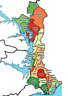
Volta Region, is one of Ghana's sixteen administrative regions, with Ho designated as its capital. It is located west of Republic of Togo and to the east of Lake Volta. Divided into 25 administrative districts, the region is multi-ethnic and multilingual, including groups such as the Ewe, the Guan, and the Akan peoples. The Guan peoples include the Lolobi, Likpe, Akpafu, Buem, and Nkonya people, et al.

Salaga is a town and is the capital of East Gonja district, a district in the Northern Region of north Ghana. Salaga has a 2012 settlement population of 25,472 people.
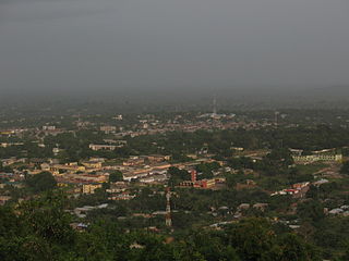
Kete Krachi is a town in the Krachi West District of the Oti Region of Ghana. Kete Krachi is the capital of the Krachi West District. It is in the West of the Oti region, and is adjacent to Lake Volta. Kete Krachi is connected by a ferry to the town of Kwadjokrom, and by road to Bimbila and Dambai. The town is also known for the Kete Krachi Secondary Technology. The school is a second cycle institution. Kete Krachi is the seventy-second most populous settlement in Ghana, in terms of population, with a population of 11,788 people.

Hohoe Municipal is one of the 25 administrative districts of the Volta Region of Ghana. It was carved out of the former Kpando District. It was established by the Legislative Instrument of 2012. The Municipality has a total land area of 1,172 km2, which is 5.6 percent of the land area of the region. It shares borders with the Republic of Togo on the east, forming part of Ghana's international border; on the southeast by the Afadzato district and southwest by Kpando Municipality; on the north with Jasikan district; and on the northwest with the Biakoye districts. Its capital, Hohoe, is about 78 kilometres from Ho, the regional capital and 220 km from Accra, the national capital. The population of Hohoe Municipality, according to the 2010 Population and Housing Census, is 167,016 representing 7.9 percent of the total population of the Volta Region. It comprises 52.1 percent females and 47.9 percent males

The Jasikan District is one of the twenty-five (25) districts in the Volta Region. Jasikan district capital and administrative centre is Jasikan.
The Kpando Municipal District is one of the twenty-five (25) districts in the Volta Region. Kpando Municipal district capital and administrative centre is Kpandu.
The South Dayi District is one of the twenty-five (25) districts in the Volta Region of Ghana. The South Dayi district capital and administrative centre is Kpeve.

North Dayi is one of the constituencies represented in the Parliament of Ghana. It elects one Member of Parliament (MP) by the first past the post system of election. North Dayi is located in the Anfoega district of the Volta Region of Ghana.
Joseph Zaphenat Amenowode is a Ghanaian politician and academic. He was the Member of Parliament for Hohoe South and was the Minister for the Volta Region of Ghana from January 2009 until his dismissal on 6 March 2012. He has worked as a university lecturer prior to going into politics.
Anloga is a town in Keta District of the Volta Region in southeast Ghana. It lies east of the Volta River and just south of the Keta Lagoon. Anloga is the forty-seventh most populous in Ghana, in terms of population, with a population of 35,933 people.
Dodi Papase is a town in the Volta Region of Ghana. With a population of approximately 5,254 ,Dodi Papase is the second-most-populous city in Kadjebi District in the Volta region of Ghana. It is located in Eastern Ghana on the banks of the Wawa River and is known for the Dodi Papase Community Secondary School, a second cycle institution.
Kpandai is a town and is the capital of Kpandai district, a district in the Northern Region of north Ghana. Kpandai had a 2012 settlement population of 11,239 people.

Akatsi College of Education (AKATSICO) is a teacher training college located at Akatsi in the Volta Region of Ghana. It was established on 1 October 1963. Its motto is "Quality teacher education in a changing society," and the college is home to more than 700 students.
Bishop Herman College, sometimes abbreviated to BIHECO, is a boys-only second-cycle institution located at Kpando in the Volta Region of Ghana.
Ahamansu, also known as Ahamasu or Ahamanso, is a farming community in the Kadjebi District of the Volta Region, Ghana. Ahamansu is one of six towns and area councils in the district.
Kpando is one of the constituencies represented in the Parliament of Ghana. It elects one Member of Parliament (MP) by the first past the post system of election. The Kpando constituency is located in the Kpando District of the Volta Region of Ghana.
Kpando Secondary School is a second cycle co-ed institution in the Kpando district of the Volta Region of Ghana.


