
The following is an alphabetical list of articles related to the Philippine capital region of Metro Manila .
The following is an alphabetical list of articles related to the Philippine capital region of Metro Manila .

This section is empty.You can help by adding to it.(April 2017) |

Metropolitan Manila, officially the National Capital Region (NCR), is the seat of government and one of three defined metropolitan areas in the Philippines. It is composed of 16 cities: the city of Manila, Quezon City, Caloocan, Las Piñas, Makati, Malabon, Mandaluyong, Marikina, Muntinlupa, Navotas, Parañaque, Pasay, Pasig, San Juan, Taguig, and Valenzuela, as well as the municipality of Pateros. The region encompasses an area of 619.57 square kilometers (239.22 sq mi) and a population of 12,877,253 as of 2015. It is the second most populous and the most densely populated region of the Philippines. It is also the 9th most populous metropolitan area in Asia and the 5th most populous urban area in the world.

Rizal, officially the Province of Rizal, is a province in the Philippines located in the Calabarzon region, 16 kilometres (9.9 mi) east of Manila. The province is named after José Rizal, one of the main national heroes of the Philippines. Rizal is bordered by Metro Manila to the west, Bulacan to the north, Quezon to the east and Laguna to the southeast. The province also lies on the northern shores of Laguna de Bay, the largest lake in the country. Rizal is a mountainous province perched on the western slopes of the southern portion of the Sierra Madre mountain range.
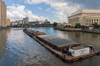
The Pasig River is a river in the Philippines that connects Laguna de Bay to Manila Bay. Stretching for 25 kilometres (15.5 mi), it bisects the Philippine capital of Manila and its surrounding urban area into northern and southern halves. Its major tributaries are the Marikina River and San Juan River. The total drainage basin of Pasig River, including the basin of Laguna de Bay, covers 4,678 square kilometres (1,806 sq mi).

Pasig, officially the City of Pasig, or simply known as Pasig City, is a 1st class highly urbanized city in Metropolitan Manila, Philippines. According to the 2015 census, it has a population of 755,300 people.
The Legislative Districts of Rizal are the representations of the province of Rizal in the various national legislatures of the Philippines. The province is currently represented in the lower house of the Congress of the Philippines through its first and second congressional districts.
Barangka is one of sixteen barangays in Marikina, Philippines and one of the barangays in 1st District of Marikina. It is also one of the oldest barangay founded in Marikina.

Circumferential Road 5, more commonly known as C-5 Road or C-5, is a network of roads and bridges that altogether forms a major route that transverses in Metro Manila, in the National Capital Region of the Philippines. It is also known officially as Carlos P. Garcia Avenue, and as National Route 11 (N11), National Route 128 (N128) and National Route 129 (N129) in the National Route Numbering System implemented in 2014. Expressway portions, part of the North Luzon Expressway Mindanao Avenue and Karuhatan Link, are numbered Expressway 5 (E5).
Ayala Malls is a real-estate subsidiary of Ayala Land, an affiliate of Ayala Corporation. Founded in 1988, Ayala Malls own a chain of large shopping malls, all located in the Philippines. Ayala Malls is the one of the largest shopping mall retailer in the Philippines, along with SM Supermalls and Robinsons Malls.

The transportation system in Metro Manila is currently inadequate to accommodate the mobility and other basic needs of an densely populated metropolis, the result of many factors and problems that the government has failed to provide or address. Metro Manila exists in a state of near-permanent gridlock, with people and goods trapped by the very transportation system that is supposed to move them quickly and efficiently.
The Pasig River Expressway (PAREX) is a proposed expressway in Metro Manila, Philippines that will skirt the banks of the Pasig River and connect the City of Manila with the province of Rizal. The expressway is being planned to decongest traffic and to cure the pollution of the Pasig River.
Numerous events and festivals are held annually in Metro Manila. They include:

Kalayaan Avenue is a major east–west route in Makati, Metro Manila, Philippines. For most of its length, it runs parallel to J.P. Rizal Avenue to the north from East Rembo near Fort Bonifacio to Singkamas Village by the border with San Andres, Manila. It is interrupted by Bel-Air Village between Amapola Street and Epifanio de los Santos Avenue (EDSA). The avenue is designated as a component of Radial Road 4 (R-4) of the Metro Manila Arterial Road System.

The following outline is provided as an overview of and topical guide to Metro Manila:

Radial Road 4, more commonly referred to as R-4, is a proposed network of roads and bridges that altogether would form the fourth radial road of Manila in the Philippines. The road would link the City of Manila with Makati and Pasig in the south and east, leading out of Metro Manila into the province of Rizal. R-4 parallels Radial Road 5 (R-5) on the south bank of the Pasig River. At present, only certain portions of the road are complete.
National Route 59 (N59) is a primary national route that forms part of the Philippine highway network, running from Antipolo, Rizal to Cubao, Quezon City, Metro Manila.