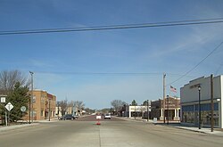
Stratford, Texas

Last updated

Stratford, Texas
Stratford, Texas.jpg
Stratford, 2006
TXMap-doton-Stratford.PNG
Location of Stratford, Texas
Sherman County Stratford.svg
Coordinates: 36°20′15″N102°04′34″W / 36.33750°N 102.07611°W / 36.33750; -102.07611
CountryUnited States
State Texas
County Sherman
Settledc.1885
Named for Stratford Hall
Area
[1]
  Total
2.31 sq mi (5.98 km2)
  Land2.31 sq mi (5.98 km2)
  Water0.00 sq mi (0.00 km2)
Elevation
[2]
3,694 ft (1,126 m)
Population
 (2020)
  Total
1,939
  Density840/sq mi (320/km2)
Time zone UTC−6 (Central (CST))
  Summer (DST) UTC−5 (CDT)
ZIP code
79084
Area code 806
FIPS code 48-70544 [3]
GNIS feature ID2411988 [2]
Website www.stratfordtx.com

Stratford is a town and county seat of Sherman County, Texas, United States. Its population was 1,939 at the 2020 Census, [4] down from 2,017 in 2010. [5]

Contents

History

Stratford was first settled around 1885, when a man named Aaron Norton bought 100 parcels of land from the Chicago, Rock Island and Gulf Railway. His manager, Walter Colton, named it for Stratford Hall, the childhood home of Robert E. Lee, whom he admired. A post office was established in 1900. In July 1901, Stratford was voted county seat, replacing Coldwater. In 1928, the Panhandle and Santa Fe Railway was connected to Stratford. The town was incorporated at some point before 1940. [6]

Geography

According to the United States Census Bureau, the city has a total area of 2.0 square miles (5.3 km2), all land.

Stratford is situated in the Llano Estacado. The Rita Blance National Grasslands are due west of the town. [7]

Climate

Stratford has a semiarid climate (BSk) with long, hot summers and short, cool, and somewhat snowy winters.

A dust storm is approaching Stratford on April 18, 1935. Dust storm approaching Stratford, Texas.jpg
A dust storm is approaching Stratford on April 18, 1935.
Climate data for Stratford, Texas (1981–2010)
MonthJanFebMarAprMayJunJulAugSepOctNovDecYear
Mean daily maximum °F (°C)48.3
(9.1)
51.5
(10.8)
59.9
(15.5)
69.2
(20.7)
78.0
(25.6)
87.1
(30.6)
91.5
(33.1)
89.4
(31.9)
82.2
(27.9)
70.8
(21.6)
58.5
(14.7)
47.6
(8.7)
69.5
(20.8)
Mean daily minimum °F (°C)19.7
(−6.8)
22.1
(−5.5)
29.3
(−1.5)
37.6
(3.1)
48.1
(8.9)
58.0
(14.4)
62.9
(17.2)
61.8
(16.6)
53.3
(11.8)
40.5
(4.7)
28.7
(−1.8)
20.2
(−6.6)
40.2
(4.6)
Average precipitation inches (mm)0.53
(13)
0.45
(11)
1.26
(32)
1.24
(31)
2.24
(57)
2.21
(56)
2.24
(57)
2.59
(66)
1.68
(43)
1.29
(33)
0.69
(18)
0.72
(18)
17.15
(436)
Average snowfall inches (cm)5.4
(14)
2.9
(7.4)
4.3
(11)
1.4
(3.6)
0.1
(0.25)
0.0
(0.0)
0.0
(0.0)
0.0
(0.0)
0.0
(0.0)
0.2
(0.51)
2.0
(5.1)
5.1
(13)
21.4
(54)
Source: NOAA [8]

Demographics

Historical population
CensusPop.Note
1910 520
1920 472−9.2%
1930 87385.0%
1940 8770.5%
1950 1,38557.9%
1960 1,380−0.4%
1970 2,13955.0%
1980 1,917−10.4%
1990 1,781−7.1%
2000 1,99111.8%
2010 2,0171.3%
2020 1,939−3.9%
U.S. Decennial Census [9]

2020 census

Stratford racial composition [4]
(NH = Non-Hispanic) [a]
RaceNumberPercentage
White (NH)82242.39%
Black or African American (NH)100.52%
Native American or Alaska Native (NH)40.21%
Asian (NH)10.05%
Some Other Race (NH)50.26%
Mixed/multiracial (NH)512.63%
Hispanic or Latino 1,04653.95%
Total1,939

As of the 2020 United States census, there were 1,939 people, 702 households, and 554 families residing in the city.

2000 census

At the 2000 Census, 1,991 people, 722 households, and 535 families were living in the city. The population density was 980.2 inhabitants per square mile (378.5/km2). The 794 housing units had an average density of 390.9 per square mile (150.9/km2). The racial makeup of the city was 83.02% White, 0.30% African American, 0.65% Native American, 0.05% Asian, 14.41% from other races, and 1.56% from two or more races. Hispanics or Latinos of any race were 30.44%. [3]

Of the 722 households, 39.2% had children under 18 living with them, 64.1% were married couples living together, 6.9% had a female householder with no husband present, and 25.9% were not families. About 24.4% of households were one person and 11.4% were one person 65 or older. The average household size was 2.68 and the average family size was 3.21.

The age distribution was 30.5% under 18, 6.6% from 18 to 24, 26.0% from 25 to 44, 21.4% from 45 to 64, and 15.5% 65 or older. The median age was 36 years. For every 100 females, there were 98.3 males. For every 100 females age 18 and over, there were 92.8 males.

The median household income was $32,656 and the median family income was $37,955. Males had a median income of $27,113 versus $19,524 for females. The per capita income for the city was $16,790. About 11.2% of families and 13.8% of the population were below the poverty line, including 18.7% of those under age 18 and 13.8% of those age 65 or over.

Transportation

Stratford is at the intersection of US Routes 54 and 287, and is the western terminus of Texas State Highway 15. [7]

The nearest major airport, Liberal Mid-America Regional Airport, is 82 miles and two states away in Liberal, Kansas, although Rick Husband Amarillo International Airport is only slightly further away, at 91 miles. [12]

Education

The city of Stratford is served by the Stratford Independent School District, and is home to Stratford High School.

Notes

  1. Note: the US Census treats Hispanic/Latino as an ethnic category. This table excludes Latinos from the racial categories and assigns them to a separate category. Hispanics/Latinos can be of any race. [10] [11]

Related Research Articles

<span class="mw-page-title-main">Wharton County, Texas</span> County in Texas, United States

Wharton County is a county located in the U.S. state of Texas. As of the 2020 census, its population was 41,570. Its county seat is Wharton. The county was named for brothers William Harris Wharton and John Austin Wharton.

<span class="mw-page-title-main">Tyler County, Texas</span> County in Texas, United States

Tyler County is a county located in the U.S. state of Texas. It is in East Texas and its seat is Woodville. As of the 2020 census, its population was 19,798. Tyler County is named for John Tyler, the 10th President of the United States. Despite its name, Tyler County does not contain the city of Tyler, Texas; the latter is located about 140 miles to the north in Smith County.

<span class="mw-page-title-main">Sherman County, Texas</span> County in Texas, United States

Sherman County is a county located in the U.S. state of Texas. As of the 2020 census, its population was 2,782. Its county seat is Stratford. The county was created in 1876 and organized in 1889. It is named for Sidney Sherman, who fought in the Texas Revolution. Though both Sherman County and Sherman, Texas, are named for the same person, the city of Sherman is located in Grayson County, about 430 miles to the southeast.

<span class="mw-page-title-main">Chambers County, Texas</span> County in Texas, United States

Chambers County is a county in the U.S. state of Texas. As of the 2020 census, its population was 46,571. The county seat is Anahuac. Chambers County is one of the nine counties that comprise Greater Houston, the Houston–The Woodlands–Sugar Land metropolitan statistical area.

<span class="mw-page-title-main">Aransas County, Texas</span> County in Texas, United States

Aransas County is a county located in the U.S. state of Texas. It is in South Texas and its county seat is Rockport.

<span class="mw-page-title-main">Greendale, Missouri</span> City in Missouri, United States

Greendale is a city in St. Louis County, Missouri, United States. The population was 651 at the 2010 census.

<span class="mw-page-title-main">Solis, Texas</span> Census-designated place in Texas, United States

Solis is a census-designated place (CDP) in Cameron County, Texas, United States. The population was 722 at the 2020 census. It is part of the Brownsville–Harlingen Metropolitan Statistical Area.

<span class="mw-page-title-main">Stowell, Texas</span> Census-designated place in Texas, United States

Stowell is an unincorporated community and census-designated place (CDP) in Chambers County, Texas, United States. The population was 1,743 at the 2020 census.

<span class="mw-page-title-main">Garden Ridge, Texas</span> City in Texas, United States

Garden Ridge is a city in Comal County, Texas, United States, incorporated in 1972. The population was 4,186 at the 2020 census, up from 3,259 at the 2010 census. It is part of the San Antonio metropolitan statistical rea.

<span class="mw-page-title-main">Dickens, Texas</span> City in Texas, United States

Dickens is a city in and the county seat of Dickens County, Texas, United States. The population was 219 at the 2020 census, down from 286 at the 2010 census.

<span class="mw-page-title-main">Asherton, Texas</span> City in Texas, United States

Asherton is a city in Dimmit County, Texas, United States. The population was 722 at the 2020 census, down from 1,084 at the 2010 census. U.S. Highway 83 passes through Asherton.

Bayou Vista is a city in Galveston County, Texas, United States. The population was 1,763 at the 2020 census. It received severe damage from Hurricane Ike on September 13, 2008.

<span class="mw-page-title-main">Hamilton, Texas</span> City in Texas, United States

Hamilton is a city in and the county seat of Hamilton County, Texas, United States, located in the state's central region. Its population was 2,895 at the 2020 census.

<span class="mw-page-title-main">Mertzon, Texas</span> City in Irion County, Texas, United States

Mertzon is a city in and the county seat of Irion County, Texas, United States. Its population was 747 according to the 2020 census. It is part of the San Angleo, metropolitan statistical area.

Browndell is a city in Jasper County, Texas, United States. The population was 160 at the 2020 census.

<span class="mw-page-title-main">Jayton, Texas</span> City in Texas, United States

Jayton is a city in and the county seat of Kent County, Texas, United States. It is located in the northeastern portion of the county, and the population was 511 as of the 2020 census.

Beckville is a city in Panola County, in the U.S. state of Texas. The population was 722 at the 2020 census.

<span class="mw-page-title-main">West Livingston, Texas</span> CDP in Texas

West Livingston is a census-designated place (CDP) in western Polk County, Texas, United States, located along the eastern shore of Lake Livingston 6 miles (9.7 km) west of central Livingston. The population was 8,156 at the 2020 census.

<span class="mw-page-title-main">Stratford, Iowa</span> City in Iowa, United States

Stratford is a city in Hamilton and Webster counties in the U.S. state of Iowa. The population was 707 at the time of the 2020 census.

<span class="mw-page-title-main">San Diego, Texas</span> City in Texas, United States

San Diego is a city in Duval and Jim Wells counties, Texas, United States. The population was 3,748 at the 2020 census and 4,488 at the 2010 census. It is located primarily in Duval County, of which it is the county seat.

References

  1. "2019 U.S. Gazetteer Files". United States Census Bureau. Retrieved August 7, 2020.
  2. 1 2 U.S. Geological Survey Geographic Names Information System: Stratford, Texas
  3. 1 2 "U.S. Census website". United States Census Bureau . Retrieved January 31, 2008.
  4. 1 2 "P2: Hispanic or Latino, and Not Hispanic or Latino by Race". Census Bureau Table. Retrieved May 20, 2022.
  5. "Find a County". National Association of Counties. Retrieved June 7, 2011.
  6. Association, Texas State Historical. "Stratford, TX". Texas State Historical Association. Retrieved July 15, 2024.
  7. 1 2 "Rita Blanca National Grasslands to Stratford, Texas". Google Maps. Retrieved February 17, 2021.
  8. "NOWData - NOAA Online Weather Data". National Oceanic and Atmospheric Administration . Retrieved May 5, 2013.
  9. "Census of Population and Housing". Census.gov. Retrieved June 4, 2015.
  10. https://www.census.gov/ [ not specific enough to verify ]
  11. "About the Hispanic Population and its Origin". www.census.gov. Retrieved May 18, 2022.
  12. "Major Airports near Stratford, Texas". Travelmath. Archived from the original on April 7, 2022. Retrieved February 17, 2021.