Payyannur is a Taluk in Kannur district in the state of Kerala in India. On 10 March 2018, Kerala Chief Minister Pinarayi Vijayan inaugurated Payyannur as the fifth taluk in the district. This taluk comprises 22 villages including 16 de-linked from the Taliparamba taluk and six from the Kannur taluk. The town is situated on the banks of Perumba River.

Ajanur is a grama panchayat and also a village of the same name in Kasargode district, Kerala state, India. It is the fifth largest town in Kasaragod district.

Manjeshwar, also known as Manjeshwaram is a town at the northern tip of the India state of Kerala. It is situated at a distance of 584 kilometres (360 mi) from the state capital Thiruvanathapuram, 610 Km from Parassala, 670 Km from Kanyakumari (Agasteeshwaram) and 27 kilometres (20 mi) south of Mangalore city in neighboring Karnataka. It is a coastal town in Kasaragod district.

Palavayal is a village in the eastern hilly areas of Kasaragod district in the Indian state of Kerala.Palavayal consists of small villages like Odakkolly, Chavaragiri and Malankadavu. Palavayal is separated from another town Pulingome which is in Kannur District.

Valiyaparamba is a coastal island in Hosdurg taluk, Kasaragod district, Kerala state, India.

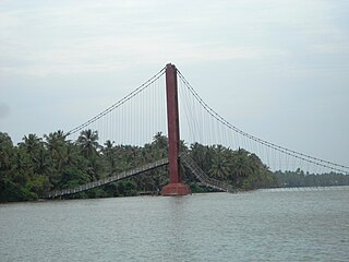
Kavvayi is a group of small islands, near Payyannur in the Kannur district of Kerala state in India. The island is connected to Payyannur by a small bridge on the Kavvayi River. The population is mainly Muslim.

Uppala is a major town in Kasaragod district, Kerala, India. It is a satellite town developing 22 km north to Kasaragod city. Uppala is the one of the fastest growing urban settlements along the National Highway 66. It is well known as a trade hub in the district.

Kasaragod District is one of the 14 districts in the southern Indian state of Kerala. Kasaragod became part of Kannur district following the reorganisation of states due to predominance of Malayalam speakers. Kasaragod was declared as a district on 24 May 1984.

Cherupuzha is one of the main town in kannur district. Cherupuzha town, which is the headquarters of the Cherupuzha Panchayat, is located about 30 kilometers east of Payyannur and 35 kilometers west of Nileshwaram and 58 kilometres north of Kannur city.
The Malabar Express is a train service in India, named after the Malabar coast, the south-western coastal region of India from Mangalore Central to Thiruvananthapuram Central. As the name suggests, it connects the two ends of the Malabar region. The train has one of the longest running time between Mangalore and Thiruvananthapuram Central. It Shares its Rake with 16603/04 Maveli Express, 12601/02 Mangalore Central-Chennai Central Superfast Mail and 22637/38 West Coast Super Fast Express.Malabar Express is one of the most popular trains in Kerala.

Ramanthali is a village in Kannur district in the Indian state of Kerala. It boasts the gateway for Indian Naval Academy in Ezhiamala.

Thirumeni is a village in Kannur district in the Kerala state of India.The village consists majorly of immigrants from various part of Travancore(Kottayam, Pathanamthitta and Idukki Districts) who settled in the famed Malabar migration period. Most of the inhabitants of the village reside in the valley of three major hills by name Chathammangalam Theruvamala alias Alumbumala, Kottathalachimala and Thevarkunnumala. Thirumeni is a small junction with a few government institutions, religious institutions and small shops in int. and is subdivided into smaller villages like Kokkadave, Prapoyil, Chathamangalam (Kannur), Thabore, Muthuvom, Korali, Chattivayal, Thannichal, Paruthikallu etc.

Bandadka is a Small Town in Kasaragod district in the state of Kerala, India. Kottakkal, which means near to Kotta(the fort) became Bandadka, which is a kannada version of kottakkal,ie,Bandh(Fort)+adka(Near). It comes under Kuttikol Panchayath. It belongs to North Kerala Division. It is located 37 KM towards East from District head quarters Kasaragod and 592 KM from State capital Thiruvananthapuram.

Chittarikkal is a small town in Kasaragod district in the state of Kerala, India. Chittarikkal town is between Vellarikundu and Cherupuzha on Odayanchal Cherupuzha road.

Periya is a little township in Kasaragod District, India.
Chavaragiri is a small rural village in Parappa Taluk in Kasaragod District of Kerala State, India. It comes under Palavayal Village in East Eleri Grama Panchayath. It is located 43 km towards South from Payyanur. The village is approximately 543 km from the State capital Thiruvananthapuram, Kerala.
Rajiv Gandhi Pharmacy College, Trikaripur is a professional college of Trikaripur near Payyanur in Kerala, India.

Mulleria is a Major town and Located in Karadka Panchayath, Kasaragod district in Kerala, India.


