List of California county high points

Last updated
The location of California in the United States California in United States.svg
The location of California in the United States
Relief map of California.png
Blue pog.svg
Blue pog.svg
Green pog.svg
Green pog.svg
Green pog.svg
Green pog.svg
Green pog.svg
Green pog.svg
Yellow pog.svg
Yellow pog.svg
Yellow pog.svg
Yellow pog.svg
Yellow pog.svg
Yellow pog.svg
Yellow pog.svg
Yellow pog.svg
Yellow pog.svg
Yellow pog.svg
Yellow pog.svg
Yellow pog.svg
Yellow pog.svg
Yellow pog.svg
Yellow pog.svg
Yellow pog.svg
Yellow pog.svg
Orange pog.svg
Orange pog.svg
Orange pog.svg
Orange pog.svg
Orange pog.svg
Orange pog.svg
Orange pog.svg
Orange pog.svg
Orange pog.svg
Orange pog.svg
Orange pog.svg
Orange pog.svg
Orange pog.svg
Orange pog.svg
Orange pog.svg
Orange pog.svg
Orange pog.svg
Red pog.svg
Red pog.svg
Red pog.svg
Red pog.svg
Red pog.svg
Red pog.svg
Red pog.svg
Red pog.svg
Red pog.svg
Purple pog.svg
Purple pog.svg
Purple pog.svg
Purple pog.svg
Purple pog.svg
Locations of the highest point in each county, with color corresponding to height.

This is a list of 58 counties of the U.S. State of California by their points of highest elevation . 6 of the 50 highest county high points in the United States are in California. Mount Whitney, located in Inyo and Tulare counties, is the highest point in California as well as the highest point in the contiguous United States at 14,505 feet (4,421 m). [1]

Contents

Because of the wide variety of mountain ranges in California, the state has become a common destination for highpointers and peakbaggers. As of May 2024, at least 45 different climbers have summited all 58 county high points in California. [2]

Some of these high points, such as Laveaga Peak and South Butte among others, are located on private or protected land and are typically not allowed to be summited. However, some climbers have successfully organized group hikes with the permission of the land owner, [3] while others simply trespass on the land after dark in order to reach the summit. While peakbagger.com and other similar highpointing websites explicitly forbid trespassing on private and protected land, trip reports submitted to these sites would suggest that many climbers do this anyway. [4]

California county high points

California county high points

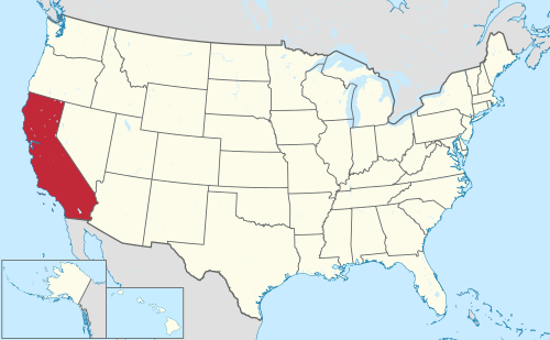
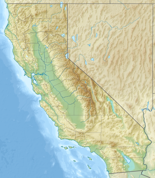
County Rank High point Region Elevation Prominence Isolation Location
Inyo County 1 Mount Whitney [5] [6] Sierra Nevada 14,505 feet (4,421 m)10,079 feet (3,072 m)1,646.4 miles (2,649.7 km) 36°34′43″N118°17′31″W / 36.578581°N 118.291995°W / 36.578581; -118.291995 (1. Mount Whitney)
Tulare County
Mono County 3 White Mountain Peak [5] [7] White Mountains 14,252 feet (4,344 m)7,195 feet (2,193 m)67.5 miles (108.6 km) 37°38′03″N118°15′21″W / 37.634144°N 118.255718°W / 37.634144; -118.255718 (3. White Mountain Peak)
Fresno County 4 North Palisade [5] [8] Sierra Nevada 14,249 feet (4,343 m)9,495 feet (2,894 m)32.2 miles (51.8 km) 37°05′39″N118°30′52″W / 37.09419°N 118.514467°W / 37.09419; -118.514467 (4. North Palisade)
Siskiyou County 5 Mount Shasta [5] [9] Cascades 14,170 feet (4,319 m)9,760 feet (2,975 m)334.7 miles (538.7 km) 41°24′32″N122°11′42″W / 41.408982°N 122.194926°W / 41.408982; -122.194926 (5. Mount Shasta)
Madera County 6 Mount Ritter [5] [10] Sierra Nevada 13,150 feet (4,008 m)3,957 feet (1,206 m)30.0 miles (48.2 km) 37°41′21″N119°11′58″W / 37.689058°N 119.199557°W / 37.689058; -119.199557 (6. Mount Ritter)
Tuolumne County 7 Mount Lyell [5] [11] Sierra Nevada 13,114 feet (3,997 m)1,893 feet (577 m)5.2 miles (8.4 km) 37°44′22″N119°16′18″W / 37.73943°N 119.27159°W / 37.73943; -119.27159 (7. Mount Lyell (California))
Mariposa County 8 Parsons Peak's northwest ridge [5] [12] Sierra Nevada 12,047 feet (3,672 m)0 feet (0 m)0 miles (0 km) 37°46′41″N119°18′34″W / 37.778175°N 119.309488°W / 37.778175; -119.309488 (8. Parsons Peak)
San Bernardino County 9 San Gorgonio Mountain [5] [13] San Bernardino Mountains 11,503 feet (3,506 m)8,294 feet (2,528 m)162.5 miles (261.5 km) 34°05′57″N116°49′29″W / 34.099162°N 116.824853°W / 34.099162; -116.824853 (9. San Gorgonio Mountain)
Alpine County 10 Sonora Peak [5] [14] Sierra Nevada 11,467 feet (3,495 m)1,818 feet (554 m)4.7 miles (7.6 km) 38°21′14″N119°37′32″W / 38.353852°N 119.625556°W / 38.353852; -119.625556 (10. Sonora Peak)
El Dorado County 11 Freel Peak [5] [15] Sierra Nevada 10,889 feet (3,319 m)3,146 feet (959 m)22.9 miles (36.9 km) 38°51′27″N119°54′00″W / 38.857499°N 119.900095°W / 38.857499; -119.900095 (11. Freel Peak)
Riverside County 12 San Jacinto Peak [5] [16] San Jacinto Mountains 10,843 feet (3,305 m)8,320 feet (2,536 m)20.3 miles (32.7 km) 33°48′53″N116°40′46″W / 33.814785°N 116.679477°W / 33.814785; -116.679477 (12. San Jacinto Peak)
Shasta County 13 Lassen Peak [5] [17] Cascades 10,459 feet (3,188 m)5,230 feet (1,594 m)71.4 miles (114.9 km) 40°29′17″N121°30′18″W / 40.488165°N 121.504966°W / 40.488165; -121.504966 (13. Lassen Peak)
Los Angeles County 14 Mount San Antonio [5] [18] San Bernardino Mountains 10,069 feet (3,069 m)6,230 feet (1,899 m)42.5 miles (68.4 km) 34°17′21″N117°38′47″W / 34.28916°N 117.64636°W / 34.28916; -117.64636 (14. Mount San Antonio)
Modoc County 15 Eagle Peak [5] [19] Warner Mountains 9,895 feet (3,016 m)4,350 feet (1,326 m)87.4 miles (140.6 km) 41°17′01″N120°12′03″W / 41.283534°N 120.200804°W / 41.283534; -120.200804 (15. Eagle Peak (Modoc County, California))
Amador County 16 Thunder Mountain [5] [20] Sierra Nevada 9,423 feet (2,872 m)377 feet (115 m)1.3 miles (2.1 km) 38°40′36″N120°05′08″W / 38.67672°N 120.08548°W / 38.67672; -120.08548 (16. Thunder Mountain (Amador County, California))
Tehama County 17 Brokeoff Mountain [5] [21] Cascades 9,239 feet (2,816 m)915 feet (279 m)3.5 miles (5.7 km) 40°26′44″N121°33′35″W / 40.445564°N 121.559585°W / 40.445564; -121.559585 (17. Brokeoff Mountain)
Nevada County 18 Mount Lola [5] [22] Sierra Nevada 9,144 feet (2,787 m)2,083 feet (635 m)22.1 miles (35.5 km) 39°25′58″N120°21′54″W / 39.4329°N 120.36504°W / 39.4329; -120.36504 (18. Mount Lola)
Placer County 19 Mount Baldy's west ridge [5] [23] Sierra Nevada 9,035 feet (2,754 m)9.8 feet (3 m)0.31 miles (0.5 km) 39°16′46″N120°00′21″W / 39.27958°N 120.00584°W / 39.27958; -120.00584 (19. Mount Baldy (Nevada))
Trinity County 20 Mount Eddy [5] [24] Klamath Mountains 9,029 feet (2,752 m)5,105 feet (1,556 m)13.3 miles (21.4 km) 41°19′11″N122°28′45″W / 41.319728°N 122.479094°W / 41.319728; -122.479094 (20. Mount Eddy)
Sierra County 21 Mount Lola's north ridge [5] [25] Sierra Nevada 8,855 feet (2,699 m)52 feet (16 m)1.2 miles (1.9 km) 39°26′59″N120°21′50″W / 39.44962°N 120.36399°W / 39.44962; -120.36399 (21. Mount Lola)
Ventura County 22 Mount Pinos [5] [26] San Bernardino Mountains 8,839 feet (2,694 m)4,806 feet (1,465 m)83.0 miles (133.5 km) 34°48′46″N119°08′44″W / 34.81283°N 119.14542°W / 34.81283; -119.14542 (22. Mount Pinos)
Kern County 23 Sawmill Mountain [5] [27] San Bernardino Mountains 8,830 feet (2,690 m)440 feet (134 m)1.2 miles (2.0 km) 34°48′49″N119°10′00″W / 34.81365°N 119.16668°W / 34.81365; -119.16668 (23. Sawmill Mountain)
Lassen County 24 Hat Mountain [5] [28] Warner Mountains 8,747 feet (2,666 m)1,184 feet (361 m)6.3 miles (10.2 km) 41°08′49″N120°07′33″W / 41.147058°N 120.125778°W / 41.147058; -120.125778 (24. Hat Mountain (California))
Plumas County 25 Mount Ingalls [5] [29] Sierra Nevada 8,376 feet (2,553 m)2,792 feet (851 m)27.5 miles (44.3 km) 39°59′39″N120°37′39″W / 39.994141°N 120.62745°W / 39.994141; -120.62745 (25. Mount Ingalls (California))
Calaveras County 26 Corral Hollow Hill [5] [30] Sierra Nevada 8,170 feet (2,490 m)207 feet (63 m)1.3 miles (2.1 km) 38°28′59″N120°04′36″W / 38.483136°N 120.076584°W / 38.483136; -120.076584 (26. Coral Hollow Hill)
Glenn County 27 Black Butte [5] [31] Northern Coast Range 7,451 feet (2,271 m)2,434 feet (742 m)19.3 miles (31.1 km) 39°43′36″N122°52′21″W / 39.726751°N 122.872553°W / 39.726751; -122.872553 (27. Black Butte (Glenn County, California))
Butte County 28 Butte County High Point [5] [32] Sierra Nevada 7,123 feet (2,171 m)0 feet (0 m)0 miles (0 km) 40°07′33″N121°24′17″W / 40.125857°N 121.404824°W / 40.125857; -121.404824 (28. Butte County High Point, California)
Colusa County 29 Snow Mountain [5] [33] Northern Coast Range 7,060 feet (2,152 m)2,497 feet (761 m)24.2 miles (39.0 km) 39°23′01″N122°45′08″W / 39.383509°N 122.752151°W / 39.383509; -122.752151 (29. Snow Mountain (Colusa County, California))
Lake County
Humboldt County 31 Salmon Mountain [5] [34] Klamath Mountains 6,959 feet (2,121 m)2,005 feet (611 m)17.6 miles (28.3 km) 41°11′00″N123°24′39″W / 41.183229°N 123.41076°W / 41.183229; -123.41076 (31. Salmon Mountain (California))
Mendocino County 32 Anthony Peak [5] [35] Northern Coast Range 6,959 feet (2,121 m)1,512 feet (461 m)9.4 miles (15.1 km) 39°50′46″N122°57′52″W / 39.846239°N 122.964572°W / 39.846239; -122.964572 (32. Anthony Peak (California))
Santa Barbara County 33 Big Pine Mountain [5] [36] San Bernardino Mountains 6,820 feet (2,080 m)2,200 feet (670 m)19.4 miles (31.3 km) 34°41′50″N119°39′11″W / 34.69716°N 119.65317°W / 34.69716; -119.65317 (33. Big Pine Mountain)
San Diego County 34 Hot Springs Mountain [5] [37] Peninsular Range 6,535 feet (1,992 m)2,612 feet (796 m)15.6 miles (25.1 km) 33°18′55″N116°34′47″W / 33.315157°N 116.579795°W / 33.315157; -116.579795 (34. Hot Springs Mountain)
Del Norte County 35 Bear Mountain's southwest slope [5] [38] Klamath Mountains 6,404 feet (1,952 m)0 feet (0 m)0 miles (0 km) 41°47′46″N123°40′20″W / 41.796054°N 123.672252°W / 41.796054; -123.672252 (35. Bear Mountain (Siskiyou County, California))
Monterey County 36 Junipero Serra Peak [5] [39] Santa Lucia Range 5,856 feet (1,785 m)4,442 feet (1,354 m)131.8 miles (212.1 km) 36°08′44″N121°25′09″W / 36.14563°N 121.41905°W / 36.14563; -121.41905 (36. Junipero Serra Peak)
Orange County 37 Santiago Peak [5] [40] Santa Ana Mountains 5,689 feet (1,734 m)4,386 feet (1,337 m)33.6 miles (54.1 km) 33°42′38″N117°32′03″W / 33.710521°N 117.53406°W / 33.710521; -117.53406 (37. Santiago Peak)
San Benito County 38 San Benito Mountain [5] [41] Diablo Range 5,246 feet (1,599 m)3,484 feet (1,062 m)43.2 miles (69.6 km) 36°22′11″N120°38′41″W / 36.36962°N 120.64464°W / 36.36962; -120.64464 (38. San Benito Mountain)
San Luis Obispo County 39 Caliente Mountain [5] [42] Caliente Range 5,112 feet (1,558 m)2,215 feet (675 m)9.9 miles (15.9 km) 35°02′11″N119°45′37″W / 35.03633°N 119.76028°W / 35.03633; -119.76028 (39. Caliente Mountain)
Yuba County 40 Sugar Pine Peak's west slope [5] [43] Sierra Nevada 4,829 feet (1,472 m)0 feet (0 m)0 miles (0 km) 39°36′28″N121°00′55″W / 39.607643°N 121.015194°W / 39.607643; -121.015194 (40. Sugar Pine Peak)
Imperial County 41 Blue Angels Peak [5] [44] Sierra de Juarez 4,551 feet (1,387 m)52 feet (16 m)0.62 miles (1.0 km) 32°37′18″N116°05′28″W / 32.621629°N 116.091181°W / 32.621629; -116.091181 (41.)
Sonoma County 42 Cobb Mountain's southwest peak [5] [45] Mayacamas Mountains 4,490 feet (1,370 m)95 feet (29 m)0.31 miles (0.5 km) 38°48′09″N122°44′51″W / 38.80246°N 122.7476°W / 38.80246; -122.7476 (42. Cobb Mountain)
Santa Clara County 43 Copernicus Peak [5] [46] Diablo Range 4,386 feet (1,337 m)3,104 feet (946 m)65.2 miles (104.9 km) 37°20′49″N121°37′48″W / 37.34681°N 121.62998°W / 37.34681; -121.62998 (43. Copernicus Peak)
Napa County 44 Mount Saint Helena's east peak [5] [47] Mayacamas Mountains 4,203 feet (1,281 m)39 feet (12 m)0 miles (0 km) 38°40′05″N122°37′38″W / 38.667942°N 122.62732°W / 38.667942; -122.62732 (44. Mount Saint Helena)
Contra Costa County 45 Mount Diablo [5] [48] Diablo Range 3,852 feet (1,174 m)3,110 feet (948 m)32.8 miles (52.8 km) 37°52′54″N121°54′52″W / 37.88168°N 121.914321°W / 37.88168; -121.914321 (45. Mount Diablo)
Alameda County 46 Discovery Peak [5] [49] Diablo Range 3,845 feet (1,172 m)1,102 feet (336 m)5.2 miles (8.3 km) 37°30′44″N121°41′58″W / 37.51231°N 121.69938°W / 37.51231; -121.69938 (46. Discovery Peak)
Stanislaus County 47 Mount Stakes [5] [50] Diablo Range 3,809 feet (1,161 m)1,424 feet (434 m)10.3 miles (16.5 km) 37°19′20″N121°24′31″W / 37.32235°N 121.40852°W / 37.32235; -121.40852 (47. Mount Stakes)
Merced County 48 Laveaga Peak [5] [51] Diablo Range 3,802 feet (1,159 m)1,854 feet (565 m)19.6 miles (31.5 km) 36°53′26″N121°10′39″W / 36.89045°N 121.17757°W / 36.89045; -121.17757 (48. Laveaga Peak)
San Joaquin County 49 Mount Boardman's north peak [5] [52] Diablo Range 3,632 feet (1,107 m)121 feet (37 m)2.2 miles (3.5 km) 37°29′23″N121°28′09″W / 37.48962°N 121.46908°W / 37.48962; -121.46908 (49. Mount Boardman)
Kings County 50 Table Mountain [5] [53] Diablo Range 3,474 feet (1,059 m)330 feet (100 m)1.9 miles (3.1 km) 35°54′21″N120°16′34″W / 35.90596°N 120.27608°W / 35.90596; -120.27608 (50. Table Mountain (Kings County, California))
Santa Cruz County 51 Mount Bielawski [5] [54] Santa Cruz Mountains 3,235 feet (986 m)1,690 feet (515 m)9.9 miles (15.9 km) 37°13′25″N122°05′34″W / 37.22369°N 122.09272°W / 37.22369; -122.09272 (51. Mount Bielawski)
Yolo County 52 Little Blue Peak [5] [55] Northern Coast Range 3,123 feet (952 m)679 feet (207 m)4.8 miles (7.8 km) 38°54′25″N122°24′59″W / 38.906981°N 122.416366°W / 38.906981; -122.416366 (52. Little Blue Ridge)
Solano County 53 Mount Vaca [5] [56] Vaca Mountains 2,820 feet (860 m)2,000 feet (600 m)17.0 miles (27.4 km) 38°24′00″N122°06′21″W / 38.4001°N 122.10584°W / 38.4001; -122.10584 (53. Mount Vaca)
San Mateo County 54 Long Ridge [5] [57] Santa Cruz Mountains 2,621 feet (799 m)151 feet (46 m)1.2 miles (1.9 km) 37°16′50″N122°09′46″W / 37.2806°N 122.16285°W / 37.2806; -122.16285 (54. Long Ridge (San Mateo County, California))
Marin County 55 Mount Tamalpais' east peak [5] [58] Northern Coast Range 2,575 feet (785 m)2,457 feet (749 m)32.1 miles (51.7 km) 37°55′26″N122°35′49″W / 37.92402°N 122.5969°W / 37.92402; -122.5969 (55. Mount Tamalpais)
Sutter County 56 South Butte [5] [59] Sutter Buttes 2,123 feet (647 m)2,051 feet (625 m)28.5 miles (45.8 km) 39°12′23″N121°49′17″W / 39.206309°N 121.821272°W / 39.206309; -121.821272 (56. Sutter Buttes)
San Francisco County 57 Mount Davidson [5] [60] Southern Coast Range 928 feet (283 m)627 feet (191 m)3.2 miles (5.1 km) 37°44′18″N122°27′17″W / 37.738337°N 122.454768°W / 37.738337; -122.454768 (57. Mount Davidson (California))
Sacramento County 58 Carpenter Hill [5] [61] Sierra Nevada 830 feet (253 m)180 feet (55 m)0.99 miles (1.6 km) 38°38′59″N121°05′57″W / 38.64965°N 121.09921°W / 38.64965; -121.09921 (58. Carpenter Hill)

See also

Related Research Articles

<span class="mw-page-title-main">Mount Whitney</span> Highest mountain in the contiguous United States

Mount Whitney is the highest mountain in the contiguous United States, with an elevation of 14,505 feet (4,421 m). It is in East–Central California, in the Sierra Nevada, on the boundary between California's Inyo and Tulare counties, and 84.6 miles (136.2 km) west-northwest of North America's lowest topographic point, Badwater Basin in Death Valley National Park, at 282 ft (86 m) below sea level. The mountain's west slope is in Sequoia National Park and the summit is the southern terminus of the John Muir Trail, which runs 211.9 mi (341.0 km) from Happy Isles in Yosemite Valley. The eastern slopes are in Inyo National Forest in Inyo County. Mount Whitney is ranked 18th by topographic isolation.

<span class="mw-page-title-main">Mount Gibbs</span> Mountain in California, United States

Mount Gibbs is located in the Sierra Nevada of the U.S. state of California, 2.6 miles (4 km) south of Mount Dana. The mountain was named in honor of Oliver Gibbs, a professor at Harvard University and friend of Josiah Whitney. The summit marks the boundary between Yosemite National Park and the Ansel Adams Wilderness, and Mount Gibbs is the sixth-highest mountain, of Yosemite.

<span class="mw-page-title-main">Mount Humphreys</span> Mountain in California, United States

Mount Humphreys is a mountain peak in the Sierra Nevada on the Fresno-Inyo county line in the U.S. state of California. It is the 13th highest peak in California, and the highest peak in the Bishop area. The mountain was named by the California Geological Survey of 1873 for Andrew A. Humphreys, the chief engineer of the United States Army at the time.

<span class="mw-page-title-main">Mount Hamilton (California)</span> Mountain in California, United States

Mount Hamilton is a mountain in the Diablo Range in Santa Clara County, California. The mountain's peak, at 4,265 feet (1,300 m), overlooks the heavily urbanized Santa Clara Valley and is the site of Lick Observatory, the world's first permanently occupied mountain-top observatory. The asteroid 452 Hamiltonia, discovered in 1899, is named after the mountain. Golden eagle nesting sites are found on the slopes of Mount Hamilton. On clear days, Mount Tamalpais, the Santa Cruz Mountains, Monterey Bay, the Monterey Peninsula, and even Yosemite National Park are visible from the summit of the mountain.

<span class="mw-page-title-main">Castle Peak (Colorado)</span> Mountain in the state of Colorado, United States

Castle Peak is the ninth highest summit of the Rocky Mountains of North America and the U.S. state of Colorado. The prominent 14,279-foot (4352.2 m) fourteener is the highest summit of the Elk Mountains and the Maroon Bells-Snowmass Wilderness. The peak is located 11.6 miles (18.7 km) northeast by north of the Town of Crested Butte, Colorado, United States, on the drainage divide separating Gunnison National Forest and Gunnison County from White River National Forest and Pitkin County. The summit of Castle Peak is the highest point of both counties.

<span class="mw-page-title-main">Mount Muir</span> Mountain of the Sierra Nevada in California, United States

Mount Muir is a peak in the Sierra Nevada of California, 0.95 miles (1.5 km) south of Mount Whitney. This 14,018-foot (4,273 m) peak is named in honor of John Muir, a geologist, conservationist and founder of the Sierra Club. The southernmost section of the John Muir Trail contours along the west side of Mount Muir near its summit and ends on the summit of Mount Whitney.

<span class="mw-page-title-main">Mount Williamson</span> Mountain in California, United States

Mount Williamson, at an elevation of 14,379 feet (4,383 m), is the second-highest mountain in both the Sierra Nevada range and the state of California, and the sixth-highest peak in the contiguous United States.

<span class="mw-page-title-main">North Palisade</span> Mountain in California, United States

North Palisade is the third-highest mountain in the Sierra Nevada range of California, and one of the state's small number of peaks over 14,000 feet, known as fourteeners. It is the highest peak of the Palisades group of peaks in the central part of the Sierra range. It sports a small glacier and several highly prized rock climbing routes on its northeast side.

<span class="mw-page-title-main">Mount Sill</span> Mountain of the Sierra Nevada in California, United States

Mount Sill is one of the fourteeners of the Sierra Nevada in California. It is located in the Palisades, a group of prominent rock peaks with a few small glaciers on their flanks. Mount Sill is located 0.6 miles (1 km) east of North Palisade, the high point of the group. The two peaks are connected by a high, rocky ridge, on the north side of which lies the Palisade Glacier. Mount Sill lies on the main Sierra Crest, but is at a point where the crest turns sharply, giving it particularly striking summit views. On one side is Kings Canyon National Park and Fresno County; on the other is the John Muir Wilderness, Inyo National Forest and Inyo County.

<span class="mw-page-title-main">Mount Langley</span> Mountain in California, United States

Mount Langley is a mountain located on the crest of the Sierra Nevada, on the boundary between Inyo and Tulare counties in eastern California, in the United States. To the east is the Owens Valley, and to the west is the Kern River Valley. It is the ninth-highest peak in the state and the seventh-highest in the Sierra. Mount Whitney, the highest peak in the contiguous United States, lies 4.8 miles (7.7 km) to the northwest. Mount Langley also has the distinction of being the southernmost fourteener in the United States.

<span class="mw-page-title-main">Mount Russell (California)</span> Mountain in the state of California

Mount Russell is a peak in the Sierra Nevada mountain range in the U.S. state of California, about 0.8 miles (1.3 km) north of Mount Whitney. Possessing an elevation of 14,094 feet (4,296 m), it is the seventh-highest peak in the state and one of California's twelve fourteeners.

<span class="mw-page-title-main">Mount Tyndall</span> Mountain in the state of California

Mount Tyndall is a peak in the Mount Whitney region of the Sierra Nevada in the U.S. state of California. At 14,025 feet (4,275 m), it is the tenth highest peak in the state. The mountain was named in honor of the Irish scientist and mountaineer, John Tyndall.

<span class="mw-page-title-main">Parsons Peak</span>

Parsons Peak is a mountain in Yosemite National Park and the Cathedral Range of California's Sierra Nevada. The peak, located on the Madera–Tuolumne county line, rises to an elevation of 12,153 feet (3,704 m). The mountain has a ridge extending northwest from the summit. On this ridge is a point, referred to as Parsons Peak-Northwest Ridge, which rises to an elevation of about 8,848 feet (2,697 m) and at this point the boundaries of Mariposa, Tuolumne, and Madera counties meet. This point is the highest point in Mariposa County. The summit of Parsons Peak is just outside Mariposa County.

<span class="mw-page-title-main">Mount McAdie</span> Mountain in the state of California

Mount McAdie is a summit on the crest of the Sierra Nevada, and is located 2.1 miles (3.4 km) south of Mount Whitney. It has three summits, with the north peak being the highest. The summit ridge marks the boundary between Sequoia National Park and the John Muir Wilderness. It is also on the boundary between Inyo and Tulare counties. Lone Pine, 12.4 miles (20.0 km) to the northeast, is in the Owens Valley on U.S. 395.

<span class="mw-page-title-main">Mount Newcomb</span> Mountain in the American state of California

Mount Newcomb is a 13,422-foot-elevation (4,091-meter) mountain summit located just west of the crest of the Sierra Nevada mountain range in Tulare County, California. It is situated in Sequoia National Park, and is 2.8 miles (4.5 km) south of Mount Whitney, 1.1 miles (1.8 km) northeast of Mount Chamberlin, and 3.5 miles west of Mount Corcoran. Mt. Newcomb ranks as the 70th highest summit in California. Topographic relief is significant as it rises 2,083 feet above the second Crabtree Lake in approximately one mile. This mountain's name was officially adopted in 1940 by the U.S. Board on Geographic Names to honor American astronomer Simon Newcomb (1835–1909). The first ascent of the summit was made August 22, 1936, by Max Eckenburg and Bob Rumohr.

<span class="mw-page-title-main">Mount Powell (California)</span> Mountain in the American state of California

Mount Powell is a 13,364-foot-elevation mountain summit located on the crest of the Sierra Nevada mountain range in California, United States. It is situated on the shared boundary of Kings Canyon National Park with John Muir Wilderness, and along the common border of Fresno County with Inyo County. It is also 19 miles (31 km) west of the community of Big Pine, and 1.17 miles (1.88 km) west of Mount Thompson, which is the nearest higher neighbor. Mount Powell ranks as the 81st highest peak in California, and the 10th highest of the Evolution Region of the Sierra Nevada. The west summit is unofficially known as "Point John." Two other peaks on the mountain are informally called "Point Wesley" (13,356 ft) in the middle, and "Point Powell" (13,360+ ft) one-half mile to the east.

References

  1. "Mount Whitney | Facts, Map, & Elevation | Britannica". www.britannica.com. 2024-05-15. Retrieved 2024-05-20.
  2. "Front Runner List - Peakbagger.com". www.peakbagger.com. Retrieved 2024-05-20.
  3. "Ascent of Laveaga Peak on 2019-06-09 - Peakbagger.com". www.peakbagger.com. Retrieved 2024-05-20.
  4. "Ascent of South Butte on 2019-03-17 - Peakbagger.com". www.peakbagger.com. Retrieved 2024-05-20.
  5. 1 2 3 4 5 6 7 8 9 10 11 12 13 14 15 16 17 18 19 20 21 22 23 24 25 26 27 28 29 30 31 32 33 34 35 36 37 38 39 40 41 42 43 44 45 46 47 48 49 50 51 52 53 54 55 56 "County Summary Statistics". www.listsofjohn.com. Retrieved 2024-05-21.
  6. "Mount Whitney - Peakbagger.com". www.peakbagger.com. Retrieved 2024-05-21.
  7. "White Mountain Peak - Peakbagger.com". www.peakbagger.com. Retrieved 2024-05-21.
  8. "North Palisade - Peakbagger.com". www.peakbagger.com. Retrieved 2024-05-21.
  9. "Mount Shasta - Peakbagger.com". www.peakbagger.com. Retrieved 2024-05-21.
  10. "Mount Ritter - Peakbagger.com". www.peakbagger.com. Retrieved 2024-05-21.
  11. "Mount Lyell - Peakbagger.com". www.peakbagger.com. Retrieved 2024-05-21.
  12. "Parsons Peak - Northwest Ridge - Peakbagger.com". www.peakbagger.com. Retrieved 2024-05-21.
  13. "San Gorgonio Mountain - Peakbagger.com". www.peakbagger.com. Retrieved 2024-05-21.
  14. "Sonora Peak - Peakbagger.com". www.peakbagger.com. Retrieved 2024-05-21.
  15. "Freel Peak - Peakbagger.com". www.peakbagger.com. Retrieved 2024-05-21.
  16. "San Jacinto Peak - Peakbagger.com". www.peakbagger.com. Retrieved 2024-05-21.
  17. "Lassen Peak - Peakbagger.com". www.peakbagger.com. Retrieved 2024-05-21.
  18. "Mount San Antonio - Peakbagger.com". www.peakbagger.com. Retrieved 2024-05-21.
  19. "Eagle Peak - Peakbagger.com". www.peakbagger.com. Retrieved 2024-05-21.
  20. "Thunder Mountain - Peakbagger.com". www.peakbagger.com. Retrieved 2024-05-21.
  21. "Brokeoff Mountain - Peakbagger.com". www.peakbagger.com. Retrieved 2024-05-21.
  22. "Mount Lola - Peakbagger.com". www.peakbagger.com. Retrieved 2024-05-21.
  23. "Mount Baldy - West Ridge - Peakbagger.com". www.peakbagger.com. Retrieved 2024-05-21.
  24. "Mount Eddy - Peakbagger.com". www.peakbagger.com. Retrieved 2024-05-21.
  25. "Mount Lola - North Ridge Peak - Peakbagger.com". www.peakbagger.com. Retrieved 2024-05-21.
  26. "Mount Pinos - Peakbagger.com". www.peakbagger.com. Retrieved 2024-05-21.
  27. "Sawmill Mountain - Peakbagger.com". www.peakbagger.com. Retrieved 2024-05-21.
  28. "Hat Mountain - Peakbagger.com". www.peakbagger.com. Retrieved 2024-05-21.
  29. "Mount Ingalls - Peakbagger.com". www.peakbagger.com. Retrieved 2024-05-21.
  30. "Corral Hollow Hill - Peakbagger.com". www.peakbagger.com. Retrieved 2024-05-21.
  31. "Black Butte - Peakbagger.com". www.peakbagger.com. Retrieved 2024-05-21.
  32. "Butte County High Point - Peakbagger.com". www.peakbagger.com. Retrieved 2024-05-21.
  33. "Snow Mountain - Peakbagger.com". www.peakbagger.com. Retrieved 2024-05-21.
  34. "Salmon Mountain - Peakbagger.com". www.peakbagger.com. Retrieved 2024-05-21.
  35. "Anthony Peak - Peakbagger.com". www.peakbagger.com. Retrieved 2024-05-21.
  36. "Big Pine Mountain - Peakbagger.com". www.peakbagger.com. Retrieved 2024-05-21.
  37. "Hot Springs Mountain - Peakbagger.com". www.peakbagger.com. Retrieved 2024-05-21.
  38. "Bear Mountain - Del Norte County High Point - Peakbagger.com". www.peakbagger.com. Retrieved 2024-05-21.
  39. "Junipero Serra Peak - Peakbagger.com". www.peakbagger.com. Retrieved 2024-05-21.
  40. "Santiago Peak - Peakbagger.com". www.peakbagger.com. Retrieved 2024-05-21.
  41. "San Benito Mountain - Peakbagger.com". www.peakbagger.com. Retrieved 2024-05-21.
  42. "Caliente Mountain - Peakbagger.com". www.peakbagger.com. Retrieved 2024-05-21.
  43. "Yuba County High Point - Peakbagger.com". www.peakbagger.com. Retrieved 2024-05-21.
  44. "Blue Angels Peak - Peakbagger.com". www.peakbagger.com. Retrieved 2024-05-21.
  45. "Cobb Mountain - Southwest Peak - Peakbagger.com". www.peakbagger.com. Retrieved 2024-05-21.
  46. "Copernicus Peak - Peakbagger.com". www.peakbagger.com. Retrieved 2024-05-21.
  47. "Mount Saint Helena - East Peak - Peakbagger.com". www.peakbagger.com. Retrieved 2024-05-21.
  48. "Mount Diablo - Peakbagger.com". www.peakbagger.com. Retrieved 2024-05-21.
  49. "Discovery Peak - Peakbagger.com". www.peakbagger.com. Retrieved 2024-05-21.
  50. "Mount Stakes - Peakbagger.com". www.peakbagger.com. Retrieved 2024-05-21.
  51. "Laveaga Peak - Peakbagger.com". www.peakbagger.com. Retrieved 2024-05-21.
  52. "Boardman North - Peakbagger.com". www.peakbagger.com. Retrieved 2024-05-21.
  53. "Table Mountain - Peakbagger.com". www.peakbagger.com. Retrieved 2024-05-21.
  54. "Mount Bielawski - Peakbagger.com". www.peakbagger.com. Retrieved 2024-05-21.
  55. "Little Blue Ridge - Peakbagger.com". www.peakbagger.com. Retrieved 2024-05-21.
  56. "Mount Vaca - Peakbagger.com". www.peakbagger.com. Retrieved 2024-05-21.
  57. "Long Ridge - Peakbagger.com". www.peakbagger.com. Retrieved 2024-05-21.
  58. "Mount Tamalpais - West Peak - Peakbagger.com". www.peakbagger.com. Retrieved 2024-05-21.
  59. "South Butte - Peakbagger.com". www.peakbagger.com. Retrieved 2024-05-21.
  60. "Mount Davidson - Peakbagger.com". www.peakbagger.com. Retrieved 2024-05-21.
  61. "Carpenter Benchmark - Peakbagger.com". www.peakbagger.com. Retrieved 2024-05-21.